
 Search
Monday's N&W Snowfall
Page 2 of 7 •  1, 2, 3, 4, 5, 6, 7
 ![]()
docstox12- Wx Statistician Guru

- Posts : 8504
Join date : 2013-01-07
Re: Monday's N&W Snowfall
![]() by jmanley32 Mon Feb 22, 2021 6:47 am
by jmanley32 Mon Feb 22, 2021 6:47 am
jmanley32- Senior Enthusiast

- Posts : 20516
Join date : 2013-12-12

dkodgis- Senior Enthusiast
- Posts : 2503
Reputation : 98
Join date : 2013-12-29
Re: Monday's N&W Snowfall
![]() by docstox12 Mon Feb 22, 2021 7:27 am
by docstox12 Mon Feb 22, 2021 7:27 am
jmanley32 wrote:Well doc and CP this is a razor thin cutoff where that extra 20 to 25 miles north would give me 2 to 4 and instead rain here. I might just take a drive up to 287 to see the snow. So crazy its go rain here and 20 min drive or less with no traffic and boom 2 to 4. It is what it is but dang.
Crazy cut offs very true.I have a mini climate situation where I live.Down on Route 17 by the Red Apple Rest, it can be raining, while up by me on the mountain 700 feet up, it's freezing rain or snow.I've seen it with my own eyes.Thinking you will get 2 to 4 as this has shifted S and E according to the models yesterday.Hold fast!

docstox12- Wx Statistician Guru
- Posts : 8504
Reputation : 222
Join date : 2013-01-07
Age : 73
Location : Monroe NY
Re: Monday's N&W Snowfall
![]() by amugs Mon Feb 22, 2021 7:54 am
by amugs Mon Feb 22, 2021 7:54 am
Winter Weather Advisory
URGENT - WINTER WEATHER MESSAGE
National Weather Service New York NY
305 AM EST Mon Feb 22 2021
CTZ005-NJZ002-004-103-105-NYZ067>070-222000-
/O.NEW.KOKX.WW.Y.0010.210222T1500Z-210222T2300Z/
Northern Fairfield-Western Passaic-Eastern Passaic-Western Bergen-
Western Essex-Orange-Putnam-Rockland-Northern Westchester-
305 AM EST Mon Feb 22 2021
...WINTER WEATHER ADVISORY IN EFFECT FROM 10 AM THIS MORNING TO
6 PM EST THIS EVENING...
* WHAT...Snow expected. Total snow accumulations of 2 to 4
inches.
* WHERE...Portions of northeast New Jersey, southern Connecticut
and southeast New York.
* WHEN...From 10 AM this morning to 6 PM EST this evening.
* IMPACTS...Plan on slippery road conditions. The hazardous
conditions could impact the evening commute.
PRECAUTIONARY/PREPAREDNESS ACTIONS...
Slow down and use caution while traveling.
Check local Department of Transportation information services for
the latest road conditions.
&&
$$
_________________
Mugs
AKA:King: Snow Weenie
Self Proclaimed
WINTER 2014-15 : 55.12" +.02 for 6 coatings (avg. 35")
WINTER 2015-16 Total - 29.8" (Avg 35")
WINTER 2016-17 : 39.5" so far

amugs- Advanced Forecaster - Mod

- Posts : 15093
Reputation : 213
Join date : 2013-01-07
Age : 54
Location : Hillsdale,NJ
Re: Monday's N&W Snowfall
![]() by docstox12 Mon Feb 22, 2021 8:45 am
by docstox12 Mon Feb 22, 2021 8:45 am
dkodgis wrote:Doc, put me down for four.
Damian, your order was been received and will be processed,LOL.
docstox12- Wx Statistician Guru
- Posts : 8504
Reputation : 222
Join date : 2013-01-07
Age : 73
Location : Monroe NY
CPcantmeasuresnow likes this post
Re: Monday's N&W Snowfall
![]() by amugs Mon Feb 22, 2021 8:45 am
by amugs Mon Feb 22, 2021 8:45 am
Like a summer squall line - gonna thump real good on some of those N&W
_________________
Mugs
AKA:King: Snow Weenie
Self Proclaimed
WINTER 2014-15 : 55.12" +.02 for 6 coatings (avg. 35")
WINTER 2015-16 Total - 29.8" (Avg 35")
WINTER 2016-17 : 39.5" so far
amugs- Advanced Forecaster - Mod
- Posts : 15093
Reputation : 213
Join date : 2013-01-07
Age : 54
Location : Hillsdale,NJ
Re: Monday's N&W Snowfall
![]() by algae888 Mon Feb 22, 2021 8:49 am
by algae888 Mon Feb 22, 2021 8:49 am

algae888- Advanced Forecaster

- Posts : 5311
Reputation : 46
Join date : 2013-02-05
Age : 61
Location : mt. vernon, new york
Re: Monday's N&W Snowfall
![]() by algae888 Mon Feb 22, 2021 8:50 am
by algae888 Mon Feb 22, 2021 8:50 am
algae888- Advanced Forecaster
- Posts : 5311
Reputation : 46
Join date : 2013-02-05
Age : 61
Location : mt. vernon, new york
CPcantmeasuresnow likes this post
Re: Monday's N&W Snowfall
![]() by SNOW MAN Mon Feb 22, 2021 8:57 am
by SNOW MAN Mon Feb 22, 2021 8:57 am

SNOW MAN- Senior Enthusiast
- Posts : 1361
Reputation : 25
Join date : 2013-01-13
Age : 64
Location : Marshalls Creek Pa.
Re: Monday's N&W Snowfall
![]() by billg315 Mon Feb 22, 2021 9:21 am
by billg315 Mon Feb 22, 2021 9:21 am
Action Recommended
Avoid the subject event as per the instructions
Issued By
Philadelphia - PA, US, National Weather Service
Affected Area
Somerset County, Hunterdon County
Portions of northern and northwest New Jersey and southeast Pennsylvania
Description
Watch for rapid reductions in visibility as snow moves into the region this morning. Snowfall rates of 1-2 inches per hour may result in reduced visibility down to a quarter of a mile or less at times. This will make travel difficult at times as roads become quickly snow-covered.

billg315- Advanced Forecaster - Mod
- Posts : 4467
Reputation : 185
Join date : 2015-01-24
Age : 50
Location : Flemington, NJ
Re: Monday's N&W Snowfall
![]() by billg315 Mon Feb 22, 2021 9:23 am
by billg315 Mon Feb 22, 2021 9:23 am
billg315- Advanced Forecaster - Mod
- Posts : 4467
Reputation : 185
Join date : 2015-01-24
Age : 50
Location : Flemington, NJ
Re: Monday's N&W Snowfall
![]() by jmanley32 Mon Feb 22, 2021 9:31 am
by jmanley32 Mon Feb 22, 2021 9:31 am
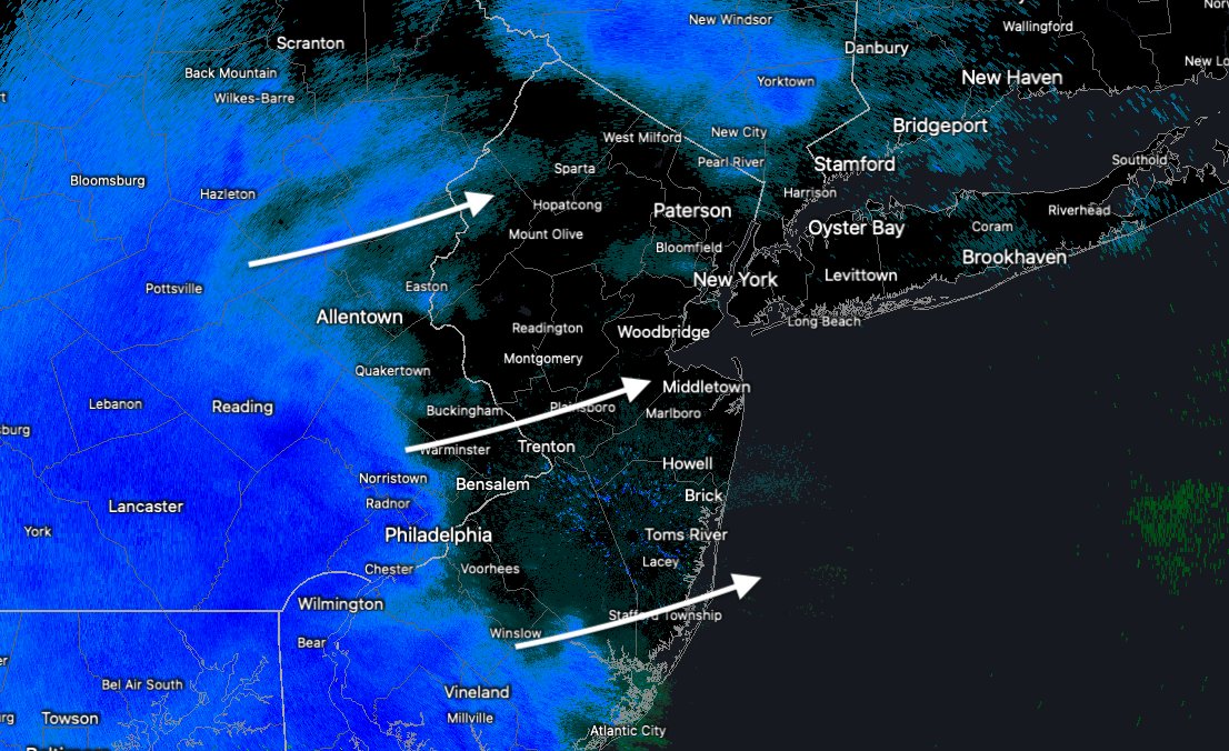
Hope so Al, WWA only for Northern WC but we will see, I wil ltake 1-2 to add a nice white cover to the dirty snow.algae888 wrote:Precip looks to arrive quicker than guidance

jmanley32- Senior Enthusiast
- Posts : 20516
Reputation : 108
Join date : 2013-12-12
Age : 42
Location : Yonkers, NY
Re: Monday's N&W Snowfall
![]() by amugs Mon Feb 22, 2021 9:44 am
by amugs Mon Feb 22, 2021 9:44 am
jmanley32 wrote:Hope so Al, WWA only for Northern WC but we will see, I wil ltake 1-2 to add a nice white cover to the dirty snow.algae888 wrote:Precip looks to arrive quicker than guidance
dirty snow is called SNIRT LOL!!
Gonna be fast and furious snowfall - going to catch many by surprise I believe - wife at work school is open until 1:30 which is he normal time in the VID world now - said they will be fine with school open until then in Western Bergen County - NOT thinking so.
.gif.a7ff0ae007945d64fada2be632009e99.gif)
_________________
Mugs
AKA:King: Snow Weenie
Self Proclaimed
WINTER 2014-15 : 55.12" +.02 for 6 coatings (avg. 35")
WINTER 2015-16 Total - 29.8" (Avg 35")
WINTER 2016-17 : 39.5" so far
amugs- Advanced Forecaster - Mod
- Posts : 15093
Reputation : 213
Join date : 2013-01-07
Age : 54
Location : Hillsdale,NJ
Re: Monday's N&W Snowfall
![]() by amugs Mon Feb 22, 2021 9:48 am
by amugs Mon Feb 22, 2021 9:48 am
SNOW MAN reports?
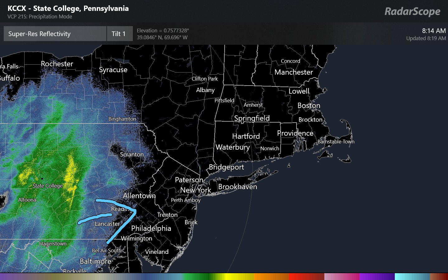
Hearing near whiteout conditions in the Reading and Allentown Areas.
_________________
Mugs
AKA:King: Snow Weenie
Self Proclaimed
WINTER 2014-15 : 55.12" +.02 for 6 coatings (avg. 35")
WINTER 2015-16 Total - 29.8" (Avg 35")
WINTER 2016-17 : 39.5" so far
amugs- Advanced Forecaster - Mod
- Posts : 15093
Reputation : 213
Join date : 2013-01-07
Age : 54
Location : Hillsdale,NJ
Re: Monday's N&W Snowfall
![]() by SENJsnowman Mon Feb 22, 2021 9:56 am
by SENJsnowman Mon Feb 22, 2021 9:56 am
docstox12 wrote:jmanley32 wrote:Well doc and CP this is a razor thin cutoff where that extra 20 to 25 miles north would give me 2 to 4 and instead rain here. I might just take a drive up to 287 to see the snow. So crazy its go rain here and 20 min drive or less with no traffic and boom 2 to 4. It is what it is but dang.
Crazy cut offs very true.I have a mini climate situation where I live.Down on Route 17 by the Red Apple Rest, it can be raining, while up by me on the mountain 700 feet up, it's freezing rain or snow.I've seen it with my own eyes.Thinking you will get 2 to 4 as this has shifted S and E according to the models yesterday.Hold fast!
Doc, I have the same thing by me, due to bodies of water rather than elevation. I got the Bay just to my east and the Toms River just to my north. The micro climate is an AWESOME -2/3* in the summer and a potentially DISASTROUS +2/3* in the winter time. Not sure how familiar you are with Ocean Gate, your sis has it even worse than I do cuz that beautiful little town (we buy the beach badges and passes to the new water spout every summer. Can't wait for that again actually. The whole town of Bayville buys Ocean Gate beach badges. It's like how South Floridians took over the Ashville NC mountain area. lol) whoa, where was I? Oh yeah, Ocean Gate is actually entirely bordered by the confluence of the River into the Bay. I'm at least a mile or so off the water in each direction, basically separated from the water by Ocean Gate in each direction.
hyde345 wrote:Irish wrote:hyde345 wrote:I don't understand NWS Albany calling for only 1/2 inch by me. They say snow for a brief period then rain/snow mix limiting accums. All models show all or mostly snow with 2-3 inches by me north of 84.
Either way, does it really matter? It's basically a non-event. Set your eyes to the future kind gent.
I was expecting a 2-3 inch type event in a 3-4 hour period with some good snow rates which I still think is possible. That's not a non event. A 1/2 inch with mixed snow/rain is just blah.
Irish, your fiesty man...lol 2-3" is a major haul in these southern parts...just one snow zone over. lol...But I agree, the future prob has at least one more biggie for the 95 zone.
Hyde, that's been the bitter pill in this month this far south. Just out of the snow zone and into that 1/2 inch with mix snow/rain for hours on end that actually lasted for 2 days...twice. No, I'm not over Macho Grande. And 'blah' is not my 4 letter word of choice when that happens! But there's my goal for personal growth this year!
Good luck N and W. Latest trends seem to bode well for you all.
Last edited by SENJsnowman on Mon Feb 22, 2021 9:57 am; edited 1 time in total
SENJsnowman- Senior Enthusiast
- Posts : 1186
Reputation : 61
Join date : 2017-01-06
Age : 51
Location : Bayville, NJ
Re: Monday's N&W Snowfall
![]() by amugs Mon Feb 22, 2021 9:57 am
by amugs Mon Feb 22, 2021 9:57 am
_________________
Mugs
AKA:King: Snow Weenie
Self Proclaimed
WINTER 2014-15 : 55.12" +.02 for 6 coatings (avg. 35")
WINTER 2015-16 Total - 29.8" (Avg 35")
WINTER 2016-17 : 39.5" so far
amugs- Advanced Forecaster - Mod
- Posts : 15093
Reputation : 213
Join date : 2013-01-07
Age : 54
Location : Hillsdale,NJ
Re: Monday's N&W Snowfall
![]() by heehaw453 Mon Feb 22, 2021 10:00 am
by heehaw453 Mon Feb 22, 2021 10:00 am
Heavy snow. Started moderate and went right to heavy. It is accumulating on sidewalk/driveway/street.
heehaw453- Advanced Forecaster
- Posts : 3906
Reputation : 86
Join date : 2014-01-20
Location : Bedminster Township, PA Elevation 600' ASL
Re: Monday's N&W Snowfall
![]() by Vinnydula Mon Feb 22, 2021 10:01 am
by Vinnydula Mon Feb 22, 2021 10:01 am

Vinnydula- Pro Enthusiast

- Posts : 778
Reputation : 8
Join date : 2013-12-12
Location : Dobbs ferry
Re: Monday's N&W Snowfall
![]() by heehaw453 Mon Feb 22, 2021 10:09 am
by heehaw453 Mon Feb 22, 2021 10:09 am

heehaw453- Advanced Forecaster
- Posts : 3906
Reputation : 86
Join date : 2014-01-20
Location : Bedminster Township, PA Elevation 600' ASL
Re: Monday's N&W Snowfall
![]() by heehaw453 Mon Feb 22, 2021 10:15 am
by heehaw453 Mon Feb 22, 2021 10:15 am
30.2/27.3
heehaw453- Advanced Forecaster
- Posts : 3906
Reputation : 86
Join date : 2014-01-20
Location : Bedminster Township, PA Elevation 600' ASL
Re: Monday's N&W Snowfall
![]() by algae888 Mon Feb 22, 2021 10:15 am
by algae888 Mon Feb 22, 2021 10:15 am
algae888- Advanced Forecaster
- Posts : 5311
Reputation : 46
Join date : 2013-02-05
Age : 61
Location : mt. vernon, new york
Re: Monday's N&W Snowfall
![]() by heehaw453 Mon Feb 22, 2021 10:20 am
by heehaw453 Mon Feb 22, 2021 10:20 am
Other observation is when the heavy bands come in there is a lot of wind that gets kicked up. I'm snowing at 2"/hr now. Much better snow growth than the last storm due to much colder mid-levels.
30.1/27.5
heehaw453- Advanced Forecaster
- Posts : 3906
Reputation : 86
Join date : 2014-01-20
Location : Bedminster Township, PA Elevation 600' ASL
Re: Monday's N&W Snowfall
![]() by aiannone Mon Feb 22, 2021 10:21 am
by aiannone Mon Feb 22, 2021 10:21 am
_________________
-Alex Iannone-

aiannone- Senior Enthusiast - Mod
- Posts : 4813
Reputation : 92
Join date : 2013-01-07
Location : Saint James, LI (Northwest Suffolk Co.)
Re: Monday's N&W Snowfall
![]() by hyde345 Mon Feb 22, 2021 10:23 am
by hyde345 Mon Feb 22, 2021 10:23 am
SENJsnowman wrote:docstox12 wrote:jmanley32 wrote:Well doc and CP this is a razor thin cutoff where that extra 20 to 25 miles north would give me 2 to 4 and instead rain here. I might just take a drive up to 287 to see the snow. So crazy its go rain here and 20 min drive or less with no traffic and boom 2 to 4. It is what it is but dang.
Crazy cut offs very true.I have a mini climate situation where I live.Down on Route 17 by the Red Apple Rest, it can be raining, while up by me on the mountain 700 feet up, it's freezing rain or snow.I've seen it with my own eyes.Thinking you will get 2 to 4 as this has shifted S and E according to the models yesterday.Hold fast!
Doc, I have the same thing by me, due to bodies of water rather than elevation. I got the Bay just to my east and the Toms River just to my north. The micro climate is an AWESOME -2/3* in the summer and a potentially DISASTROUS +2/3* in the winter time. Not sure how familiar you are with Ocean Gate, your sis has it even worse than I do cuz that beautiful little town (we buy the beach badges and passes to the new water spout every summer. Can't wait for that again actually. The whole town of Bayville buys Ocean Gate beach badges. It's like how South Floridians took over the Ashville NC mountain area. lol) whoa, where was I? Oh yeah, Ocean Gate is actually entirely bordered by the confluence of the River into the Bay. I'm at least a mile or so off the water in each direction, basically separated from the water by Ocean Gate in each direction.hyde345 wrote:Irish wrote:hyde345 wrote:I don't understand NWS Albany calling for only 1/2 inch by me. They say snow for a brief period then rain/snow mix limiting accums. All models show all or mostly snow with 2-3 inches by me north of 84.
Either way, does it really matter? It's basically a non-event. Set your eyes to the future kind gent.
I was expecting a 2-3 inch type event in a 3-4 hour period with some good snow rates which I still think is possible. That's not a non event. A 1/2 inch with mixed snow/rain is just blah.
Irish, your fiesty man...lol 2-3" is a major haul in these southern parts...just one snow zone over. lol...But I agree, the future prob has at least one more biggie for the 95 zone.
Hyde, that's been the bitter pill in this month this far south. Just out of the snow zone and into that 1/2 inch with mix snow/rain for hours on end that actually lasted for 2 days...twice. No, I'm not over Macho Grande. And 'blah' is not my 4 letter word of choice when that happens! But there's my goal for personal growth this year!
Good luck N and W. Latest trends seem to bode well for you all.
Yeah, my problem was NWS Albany calling for rain/snow mix with 1/2 inch when all guidance showed otherwise. It didn't compute. Then this morning they issue a WWA for 2-5 inches. That was a poor job by them IMO.

hyde345- Pro Enthusiast
- Posts : 1082
Reputation : 48
Join date : 2013-01-08
Location : Hyde Park, NY
Re: Monday's N&W Snowfall
![]() by heehaw453 Mon Feb 22, 2021 10:26 am
by heehaw453 Mon Feb 22, 2021 10:26 am
hyde345 wrote:SENJsnowman wrote:docstox12 wrote:jmanley32 wrote:Well doc and CP this is a razor thin cutoff where that extra 20 to 25 miles north would give me 2 to 4 and instead rain here. I might just take a drive up to 287 to see the snow. So crazy its go rain here and 20 min drive or less with no traffic and boom 2 to 4. It is what it is but dang.
Crazy cut offs very true.I have a mini climate situation where I live.Down on Route 17 by the Red Apple Rest, it can be raining, while up by me on the mountain 700 feet up, it's freezing rain or snow.I've seen it with my own eyes.Thinking you will get 2 to 4 as this has shifted S and E according to the models yesterday.Hold fast!
Doc, I have the same thing by me, due to bodies of water rather than elevation. I got the Bay just to my east and the Toms River just to my north. The micro climate is an AWESOME -2/3* in the summer and a potentially DISASTROUS +2/3* in the winter time. Not sure how familiar you are with Ocean Gate, your sis has it even worse than I do cuz that beautiful little town (we buy the beach badges and passes to the new water spout every summer. Can't wait for that again actually. The whole town of Bayville buys Ocean Gate beach badges. It's like how South Floridians took over the Ashville NC mountain area. lol) whoa, where was I? Oh yeah, Ocean Gate is actually entirely bordered by the confluence of the River into the Bay. I'm at least a mile or so off the water in each direction, basically separated from the water by Ocean Gate in each direction.hyde345 wrote:Irish wrote:hyde345 wrote:I don't understand NWS Albany calling for only 1/2 inch by me. They say snow for a brief period then rain/snow mix limiting accums. All models show all or mostly snow with 2-3 inches by me north of 84.
Either way, does it really matter? It's basically a non-event. Set your eyes to the future kind gent.
I was expecting a 2-3 inch type event in a 3-4 hour period with some good snow rates which I still think is possible. That's not a non event. A 1/2 inch with mixed snow/rain is just blah.
Irish, your fiesty man...lol 2-3" is a major haul in these southern parts...just one snow zone over. lol...But I agree, the future prob has at least one more biggie for the 95 zone.
Hyde, that's been the bitter pill in this month this far south. Just out of the snow zone and into that 1/2 inch with mix snow/rain for hours on end that actually lasted for 2 days...twice. No, I'm not over Macho Grande. And 'blah' is not my 4 letter word of choice when that happens! But there's my goal for personal growth this year!
Good luck N and W. Latest trends seem to bode well for you all.
Yeah, my problem was NWS Albany calling for rain/snow mix with 1/2 inch when all guidance showed otherwise. It didn't compute. Then this morning they issue a WWA for 2-5 inches. That was a poor job by them IMO.
I don't like to bad mouth the NWS, but Mt Holly was late to the party on this one in EPA. The writing was on the wall with this threat for 36 hours. I won't even discuss AccuWeather.
heehaw453- Advanced Forecaster
- Posts : 3906
Reputation : 86
Join date : 2014-01-20
Location : Bedminster Township, PA Elevation 600' ASL
hyde345 likes this post
Re: Monday's N&W Snowfall
![]() by MikeA Mon Feb 22, 2021 10:29 am
by MikeA Mon Feb 22, 2021 10:29 am
MikeA- Posts : 11
Reputation : 0
Join date : 2021-02-01
Age : 48
Location : 5 miles west of Flemington, NJ
essexcountypete likes this post
Page 2 of 7 • 1, 2, 3, 4, 5, 6, 7 ![]()
|
|
|