Long Range Thread 28.0
+33
weatherwatchermom
essexcountypete
skinsfan1177
aiannone
larryrock72
Coachgriff
DAYBLAZER
nutleyblizzard
hyde345
docstox12
CPcantmeasuresnow
frank 638
Koroptim
HectorO
billg315
dkodgis
MattyICE
toople
sroc4
rb924119
Grselig
crippo84
phil155
Frank_Wx
jmanley32
NJBear
tomsriversnowstorm
Carvin
heehaw453
SENJsnowman
Irish
amugs
richb521
37 posters
Page 9 of 18
Page 9 of 18 •  1 ... 6 ... 8, 9, 10 ... 13 ... 18
 Re: Long Range Thread 28.0
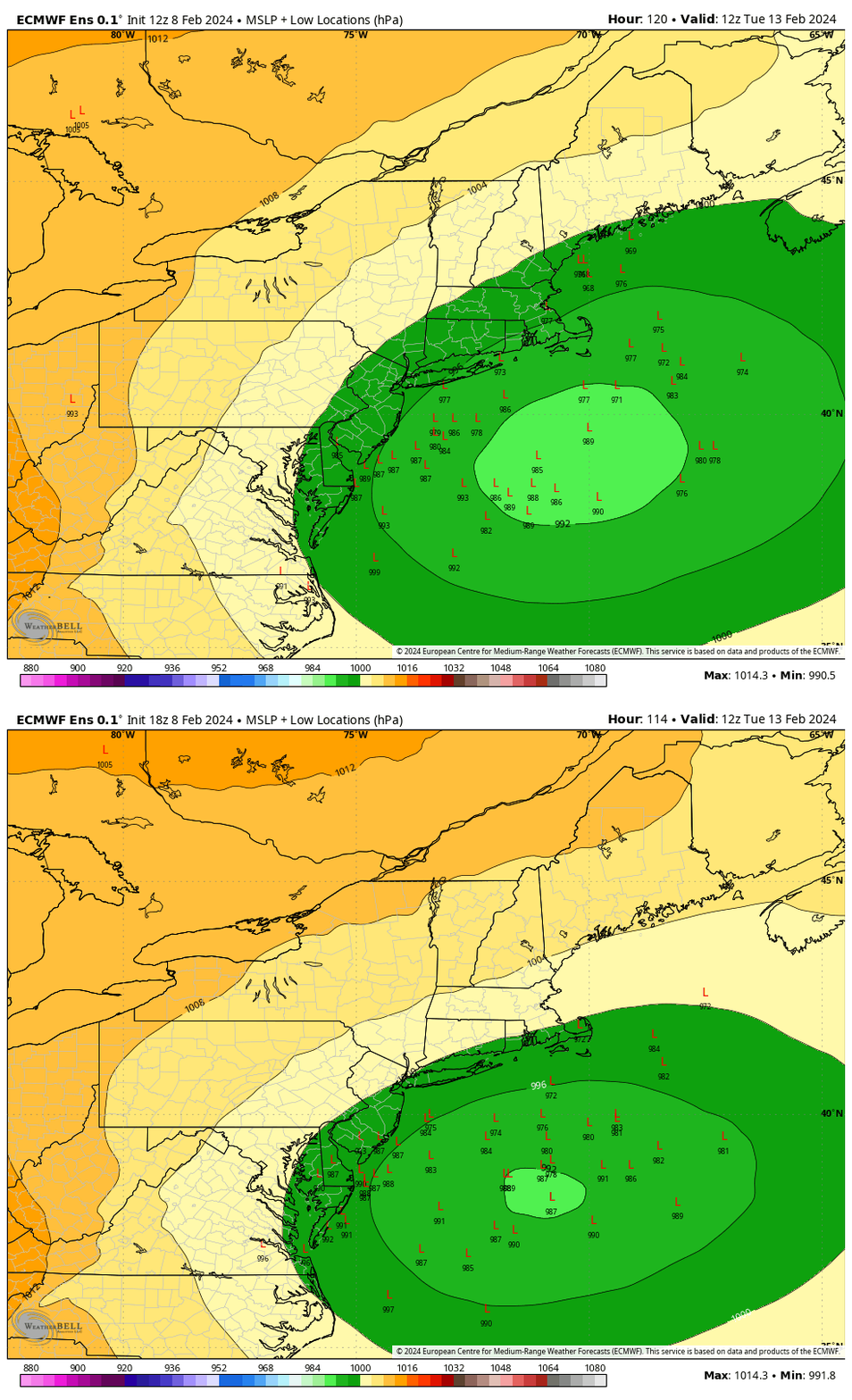
The trends to the ensembles have also been favorable. Last four EPS runs. Two things to pay attn to. First the Low locations cont to trends S. And second all images are valid for the same time stamp. The storm is trending slower. This slower trend, which is also trending on all op runs to, allows more time for the cold air to filter in.


sroc4- Admin

- Posts : 8331
Join date : 2013-01-07
essexcountypete and jmanley32 like this post
 Re: Long Range Thread 28.0
Not much time for analysis. I looked at the 12Z EPS and there is more n/s trough linking to the Atlantic trough for h5 vorticity. It favors a southerly solution IMO. If this works the NAO will have done its work like I believe it will. IMO the only shot at BIG amounts are if that confluence forms coupled with a good injection of n/s energy. I'd put that on the lower end of possibilities for now. Not to say there is not a shot for substantial snowfall (3+) with this. Just all things must align for the > 6" IMO
heehaw453- Advanced Forecaster

- Posts : 3906
Join date : 2014-01-20
 Re: Long Range Thread 28.0
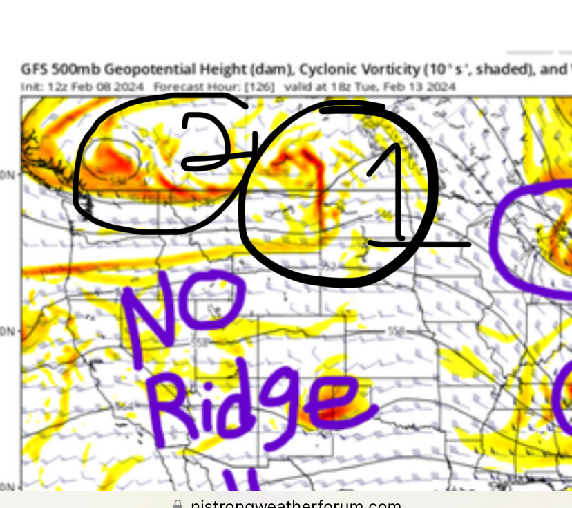
sroc4 wrote:SENJsnowman wrote:Hyde, I hate to say it, but I’m definitely seeing it the same way. Just my instinctive reactions to all of the analysis and modeling that has been posted, as well as the trend that has been in place basically all winter for the southern areas to be too warm. And the real trend that has been 100% inescapable the whole winter for the whole area: NO PHASE FOR YOU!!!!
Once that piece of trailing energy was detected as a threat to western CONUS ridge, it seems like that has been the dominant feature of the tracking. If I’m not mistaken, we actually two have TWO culprits knocking down the ridge.
So, I’ll be quite happy to be wrong (fortunately, I’m good at that!), but at the moment, I’m just not feeling so optimistic. But I am feeling appreciation and gratitude towards everyone on here who has been posting analysis and tracking and contributing. Last winter was far worse imo, there was basically zero threats to track, especially inside D4-5.
honestlyna ridge can be overcome. Frank only showed the CONUS view. There is still a stout ridge going up along the WC o Canada. This is too far south to call it pure -EPO and too far north to call it a pure +PNA. Even though the ridge along the immediate WC of the CONUS flattens there is still a hard presss of cold compliments of the WC Canada ridge and the 50/50 LP in the N Atlantic. There are a few finer details in between that need ironing out but this is still doable for sure.
Thanks for pointing that out SRoc. That ridge in W Canada is stout for sure…it’s stout like Guinness! Ha ha.
So my follow up question then is about phasing. Does the Canadian ridge as modeled in the 12z GFS that Frank posted in any way allow for the two streams to phase? Or do we need a Rockies ridge to create the proper timing for that to happen? Or are there still other mechanisms that can bring about the all elusive phasing?
SENJsnowman- Senior Enthusiast

- Posts : 1186
Reputation : 61
Join date : 2017-01-06
Age : 51
Location : Bayville, NJ
sroc4 likes this post
 Re: Long Range Thread 28.0
SENJsnowman wrote:sroc4 wrote:SENJsnowman wrote:Hyde, I hate to say it, but I’m definitely seeing it the same way. Just my instinctive reactions to all of the analysis and modeling that has been posted, as well as the trend that has been in place basically all winter for the southern areas to be too warm. And the real trend that has been 100% inescapable the whole winter for the whole area: NO PHASE FOR YOU!!!!
Once that piece of trailing energy was detected as a threat to western CONUS ridge, it seems like that has been the dominant feature of the tracking. If I’m not mistaken, we actually two have TWO culprits knocking down the ridge.
So, I’ll be quite happy to be wrong (fortunately, I’m good at that!), but at the moment, I’m just not feeling so optimistic. But I am feeling appreciation and gratitude towards everyone on here who has been posting analysis and tracking and contributing. Last winter was far worse imo, there was basically zero threats to track, especially inside D4-5.
honestlyna ridge can be overcome. Frank only showed the CONUS view. There is still a stout ridge going up along the WC o Canada. This is too far south to call it pure -EPO and too far north to call it a pure +PNA. Even though the ridge along the immediate WC of the CONUS flattens there is still a hard presss of cold compliments of the WC Canada ridge and the 50/50 LP in the N Atlantic. There are a few finer details in between that need ironing out but this is still doable for sure.
Thanks for pointing that out SRoc. That ridge in W Canada is stout for sure…it’s stout like Guinness! Ha ha.
So my follow up question then is about phasing. Does the Canadian ridge as modeled in the 12z GFS that Frank posted in any way allow for the two streams to phase? Or do we need a Rockies ridge to create the proper timing for that to happen? Or are there still other mechanisms that can bring about the all elusive phasing?
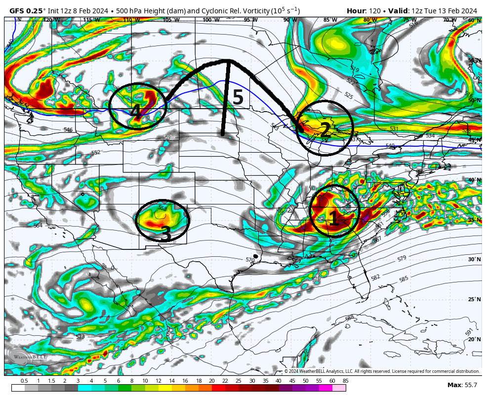
Its easy to get lost if you follow too many models. In general if yuou monitor the trends at H5 with both GFS and Euro to see how they everntually come to the consensus, and or if you look at the storm tracks for both, in the vast majority of the instances the truth lies somewhere in the middle. In years past Id say the truth to storm track almost always leans closer to the Euro, but in recent past its been more of a crap shoot.
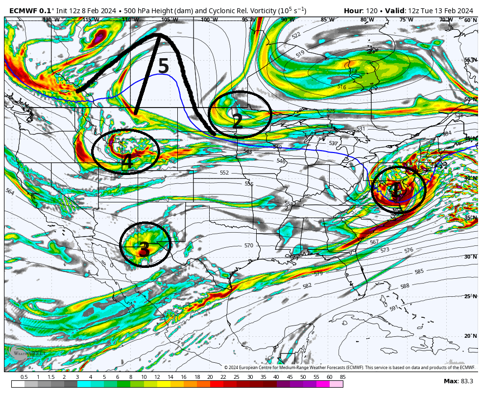
Now if we zoom into just the CONUSD, of course understanding that the N Atlantic and N Pac are playing a role too, if you pay attention to the 5 areas I have labeled you can see the differences. 1 & 2 are the s/s and n/s energy. You can see that the GFS is the slowest soln with the H5 energy. The result is the n/s energy can just about catch up to it, but it also steers the s/s energy early on hence why its the furthest south soln atm.
Also notice the position diff in 3, and 4. The seperation between 4 and 2 allows a small ridge(5) to pop allowing 2 to dig enough to phase albeit a tad late. Whereas; the Euro 1 is faster, 2 is slower, 4 and 3 are further south, so 5 pops too far west.
All of these subtle yet extremely important differences still all need to be worked out. Because f the bg picture in the N Atlantic, and the N Pac is setting up to be in a favorable state, this is why I truly believe the PNA along the WC can still be overcome, but you can see alot has to be sorted out. Again Sat at the earliest.
_________________
"In weather and in life, there's no winning and losing; there's only winning and learning."
WINTER 2012/2013 TOTALS 43.65"WINTER 2017/2018 TOTALS 62.85" WINTER 2022/2023 TOTALS 4.9"
WINTER 2013/2014 TOTALS 64.85"WINTER 2018/2019 TOTALS 14.25" WINTER 2023/2024 TOTALS 13.1"
WINTER 2014/2015 TOTALS 71.20"WINTER 2019/2020 TOTALS 6.35"
WINTER 2015/2016 TOTALS 35.00"WINTER 2020/2021 TOTALS 37.75"
WINTER 2016/2017 TOTALS 42.25"WINTER 2021/2022 TOTALS 31.65"

sroc4- Admin

- Posts : 8331
Reputation : 301
Join date : 2013-01-07
Location : Wading River, LI
 Re: Long Range Thread 28.0
One thing I would say about the GFS solution, and I'm not saying it's going to happen, but the last of the snow events we had in mid-January delivered substantial snow in South Jersey - 7" plus in some spots, while many areas in North Jersey were lucky to get 1". And sometimes in a winter, history likes to repeat itself with certain outcomes. Southern sliders are actually not uncommon, maybe even more prevalent, in El Nino winters. That gives me pause about writing off the GFS right now.
In any event, there is so much time before we hone-in on a solution that I'm not really putting my eggs in any basket just yet.
In any event, there is so much time before we hone-in on a solution that I'm not really putting my eggs in any basket just yet.

billg315- Advanced Forecaster - Mod

- Posts : 4467
Reputation : 185
Join date : 2015-01-24
Age : 50
Location : Flemington, NJ
sroc4 likes this post
 Re: Long Range Thread 28.0
Thank you SRoc- very clear and easy to follow explanation! Thanks to you to Bill, very helpful (and hopeful!) insights.
Ok, no more questions for the moment. Time to get back to work and time to track!
Ok, no more questions for the moment. Time to get back to work and time to track!

SENJsnowman- Senior Enthusiast

- Posts : 1186
Reputation : 61
Join date : 2017-01-06
Age : 51
Location : Bayville, NJ
sroc4 likes this post
 Re: Long Range Thread 28.0
SENJsnowman wrote:Thank you SRoc- very clear and easy to follow explanation! Thanks to you to Bill, very helpful (and hopeful!) insights.
Ok, no more questions for the moment. Time to get back to work and time to track!
If you have questions fire away. Ill try to answer best I can. Cant promise I wont be talking out of my Ars though...
_________________
"In weather and in life, there's no winning and losing; there's only winning and learning."
WINTER 2012/2013 TOTALS 43.65"WINTER 2017/2018 TOTALS 62.85" WINTER 2022/2023 TOTALS 4.9"
WINTER 2013/2014 TOTALS 64.85"WINTER 2018/2019 TOTALS 14.25" WINTER 2023/2024 TOTALS 13.1"
WINTER 2014/2015 TOTALS 71.20"WINTER 2019/2020 TOTALS 6.35"
WINTER 2015/2016 TOTALS 35.00"WINTER 2020/2021 TOTALS 37.75"
WINTER 2016/2017 TOTALS 42.25"WINTER 2021/2022 TOTALS 31.65"

sroc4- Admin

- Posts : 8331
Reputation : 301
Join date : 2013-01-07
Location : Wading River, LI
docstox12 and SENJsnowman like this post
 Re: Long Range Thread 28.0
Here is Bernie’s take from today. Given how the winter has gone it’s certainly as reasonable an outcome as any at this stage.
_________________
"In weather and in life, there's no winning and losing; there's only winning and learning."
WINTER 2012/2013 TOTALS 43.65"WINTER 2017/2018 TOTALS 62.85" WINTER 2022/2023 TOTALS 4.9"
WINTER 2013/2014 TOTALS 64.85"WINTER 2018/2019 TOTALS 14.25" WINTER 2023/2024 TOTALS 13.1"
WINTER 2014/2015 TOTALS 71.20"WINTER 2019/2020 TOTALS 6.35"
WINTER 2015/2016 TOTALS 35.00"WINTER 2020/2021 TOTALS 37.75"
WINTER 2016/2017 TOTALS 42.25"WINTER 2021/2022 TOTALS 31.65"

sroc4- Admin

- Posts : 8331
Reputation : 301
Join date : 2013-01-07
Location : Wading River, LI
MattyICE and phil155 like this post
 Re: Long Range Thread 28.0
18Z GFS continues the idea of confluence with more n/s energy injected into the s/s. if we get the sweet spot of just enough confluence with that additional energy this will be 6"+ no problem whatsoever.
heehaw453- Advanced Forecaster

- Posts : 3906
Reputation : 86
Join date : 2014-01-20
Location : Bedminster Township, PA Elevation 600' ASL
Grselig and frank 638 like this post
 Re: Long Range Thread 28.0
heehaw453 wrote:18Z GFS continues the idea of confluence with more n/s energy injected into the s/s. if we get the sweet spot of just enough confluence with that additional energy this will be 6"+ no problem whatsoever.
Nothing like seeing 18z gfs with 126hrs to go hit my back yards bullseye. What could go wrong? Lol
_________________
"In weather and in life, there's no winning and losing; there's only winning and learning."
WINTER 2012/2013 TOTALS 43.65"WINTER 2017/2018 TOTALS 62.85" WINTER 2022/2023 TOTALS 4.9"
WINTER 2013/2014 TOTALS 64.85"WINTER 2018/2019 TOTALS 14.25" WINTER 2023/2024 TOTALS 13.1"
WINTER 2014/2015 TOTALS 71.20"WINTER 2019/2020 TOTALS 6.35"
WINTER 2015/2016 TOTALS 35.00"WINTER 2020/2021 TOTALS 37.75"
WINTER 2016/2017 TOTALS 42.25"WINTER 2021/2022 TOTALS 31.65"

sroc4- Admin

- Posts : 8331
Reputation : 301
Join date : 2013-01-07
Location : Wading River, LI
essexcountypete, billg315 and frank 638 like this post
 Re: Long Range Thread 28.0
billg315 wrote:If the last two GFS runs came to fruition (and I think a lot of variables are still out there to shake things up with this forecast) our NJ Shore folks (are you listening SENJ Snowman??) would get a big time snowstorm out of this.
Mid to upper 50's Friday and Saturday. Sunday-Tues mid 40's. Overnight temps never get below freezing until Tuesday night. I can't see South Jersey getting any snow unless this system slows down.
larryrock72- Posts : 140
Reputation : 5
Join date : 2017-01-03
Age : 52
Location : Barnegat, NJ
sroc4, weatherwatchermom and frank 638 like this post

aiannone- Senior Enthusiast - Mod

- Posts : 4813
Reputation : 92
Join date : 2013-01-07
Location : Saint James, LI (Northwest Suffolk Co.)
frank 638 likes this post

nutleyblizzard- Senior Enthusiast

- Posts : 1952
Reputation : 41
Join date : 2014-01-30
Age : 58
Location : Nutley, new jersey

nutleyblizzard- Senior Enthusiast

- Posts : 1952
Reputation : 41
Join date : 2014-01-30
Age : 58
Location : Nutley, new jersey
 Re: Long Range Thread 28.0
Pretty clear the Euro has been moving more in-line with the GFS all day. Now will that hold for the next two-three days? Who knows. Heck, who knows if it will hold for the next set of model runs. lol. Now, when one model starts caving toward another, it's often a sign the model that has been staying consistent is on to something. But that would mean a lot more to me if we were within 24-48 hours of the event. Four days out, plenty of time for both models to swing back the other way. Also, as the Euro has trended south the GFS did trend a bit north in the last run. So maybe they're just trying to meet in the middle in the spirit of compromise. For my locale (and maybe a majority of the folks on here), that would be just fine. :-)

billg315- Advanced Forecaster - Mod

- Posts : 4467
Reputation : 185
Join date : 2015-01-24
Age : 50
Location : Flemington, NJ
 Re: Long Range Thread 28.0
The sun will rise and give new counsel on the matter tonorrow

dkodgis- Senior Enthusiast

- Posts : 2501
Reputation : 98
Join date : 2013-12-29
docstox12 and billg315 like this post
 Re: Long Range Thread 28.0
Good things afoot. No spiking the football but we're in the game at least and I like where we are on the field.
heehaw453- Advanced Forecaster

- Posts : 3906
Reputation : 86
Join date : 2014-01-20
Location : Bedminster Township, PA Elevation 600' ASL
Grselig likes this post
 Re: Long Range Thread 28.0
billg315 wrote:Pretty clear the Euro has been moving more in-line with the GFS all day. Now will that hold for the next two-three days? Who knows. Heck, who knows if it will hold for the next set of model runs. lol. Now, when one model starts caving toward another, it's often a sign the model that has been staying consistent is on to something. But that would mean a lot more to me if we were within 24-48 hours of the event. Four days out, plenty of time for both models to swing back the other way. Also, as the Euro has trended south the GFS did trend a bit north in the last run. So maybe they're just trying to meet in the middle in the spirit of compromise. For my locale (and maybe a majority of the folks on here), that would be just fine. :-)
I don't think it is the Euro caving to the GFS at all. The GFS moved significantly further north at 18z.

hyde345- Pro Enthusiast

- Posts : 1082
Reputation : 48
Join date : 2013-01-08
Location : Hyde Park, NY
 Re: Long Range Thread 28.0
We'll see if GFS is right. 00Z GGEM further south too. GFS is aggressive with the negative tilt of the h5 trough as well as rapid deepening of the storm. It's fed with a lot of n/s energy as it's maturing. That would be path to something sig. I'm not quite there yet to say sig event though. As shown this storm cannot get much further north. Too much resistance up top which also increase lift as the storm hits the resistance. All I can say this solution matches what I would expect with the MJO and teleconnections.


heehaw453- Advanced Forecaster

- Posts : 3906
Reputation : 86
Join date : 2014-01-20
Location : Bedminster Township, PA Elevation 600' ASL

nutleyblizzard- Senior Enthusiast

- Posts : 1952
Reputation : 41
Join date : 2014-01-30
Age : 58
Location : Nutley, new jersey
docstox12 and phil155 like this post
 Re: Long Range Thread 28.0
hyde345 wrote:billg315 wrote:Pretty clear the Euro has been moving more in-line with the GFS all day. Now will that hold for the next two-three days? Who knows. Heck, who knows if it will hold for the next set of model runs. lol. Now, when one model starts caving toward another, it's often a sign the model that has been staying consistent is on to something. But that would mean a lot more to me if we were within 24-48 hours of the event. Four days out, plenty of time for both models to swing back the other way. Also, as the Euro has trended south the GFS did trend a bit north in the last run. So maybe they're just trying to meet in the middle in the spirit of compromise. For my locale (and maybe a majority of the folks on here), that would be just fine. :-)
I don't think it is the Euro caving to the GFS at all. The GFS moved significantly further north at 18z.
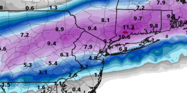
I respectfully have to disagree. The Euro was a rainstorm for the entire state of NJ and NYC and LI, with the heaviest snow up near Albany, whereas GFS was a snowstorm for the southern half of NJ with some snow in NNj. Euro moved south and now is a snowstorm for the northern half of NJ NYC and LI with a cutoff at or south of Albany, whereas GFS is still a snowstorm for most of NJ except extreme southeast NJ. Both models now have axis of heaviest snow in NJ which is closer to where GfS was/is.
They have both moved toward the middle but Euro is much colder/further south than it was 24 hours ago. That said, I again emphasize both models still have plenty of time to shift in any direction.

billg315- Advanced Forecaster - Mod

- Posts : 4467
Reputation : 185
Join date : 2015-01-24
Age : 50
Location : Flemington, NJ
docstox12 and Irish like this post
 Re: Long Range Thread 28.0
06z gfs is a monster. Godzilla for metro. Would be nice. And vday is nutorious for good storms. Do i buy it? Not yet. But verbatim gfs is 12 to 18.

jmanley32- Senior Enthusiast

- Posts : 20516
Reputation : 108
Join date : 2013-12-12
Age : 42
Location : Yonkers, NY
SENJsnowman likes this post
 Re: Long Range Thread 28.0
Upton not buying it
Without much in the way of phasing of northern and southern branches
of the upper jet with the southerly branch being the more dominant
one, there is a limit to how amplified the wave gets. There is not
much tilt vertically. This favors a relatively faster and more
progressive solution. Also evident, is a lack of a strong high
pressure area to lock in colder air. It will difficult to sustain
any prolonged snowfall especially if more of the precipitation falls
during the day.

skinsfan1177- Senior Enthusiast

- Posts : 4485
Reputation : 35
Join date : 2013-01-07
Age : 46
Location : Point Pleasant Boro
 Re: Long Range Thread 28.0
billg315 wrote:hyde345 wrote:billg315 wrote:Pretty clear the Euro has been moving more in-line with the GFS all day. Now will that hold for the next two-three days? Who knows. Heck, who knows if it will hold for the next set of model runs. lol. Now, when one model starts caving toward another, it's often a sign the model that has been staying consistent is on to something. But that would mean a lot more to me if we were within 24-48 hours of the event. Four days out, plenty of time for both models to swing back the other way. Also, as the Euro has trended south the GFS did trend a bit north in the last run. So maybe they're just trying to meet in the middle in the spirit of compromise. For my locale (and maybe a majority of the folks on here), that would be just fine. :-)
I don't think it is the Euro caving to the GFS at all. The GFS moved significantly further north at 18z.
I respectfully have to disagree. The Euro was a rainstorm for the entire state of NJ and NYC and LI, with the heaviest snow up near Albany, whereas GFS was a snowstorm for the southern half of NJ with some snow in NNj. Euro moved south and now is a snowstorm for the northern half of NJ NYC and LI with a cutoff at or south of Albany, whereas GFS is still a snowstorm for most of NJ except extreme southeast NJ. Both models now have axis of heaviest snow in NJ which is closer to where GfS was/is.
They have both moved toward the middle but Euro is much colder/further south than it was 24 hours ago. That said, I again emphasize both models still have plenty of time to shift in any direction.
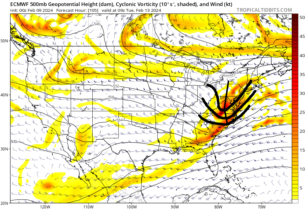
I think there is truth to both statements in reality. That said I do think overall there is a strong lean of the Euro towards the GFS soln for sure. As stated yesterday if you took the Euro as the northern most soln and the GFS as the southern most you would likely find them meeting somewhere in the middle, both at H5 and surface. It is quite clear at H5 that the euro is closer to the GFS soln as of now, but I dont think the GFS extreme soln is correct.
Here was the Euro 12z on Wed the 7th. The s/s was a strung out mess as it hit the coast and the trough was extremely progressive.
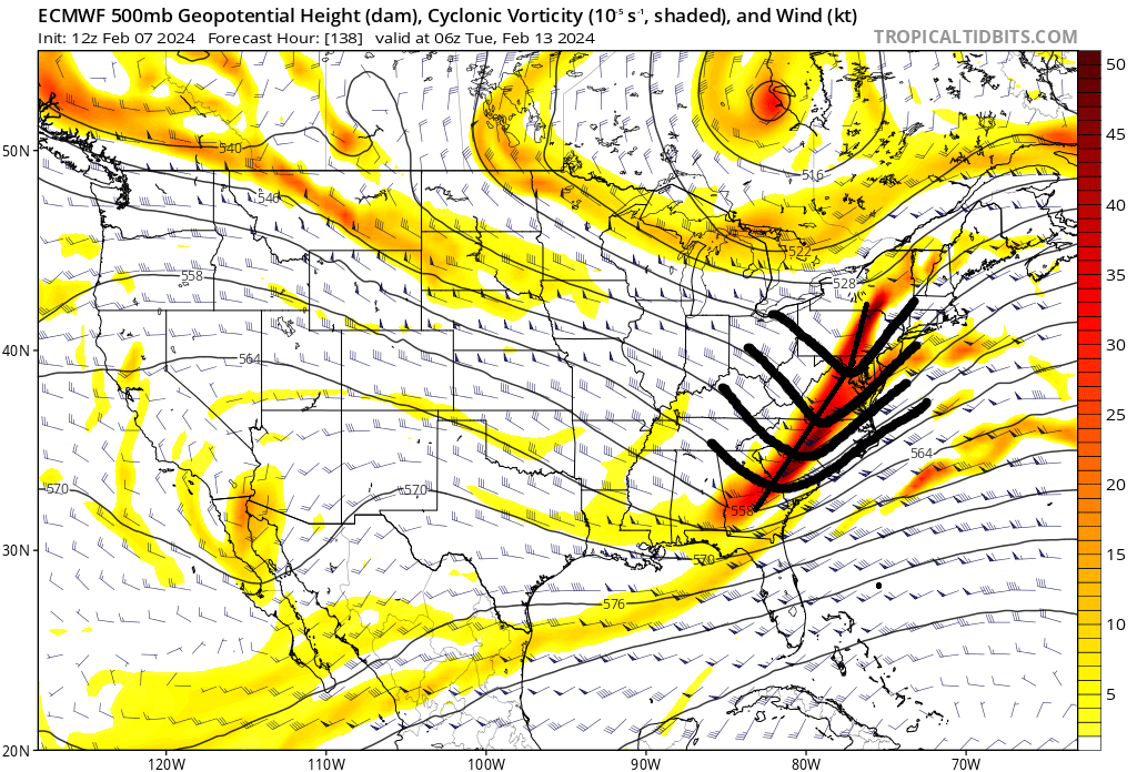
But it has trended/evolved to more consolidated vorticity with a more defined trough headed towards neutral. GFS is def the most extreme model with its trough axis tilted neg and some n/s interactions; hence the biggest snow totals, but again the outlier for now.

_________________
"In weather and in life, there's no winning and losing; there's only winning and learning."
WINTER 2012/2013 TOTALS 43.65"WINTER 2017/2018 TOTALS 62.85" WINTER 2022/2023 TOTALS 4.9"
WINTER 2013/2014 TOTALS 64.85"WINTER 2018/2019 TOTALS 14.25" WINTER 2023/2024 TOTALS 13.1"
WINTER 2014/2015 TOTALS 71.20"WINTER 2019/2020 TOTALS 6.35"
WINTER 2015/2016 TOTALS 35.00"WINTER 2020/2021 TOTALS 37.75"
WINTER 2016/2017 TOTALS 42.25"WINTER 2021/2022 TOTALS 31.65"

sroc4- Admin

- Posts : 8331
Reputation : 301
Join date : 2013-01-07
Location : Wading River, LI
 Re: Long Range Thread 28.0
06Z GEFS has some bombs for the area. Some a bit south but not really too much north anymore. In order to get the bigger amounts 6"+ going to need a dynamic storm. The surface won't be ideally cold especially on the coastal plain but mid-levels can be fine with a dynamic storm and right track. All has to go right. I'm keeping my expectations at 2-3" with potential for more.
Latest SOI value ~-46
Latest SOI value ~-46
heehaw453- Advanced Forecaster

- Posts : 3906
Reputation : 86
Join date : 2014-01-20
Location : Bedminster Township, PA Elevation 600' ASL
sroc4 likes this post
 Re: Long Range Thread 28.0
Still pretty big differences in the exact timing of the main precip. Euro has it over pretty much by early afternoon and GFS is just getting going by early afternoon. Both images valid 1pm Tuesday.
IMO the GFS although has been a bit back and forth has trended towards less n/s interactions which in the end will lead to a less amplified soln and much lower totals.


IMO the GFS although has been a bit back and forth has trended towards less n/s interactions which in the end will lead to a less amplified soln and much lower totals.


_________________
"In weather and in life, there's no winning and losing; there's only winning and learning."
WINTER 2012/2013 TOTALS 43.65"WINTER 2017/2018 TOTALS 62.85" WINTER 2022/2023 TOTALS 4.9"
WINTER 2013/2014 TOTALS 64.85"WINTER 2018/2019 TOTALS 14.25" WINTER 2023/2024 TOTALS 13.1"
WINTER 2014/2015 TOTALS 71.20"WINTER 2019/2020 TOTALS 6.35"
WINTER 2015/2016 TOTALS 35.00"WINTER 2020/2021 TOTALS 37.75"
WINTER 2016/2017 TOTALS 42.25"WINTER 2021/2022 TOTALS 31.65"

sroc4- Admin

- Posts : 8331
Reputation : 301
Join date : 2013-01-07
Location : Wading River, LI
heehaw453 and MattyICE like this post
 Re: Long Range Thread 28.0
12z GFS another tick north. 12z GFS and 0z Euro have similar look for snowfall. Have to see where the 12z Euro goes, but atm they’re pretty close to being on the same page. Three days out, take it for what it’s worth.

billg315- Advanced Forecaster - Mod

- Posts : 4467
Reputation : 185
Join date : 2015-01-24
Age : 50
Location : Flemington, NJ
Page 9 of 18 •  1 ... 6 ... 8, 9, 10 ... 13 ... 18
Page 9 of 18
Permissions in this forum:
You cannot reply to topics in this forum|
|
|

 Home
Home