
 Search
Long Range Thread 10.0
Page 27 of 28 •  1 ... 15 ... 26, 27, 28
 ![]()
Re: Long Range Thread 10.0
![]() by Math23x7 Sun Feb 21, 2016 8:55 pm
by Math23x7 Sun Feb 21, 2016 8:55 pm
docstox12 wrote:Math23x7 wrote:frank 638 wrote:amugs wrote:Arctic blast Madonne -10 to 15 departures next weekend through the Beg of March if this serves
If it is going to be this cold in March, I want the snow. If we're not getting the snow, I would just like it to be warm, especially after March 13th as that's the day that Daylight Savings Time begins.
PS: frank638, with all due respect, when you post a reply on a thread, it is probably best to post it in the main portion of the message and not in the title portion. Just my opinion though.
Agreed.Sure hope it is not a cold, rainy spring.UGH!

I would take March 2012 (no snow and the 2nd warmest March on record for CPK) over March 2014 (cold with only 0.1" of snow, which came from a system that days earlier was forecasted to give NYC 6-12" of snow.)
Math23x7- Wx Statistician Guru

- Posts : 2379
Join date : 2013-01-08
Re: Long Range Thread 10.0
![]() by Guest Sun Feb 21, 2016 9:25 pm
by Guest Sun Feb 21, 2016 9:25 pm
Guest- Guest
Re: Long Range Thread 10.0
![]() by dkodgis Sun Feb 21, 2016 9:57 pm
by dkodgis Sun Feb 21, 2016 9:57 pm

dkodgis- Senior Enthusiast

- Posts : 2492
Reputation : 98
Join date : 2013-12-29
Re: Long Range Thread 10.0
![]() by Snow88 Mon Feb 22, 2016 12:03 am
by Snow88 Mon Feb 22, 2016 12:03 am
amugs wrote:Arctic blast Madonne -10 to 15 departures next weekend through the Beg of March if this serves
GGEM cancels winter with no cold air in sight lol

Snow88- Senior Enthusiast
- Posts : 2193
Reputation : 4
Join date : 2013-01-09
Age : 35
Location : Brooklyn, NY
Re: Long Range Thread 10.0
![]() by algae888 Mon Feb 22, 2016 12:08 pm
by algae888 Mon Feb 22, 2016 12:08 pm


algae888- Advanced Forecaster

- Posts : 5311
Reputation : 46
Join date : 2013-02-05
Age : 61
Location : mt. vernon, new york
Re: Long Range Thread 10.0
![]() by docstox12 Mon Feb 22, 2016 12:13 pm
by docstox12 Mon Feb 22, 2016 12:13 pm
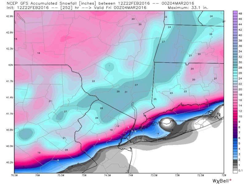
algae888 wrote:not one but two fantasy storms on 12z gfs to suck us back in...
OK, that GFS would be the one that lets us in the HV catch up to you guys S and E.The way the trends have been for these snowstorms to go S and E for years, I'd say that GFS is a 50 to 1 shot.The kind of horse at the track you bet on that comes in three hours after the race starts.Nice to look at it, though, that map could be from the 50's and 60's.

docstox12- Wx Statistician Guru
- Posts : 8497
Reputation : 222
Join date : 2013-01-07
Age : 73
Location : Monroe NY
Re: Long Range Thread 10.0
![]() by CPcantmeasuresnow Mon Feb 22, 2016 12:45 pm
by CPcantmeasuresnow Mon Feb 22, 2016 12:45 pm
A good season in any fantasy world.

CPcantmeasuresnow- Wx Statistician Guru
- Posts : 7274
Reputation : 230
Join date : 2013-01-07
Age : 103
Location : Eastern Orange County, NY
Re: Long Range Thread 10.0
![]() by Guest Mon Feb 22, 2016 1:50 pm
by Guest Mon Feb 22, 2016 1:50 pm
Guest- Guest
Re: Long Range Thread 10.0
![]() by jmanley32 Mon Feb 22, 2016 2:15 pm
by jmanley32 Mon Feb 22, 2016 2:15 pm
algae888 wrote:not one but two fantasy storms on 12z gfs to suck us back in...
That snowfall isn't even including the 2nd storm nor all of the 1st as the snow map only goes out to 240 hrs ha, reel us back in!

jmanley32- Senior Enthusiast
- Posts : 20512
Reputation : 108
Join date : 2013-12-12
Age : 42
Location : Yonkers, NY
Re: Long Range Thread 10.0
![]() by amugs Mon Feb 22, 2016 2:19 pm
by amugs Mon Feb 22, 2016 2:19 pm
2-3 days out, blocking on euro is insane, stj pumping and two big coastals on SV and what will happen??
Anyone's guess. IF thee LR OP and even the ENS maps are for real then March will be fun, JB thinks so and then we flip to spring by mid month. We shall see....
_________________
Mugs
AKA:King: Snow Weenie
Self Proclaimed
WINTER 2014-15 : 55.12" +.02 for 6 coatings (avg. 35")
WINTER 2015-16 Total - 29.8" (Avg 35")
WINTER 2016-17 : 39.5" so far

amugs- Advanced Forecaster - Mod

- Posts : 15091
Reputation : 213
Join date : 2013-01-07
Age : 54
Location : Hillsdale,NJ
Re: Long Range Thread 10.0
![]() by jmanley32 Mon Feb 22, 2016 2:19 pm
by jmanley32 Mon Feb 22, 2016 2:19 pm
jmanley32- Senior Enthusiast
- Posts : 20512
Reputation : 108
Join date : 2013-12-12
Age : 42
Location : Yonkers, NY
Re: Long Range Thread 10.0
![]() by jmanley32 Mon Feb 22, 2016 2:21 pm
by jmanley32 Mon Feb 22, 2016 2:21 pm
jmanley32- Senior Enthusiast
- Posts : 20512
Reputation : 108
Join date : 2013-12-12
Age : 42
Location : Yonkers, NY
Re: Long Range Thread 10.0
![]() by skinsfan1177 Mon Feb 22, 2016 2:25 pm
by skinsfan1177 Mon Feb 22, 2016 2:25 pm

skinsfan1177- Senior Enthusiast
- Posts : 4485
Reputation : 35
Join date : 2013-01-07
Age : 46
Location : Point Pleasant Boro
Re: Long Range Thread 10.0
![]() by docstox12 Mon Feb 22, 2016 2:45 pm
by docstox12 Mon Feb 22, 2016 2:45 pm
syosnow94 wrote:Not bad CP. so what you are saying is the long range GFS has a 5% accuracy rate predicting snowfall. ( you received 1/20th of what it predicted)
Jimmy, true up here in the HV with the forever S and E trend of these snowstorms.
docstox12- Wx Statistician Guru
- Posts : 8497
Reputation : 222
Join date : 2013-01-07
Age : 73
Location : Monroe NY
Re: Long Range Thread 10.0
![]() by amugs Mon Feb 22, 2016 8:23 pm
by amugs Mon Feb 22, 2016 8:23 pm
Because the water is much cooler in the eastern Pacific than central, it should stall the convective feedback area where it is and lead to this pattern setting up a southern jet under blocking for much of the coming month. Any shortening of wavelengths could mean big storms like you see now. given the trough should be near the east coast the first 15 days of the month, it would be there that we have the best chance for phasing but expect plenty of cold and storms or at least rumors of them for much of the nation from the southern and central rockies into the east as I dont expect the wild warm shots out of the southern plains, relative to normal, to show up from now till at least mid March, As reluctant as winter may have been to come, you may find it that way to go. I have may reasons, and have tried to lay them out for you in systematic fashion, When I say 5-10 days before I expect to see a big SOI crash to initiate something, the crash occurs, I am going to be awful stubborn backing off what I think the large scale result of that crash is

This is nice to see if we get it to come to fruition!
.png)
_________________
Mugs
AKA:King: Snow Weenie
Self Proclaimed
WINTER 2014-15 : 55.12" +.02 for 6 coatings (avg. 35")
WINTER 2015-16 Total - 29.8" (Avg 35")
WINTER 2016-17 : 39.5" so far
amugs- Advanced Forecaster - Mod
- Posts : 15091
Reputation : 213
Join date : 2013-01-07
Age : 54
Location : Hillsdale,NJ
Re: Long Range Thread 10.0
![]() by Guest Mon Feb 22, 2016 8:45 pm
by Guest Mon Feb 22, 2016 8:45 pm
Guest- Guest
Re: Long Range Thread 10.0
![]() by weatherwatchermom Mon Feb 22, 2016 11:01 pm
by weatherwatchermom Mon Feb 22, 2016 11:01 pm
syosnow94 wrote:NWS has us for highs in the upper 40's and low 50's early next week. What a disconnect here
I just saw that same forecast for here too .. logged on and saw we had same question...what the heck .did things change??

weatherwatchermom- Senior Enthusiast
- Posts : 3729
Reputation : 77
Join date : 2014-11-25
Age : 60
Location : Hazlet Township, NJ
Re: Long Range Thread 10.0
![]() by sroc4 Tue Feb 23, 2016 7:39 am
by sroc4 Tue Feb 23, 2016 7:39 am
amugs wrote:JB touting the SOI crash and teh cooler much cooler waters in teh eastern pac from nino's collapse to shunt the OLR maps Frank pointed out and which should help trap the Trop Forcing over near the dateline area and not propagate west:
Because the water is much cooler in the eastern Pacific than central, it should stall the convective feedback area where it is and lead to this pattern setting up a southern jet under blocking for much of the coming month. Any shortening of wavelengths could mean big storms like you see now. given the trough should be near the east coast the first 15 days of the month, it would be there that we have the best chance for phasing but expect plenty of cold and storms or at least rumors of them for much of the nation from the southern and central rockies into the east as I dont expect the wild warm shots out of the southern plains, relative to normal, to show up from now till at least mid March, As reluctant as winter may have been to come, you may find it that way to go. I have may reasons, and have tried to lay them out for you in systematic fashion, When I say 5-10 days before I expect to see a big SOI crash to initiate something, the crash occurs, I am going to be awful stubborn backing off what I think the large scale result of that crash is
This is nice to see if we get it to come to fruition!
JB is often spot on when it comes to his "cattle prod to the atmosphere" when the SOI crashes occur. Here is the latest daily values. The crash continues. FWIW he called for an additional 10-20" of snow in NYC before the season is up. We shall see.

_________________
"In weather and in life, there's no winning and losing; there's only winning and learning."
WINTER 2012/2013 TOTALS 43.65"WINTER 2017/2018 TOTALS 62.85" WINTER 2022/2023 TOTALS 4.9"
WINTER 2013/2014 TOTALS 64.85"WINTER 2018/2019 TOTALS 14.25" WINTER 2023/2024 TOTALS 13.1"
WINTER 2014/2015 TOTALS 71.20"WINTER 2019/2020 TOTALS 6.35"
WINTER 2015/2016 TOTALS 35.00"WINTER 2020/2021 TOTALS 37.75"
WINTER 2016/2017 TOTALS 42.25"WINTER 2021/2022 TOTALS 31.65"

sroc4- Admin

- Posts : 8331
Reputation : 301
Join date : 2013-01-07
Location : Wading River, LI
Re: Long Range Thread 10.0
![]() by Guest Tue Feb 23, 2016 8:35 am
by Guest Tue Feb 23, 2016 8:35 am
Guest- Guest
Re: Long Range Thread 10.0
![]() by sroc4 Tue Feb 23, 2016 8:58 am
by sroc4 Tue Feb 23, 2016 8:58 am
syosnow94 wrote:I hope he's right! 10-20" more would be insanely good at this juncture. As I posted up above, NWS has me for upper 40's to low 50's early next week.
If we get it it will likely not be during any sustained cold. It will be in and out..most likely. After the cold shot later this week by early next week models have the western ridge collapse with a ridge undercutting the PV in Canada and leading to above normal temps again. GFS
Cold shot/Friday

By Sat

Sunday into Monday:

Euro is very similar
_________________
"In weather and in life, there's no winning and losing; there's only winning and learning."
WINTER 2012/2013 TOTALS 43.65"WINTER 2017/2018 TOTALS 62.85" WINTER 2022/2023 TOTALS 4.9"
WINTER 2013/2014 TOTALS 64.85"WINTER 2018/2019 TOTALS 14.25" WINTER 2023/2024 TOTALS 13.1"
WINTER 2014/2015 TOTALS 71.20"WINTER 2019/2020 TOTALS 6.35"
WINTER 2015/2016 TOTALS 35.00"WINTER 2020/2021 TOTALS 37.75"
WINTER 2016/2017 TOTALS 42.25"WINTER 2021/2022 TOTALS 31.65"
sroc4- Admin
- Posts : 8331
Reputation : 301
Join date : 2013-01-07
Location : Wading River, LI
Re: Long Range Thread 10.0
![]() by Snow88 Tue Feb 23, 2016 9:40 am
by Snow88 Tue Feb 23, 2016 9:40 am
sroc4 wrote:syosnow94 wrote:I hope he's right! 10-20" more would be insanely good at this juncture. As I posted up above, NWS has me for upper 40's to low 50's early next week.
If we get it it will likely not be during any sustained cold. It will be in and out..most likely. After the cold shot later this week by early next week models have the western ridge collapse with a ridge undercutting the PV in Canada and leading to above normal temps again. GFS
Cold shot/Friday
By Sat
Sunday into Monday:
Euro is very similar
Not looking good for any sustained period of winter weather
Snow88- Senior Enthusiast
- Posts : 2193
Reputation : 4
Join date : 2013-01-09
Age : 35
Location : Brooklyn, NY
Re: Long Range Thread 10.0
![]() by CPcantmeasuresnow Tue Feb 23, 2016 9:59 am
by CPcantmeasuresnow Tue Feb 23, 2016 9:59 am
Well knock me over with a feather.
CPcantmeasuresnow- Wx Statistician Guru
- Posts : 7274
Reputation : 230
Join date : 2013-01-07
Age : 103
Location : Eastern Orange County, NY
Re: Long Range Thread 10.0
![]() by Guest Tue Feb 23, 2016 10:20 am
by Guest Tue Feb 23, 2016 10:20 am
Guest- Guest
Re: Long Range Thread 10.0
![]() by amugs Tue Feb 23, 2016 10:40 am
by amugs Tue Feb 23, 2016 10:40 am
EPS AO

NAO

EPO
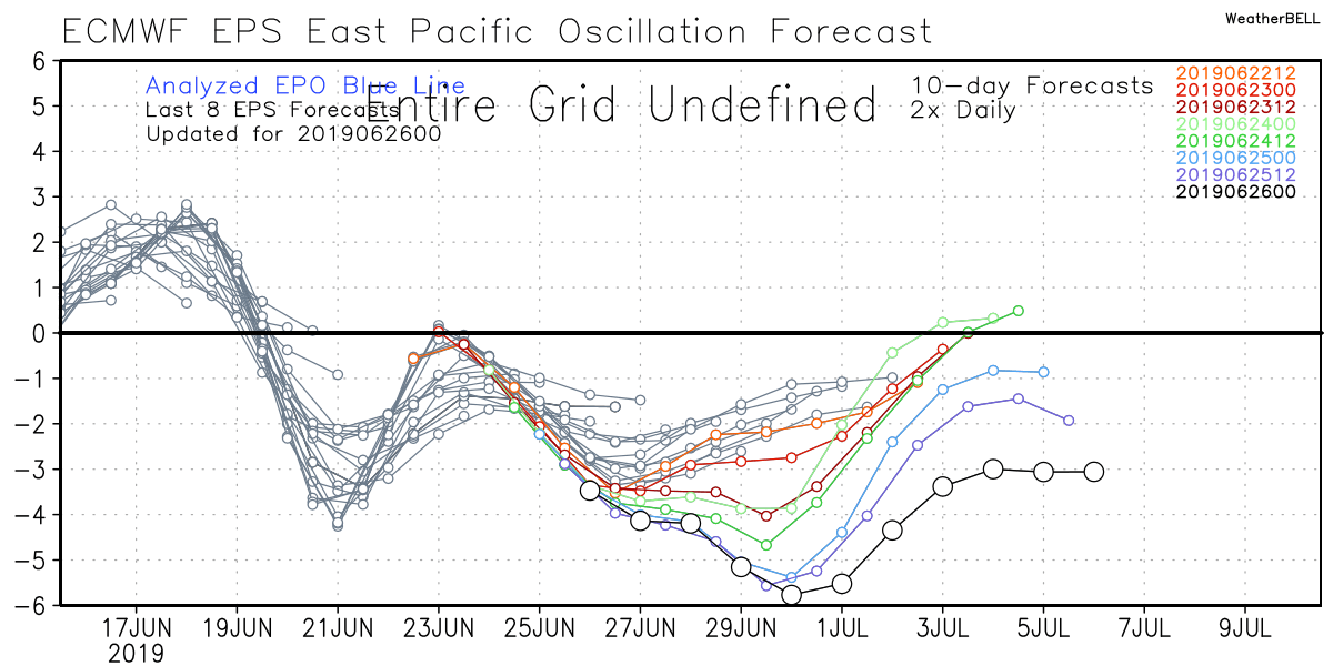
PNA

Looks like a cold shot possible warm up then a decently sustained period from the 3rdish until 10thish if the teles prove right. This would line up with the trop forcing and the MJO phase going into 8 this weekend

_________________
Mugs
AKA:King: Snow Weenie
Self Proclaimed
WINTER 2014-15 : 55.12" +.02 for 6 coatings (avg. 35")
WINTER 2015-16 Total - 29.8" (Avg 35")
WINTER 2016-17 : 39.5" so far
amugs- Advanced Forecaster - Mod
- Posts : 15091
Reputation : 213
Join date : 2013-01-07
Age : 54
Location : Hillsdale,NJ
Re: Long Range Thread 10.0
![]() by RJB8525 Tue Feb 23, 2016 10:50 am
by RJB8525 Tue Feb 23, 2016 10:50 am
CPcantmeasuresnow wrote:So no 40 inch snow storm in Orange County next week as per yesterdays GFS?
Well knock me over with a feather.


RJB8525- Senior Enthusiast
- Posts : 1994
Reputation : 28
Join date : 2013-02-06
Age : 38
Location : Hackettstown, NJ
Re: Long Range Thread 10.0
![]() by Math23x7 Tue Feb 23, 2016 12:35 pm
by Math23x7 Tue Feb 23, 2016 12:35 pm
Math23x7- Wx Statistician Guru
- Posts : 2379
Reputation : 68
Join date : 2013-01-08
Re: Long Range Thread 10.0
![]() by Guest Tue Feb 23, 2016 2:23 pm
by Guest Tue Feb 23, 2016 2:23 pm
syosnow94 wrote:GFS has a GLC on March 1st. Then 2 gigantic sub 990 bombs right on the BM. One on the 3rd and the other on the 9th. Canadian and Euro both have the first cutter than not so much after.
00Z GFS now shows the cutter on March 1st. The 2nd storm threat which was on the BM on March 3rd now is a cutter tracking over Detroit. (a 600 mile move west from one run to the next) and the storm threat for 3/9 trended west and disorganized. I know this far out it means almost nothing but it is actually comical!!
Guest- Guest
Page 27 of 28 • 1 ... 15 ... 26, 27, 28 ![]()
|
|
|