
 Search
Long Range Thread 10.0
Page 4 of 28 •  1, 2, 3, 4, 5 ... 16 ... 28
 ![]()
Re: Long Range Thread 10.0
![]() by amugs Mon Feb 01, 2016 12:18 pm
by amugs Mon Feb 01, 2016 12:18 pm
BTW Trop Tidbits


AND NO TEMPS ISSUE DISCUSSION THIS FAR OUT FOR CHRIST SAKE IT IS A WEEK AWAY!!!
amugs- Advanced Forecaster - Mod

- Posts : 15091
Join date : 2013-01-07
Re: Long Range Thread 10.0
![]() by algae888 Mon Feb 01, 2016 12:23 pm
by algae888 Mon Feb 01, 2016 12:23 pm
algae888- Advanced Forecaster

- Posts : 5311
Join date : 2013-02-05
Re: Long Range Thread 10.0
![]() by amugs Mon Feb 01, 2016 12:28 pm
by amugs Mon Feb 01, 2016 12:28 pm
algae888 wrote:mugs this whole winter cold outbreaks get muted as we get closer in time. my concern is how cold do we get. euro and gfs had -20 to-30 850's for us with this arctic air around feb 10th. models are now showing -10 to 0 for same time. expect it to get warmer as we get closer. doesn't mean we can't snow just won't be as cold as advertised a few days ago.
Al I hear you but it could easily go back to -12 C 850's as well. With a huge transition happening again the models will struggle. And for that the models had mix and rain on some runs 3 days before the blizzard with 850's sitting around 0*C so I am not and we should not look at this 1 week away just look at the pattern set up , there is a storm and that's what counts at this stage.
_________________
Mugs
AKA:King: Snow Weenie
Self Proclaimed
WINTER 2014-15 : 55.12" +.02 for 6 coatings (avg. 35")
WINTER 2015-16 Total - 29.8" (Avg 35")
WINTER 2016-17 : 39.5" so far

amugs- Advanced Forecaster - Mod
- Posts : 15091
Reputation : 213
Join date : 2013-01-07
Age : 54
Location : Hillsdale,NJ
Re: Long Range Thread 10.0
![]() by sroc4 Mon Feb 01, 2016 1:00 pm
by sroc4 Mon Feb 01, 2016 1:00 pm
algae888 wrote:mugs this whole winter cold outbreaks get muted as we get closer in time. my concern is how cold do we get. euro and gfs had -20 to-30 850's for us with this arctic air around feb 10th. models are now showing -10 to 0 for same time. expect it to get warmer as we get closer. doesn't mean we can't snow just won't be as cold as advertised a few days ago.
Al I feel like you need to re-examine what your priorities are going to be moving forward. An arctic outbreak and a storm set up should not be in the same convo when looking at if temps trend warmer or colder. From the storm standpoint, all we need is for the upper levels to be cold enough to support frozen, not wet. This far out looking at temp profiles for the storm is futile. I know you know that. However if you want to track the trends of the temps by all means. And I honestly mean no disrespect in that statement. I personally will not be judging this winter by how cold or warm it is. I look at snowfall in my back yard, plain and simple. I could care less if once the system moves through if the temps were forecast to get to -20 at 850mb, but they end up -8 in. I could care less if the surface Temp anomalies end up -8 or -1 or +2 for the month. If I end up with 50+" snowfall IMBY like I predicted, then we got our cold shots, and I win plain and simple. Would I prefer the storm and the sustained cold too. Hells yeah!! But with a strong el nino that expectation should not be the focus. There are other drivers in the equation, if verify like I think, should lead to additional and multiple cold shots and snow storm chances, and prevent the one and done type super nino years. And yes in betwen the cold shots may get warm, and yes the cold shot that looks like teens or twenties ends up 20's or thirties, again I dont care. As long as I get snow.
_________________
"In weather and in life, there's no winning and losing; there's only winning and learning."
WINTER 2012/2013 TOTALS 43.65"WINTER 2017/2018 TOTALS 62.85" WINTER 2022/2023 TOTALS 4.9"
WINTER 2013/2014 TOTALS 64.85"WINTER 2018/2019 TOTALS 14.25" WINTER 2023/2024 TOTALS 13.1"
WINTER 2014/2015 TOTALS 71.20"WINTER 2019/2020 TOTALS 6.35"
WINTER 2015/2016 TOTALS 35.00"WINTER 2020/2021 TOTALS 37.75"
WINTER 2016/2017 TOTALS 42.25"WINTER 2021/2022 TOTALS 31.65"

sroc4- Admin

- Posts : 8331
Reputation : 301
Join date : 2013-01-07
Location : Wading River, LI
Re: Long Range Thread 10.0
![]() by skinsfan1177 Mon Feb 01, 2016 1:13 pm
by skinsfan1177 Mon Feb 01, 2016 1:13 pm
Exactly the past blizzard we just had for me 3 days out was no and rain storm now we know what really happened got crushed. I was 32° for most of that storm. A week away so much can change and will.sroc4 wrote:algae888 wrote:mugs this whole winter cold outbreaks get muted as we get closer in time. my concern is how cold do we get. euro and gfs had -20 to-30 850's for us with this arctic air around feb 10th. models are now showing -10 to 0 for same time. expect it to get warmer as we get closer. doesn't mean we can't snow just won't be as cold as advertised a few days ago.
Al I feel like you need to re-examine what your priorities are going to be moving forward. An arctic outbreak and a storm set up should not be in the same convo when looking at if temps trend warmer or colder. From the storm standpoint, all we need is for the upper levels to be cold enough to support frozen, not wet. This far out looking at temp profiles for the storm is futile. I know you know that. However if you want to track the trends of the temps by all means. And I honestly mean no disrespect in that statement. I personally will not be judging this winter by how cold or warm it is. I look at snowfall in my back yard, plain and simple. I could care less if once the system moves through if the temps were forecast to get to -20 at 850mb, but they end up -8 in. I could care less if the surface Temp anomalies end up -8 or -1 or +2 for the month. If I end up with 50+" snowfall IMBY like I predicted, then we got our cold shots, and I win plain and simple. Would I prefer the storm and the sustained cold too. Hells yeah!! But with a strong el nino that expectation should not be the focus. There are other drivers in the equation, if verify like I think, should lead to additional and multiple cold shots and snow storm chances, and prevent the one and done type super nino years. And yes in betwen the cold shots may get warm, and yes the cold shot that looks like teens or twenties ends up 20's or thirties, again I dont care. As long as I get snow.

skinsfan1177- Senior Enthusiast

- Posts : 4485
Reputation : 35
Join date : 2013-01-07
Age : 46
Location : Point Pleasant Boro
Re: Long Range Thread 10.0
![]() by oldtimer Mon Feb 01, 2016 1:45 pm
by oldtimer Mon Feb 01, 2016 1:45 pm
oldtimer- Senior Enthusiast
- Posts : 1103
Reputation : 14
Join date : 2013-01-16
Age : 78
Location : Port Jefferson Station Suffolk County
Re: Long Range Thread 10.0
![]() by algae888 Mon Feb 01, 2016 3:01 pm
by algae888 Mon Feb 01, 2016 3:01 pm
scott my priorities? I guess i'm not seeing this winter returns scenario (heck did winter even start yet?) unless we are talking about temps in the mid 30's to low 40's for highs. I do not see the hype for the next 10 days or so (the first seven are way above normal). we have tracked one storm inside of seven days so far (ONE) and we still do not have a storm inside 7 days as I write this. tracking storms is what makes winter fun imo. not how many inches of snow we get. if we get one more 12" snowstorm and end up with 40" for the season is that a good winter? not in my book. esp with the warmth before, in between and after. the pattern was suppose to flip around jan 20th and then winter with a vengeance for the second half. well it flipped sooner and has gone right back to where December was and now we are waiting for some sort of miracle to salvage this winter. I guess it all comes down to perspective. anyway all mets and amateurs are going to end up right about this winter. top 5 warmest and snowier than normal. it's a win/win for all except this winter/snow weenie. all in fun. mother nature always has the last say.sroc4 wrote:algae888 wrote:mugs this whole winter cold outbreaks get muted as we get closer in time. my concern is how cold do we get. euro and gfs had -20 to-30 850's for us with this arctic air around feb 10th. models are now showing -10 to 0 for same time. expect it to get warmer as we get closer. doesn't mean we can't snow just won't be as cold as advertised a few days ago.
Al I feel like you need to re-examine what your priorities are going to be moving forward. An arctic outbreak and a storm set up should not be in the same convo when looking at if temps trend warmer or colder. From the storm standpoint, all we need is for the upper levels to be cold enough to support frozen, not wet. This far out looking at temp profiles for the storm is futile. I know you know that. However if you want to track the trends of the temps by all means. And I honestly mean no disrespect in that statement. I personally will not be judging this winter by how cold or warm it is. I look at snowfall in my back yard, plain and simple. I could care less if once the system moves through if the temps were forecast to get to -20 at 850mb, but they end up -8 in. I could care less if the surface Temp anomalies end up -8 or -1 or +2 for the month. If I end up with 50+" snowfall IMBY like I predicted, then we got our cold shots, and I win plain and simple. Would I prefer the storm and the sustained cold too. Hells yeah!! But with a strong el nino that expectation should not be the focus. There are other drivers in the equation, if verify like I think, should lead to additional and multiple cold shots and snow storm chances, and prevent the one and done type super nino years. And yes in betwen the cold shots may get warm, and yes the cold shot that looks like teens or twenties ends up 20's or thirties, again I dont care. As long as I get snow.

algae888- Advanced Forecaster
- Posts : 5311
Reputation : 46
Join date : 2013-02-05
Age : 61
Location : mt. vernon, new york
Re: Long Range Thread 10.0
![]() by sroc4 Mon Feb 01, 2016 3:24 pm
by sroc4 Mon Feb 01, 2016 3:24 pm
algae888 wrote:scott my priorities? I guess i'm not seeing this winter returns scenario (heck did winter even start yet?) unless we are talking about temps in the mid 30's to low 40's for highs. I do not see the hype for the next 10 days or so (the first seven are way above normal). we have tracked one storm inside of seven days so far (ONE) and we still do not have a storm inside 7 days as I write this. tracking storms is what makes winter fun imo. not how many inches of snow we get. if we get one more 12" snowstorm and end up with 40" for the season is that a good winter? not in my book. esp with the warmth before, in between and after. the pattern was suppose to flip around jan 20th and then winter with a vengeance for the second half. well it flipped sooner and has gone right back to where December was and now we are waiting for some sort of miracle to salvage this winter. I guess it all comes down to perspective. anyway all mets and amateurs are going to end up right about this winter. top 5 warmest and snowier than normal. it's a win/win for all except this winter/snow weenie. all in fun. mother nature always has the last say.sroc4 wrote:algae888 wrote:mugs this whole winter cold outbreaks get muted as we get closer in time. my concern is how cold do we get. euro and gfs had -20 to-30 850's for us with this arctic air around feb 10th. models are now showing -10 to 0 for same time. expect it to get warmer as we get closer. doesn't mean we can't snow just won't be as cold as advertised a few days ago.
Al I feel like you need to re-examine what your priorities are going to be moving forward. An arctic outbreak and a storm set up should not be in the same convo when looking at if temps trend warmer or colder. From the storm standpoint, all we need is for the upper levels to be cold enough to support frozen, not wet. This far out looking at temp profiles for the storm is futile. I know you know that. However if you want to track the trends of the temps by all means. And I honestly mean no disrespect in that statement. I personally will not be judging this winter by how cold or warm it is. I look at snowfall in my back yard, plain and simple. I could care less if once the system moves through if the temps were forecast to get to -20 at 850mb, but they end up -8 in. I could care less if the surface Temp anomalies end up -8 or -1 or +2 for the month. If I end up with 50+" snowfall IMBY like I predicted, then we got our cold shots, and I win plain and simple. Would I prefer the storm and the sustained cold too. Hells yeah!! But with a strong el nino that expectation should not be the focus. There are other drivers in the equation, if verify like I think, should lead to additional and multiple cold shots and snow storm chances, and prevent the one and done type super nino years. And yes in betwen the cold shots may get warm, and yes the cold shot that looks like teens or twenties ends up 20's or thirties, again I dont care. As long as I get snow.
Points well taken Al.
_________________
"In weather and in life, there's no winning and losing; there's only winning and learning."
WINTER 2012/2013 TOTALS 43.65"WINTER 2017/2018 TOTALS 62.85" WINTER 2022/2023 TOTALS 4.9"
WINTER 2013/2014 TOTALS 64.85"WINTER 2018/2019 TOTALS 14.25" WINTER 2023/2024 TOTALS 13.1"
WINTER 2014/2015 TOTALS 71.20"WINTER 2019/2020 TOTALS 6.35"
WINTER 2015/2016 TOTALS 35.00"WINTER 2020/2021 TOTALS 37.75"
WINTER 2016/2017 TOTALS 42.25"WINTER 2021/2022 TOTALS 31.65"
sroc4- Admin
- Posts : 8331
Reputation : 301
Join date : 2013-01-07
Location : Wading River, LI
Re: Long Range Thread 10.0
![]() by Guest Mon Feb 01, 2016 3:39 pm
by Guest Mon Feb 01, 2016 3:39 pm
Just a difference of perspectives. I personally loved the last 1/2 of last winter. Snow threats every few days and cold for 6 weeks. That's my idea of winter. (or 1996) Hopefully we get a good 5 weeks here starting Friday and then everyone's happy.
Guest- Guest
Re: Long Range Thread 10.0
![]() by amugs Mon Feb 01, 2016 3:43 pm
by amugs Mon Feb 01, 2016 3:43 pm


Phase 4 through 5 comers when the PV is flexing its muscle and the trop forcing is exerting itself so it gets washed out or muted/blocked. Phase 6 in Feb doesn't look bad to me by these maps that another met posted on another board., if we r going just the MJO pulse here.
_________________
Mugs
AKA:King: Snow Weenie
Self Proclaimed
WINTER 2014-15 : 55.12" +.02 for 6 coatings (avg. 35")
WINTER 2015-16 Total - 29.8" (Avg 35")
WINTER 2016-17 : 39.5" so far
amugs- Advanced Forecaster - Mod
- Posts : 15091
Reputation : 213
Join date : 2013-01-07
Age : 54
Location : Hillsdale,NJ
Re: Long Range Thread 10.0
![]() by amugs Mon Feb 01, 2016 3:48 pm
by amugs Mon Feb 01, 2016 3:48 pm
_________________
Mugs
AKA:King: Snow Weenie
Self Proclaimed
WINTER 2014-15 : 55.12" +.02 for 6 coatings (avg. 35")
WINTER 2015-16 Total - 29.8" (Avg 35")
WINTER 2016-17 : 39.5" so far
amugs- Advanced Forecaster - Mod
- Posts : 15091
Reputation : 213
Join date : 2013-01-07
Age : 54
Location : Hillsdale,NJ
Re: Long Range Thread 10.0
![]() by skinsfan1177 Mon Feb 01, 2016 3:58 pm
by skinsfan1177 Mon Feb 01, 2016 3:58 pm
skinsfan1177- Senior Enthusiast
- Posts : 4485
Reputation : 35
Join date : 2013-01-07
Age : 46
Location : Point Pleasant Boro
Re: Long Range Thread 10.0
![]() by Guest Mon Feb 01, 2016 5:12 pm
by Guest Mon Feb 01, 2016 5:12 pm
That being said 5 weeks of cold and 3 or 4 plow able storms and I will be over the moon and it sounds like this is possible.
Guest- Guest
Re: Long Range Thread 10.0
![]() by Frank_Wx Mon Feb 01, 2016 5:30 pm
by Frank_Wx Mon Feb 01, 2016 5:30 pm
syosnow94 wrote:I hope and trust that somethings coming. I don't think Jersey Shore Frankie would have put out such a positive MoMo if he wasn't confident we looked good going forward. My point is take out Jonas and the days leading up to it ( which was epic by the way) and this winter is the most disappointing and frustrating that I can remember in a long time.
That being said 5 weeks of cold and 3 or 4 plow able storms and I will be over the moon and it sounds like this is possible.
I think your expectations are / were too high for this winter. It's been mentioned numerous times by myself and others we're not going to get a whole lot of cold this winter. It's been expected that snowpack will hardly last a week since temperatures will rebound to above normal thanks to the active sub tropical jet induced by El Nino. Too much Pacific air is flooding the country this season. That said, February will be the coldest month but snow does not always follow cold. You still need things to go right with the pattern besides the cold.
_________________
_______________________________________________________________________________________________________
CLICK HERE to view NJ Strong Snowstorm Classifications

Frank_Wx- Godzilla Seeker
- Posts : 21305
Reputation : 328
Join date : 2013-01-05
Age : 31
Location : Jersey City, NJ -

Re: Long Range Thread 10.0
![]() by frank 638 Mon Feb 01, 2016 5:34 pm
by frank 638 Mon Feb 01, 2016 5:34 pm
frank 638- Senior Enthusiast
- Posts : 2823
Reputation : 37
Join date : 2016-01-01
Age : 40
Location : bronx ny
Re: Long Range Thread 10.0
![]() by Frank_Wx Mon Feb 01, 2016 5:39 pm
by Frank_Wx Mon Feb 01, 2016 5:39 pm
Next weeks storm threat highly favors the interior to see a good thump of snow while the coast deals with rain. Obviously this will change over the next few days - including the storm going out to sea all together - but here's why I favor the interior.

A piece of energy over the southeast is going to get captured by this huge trough diving into the central U.S. The ridge over the west coast is very impressive. A truly ++PNA linking with a cut-off ridge in the western Arcric. This is going to displace Arcric air in the North Pole and bring it southward into the CONUS. However, the axis of the trough is over the central U.S. instead of the eastern U.S. Too much upper energy digs on the backside of the trough which allows the Southeast ridge or Atlantic ridge to rise over the east coast.
This means the storm in the southeast has a good chance of taking a track up the coast instead of off the coast. The only way the coast snow is if the baroclinic zone shifts off the coast.

Perhaps in future model runs we see less energy digging on the backside which will allow the trough axis to be further east and the baroclinic zone to be off the coast. However, the anomalous ridging in the west may be too much of a good thing and this forces the trough over the Midwest and the southeast ridge to pump along the east coast.
Since we're dealing with a capture, this has a chance to also meander out to sea. If the trough is slower then the storm will ride the jet steam into the Atlantic. Still lots of time to watch this. A general 6-12 inches could fall from this for those in eastern PA, specifically NEPA, and the HV and maybe even NW NJ. But still lots of time.
_________________
_______________________________________________________________________________________________________
CLICK HERE to view NJ Strong Snowstorm Classifications
Frank_Wx- Godzilla Seeker
- Posts : 21305
Reputation : 328
Join date : 2013-01-05
Age : 31
Location : Jersey City, NJ -
Re: Long Range Thread 10.0
![]() by Frank_Wx Mon Feb 01, 2016 5:41 pm
by Frank_Wx Mon Feb 01, 2016 5:41 pm
frank 638 wrote:nick gregory said the pattern will change by next monday meaning colder and possible rain or snow on monday
Yes whatever happens February 8th-9th there is going to be an arctic blast that follows behind it. Possibly temps in the upper teens or 20s. VERY cold air. Once that cold relaxes, I think that's when we'll get our next significant snowstorm threat. So we're looking at February 14th-18th sometime.
_________________
_______________________________________________________________________________________________________
CLICK HERE to view NJ Strong Snowstorm Classifications
Frank_Wx- Godzilla Seeker
- Posts : 21305
Reputation : 328
Join date : 2013-01-05
Age : 31
Location : Jersey City, NJ -
Re: Long Range Thread 10.0
![]() by frank 638 Mon Feb 01, 2016 5:54 pm
by frank 638 Mon Feb 01, 2016 5:54 pm
frank 638- Senior Enthusiast
- Posts : 2823
Reputation : 37
Join date : 2016-01-01
Age : 40
Location : bronx ny
Re: Long Range Thread 10.0
![]() by Frank_Wx Mon Feb 01, 2016 5:55 pm
by Frank_Wx Mon Feb 01, 2016 5:55 pm
CPcantmeasuresnow wrote:I love your analysis as always Sroc but I just can't buy that the Strong El Nino was not the deciding factor in our warmest and I mean by far warmest December ever.
Is it just coincidence that the strongest El Nino ever, also saw the warmest December ever? A December that was 14 degrees above normal and 7 degrees above the second warmest December ever. No month has ever broken an old monthly record by 7 degrees, it's just unheard of.
As a layman who has always associated El Nino with mild and low snowfall Winters this is what I see so far. December record warmth and January 2 degrees above normal, check, with very few snow events basically one so far, check, and sometimes one huge event like 83, check. In my unscientific weather related mind this still looks to me like a winter and especially December that has been dominated by Hell Nino (to steal docstox's term).
Just my thoughts with no science to back it just observation.
On top of strong El Nino there were two other factors working against us in December.
1. Tropical forcing was over the eastern Nino regions. This promotes a NPAC trough centered over the west coast (-PNA). The west coast was very cold in December and when you have a -PNA coupled with an active STJ that will lead to record warmth for sure.
2. The QBO was very positive signaling the Strat PV was VERY strong so our AO was positive. Not only was the PNA negative and tropical forcing was unfavorable, we also had a dominating Strat PV bottling up all the cold in the North Pole. December was always a recipe for disaster and most forecasters pegged it to be a warm month. Just not THAT warm. Looking back, I can see why it turned out to be warm though.
sroc4 wrote:CPcantmeasuresnow wrote:I love your analysis as always Sroc but I just can't buy that the Strong El Nino was not the deciding factor in our warmest and I mean by far warmest December ever.
Is it just coincidence that the strongest El Nino ever, also saw the warmest December ever? A December that was 14 degrees above normal and 7 degrees above the second warmest December ever. No month has ever broken an old monthly record by 7 degrees, it's just unheard of.
As a layman who has always associated El Nino with mild and low snowfall Winters this is what I see so far. December record warmth and January 2 degrees above normal, check, with very few snow events basically one so far, check, and sometimes one huge event like 83, check. In my unscientific weather related mind this still looks to me like a winter and especially December that has been dominated by Hell Nino (to steal docstox's term).
Just my thoughts with no science to back it just observation.
Your points are valid CP; however, the MJO drove the car in Dec and the Nino reached over and pushed down on the gas pedal. Nino is what took our temp departures from warmer than normal to record warmer than normal. But Nino was not driving the car in that situation. IMHO. I dont not stand alone in that opinion either. Very educated professionals agree with that.
I'm not sure if the MJO played a strong role at any point this winter, but phase 5 and 6 December analogs during El Nino DO show warmth over the eastern U.S. You can see the -PNA too. Horrific setup if you're looking for cold on the east.

Point is, the writing was on the wall written in capital bold letters.
algae888 wrote:mugs this whole winter cold outbreaks get muted as we get closer in time. my concern is how cold do we get. euro and gfs had -20 to-30 850's for us with this arctic air around feb 10th. models are now showing -10 to 0 for same time. expect it to get warmer as we get closer. doesn't mean we can't snow just won't be as cold as advertised a few days ago.
I actually agree Al. Cold has been overstated on the models this year. That said, you have to look at the pattern at hand. At no point this season are we yet to see a -EPO, +PNA, -AO trio. We're potentially heading in that direction after February 8th. I definitely think we'll see our coldest temps this season and models probably won't be overstating BY MUCH
amugs wrote:Syo I wish we could have last winter with 95-96 rolled into one but we don't have that with an uber nino. As my sons Kindergarten teacher woudl say " you get what you get and you don't get upset!" last winter was great and so was the winter before. I can tell you this IF we get a weak nina for next winter things could be interesting.
La Niña isn't fun. Ugh.
_________________
_______________________________________________________________________________________________________
CLICK HERE to view NJ Strong Snowstorm Classifications
Frank_Wx- Godzilla Seeker
- Posts : 21305
Reputation : 328
Join date : 2013-01-05
Age : 31
Location : Jersey City, NJ -
Re: Long Range Thread 10.0
![]() by Frank_Wx Mon Feb 01, 2016 5:57 pm
by Frank_Wx Mon Feb 01, 2016 5:57 pm

_________________
_______________________________________________________________________________________________________
CLICK HERE to view NJ Strong Snowstorm Classifications
Frank_Wx- Godzilla Seeker
- Posts : 21305
Reputation : 328
Join date : 2013-01-05
Age : 31
Location : Jersey City, NJ -
Re: Long Range Thread 10.0
![]() by Frank_Wx Mon Feb 01, 2016 6:01 pm
by Frank_Wx Mon Feb 01, 2016 6:01 pm
_________________
_______________________________________________________________________________________________________
CLICK HERE to view NJ Strong Snowstorm Classifications
Frank_Wx- Godzilla Seeker
- Posts : 21305
Reputation : 328
Join date : 2013-01-05
Age : 31
Location : Jersey City, NJ -
Re: Long Range Thread 10.0
![]() by frank 638 Mon Feb 01, 2016 6:07 pm
by frank 638 Mon Feb 01, 2016 6:07 pm
frank 638- Senior Enthusiast
- Posts : 2823
Reputation : 37
Join date : 2016-01-01
Age : 40
Location : bronx ny
Re: Long Range Thread 10.0
![]() by Guest Mon Feb 01, 2016 6:14 pm
by Guest Mon Feb 01, 2016 6:14 pm
Guest- Guest
Re: Long Range Thread 10.0
![]() by devsman Mon Feb 01, 2016 7:17 pm
by devsman Mon Feb 01, 2016 7:17 pm
Frank_Wx wrote:All one has to do is loop the 18z GFS to see why I'm excited about February. A couple storm threats February 8th-11th before the brutal cold moves in. Then around the 15th we moderate and there may be another storm to track then. As cold relaxes, it usually is followed by a storm
Would be great if this was a redux of winter of 94 where it would rain then temp along the coast would drop to 20 and everything froze over. Ice skating on a football field will be one of my greatest memories.

devsman- Pro Enthusiast

- Posts : 424
Reputation : 4
Join date : 2014-01-01
Age : 48
Location : merrick, ny (south shore of Long Island)
Re: Long Range Thread 10.0
![]() by frank 638 Mon Feb 01, 2016 7:38 pm
by frank 638 Mon Feb 01, 2016 7:38 pm
frank 638- Senior Enthusiast
- Posts : 2823
Reputation : 37
Join date : 2016-01-01
Age : 40
Location : bronx ny
Re: Long Range Thread 10.0
![]() by amugs Mon Feb 01, 2016 9:56 pm
by amugs Mon Feb 01, 2016 9:56 pm
Nino 1.2: +1.0
Nino 3: +2.3
Nino 3.4: +2.5
Nino 4: +1.5
06JAN2016 25.7 1.8 28.1 2.7 29.1 2.6 29.7 1.4
13JAN2016 25.7 1.4 28.3 2.8 29.2 2.6 29.6 1.3
20JAN2016 26.0 1.4 28.2 2.5 29.1 2.5 29.6 1.4
27JAN2016 26.1 1.0 28.2 2.3 29.1 2.5 29.7 1.5
as compared to Trop Tidbits that has it at 1.5C and runs the SST over the NCEP readings by.3 to
4C for almost each reading data point

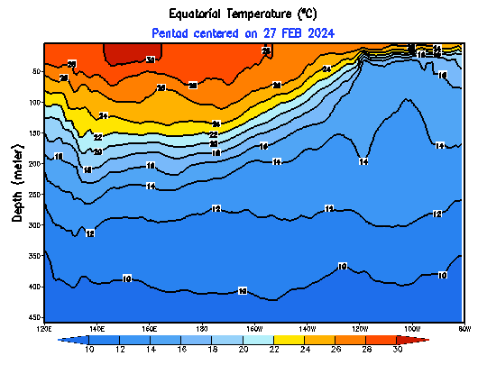
You look at the 7 day and the waters are cooling across the board in nino regions
[img]
 [/img]
Here is the depth of teh warm waters as well - look at how it is shallow and it rapidly cooled in the east regions to the right of the the animation.
_________________
Mugs
AKA:King: Snow Weenie
Self Proclaimed
WINTER 2014-15 : 55.12" +.02 for 6 coatings (avg. 35")
WINTER 2015-16 Total - 29.8" (Avg 35")
WINTER 2016-17 : 39.5" so far
amugs- Advanced Forecaster - Mod
- Posts : 15091
Reputation : 213
Join date : 2013-01-07
Age : 54
Location : Hillsdale,NJ
Re: Long Range Thread 10.0
![]() by Snow88 Mon Feb 01, 2016 11:24 pm
by Snow88 Mon Feb 01, 2016 11:24 pm

Snow88- Senior Enthusiast
- Posts : 2193
Reputation : 4
Join date : 2013-01-09
Age : 35
Location : Brooklyn, NY
Page 4 of 28 • 1, 2, 3, 4, 5 ... 16 ... 28 ![]()
|
|
|