
 Search
03/04 Minor Snow Event
Page 1 of 4 • 1, 2, 3, 4 ![]()

03/04 Minor Snow Event
![]() by Frank_Wx Tue Mar 01, 2016 10:45 am
by Frank_Wx Tue Mar 01, 2016 10:45 am
Latest NAM snow map

_________________
_______________________________________________________________________________________________________
CLICK HERE to view NJ Strong Snowstorm Classifications

Frank_Wx- Godzilla Seeker

- Posts : 21305
Reputation : 328
Join date : 2013-01-05
Age : 31
Location : Jersey City, NJ -

Re: 03/04 Minor Snow Event
![]() by Frank_Wx Tue Mar 01, 2016 10:51 am
by Frank_Wx Tue Mar 01, 2016 10:51 am

_________________
_______________________________________________________________________________________________________
CLICK HERE to view NJ Strong Snowstorm Classifications
Frank_Wx- Godzilla Seeker
- Posts : 21305
Reputation : 328
Join date : 2013-01-05
Age : 31
Location : Jersey City, NJ -
Re: 03/04 Minor Snow Event
![]() by amugs Tue Mar 01, 2016 10:58 am
by amugs Tue Mar 01, 2016 10:58 am

_________________
Mugs
AKA:King: Snow Weenie
Self Proclaimed
WINTER 2014-15 : 55.12" +.02 for 6 coatings (avg. 35")
WINTER 2015-16 Total - 29.8" (Avg 35")
WINTER 2016-17 : 39.5" so far

amugs- Advanced Forecaster - Mod

- Posts : 15091
Reputation : 213
Join date : 2013-01-07
Age : 54
Location : Hillsdale,NJ
Re: 03/04 Minor Snow Event
![]() by Frank_Wx Tue Mar 01, 2016 10:59 am
by Frank_Wx Tue Mar 01, 2016 10:59 am
_________________
_______________________________________________________________________________________________________
CLICK HERE to view NJ Strong Snowstorm Classifications
Frank_Wx- Godzilla Seeker
- Posts : 21305
Reputation : 328
Join date : 2013-01-05
Age : 31
Location : Jersey City, NJ -
Re: 03/04 Minor Snow Event
![]() by Frank_Wx Tue Mar 01, 2016 11:00 am
by Frank_Wx Tue Mar 01, 2016 11:00 am
_________________
_______________________________________________________________________________________________________
CLICK HERE to view NJ Strong Snowstorm Classifications
Frank_Wx- Godzilla Seeker
- Posts : 21305
Reputation : 328
Join date : 2013-01-05
Age : 31
Location : Jersey City, NJ -
Re: 03/04 Minor Snow Event
![]() by amugs Tue Mar 01, 2016 11:01 am
by amugs Tue Mar 01, 2016 11:01 am

_________________
Mugs
AKA:King: Snow Weenie
Self Proclaimed
WINTER 2014-15 : 55.12" +.02 for 6 coatings (avg. 35")
WINTER 2015-16 Total - 29.8" (Avg 35")
WINTER 2016-17 : 39.5" so far
amugs- Advanced Forecaster - Mod
- Posts : 15091
Reputation : 213
Join date : 2013-01-07
Age : 54
Location : Hillsdale,NJ
Re: 03/04 Minor Snow Event
![]() by amugs Tue Mar 01, 2016 11:02 am
by amugs Tue Mar 01, 2016 11:02 am

_________________
Mugs
AKA:King: Snow Weenie
Self Proclaimed
WINTER 2014-15 : 55.12" +.02 for 6 coatings (avg. 35")
WINTER 2015-16 Total - 29.8" (Avg 35")
WINTER 2016-17 : 39.5" so far
amugs- Advanced Forecaster - Mod
- Posts : 15091
Reputation : 213
Join date : 2013-01-07
Age : 54
Location : Hillsdale,NJ
Re: 03/04 Minor Snow Event
![]() by amugs Tue Mar 01, 2016 11:03 am
by amugs Tue Mar 01, 2016 11:03 am
_________________
Mugs
AKA:King: Snow Weenie
Self Proclaimed
WINTER 2014-15 : 55.12" +.02 for 6 coatings (avg. 35")
WINTER 2015-16 Total - 29.8" (Avg 35")
WINTER 2016-17 : 39.5" so far
amugs- Advanced Forecaster - Mod
- Posts : 15091
Reputation : 213
Join date : 2013-01-07
Age : 54
Location : Hillsdale,NJ
Re: 03/04 Minor Snow Event
![]() by nutleyblizzard Tue Mar 01, 2016 11:34 am
by nutleyblizzard Tue Mar 01, 2016 11:34 am

nutleyblizzard- Senior Enthusiast

- Posts : 1952
Reputation : 41
Join date : 2014-01-30
Age : 57
Location : Nutley, new jersey
Re: 03/04 Minor Snow Event
![]() by amugs Tue Mar 01, 2016 11:58 am
by amugs Tue Mar 01, 2016 11:58 am
Never write off the last hurrah, this ain't done trending NW imho. The HP is modelled as of now to exit quicker allowing fir this to turn more N, need a full phase earlier and we see a good solid snowstorm that we can then end this winter on.
_________________
Mugs
AKA:King: Snow Weenie
Self Proclaimed
WINTER 2014-15 : 55.12" +.02 for 6 coatings (avg. 35")
WINTER 2015-16 Total - 29.8" (Avg 35")
WINTER 2016-17 : 39.5" so far
amugs- Advanced Forecaster - Mod
- Posts : 15091
Reputation : 213
Join date : 2013-01-07
Age : 54
Location : Hillsdale,NJ
Re: 03/04 Minor Snow Event
![]() by sroc4 Tue Mar 01, 2016 12:55 pm
by sroc4 Tue Mar 01, 2016 12:55 pm

_________________
"In weather and in life, there's no winning and losing; there's only winning and learning."
WINTER 2012/2013 TOTALS 43.65"WINTER 2017/2018 TOTALS 62.85" WINTER 2022/2023 TOTALS 4.9"
WINTER 2013/2014 TOTALS 64.85"WINTER 2018/2019 TOTALS 14.25" WINTER 2023/2024 TOTALS 13.1"
WINTER 2014/2015 TOTALS 71.20"WINTER 2019/2020 TOTALS 6.35"
WINTER 2015/2016 TOTALS 35.00"WINTER 2020/2021 TOTALS 37.75"
WINTER 2016/2017 TOTALS 42.25"WINTER 2021/2022 TOTALS 31.65"

sroc4- Admin
- Posts : 8331
Reputation : 301
Join date : 2013-01-07
Location : Wading River, LI
Re: 03/04 Minor Snow Event
![]() by amugs Tue Mar 01, 2016 1:24 pm
by amugs Tue Mar 01, 2016 1:24 pm
_________________
Mugs
AKA:King: Snow Weenie
Self Proclaimed
WINTER 2014-15 : 55.12" +.02 for 6 coatings (avg. 35")
WINTER 2015-16 Total - 29.8" (Avg 35")
WINTER 2016-17 : 39.5" so far
amugs- Advanced Forecaster - Mod
- Posts : 15091
Reputation : 213
Join date : 2013-01-07
Age : 54
Location : Hillsdale,NJ
Re: 03/04 Minor Snow Event
![]() by Frank_Wx Tue Mar 01, 2016 1:31 pm
by Frank_Wx Tue Mar 01, 2016 1:31 pm
_________________
_______________________________________________________________________________________________________
CLICK HERE to view NJ Strong Snowstorm Classifications
Frank_Wx- Godzilla Seeker
- Posts : 21305
Reputation : 328
Join date : 2013-01-05
Age : 31
Location : Jersey City, NJ -
Re: 03/04 Minor Snow Event
![]() by sroc4 Tue Mar 01, 2016 2:13 pm
by sroc4 Tue Mar 01, 2016 2:13 pm
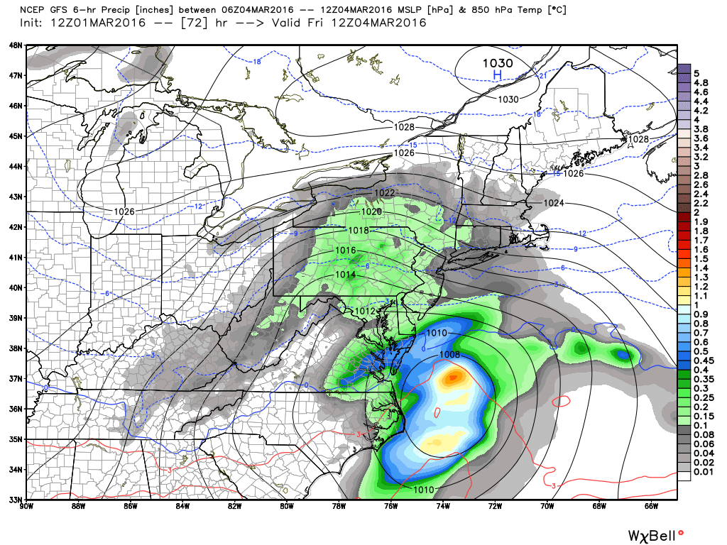
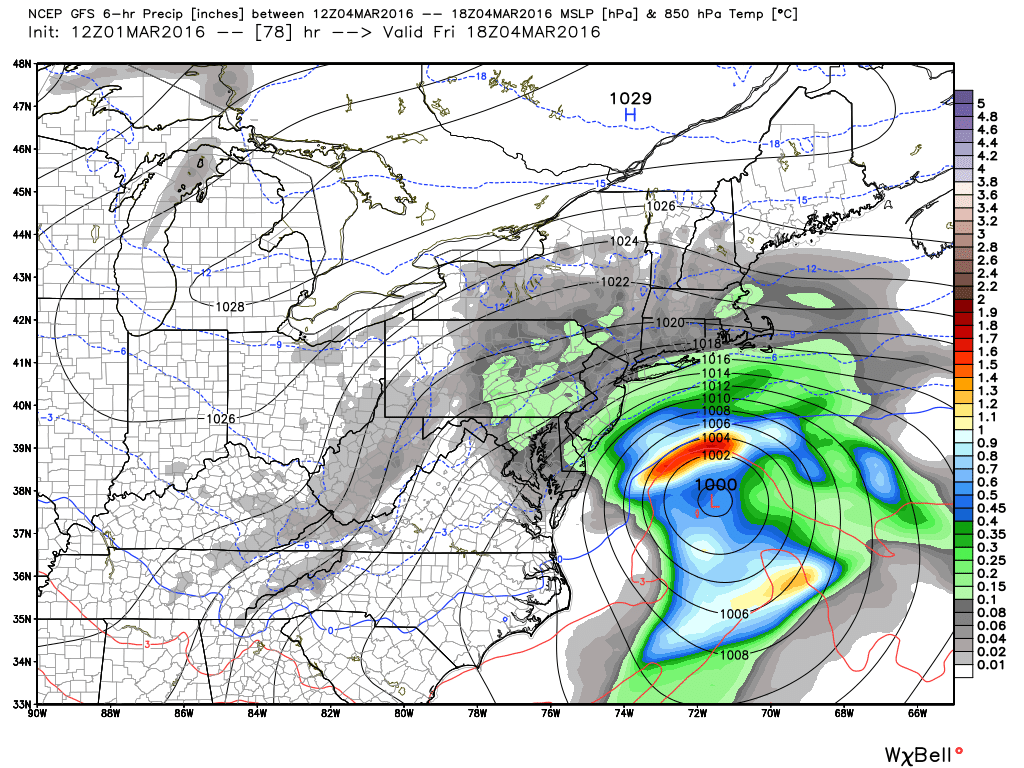
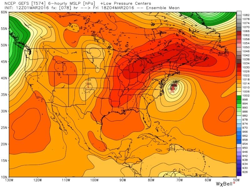
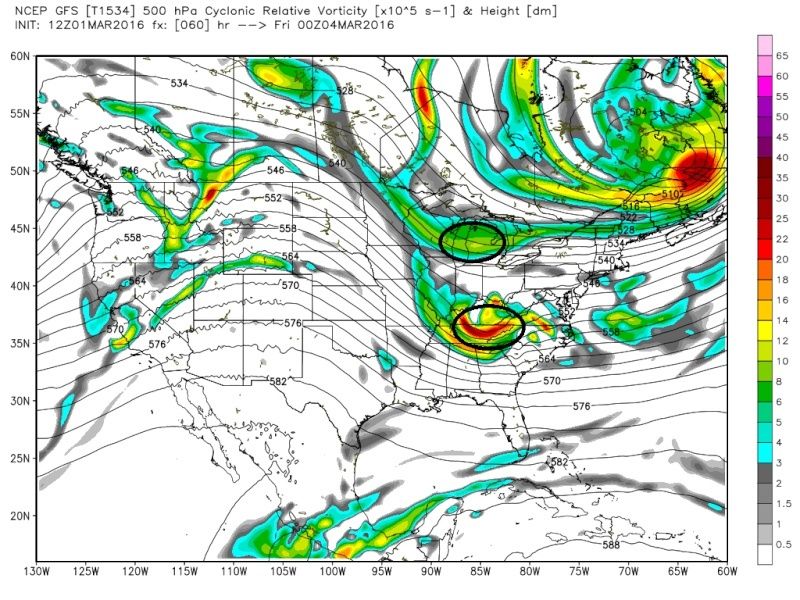
Notice on the GFS the southern piece is out ahead of the N piece, whereas, the N piece is slight ahead of the S piece on the Euro, and also the S piece is further N on the GFS compared to the Euro. This little difference makes all the difference in the world. If the Euro is right then the N piece will likely push the S piece and keep the track OTS, if the GFS is right then there is room for the southern energy to be pulled north via phasing(if timing of any phasing is right) with the N energy; therefore, room for the LP to track more N instead of east.
GFS:

Euro:
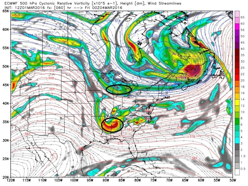

Notice on the second images of both models the main focus of vorticity (areas where the red is) in the southern branch. The GFS has it centered just off the coast just S of the Delmarva; whereas the Euro has it just off the N Carolina/S Carolina coast. A huge difference on our sensible weather, depending on which model has the right idea. The strength of Northern piece, and how far south it can dig is important in all of this as well.
Bottom line is it would not take much at all at 500mb on either model, esp if the GFS is more right on timing/ positioning, and strength of the two energies, for a more moderate or even significant event to unfold. So which one do I think is right? Well GFS has had a progressive bias historically, but I cant recall if its with N energies or S energies. If its the latter then one would think that the southern energy is too far out ahead on the 12z and will correct slower and trend further S and OTS with the track. However if its the former(Northen progressive bias on the GFS) then it may be onto something, because historically the Euro bias is to hold back energy in the southern branch, soooo in theory when the energy involved comes ashore tonight we could see the euro correct some with the southern energy with it trending a tad faster as we get into the next 24-48hrs of model runs, and therefore bring the track further N. My logical mind says that this will most likely end up so close yet so F---ing far away, but the weenie in me, wait...that sounded weird, the Snow weenie in me, wait...still weird, there still is a sound scientific reasoning and room for a more moderate to significant event to unfold; the answers of which should be determined within the next 24-48hrs as all of the energy is better sampled. No matter how it unfolds it gonna get warm up in here next week.
_________________
"In weather and in life, there's no winning and losing; there's only winning and learning."
WINTER 2012/2013 TOTALS 43.65"WINTER 2017/2018 TOTALS 62.85" WINTER 2022/2023 TOTALS 4.9"
WINTER 2013/2014 TOTALS 64.85"WINTER 2018/2019 TOTALS 14.25" WINTER 2023/2024 TOTALS 13.1"
WINTER 2014/2015 TOTALS 71.20"WINTER 2019/2020 TOTALS 6.35"
WINTER 2015/2016 TOTALS 35.00"WINTER 2020/2021 TOTALS 37.75"
WINTER 2016/2017 TOTALS 42.25"WINTER 2021/2022 TOTALS 31.65"
sroc4- Admin
- Posts : 8331
Reputation : 301
Join date : 2013-01-07
Location : Wading River, LI
Re: 03/04 Minor Snow Event
![]() by algae888 Tue Mar 01, 2016 3:20 pm
by algae888 Tue Mar 01, 2016 3:20 pm

algae888- Advanced Forecaster

- Posts : 5311
Reputation : 46
Join date : 2013-02-05
Age : 61
Location : mt. vernon, new york
Re: 03/04 Minor Snow Event
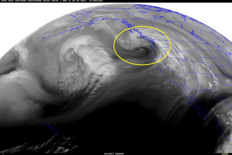
![]() by sroc4 Tue Mar 01, 2016 4:04 pm
by sroc4 Tue Mar 01, 2016 4:04 pm
http://mapmaker.aos.wisc.edu/scr3/sat/west/westwvflash.html
_________________
"In weather and in life, there's no winning and losing; there's only winning and learning."
WINTER 2012/2013 TOTALS 43.65"WINTER 2017/2018 TOTALS 62.85" WINTER 2022/2023 TOTALS 4.9"
WINTER 2013/2014 TOTALS 64.85"WINTER 2018/2019 TOTALS 14.25" WINTER 2023/2024 TOTALS 13.1"
WINTER 2014/2015 TOTALS 71.20"WINTER 2019/2020 TOTALS 6.35"
WINTER 2015/2016 TOTALS 35.00"WINTER 2020/2021 TOTALS 37.75"
WINTER 2016/2017 TOTALS 42.25"WINTER 2021/2022 TOTALS 31.65"
sroc4- Admin
- Posts : 8331
Reputation : 301
Join date : 2013-01-07
Location : Wading River, LI
Re: 03/04 Minor Snow Event
![]() by Frank_Wx Tue Mar 01, 2016 5:57 pm
by Frank_Wx Tue Mar 01, 2016 5:57 pm

_________________
_______________________________________________________________________________________________________
CLICK HERE to view NJ Strong Snowstorm Classifications
Frank_Wx- Godzilla Seeker
- Posts : 21305
Reputation : 328
Join date : 2013-01-05
Age : 31
Location : Jersey City, NJ -
Re: 03/04 Minor Snow Event
![]() by jake732 Tue Mar 01, 2016 6:07 pm
by jake732 Tue Mar 01, 2016 6:07 pm

jake732- Pro Enthusiast

- Posts : 449
Reputation : 0
Join date : 2016-01-03
Location : lakewood, nj -
Re: 03/04 Minor Snow Event
![]() by Frank_Wx Tue Mar 01, 2016 6:26 pm
by Frank_Wx Tue Mar 01, 2016 6:26 pm
jake732 wrote:Frank, I guess it won't be coming North? When do the short range models start because Im wondering what they will show
The NAM looks like the GFS. I honestly don't think we'll see a coastal come up the coast. I think this will remain a minor event. That said, the GEFS keep trending so we won't know for sure until tomorrow most likely.
_________________
_______________________________________________________________________________________________________
CLICK HERE to view NJ Strong Snowstorm Classifications
Frank_Wx- Godzilla Seeker
- Posts : 21305
Reputation : 328
Join date : 2013-01-05
Age : 31
Location : Jersey City, NJ -
Re: 03/04 Minor Snow Event
![]() by amugs Tue Mar 01, 2016 6:30 pm
by amugs Tue Mar 01, 2016 6:30 pm
.5 TO .75 UP TO NYC
_________________
Mugs
AKA:King: Snow Weenie
Self Proclaimed
WINTER 2014-15 : 55.12" +.02 for 6 coatings (avg. 35")
WINTER 2015-16 Total - 29.8" (Avg 35")
WINTER 2016-17 : 39.5" so far
amugs- Advanced Forecaster - Mod
- Posts : 15091
Reputation : 213
Join date : 2013-01-07
Age : 54
Location : Hillsdale,NJ
Re: 03/04 Minor Snow Event
![]() by amugs Tue Mar 01, 2016 6:32 pm
by amugs Tue Mar 01, 2016 6:32 pm

_________________
Mugs
AKA:King: Snow Weenie
Self Proclaimed
WINTER 2014-15 : 55.12" +.02 for 6 coatings (avg. 35")
WINTER 2015-16 Total - 29.8" (Avg 35")
WINTER 2016-17 : 39.5" so far
amugs- Advanced Forecaster - Mod
- Posts : 15091
Reputation : 213
Join date : 2013-01-07
Age : 54
Location : Hillsdale,NJ
Re: 03/04 Minor Snow Event
![]() by dkodgis Tue Mar 01, 2016 8:59 pm
by dkodgis Tue Mar 01, 2016 8:59 pm

dkodgis- Senior Enthusiast
- Posts : 2492
Reputation : 98
Join date : 2013-12-29
Re: 03/04 Minor Snow Event
![]() by Frank_Wx Tue Mar 01, 2016 10:59 pm
by Frank_Wx Tue Mar 01, 2016 10:59 pm

_________________
_______________________________________________________________________________________________________
CLICK HERE to view NJ Strong Snowstorm Classifications
Frank_Wx- Godzilla Seeker
- Posts : 21305
Reputation : 328
Join date : 2013-01-05
Age : 31
Location : Jersey City, NJ -

Snow88- Senior Enthusiast
- Posts : 2193
Reputation : 4
Join date : 2013-01-09
Age : 35
Location : Brooklyn, NY
Re: 03/04 Minor Snow Event
![]() by nutleyblizzard Wed Mar 02, 2016 6:21 am
by nutleyblizzard Wed Mar 02, 2016 6:21 am
nutleyblizzard- Senior Enthusiast
- Posts : 1952
Reputation : 41
Join date : 2014-01-30
Age : 57
Location : Nutley, new jersey
Page 1 of 4 • 1, 2, 3, 4 ![]()
|
|
|