
 Search
7/29-7/31 Possible Heavy Rain Event Disco/Obs.
Page 1 of 3 • 1, 2, 3 ![]()

7/29-7/31 Possible Heavy Rain Event Disco/Obs.
![]() by snow247 Thu Jul 28, 2016 12:54 pm
by snow247 Thu Jul 28, 2016 12:54 pm


snow247- Pro Enthusiast

- Posts : 2417
Reputation : 0
Join date : 2014-08-27
Location : Mount Ivy, NY - Elevation 545'
Re: 7/29-7/31 Possible Heavy Rain Event Disco/Obs.
![]() by jmanley32 Thu Jul 28, 2016 1:06 pm
by jmanley32 Thu Jul 28, 2016 1:06 pm

jmanley32- Senior Enthusiast

- Posts : 20512
Reputation : 108
Join date : 2013-12-12
Age : 42
Location : Yonkers, NY
Re: 7/29-7/31 Possible Heavy Rain Event Disco/Obs.
![]() by skinsfan1177 Thu Jul 28, 2016 1:26 pm
by skinsfan1177 Thu Jul 28, 2016 1:26 pm

skinsfan1177- Senior Enthusiast
- Posts : 4485
Reputation : 35
Join date : 2013-01-07
Age : 46
Location : Point Pleasant Boro
Re: 7/29-7/31 Possible Heavy Rain Event Disco/Obs.
![]() by Frank_Wx Thu Jul 28, 2016 1:27 pm
by Frank_Wx Thu Jul 28, 2016 1:27 pm
_________________
_______________________________________________________________________________________________________
CLICK HERE to view NJ Strong Snowstorm Classifications

Frank_Wx- Godzilla Seeker

- Posts : 21305
Reputation : 328
Join date : 2013-01-05
Age : 31
Location : Jersey City, NJ -

Re: 7/29-7/31 Possible Heavy Rain Event Disco/Obs.
![]() by jmanley32 Thu Jul 28, 2016 1:30 pm
by jmanley32 Thu Jul 28, 2016 1:30 pm
jmanley32- Senior Enthusiast
- Posts : 20512
Reputation : 108
Join date : 2013-12-12
Age : 42
Location : Yonkers, NY
Re: 7/29-7/31 Possible Heavy Rain Event Disco/Obs.
![]() by jmanley32 Thu Jul 28, 2016 1:31 pm
by jmanley32 Thu Jul 28, 2016 1:31 pm
Frank_Wx wrote:I am more upset about the weekend. Clouds and rain Saturday and Sunday.
From I read Sat is going be to sunny and 86 per all sources I have seen. Sunday yes I heard rain.
jmanley32- Senior Enthusiast
- Posts : 20512
Reputation : 108
Join date : 2013-12-12
Age : 42
Location : Yonkers, NY
Re: 7/29-7/31 Possible Heavy Rain Event Disco/Obs.
![]() by amugs Thu Jul 28, 2016 1:54 pm
by amugs Thu Jul 28, 2016 1:54 pm
Some areas may have to get out the ark with the latest runs. Rain looks to come in after midnight and be out by noonish tomorrow and then another round Sunday during the day - this is much needed for our drought watch.
_________________
Mugs
AKA:King: Snow Weenie
Self Proclaimed
WINTER 2014-15 : 55.12" +.02 for 6 coatings (avg. 35")
WINTER 2015-16 Total - 29.8" (Avg 35")
WINTER 2016-17 : 39.5" so far

amugs- Advanced Forecaster - Mod

- Posts : 15093
Reputation : 213
Join date : 2013-01-07
Age : 54
Location : Hillsdale,NJ
Re: 7/29-7/31 Possible Heavy Rain Event Disco/Obs.
![]() by skinsfan1177 Thu Jul 28, 2016 2:39 pm
by skinsfan1177 Thu Jul 28, 2016 2:39 pm
skinsfan1177- Senior Enthusiast
- Posts : 4485
Reputation : 35
Join date : 2013-01-07
Age : 46
Location : Point Pleasant Boro
Re: 7/29-7/31 Possible Heavy Rain Event Disco/Obs.
![]() by weatherwatchermom Thu Jul 28, 2016 2:42 pm
by weatherwatchermom Thu Jul 28, 2016 2:42 pm
Frank_Wx wrote:I am more upset about the weekend. Clouds and rain Saturday and Sunday.
I thought Saturday was supposed to be nice...did that change?

weatherwatchermom- Senior Enthusiast
- Posts : 3733
Reputation : 77
Join date : 2014-11-25
Age : 60
Location : Hazlet Township, NJ
Re: 7/29-7/31 Possible Heavy Rain Event Disco/Obs.
![]() by jmanley32 Thu Jul 28, 2016 2:46 pm
by jmanley32 Thu Jul 28, 2016 2:46 pm
jmanley32- Senior Enthusiast
- Posts : 20512
Reputation : 108
Join date : 2013-12-12
Age : 42
Location : Yonkers, NY
Re: 7/29-7/31 Possible Heavy Rain Event Disco/Obs.
![]() by snow247 Thu Jul 28, 2016 2:47 pm
by snow247 Thu Jul 28, 2016 2:47 pm
...FLASH FLOOD WATCH IN EFFECT FROM 8 PM EDT THIS EVENING THROUGH
FRIDAY AFTERNOON...
THE NATIONAL WEATHER SERVICE IN UPTON HAS ISSUED A
* FLASH FLOOD WATCH FOR PORTIONS OF SOUTHERN CONNECTICUT...
NORTHEAST NEW JERSEY AND SOUTHEAST NEW YORK...INCLUDING THE
FOLLOWING AREAS...IN SOUTHERN CONNECTICUT...NORTHERN
FAIRFIELD...NORTHERN MIDDLESEX...NORTHERN NEW HAVEN...NORTHERN
NEW LONDON...SOUTHERN FAIRFIELD...SOUTHERN MIDDLESEX...
SOUTHERN NEW HAVEN AND SOUTHERN NEW LONDON. IN NORTHEAST NEW
JERSEY...EASTERN BERGEN...EASTERN ESSEX...EASTERN PASSAIC...
EASTERN UNION...HUDSON...WESTERN BERGEN...WESTERN ESSEX...
WESTERN PASSAIC AND WESTERN UNION. IN SOUTHEAST NEW YORK...
BRONX...KINGS (BROOKLYN)...NEW YORK (MANHATTAN)...NORTHEASTERN
SUFFOLK...NORTHERN NASSAU...NORTHERN QUEENS...NORTHERN
WESTCHESTER...NORTHWESTERN SUFFOLK...ORANGE...PUTNAM...
RICHMOND (STATEN ISLAND)...ROCKLAND...SOUTHEASTERN SUFFOLK...
SOUTHERN NASSAU...SOUTHERN QUEENS...SOUTHERN WESTCHESTER AND
SOUTHWESTERN SUFFOLK.
* FROM 8 PM EDT THIS EVENING THROUGH FRIDAY AFTERNOON
* SHOWERS AND THUNDERSTORMS WILL BE MOVING INTO THE REGION FROM
THE WEST EARLY THIS EVENING AND WILL OVERSPREAD THE REGION BY
LATE TONIGHT. SHOWERS AND THUNDERSTORMS WILL CONTINUE INTO
FRIDAY MORNING AND BEGIN TO TAPER OFF FROM WEST TO EAST DURING
FRIDAY AFTERNOON. THERE IS THE POTENTIAL FOR PERIODS OF HEAVY
RAINFALL THIS EVENING INTO FRIDAY AFTERNOON.
* THE AXIS OF HEAVIEST RAIN REMAINS UNCERTAIN. HOWEVER...AT THIS
TIME THE HEAVIEST RAIN IS FORECAST TO EXTEND FROM NORTHEASTERN
NEW JERSEY INTO THE LOWER HUDSON VALLEY...NEW YORK CITY...AND
SOUTHERN CONNECTICUT. RAINFALL TOTALS OF 2 TO 4 INCHES ARE
POSSIBLE...WITH LOCALIZED HIGHER AMOUNTS POSSIBLE. THE MAIN
THREAT IS FLASH FLOODING OF LOW LYING...POOR DRAINAGE...AND
URBANIZED AREAS. SMALLER FLASHIER STREAMS MAY ALSO FLOOD.
snow247- Pro Enthusiast
- Posts : 2417
Reputation : 0
Join date : 2014-08-27
Location : Mount Ivy, NY - Elevation 545'
Re: 7/29-7/31 Possible Heavy Rain Event Disco/Obs.
![]() by skinsfan1177 Thu Jul 28, 2016 3:34 pm
by skinsfan1177 Thu Jul 28, 2016 3:34 pm

Rain coming in already snj and cnj
skinsfan1177- Senior Enthusiast
- Posts : 4485
Reputation : 35
Join date : 2013-01-07
Age : 46
Location : Point Pleasant Boro
Re: 7/29-7/31 Possible Heavy Rain Event Disco/Obs.
![]() by dkodgis Thu Jul 28, 2016 3:53 pm
by dkodgis Thu Jul 28, 2016 3:53 pm

dkodgis- Senior Enthusiast
- Posts : 2493
Reputation : 98
Join date : 2013-12-29
Re: 7/29-7/31 Possible Heavy Rain Event Disco/Obs.
![]() by jmanley32 Thu Jul 28, 2016 4:13 pm
by jmanley32 Thu Jul 28, 2016 4:13 pm
dkodgis wrote:Here in northern Orange County at 3:50 pm it is already getting dark. Near exit 36 on the parkway I have another house and they tell me it is pouring there. Tuesday morning there was a microburst that snapped a tree that fell on the side of the house. The elec lines took most of the tree. About $350 later in roof repairs, and then cutting up the tree after the elec company removed the part that was on the lines, I am so happy the roof is secure based on these insane rain totals. I had one eye on the chainsaw and the other on the forecast!
Wow that stinks sorry you had damage. Never been a home owner but buy my parents have had their fair share of tree cleanup costs and one big damage when a termite ridden tree (huge) fell on the garage crushing and puncturing the garage all the way to the inside. I think all together with the tree cleanup and repair to whole roof must been around 5k. Sandy tree cleanup cost them 3200.
jmanley32- Senior Enthusiast
- Posts : 20512
Reputation : 108
Join date : 2013-12-12
Age : 42
Location : Yonkers, NY
Re: 7/29-7/31 Possible Heavy Rain Event Disco/Obs.
![]() by jmanley32 Thu Jul 28, 2016 4:33 pm
by jmanley32 Thu Jul 28, 2016 4:33 pm
Tonight: A chance of showers and thunderstorms, then showers and possibly a thunderstorm after 11pm. Some of the storms could produce heavy rain. Low around 73. South wind 6 to 11 mph becoming light and variable in the evening. Chance of precipitation is 80%. New rainfall amounts between 1 and 2 inches possible.
Friday: Showers and possibly a thunderstorm before 2pm, then a slight chance of showers. Some of the storms could produce heavy rain. High near 80. East wind 9 to 14 mph becoming north in the morning. Chance of precipitation is 90%. New rainfall amounts between 1 and 2 inches possible.
jmanley32- Senior Enthusiast
- Posts : 20512
Reputation : 108
Join date : 2013-12-12
Age : 42
Location : Yonkers, NY
Re: 7/29-7/31 Possible Heavy Rain Event Disco/Obs.
![]() by jmanley32 Thu Jul 28, 2016 4:36 pm
by jmanley32 Thu Jul 28, 2016 4:36 pm
.NEAR TERM /UNTIL 6 AM FRIDAY MORNING/...
A coastal trough remains along with a deepening low over
Virginia. This low is associated with the vigorous shortwave
moving through the northern trough over the eastern states. A
combination of the deepening low and warm frontogenesis through
southern NJ to south of Long Island 03z to 06z will bring
increasing chances for showers, and with marginal instability
thunderstorms. A deep layered southwest flow around sub tropical
high pressure off southern coast and into the northern stream
trough was transporting tropical moisture into the region. There
will be potential for heavy rain developing later this evening
and overnight as lift increases with the frontogenesis. A flash
flood watch has been posted to this evening and into Friday.
&&
.SHORT TERM /6 AM FRIDAY MORNING THROUGH FRIDAY NIGHT/...
Timing and tracking of the deepening low across the region during
Friday is still somewhat uncertain, although there is now more
consistency with the low tracking just south of Long Island
Friday afternoon. Increasing shear along the warm front late
tonight into Friday afternoon will increase the threat of severe
storms across metro NYC, Long Island, and into coastal CT, along
with continues heavy rainfall. Speed of the low has increased and
precipitation is now expected to taper off from the west during
the afternoon. Weak ridging builds behind the shortwave late
Friday into Friday night with surface high pressure building from
the northwest. Friday night will be dry with a cooler airmass
moving into the area.
jmanley32- Senior Enthusiast
- Posts : 20512
Reputation : 108
Join date : 2013-12-12
Age : 42
Location : Yonkers, NY
Re: 7/29-7/31 Possible Heavy Rain Event Disco/Obs.
![]() by jmanley32 Thu Jul 28, 2016 4:56 pm
by jmanley32 Thu Jul 28, 2016 4:56 pm
jmanley32- Senior Enthusiast
- Posts : 20512
Reputation : 108
Join date : 2013-12-12
Age : 42
Location : Yonkers, NY
Re: 7/29-7/31 Possible Heavy Rain Event Disco/Obs.
![]() by jmanley32 Thu Jul 28, 2016 5:05 pm
by jmanley32 Thu Jul 28, 2016 5:05 pm
jmanley32- Senior Enthusiast
- Posts : 20512
Reputation : 108
Join date : 2013-12-12
Age : 42
Location : Yonkers, NY
Re: 7/29-7/31 Possible Heavy Rain Event Disco/Obs.
![]() by snow247 Thu Jul 28, 2016 5:40 pm
by snow247 Thu Jul 28, 2016 5:40 pm
snow247- Pro Enthusiast
- Posts : 2417
Reputation : 0
Join date : 2014-08-27
Location : Mount Ivy, NY - Elevation 545'
Re: 7/29-7/31 Possible Heavy Rain Event Disco/Obs.
![]() by amugs Thu Jul 28, 2016 5:58 pm
by amugs Thu Jul 28, 2016 5:58 pm
A 20-30 mile swath in SNJ and NNJ through LHV into CT maybe wider a bit will be riding this train.

_________________
Mugs
AKA:King: Snow Weenie
Self Proclaimed
WINTER 2014-15 : 55.12" +.02 for 6 coatings (avg. 35")
WINTER 2015-16 Total - 29.8" (Avg 35")
WINTER 2016-17 : 39.5" so far
amugs- Advanced Forecaster - Mod
- Posts : 15093
Reputation : 213
Join date : 2013-01-07
Age : 54
Location : Hillsdale,NJ
Re: 7/29-7/31 Possible Heavy Rain Event Disco/Obs.
![]() by skinsfan1177 Thu Jul 28, 2016 6:03 pm
by skinsfan1177 Thu Jul 28, 2016 6:03 pm
skinsfan1177- Senior Enthusiast
- Posts : 4485
Reputation : 35
Join date : 2013-01-07
Age : 46
Location : Point Pleasant Boro
Re: 7/29-7/31 Possible Heavy Rain Event Disco/Obs.
![]() by jmanley32 Thu Jul 28, 2016 6:37 pm
by jmanley32 Thu Jul 28, 2016 6:37 pm
jmanley32- Senior Enthusiast
- Posts : 20512
Reputation : 108
Join date : 2013-12-12
Age : 42
Location : Yonkers, NY
Re: 7/29-7/31 Possible Heavy Rain Event Disco/Obs.
![]() by jmanley32 Thu Jul 28, 2016 6:40 pm
by jmanley32 Thu Jul 28, 2016 6:40 pm
jmanley32- Senior Enthusiast
- Posts : 20512
Reputation : 108
Join date : 2013-12-12
Age : 42
Location : Yonkers, NY
Re: 7/29-7/31 Possible Heavy Rain Event Disco/Obs.
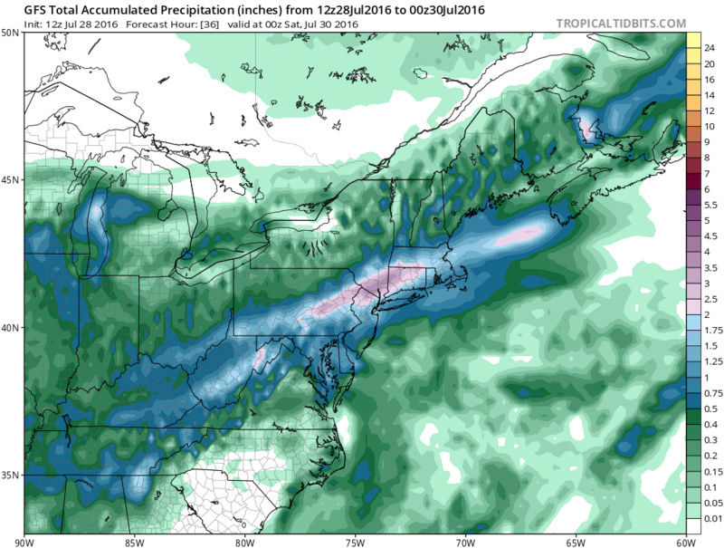
![]() by jmanley32 Thu Jul 28, 2016 7:17 pm
by jmanley32 Thu Jul 28, 2016 7:17 pm
I see, seems area is going to fill in latest GFS has 2-4 inch swatch right through NYC metro.
Last edited by jmanley32 on Thu Jul 28, 2016 7:24 pm; edited 1 time in total
jmanley32- Senior Enthusiast
- Posts : 20512
Reputation : 108
Join date : 2013-12-12
Age : 42
Location : Yonkers, NY
Re: 7/29-7/31 Possible Heavy Rain Event Disco/Obs.
![]() by docstox12 Thu Jul 28, 2016 7:24 pm
by docstox12 Thu Jul 28, 2016 7:24 pm

docstox12- Wx Statistician Guru

- Posts : 8501
Reputation : 222
Join date : 2013-01-07
Age : 73
Location : Monroe NY
Page 1 of 3 • 1, 2, 3 ![]()
|
|
|