
 Search
Long Range Thread 12.0
Page 7 of 40 •  1 ... 6, 7, 8 ... 23 ... 40
 ![]()
Re: Long Range Thread 12.0
![]() by amugs Fri Sep 30, 2016 10:18 am
by amugs Fri Sep 30, 2016 10:18 am

1 week ago

amugs- Advanced Forecaster - Mod

- Posts : 15091
Join date : 2013-01-07
Re: Long Range Thread 12.0
![]() by sroc4 Fri Sep 30, 2016 10:28 am
by sroc4 Fri Sep 30, 2016 10:28 am
amugs wrote:Look at the Snow Growth in Siberia - WOW!!
1 week ago
Departure from normal:

sroc4- Admin

- Posts : 8331
Join date : 2013-01-07
Re: Long Range Thread 12.0
![]() by sroc4 Mon Oct 03, 2016 7:50 am
by sroc4 Mon Oct 03, 2016 7:50 am


Also on a positive note Siberian snow cover continues to grow above normal.

_________________
"In weather and in life, there's no winning and losing; there's only winning and learning."
WINTER 2012/2013 TOTALS 43.65"WINTER 2017/2018 TOTALS 62.85" WINTER 2022/2023 TOTALS 4.9"
WINTER 2013/2014 TOTALS 64.85"WINTER 2018/2019 TOTALS 14.25" WINTER 2023/2024 TOTALS 13.1"
WINTER 2014/2015 TOTALS 71.20"WINTER 2019/2020 TOTALS 6.35"
WINTER 2015/2016 TOTALS 35.00"WINTER 2020/2021 TOTALS 37.75"
WINTER 2016/2017 TOTALS 42.25"WINTER 2021/2022 TOTALS 31.65"

sroc4- Admin
- Posts : 8331
Reputation : 301
Join date : 2013-01-07
Location : Wading River, LI
Re: Long Range Thread 12.0
![]() by amugs Wed Oct 05, 2016 7:10 pm
by amugs Wed Oct 05, 2016 7:10 pm
_________________
Mugs
AKA:King: Snow Weenie
Self Proclaimed
WINTER 2014-15 : 55.12" +.02 for 6 coatings (avg. 35")
WINTER 2015-16 Total - 29.8" (Avg 35")
WINTER 2016-17 : 39.5" so far

amugs- Advanced Forecaster - Mod
- Posts : 15091
Reputation : 213
Join date : 2013-01-07
Age : 54
Location : Hillsdale,NJ
Re: Long Range Thread 12.0
![]() by amugs Wed Oct 05, 2016 7:12 pm
by amugs Wed Oct 05, 2016 7:12 pm
10-5 Today
Last week

_________________
Mugs
AKA:King: Snow Weenie
Self Proclaimed
WINTER 2014-15 : 55.12" +.02 for 6 coatings (avg. 35")
WINTER 2015-16 Total - 29.8" (Avg 35")
WINTER 2016-17 : 39.5" so far
amugs- Advanced Forecaster - Mod
- Posts : 15091
Reputation : 213
Join date : 2013-01-07
Age : 54
Location : Hillsdale,NJ
Re: Long Range Thread 12.0
![]() by frank 638 Wed Oct 05, 2016 9:19 pm
by frank 638 Wed Oct 05, 2016 9:19 pm
frank 638- Senior Enthusiast

- Posts : 2823
Reputation : 37
Join date : 2016-01-01
Age : 40
Location : bronx ny
Re: Long Range Thread 12.0
![]() by Frank_Wx Wed Oct 05, 2016 9:29 pm
by Frank_Wx Wed Oct 05, 2016 9:29 pm
sroc4 wrote:I figured Id post this just to shift the gears of the brain, if not briefly. It certainly appears that the persistent easterlies throughout the month of Sept have done their dirty work and shifted all Nino regions back towards weak La Nina status, with the exception of Nino 1+2 which is neutral. IO conts to cool as well. One thing I may be concerned with is the warmest anomalies seem to be setting up N of Austrailia and Indonesia which coincide with MJO regions 4-6. If the strongest forcing/convection sets up in this region, and gets stuck there during the winter months we could end up with Warm anomalies over the east. This is all simply a big if. Many other aspects to consider, but just a thought.
Also on a positive note Siberian snow cover continues to grow above normal.
Good post. I'll begin gathering data for winter outlook in another 2 weeks. Your concern is NOTED
_________________
_______________________________________________________________________________________________________
CLICK HERE to view NJ Strong Snowstorm Classifications

Frank_Wx- Godzilla Seeker
- Posts : 21305
Reputation : 328
Join date : 2013-01-05
Age : 31
Location : Jersey City, NJ -

Re: Long Range Thread 12.0
![]() by Isotherm Thu Oct 06, 2016 9:07 am
by Isotherm Thu Oct 06, 2016 9:07 am
Isotherm- Advanced Forecaster

- Posts : 231
Reputation : 4
Join date : 2014-09-01
Age : 33
Location : Monmouth County, NJ -
Re: Long Range Thread 12.0
![]() by amugs Thu Oct 06, 2016 9:47 am
by amugs Thu Oct 06, 2016 9:47 am
Isotherm wrote:Keep in mind, above normal snow cover in the NHEM isn't necessarily a good indicator right now, at least insofar as the SAI. Weeks 42-44 (mid/late October) are most critical with respect to the rapid increase of snowfall. Since rate of change seems to be most strongly correlated with the ensuing NAM, initiating the process with high snowfall decreases the probability that the rate of increase will be impressive. Thus, as far as the SAI is concerned, one would rather have below normal snow cover now transitioning toward much above. However, an overarching disclaimer is that the SAI is merely one tool. I couple winters ago (2013-14 I believe), we had an unimpressive SAI but robust SCE, and the ensuing AO was slightly negative. So, it's not the be all end all of course.
Interesting - Bill Goodman from NWS said in a NJWO group presentation that NWS and long forecasters use the SAI and what they construe as the snow intensification growth (I think this is what you are saying) as a strong, much heavily weighted prognosticator for the AO values come winter in the means. He said the from the 1st week of October (now)to the 1st week of November (30 day indicator)is what their main concern is well information to see how the growth has developed. It is a small envelope in the massive fluid dynamic of our atmosphere but interesting to note.
_________________
Mugs
AKA:King: Snow Weenie
Self Proclaimed
WINTER 2014-15 : 55.12" +.02 for 6 coatings (avg. 35")
WINTER 2015-16 Total - 29.8" (Avg 35")
WINTER 2016-17 : 39.5" so far
amugs- Advanced Forecaster - Mod
- Posts : 15091
Reputation : 213
Join date : 2013-01-07
Age : 54
Location : Hillsdale,NJ
Re: Long Range Thread 12.0
![]() by algae888 Thu Oct 06, 2016 11:33 am
by algae888 Thu Oct 06, 2016 11:33 am

algae888- Advanced Forecaster
- Posts : 5311
Reputation : 46
Join date : 2013-02-05
Age : 61
Location : mt. vernon, new york
Long Range Thread 12.0
![]() by Frank_Wx Sat Oct 08, 2016 8:44 am
by Frank_Wx Sat Oct 08, 2016 8:44 am

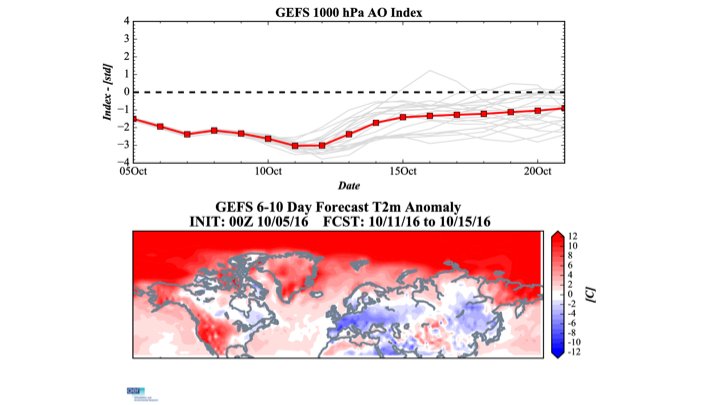
We're entering the time of year where the Polar Vortex will begin to establish itself over the Arctic. You can see it over the Arctic Circle in this image. It's important to note the PV is weaker this year than it was this time last year. I'll discuss the potential upside that may have on our winter in the outlook.
This image is 500mb height anonalies in the next 7 to 10 days. Check out the deep trough in the northeast Pacific. We have a roaring Pacific northern jet extending from Asia into the PAC NW of the U.S. These two elements in our atmosphere (trough and jet) should keep us under normal to slightly above normal temps for the rest of October.
There is some east based blocking, shown by the positive heights east of Greenland, that will keep a weak trough over northern parts of our area but mainly New England. We'll likely be stuck in the middle between the northern trough and southwestern ridge for the remainder of the month.
Happy tracking!
_________________
_______________________________________________________________________________________________________
CLICK HERE to view NJ Strong Snowstorm Classifications
Frank_Wx- Godzilla Seeker
- Posts : 21305
Reputation : 328
Join date : 2013-01-05
Age : 31
Location : Jersey City, NJ -
Re: Long Range Thread 12.0
![]() by amugs Sat Oct 08, 2016 8:32 pm
by amugs Sat Oct 08, 2016 8:32 pm
_________________
Mugs
AKA:King: Snow Weenie
Self Proclaimed
WINTER 2014-15 : 55.12" +.02 for 6 coatings (avg. 35")
WINTER 2015-16 Total - 29.8" (Avg 35")
WINTER 2016-17 : 39.5" so far
amugs- Advanced Forecaster - Mod
- Posts : 15091
Reputation : 213
Join date : 2013-01-07
Age : 54
Location : Hillsdale,NJ
Re: Long Range Thread 12.0
![]() by chief7 Sat Oct 08, 2016 9:06 pm
by chief7 Sat Oct 08, 2016 9:06 pm
chief7- Posts : 132
Reputation : 0
Join date : 2013-11-10
Location : Langhorne pa
Re: Long Range Thread 12.0
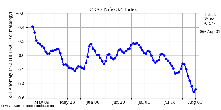
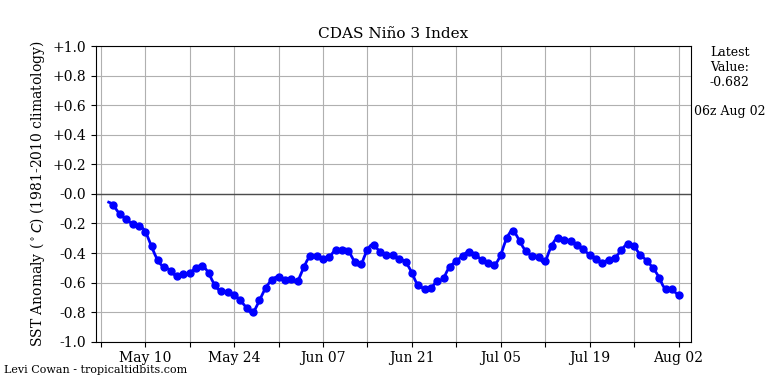
![]() by amugs Mon Oct 10, 2016 9:04 am
by amugs Mon Oct 10, 2016 9:04 am
http://www.cpc.ncep.noaa.gov/data/indices/wksst8110.for
Latest values:
Nino 1.2: +0.1 (-0.5)
Nino 3: -0.6 (-0.4)
Nino 3.4: -0.9 (-0.1)
Nino 4: -0.6 (-0.1)
_________________
Mugs
AKA:King: Snow Weenie
Self Proclaimed
WINTER 2014-15 : 55.12" +.02 for 6 coatings (avg. 35")
WINTER 2015-16 Total - 29.8" (Avg 35")
WINTER 2016-17 : 39.5" so far
amugs- Advanced Forecaster - Mod
- Posts : 15091
Reputation : 213
Join date : 2013-01-07
Age : 54
Location : Hillsdale,NJ
Re: Long Range Thread 12.0
![]() by Snow88 Mon Oct 10, 2016 9:19 am
by Snow88 Mon Oct 10, 2016 9:19 am

Snow88- Senior Enthusiast
- Posts : 2193
Reputation : 4
Join date : 2013-01-09
Age : 35
Location : Brooklyn, NY
Re: Long Range Thread 12.0
![]() by algae888 Wed Oct 12, 2016 9:54 am
by algae888 Wed Oct 12, 2016 9:54 am
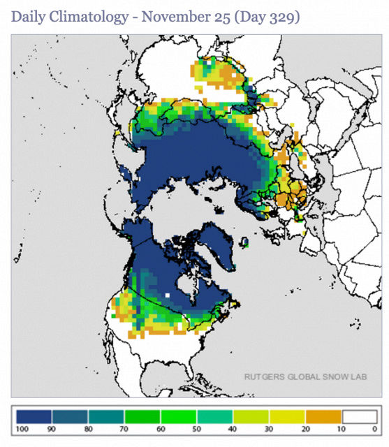
"Both low sea ice and the negative AO are favorable for the rapid advance of Siberian snow cover. Eurasian snow cover is above normal and this trend should continue through at least mid-month. High Eurasian snow cover and low Arctic sea ice in the Barents-Kara seas favor first, a strengthening Siberian high and then a weakened polar vortex in winter.
The polar vortex both in the stratosphere and the troposphere are unusually weak so far this fall, if this trend continues severe winter weather is likely for widespread portions of northern Eurasia, including Europe and East Asia, and the eastern United States (US)."
Last edited by algae888 on Wed Oct 12, 2016 10:01 am; edited 1 time in total
algae888- Advanced Forecaster
- Posts : 5311
Reputation : 46
Join date : 2013-02-05
Age : 61
Location : mt. vernon, new york
Re: Long Range Thread 12.0
![]() by algae888 Wed Oct 12, 2016 10:00 am
by algae888 Wed Oct 12, 2016 10:00 am
"mpacts
In previous blogs I noted the unusually negative AO in the stratosphere and that the strong positive polar cap height anomalies look to be descending down into the troposphere. The weak stratospheric polar vortex has now been followed by an unusually weak tropospheric polar vortex and a deeply negative tropospheric AO. This is not the time of year when tropospheric-stratospheric coupling is considered active but the most recent polar cap height anomaly (PCH) plot is certainly suggestive of a downward propagation of warm/positive PCH from the stratosphere to the troposphere. Regardless, the tropospheric AO is strongly negative, which favors widespread cold temperatures across the NH mid-latitudes, especially northern Eurasia and a rapid advance in snow cover especially Siberia and to a lesser extent Canada. October Eurasian snow cover extent is a key predictor in our winter forecast and if our expectations are correct that Eurasian snow cover will be above normal for the month of October, this will bias our model colder for the winter forecast.
As I have discussed in previous blogs, the Arctic sea ice is well below normal and possibly most importantly for longer term weather sea ice is below normal in the Barents-Kara seas. This will also bias the winter forecast colder. Also with the likelihood that the AO will be strongly negative right through the middle of October, October 2016 will probably rival other recent Octobers for the most negative October AO observed, which include October 2002 and 2009. And though there is not a strong relationship between the October AO and the winter AO, the winter AO in 2002/03 and 2009/10 were both negative and cold temperatures were widespread both across northern Eurasia and the Eastern US. However the AO was much more negative in the latter winter and the evolution of the polar vortex was quite different. It is still very early and the outcome of this winter still very much in doubt but in my opinion, the longer that the tropospheric and/or stratospheric polar vortex remain weak and the AO negative, favors a colder winter solution."
algae888- Advanced Forecaster
- Posts : 5311
Reputation : 46
Join date : 2013-02-05
Age : 61
Location : mt. vernon, new york
Re: Long Range Thread 12.0
![]() by amugs Wed Oct 12, 2016 3:26 pm
by amugs Wed Oct 12, 2016 3:26 pm


Up close - look at these beauties


_________________
Mugs
AKA:King: Snow Weenie
Self Proclaimed
WINTER 2014-15 : 55.12" +.02 for 6 coatings (avg. 35")
WINTER 2015-16 Total - 29.8" (Avg 35")
WINTER 2016-17 : 39.5" so far
amugs- Advanced Forecaster - Mod
- Posts : 15091
Reputation : 213
Join date : 2013-01-07
Age : 54
Location : Hillsdale,NJ
Re: Long Range Thread 12.0
![]() by amugs Wed Oct 12, 2016 3:33 pm
by amugs Wed Oct 12, 2016 3:33 pm
http://onlinelibrary.wiley.com/doi/10.1002/joc.4616/abstract
Also lets not forget the NAO July prognosticator that is to give us a clue as to the Winter regime for the NAO - If Negative in July then science is theorizing that it will be Negative in January but also in the means for the winter.
2016 0.12 1.58 0.73 0.38 -0.77 -0.43 -1.76 -1.65 0.61
La Nina
28SEP2016 21.2 0.6 24.7-0.2 25.9-0.8 28.1-0.5
05OCT2016 20.8 0.1 24.3-0.6 25.8-0.9 28.1-0.6
_________________
Mugs
AKA:King: Snow Weenie
Self Proclaimed
WINTER 2014-15 : 55.12" +.02 for 6 coatings (avg. 35")
WINTER 2015-16 Total - 29.8" (Avg 35")
WINTER 2016-17 : 39.5" so far
amugs- Advanced Forecaster - Mod
- Posts : 15091
Reputation : 213
Join date : 2013-01-07
Age : 54
Location : Hillsdale,NJ
Re: Long Range Thread 12.0
![]() by Frank_Wx Thu Oct 13, 2016 8:23 am
by Frank_Wx Thu Oct 13, 2016 8:23 am
_________________
_______________________________________________________________________________________________________
CLICK HERE to view NJ Strong Snowstorm Classifications
Frank_Wx- Godzilla Seeker
- Posts : 21305
Reputation : 328
Join date : 2013-01-05
Age : 31
Location : Jersey City, NJ -
Re: Long Range Thread 12.0
![]() by sroc4 Thu Oct 13, 2016 10:27 am
by sroc4 Thu Oct 13, 2016 10:27 am
Frank_Wx wrote:Long range is beginning to have a winter feel to it. Cold air gradually working its way into the CONUS.
Images like this excite me. I hope we see these sorts of images all winter:

_________________
"In weather and in life, there's no winning and losing; there's only winning and learning."
WINTER 2012/2013 TOTALS 43.65"WINTER 2017/2018 TOTALS 62.85" WINTER 2022/2023 TOTALS 4.9"
WINTER 2013/2014 TOTALS 64.85"WINTER 2018/2019 TOTALS 14.25" WINTER 2023/2024 TOTALS 13.1"
WINTER 2014/2015 TOTALS 71.20"WINTER 2019/2020 TOTALS 6.35"
WINTER 2015/2016 TOTALS 35.00"WINTER 2020/2021 TOTALS 37.75"
WINTER 2016/2017 TOTALS 42.25"WINTER 2021/2022 TOTALS 31.65"
sroc4- Admin
- Posts : 8331
Reputation : 301
Join date : 2013-01-07
Location : Wading River, LI
Re: Long Range Thread 12.0
![]() by amugs Thu Oct 13, 2016 1:22 pm
by amugs Thu Oct 13, 2016 1:22 pm
amugs wrote:Interesting article on Autumnal AO and regards to correlation with Winter AO in teh emans regime
http://onlinelibrary.wiley.com/doi/10.1002/joc.4616/abstract
Also lets not forget the NAO July prognosticator that is to give us a clue as to the Winter regime for the NAO - If Negative in July then science is theorizing that it will be Negative in January but also in the means for the winter.
2016 0.12 1.58 0.73 0.38 -0.77 -0.43 -1.76 -1.65 0.61
La Nina
28SEP2016 21.2 0.6 24.7-0.2 25.9-0.8 28.1-0.5
05OCT2016 20.8 0.1 24.3-0.6 25.8-0.9 28.1-0.6
LA NINA WATCH IS BACK!!! NOAA SAYS SO
https://www.climate.gov/news-features/understanding-climate/el-ni%C3%B1o-and-la-ni%C3%B1a-alert-system
_________________
Mugs
AKA:King: Snow Weenie
Self Proclaimed
WINTER 2014-15 : 55.12" +.02 for 6 coatings (avg. 35")
WINTER 2015-16 Total - 29.8" (Avg 35")
WINTER 2016-17 : 39.5" so far
amugs- Advanced Forecaster - Mod
- Posts : 15091
Reputation : 213
Join date : 2013-01-07
Age : 54
Location : Hillsdale,NJ
Re: Long Range Thread 12.0
![]() by sroc4 Thu Oct 13, 2016 1:32 pm
by sroc4 Thu Oct 13, 2016 1:32 pm
amugs wrote:amugs wrote:Interesting article on Autumnal AO and regards to correlation with Winter AO in teh emans regime
http://onlinelibrary.wiley.com/doi/10.1002/joc.4616/abstract
Also lets not forget the NAO July prognosticator that is to give us a clue as to the Winter regime for the NAO - If Negative in July then science is theorizing that it will be Negative in January but also in the means for the winter.
2016 0.12 1.58 0.73 0.38 -0.77 -0.43 -1.76 -1.65 0.61
La Nina
28SEP2016 21.2 0.6 24.7-0.2 25.9-0.8 28.1-0.5
05OCT2016 20.8 0.1 24.3-0.6 25.8-0.9 28.1-0.6
LA NINA WATCH IS BACK!!! NOAA SAYS SO
https://www.climate.gov/news-features/understanding-climate/el-ni%C3%B1o-and-la-ni%C3%B1a-alert-system
Hmmm I believe a certain someone about a month ago said to not buy into the Nina cancel just yet.
_________________
"In weather and in life, there's no winning and losing; there's only winning and learning."
WINTER 2012/2013 TOTALS 43.65"WINTER 2017/2018 TOTALS 62.85" WINTER 2022/2023 TOTALS 4.9"
WINTER 2013/2014 TOTALS 64.85"WINTER 2018/2019 TOTALS 14.25" WINTER 2023/2024 TOTALS 13.1"
WINTER 2014/2015 TOTALS 71.20"WINTER 2019/2020 TOTALS 6.35"
WINTER 2015/2016 TOTALS 35.00"WINTER 2020/2021 TOTALS 37.75"
WINTER 2016/2017 TOTALS 42.25"WINTER 2021/2022 TOTALS 31.65"
sroc4- Admin
- Posts : 8331
Reputation : 301
Join date : 2013-01-07
Location : Wading River, LI
Re: Long Range Thread 12.0
![]() by amugs Thu Oct 13, 2016 4:40 pm
by amugs Thu Oct 13, 2016 4:40 pm
sroc4 wrote:amugs wrote:amugs wrote:Interesting article on Autumnal AO and regards to correlation with Winter AO in teh emans regime
http://onlinelibrary.wiley.com/doi/10.1002/joc.4616/abstract
Also lets not forget the NAO July prognosticator that is to give us a clue as to the Winter regime for the NAO - If Negative in July then science is theorizing that it will be Negative in January but also in the means for the winter.
2016 0.12 1.58 0.73 0.38 -0.77 -0.43 -1.76 -1.65 0.61
La Nina
28SEP2016 21.2 0.6 24.7-0.2 25.9-0.8 28.1-0.5
05OCT2016 20.8 0.1 24.3-0.6 25.8-0.9 28.1-0.6
LA NINA WATCH IS BACK!!! NOAA SAYS SO
https://www.climate.gov/news-features/understanding-climate/el-ni%C3%B1o-and-la-ni%C3%B1a-alert-system
Hmmm I believe a certain someone about a month ago said to not buy into the Nina cancel just yet.
Mushy?? The person you referenced to Ryan in his research in the Banter thread?
This is what I am talkin' about peeps - bring the goods and build the snow pack to our North and we will take these vorts that drop down and keep them cold - wont moderate much if any!

_________________
Mugs
AKA:King: Snow Weenie
Self Proclaimed
WINTER 2014-15 : 55.12" +.02 for 6 coatings (avg. 35")
WINTER 2015-16 Total - 29.8" (Avg 35")
WINTER 2016-17 : 39.5" so far
amugs- Advanced Forecaster - Mod
- Posts : 15091
Reputation : 213
Join date : 2013-01-07
Age : 54
Location : Hillsdale,NJ
Re: Long Range Thread 12.0
![]() by jmanley32 Thu Oct 13, 2016 5:19 pm
by jmanley32 Thu Oct 13, 2016 5:19 pm
25th!

jmanley32- Senior Enthusiast
- Posts : 20512
Reputation : 108
Join date : 2013-12-12
Age : 42
Location : Yonkers, NY
Re: Long Range Thread 12.0
![]() by sroc4 Thu Oct 13, 2016 5:35 pm
by sroc4 Thu Oct 13, 2016 5:35 pm
amugs wrote:sroc4 wrote:amugs wrote:amugs wrote:Interesting article on Autumnal AO and regards to correlation with Winter AO in teh emans regime
http://onlinelibrary.wiley.com/doi/10.1002/joc.4616/abstract
Also lets not forget the NAO July prognosticator that is to give us a clue as to the Winter regime for the NAO - If Negative in July then science is theorizing that it will be Negative in January but also in the means for the winter.
2016 0.12 1.58 0.73 0.38 -0.77 -0.43 -1.76 -1.65 0.61
La Nina
28SEP2016 21.2 0.6 24.7-0.2 25.9-0.8 28.1-0.5
05OCT2016 20.8 0.1 24.3-0.6 25.8-0.9 28.1-0.6
LA NINA WATCH IS BACK!!! NOAA SAYS SO
https://www.climate.gov/news-features/understanding-climate/el-ni%C3%B1o-and-la-ni%C3%B1a-alert-system
Hmmm I believe a certain someone about a month ago said to not buy into the Nina cancel just yet.
Mushy?? The person you referenced to Ryan in his research in the Banter thread?
This is what I am talkin' about peeps - bring the goods and build the snow pack to our North and we will take these vorts that drop down and keep them cold - wont moderate much if any!
LOL Sorry about that MUGSY. My phone Auto corrected the shy-za out me. I guess we both knew the Nina cancel was premature.
_________________
"In weather and in life, there's no winning and losing; there's only winning and learning."
WINTER 2012/2013 TOTALS 43.65"WINTER 2017/2018 TOTALS 62.85" WINTER 2022/2023 TOTALS 4.9"
WINTER 2013/2014 TOTALS 64.85"WINTER 2018/2019 TOTALS 14.25" WINTER 2023/2024 TOTALS 13.1"
WINTER 2014/2015 TOTALS 71.20"WINTER 2019/2020 TOTALS 6.35"
WINTER 2015/2016 TOTALS 35.00"WINTER 2020/2021 TOTALS 37.75"
WINTER 2016/2017 TOTALS 42.25"WINTER 2021/2022 TOTALS 31.65"
sroc4- Admin
- Posts : 8331
Reputation : 301
Join date : 2013-01-07
Location : Wading River, LI
Re: Long Range Thread 12.0
![]() by amugs Thu Oct 13, 2016 7:06 pm
by amugs Thu Oct 13, 2016 7:06 pm
_________________
Mugs
AKA:King: Snow Weenie
Self Proclaimed
WINTER 2014-15 : 55.12" +.02 for 6 coatings (avg. 35")
WINTER 2015-16 Total - 29.8" (Avg 35")
WINTER 2016-17 : 39.5" so far
amugs- Advanced Forecaster - Mod
- Posts : 15091
Reputation : 213
Join date : 2013-01-07
Age : 54
Location : Hillsdale,NJ
Page 7 of 40 • 1 ... 6, 7, 8 ... 23 ... 40 ![]()
|
|
|