
 Search
Sun-Mon 12/11-12/12 Discussions and Observations
Page 2 of 7 •  1, 2, 3, 4, 5, 6, 7
 ![]()
Re: Sun-Mon 12/11-12/12 Discussions and Observations
![]() by Dunnzoo Thu Dec 08, 2016 8:01 pm
by Dunnzoo Thu Dec 08, 2016 8:01 pm
Dunnzoo- Senior Enthusiast - Mod

- Posts : 4882
Join date : 2013-01-11
Re: Sun-Mon 12/11-12/12 Discussions and Observations
![]() by skinsfan1177 Thu Dec 08, 2016 8:11 pm
by skinsfan1177 Thu Dec 08, 2016 8:11 pm
skinsfan1177- Senior Enthusiast

- Posts : 4485
Join date : 2013-01-07
Re: Sun-Mon 12/11-12/12 Discussions and Observations
![]() by amugs Thu Dec 08, 2016 8:11 pm
by amugs Thu Dec 08, 2016 8:11 pm
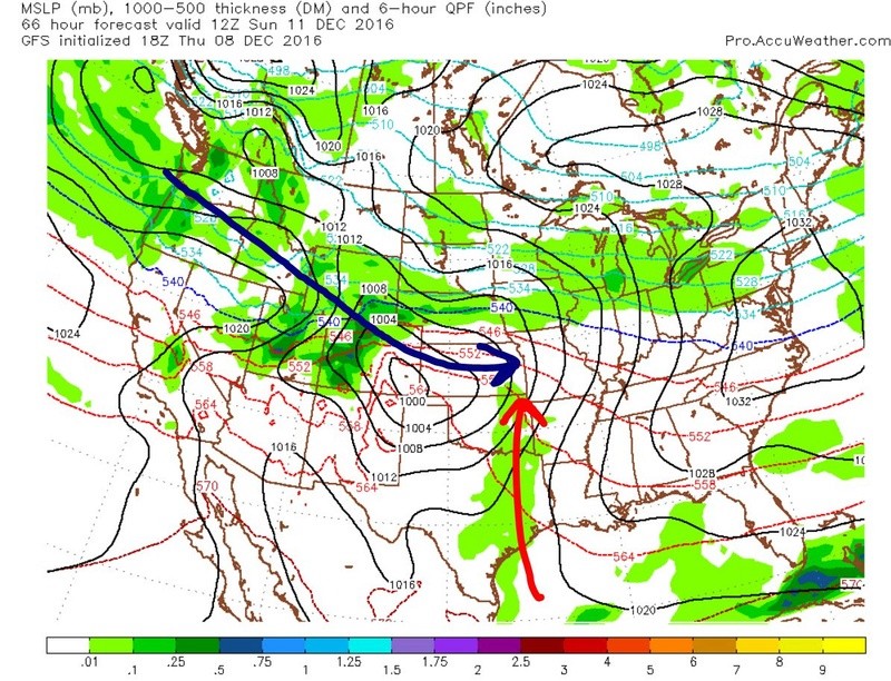
Gfs has an amped system, not seeing how it gets so amped imo.
It will be tapping some gulf moisture though
_________________
Mugs
AKA:King: Snow Weenie
Self Proclaimed
WINTER 2014-15 : 55.12" +.02 for 6 coatings (avg. 35")
WINTER 2015-16 Total - 29.8" (Avg 35")
WINTER 2016-17 : 39.5" so far

amugs- Advanced Forecaster - Mod
- Posts : 15091
Reputation : 213
Join date : 2013-01-07
Age : 54
Location : Hillsdale,NJ
Re: Sun-Mon 12/11-12/12 Discussions and Observations
![]() by rb924119 Thu Dec 08, 2016 8:24 pm
by rb924119 Thu Dec 08, 2016 8:24 pm
amugs wrote:We tap some gulf moisture here and then
Gfs has an amped system, not seeing how it gets so amped imo.
It will be tapping some gulf moisture though
I don't know if you read my writeup from earlier, but I think it's due to vortex tube stretching, as this type of setup looks prime for that to occur in my opinion. I'm actually siding with the GFS on this one, at least for now.
rb924119- Meteorologist

- Posts : 6888
Reputation : 194
Join date : 2013-02-06
Age : 32
Location : Greentown, Pa
Re: Sun-Mon 12/11-12/12 Discussions and Observations
![]() by Frank_Wx Thu Dec 08, 2016 9:30 pm
by Frank_Wx Thu Dec 08, 2016 9:30 pm
https://www.njstrongweatherforum.com/t759-monday-12-12-storm-update-1#95942
_________________
_______________________________________________________________________________________________________
CLICK HERE to view NJ Strong Snowstorm Classifications

Frank_Wx- Godzilla Seeker

- Posts : 21305
Reputation : 328
Join date : 2013-01-05
Age : 31
Location : Jersey City, NJ -

Re: Sun-Mon 12/11-12/12 Discussions and Observations
![]() by Frank_Wx Thu Dec 08, 2016 10:26 pm
by Frank_Wx Thu Dec 08, 2016 10:26 pm
_________________
_______________________________________________________________________________________________________
CLICK HERE to view NJ Strong Snowstorm Classifications
Frank_Wx- Godzilla Seeker
- Posts : 21305
Reputation : 328
Join date : 2013-01-05
Age : 31
Location : Jersey City, NJ -
Re: Sun-Mon 12/11-12/12 Discussions and Observations
![]() by amugs Thu Dec 08, 2016 10:36 pm
by amugs Thu Dec 08, 2016 10:36 pm
_________________
Mugs
AKA:King: Snow Weenie
Self Proclaimed
WINTER 2014-15 : 55.12" +.02 for 6 coatings (avg. 35")
WINTER 2015-16 Total - 29.8" (Avg 35")
WINTER 2016-17 : 39.5" so far
amugs- Advanced Forecaster - Mod
- Posts : 15091
Reputation : 213
Join date : 2013-01-07
Age : 54
Location : Hillsdale,NJ
Re: Sun-Mon 12/11-12/12 Discussions and Observations
![]() by Frank_Wx Thu Dec 08, 2016 10:40 pm
by Frank_Wx Thu Dec 08, 2016 10:40 pm
_________________
_______________________________________________________________________________________________________
CLICK HERE to view NJ Strong Snowstorm Classifications
Frank_Wx- Godzilla Seeker
- Posts : 21305
Reputation : 328
Join date : 2013-01-05
Age : 31
Location : Jersey City, NJ -
Re: Sun-Mon 12/11-12/12 Discussions and Observations
![]() by Frank_Wx Thu Dec 08, 2016 10:46 pm
by Frank_Wx Thu Dec 08, 2016 10:46 pm
_________________
_______________________________________________________________________________________________________
CLICK HERE to view NJ Strong Snowstorm Classifications
Frank_Wx- Godzilla Seeker
- Posts : 21305
Reputation : 328
Join date : 2013-01-05
Age : 31
Location : Jersey City, NJ -
Re: Sun-Mon 12/11-12/12 Discussions and Observations
![]() by Frank_Wx Thu Dec 08, 2016 10:51 pm
by Frank_Wx Thu Dec 08, 2016 10:51 pm
_________________
_______________________________________________________________________________________________________
CLICK HERE to view NJ Strong Snowstorm Classifications
Frank_Wx- Godzilla Seeker
- Posts : 21305
Reputation : 328
Join date : 2013-01-05
Age : 31
Location : Jersey City, NJ -
Re: Sun-Mon 12/11-12/12 Discussions and Observations
![]() by Frank_Wx Thu Dec 08, 2016 10:53 pm
by Frank_Wx Thu Dec 08, 2016 10:53 pm
_________________
_______________________________________________________________________________________________________
CLICK HERE to view NJ Strong Snowstorm Classifications
Frank_Wx- Godzilla Seeker
- Posts : 21305
Reputation : 328
Join date : 2013-01-05
Age : 31
Location : Jersey City, NJ -
Re: Sun-Mon 12/11-12/12 Discussions and Observations
![]() by Frank_Wx Thu Dec 08, 2016 11:20 pm
by Frank_Wx Thu Dec 08, 2016 11:20 pm


_________________
_______________________________________________________________________________________________________
CLICK HERE to view NJ Strong Snowstorm Classifications
Frank_Wx- Godzilla Seeker
- Posts : 21305
Reputation : 328
Join date : 2013-01-05
Age : 31
Location : Jersey City, NJ -
Re: Sun-Mon 12/11-12/12 Discussions and Observations
![]() by skinsfan1177 Fri Dec 09, 2016 6:38 am
by skinsfan1177 Fri Dec 09, 2016 6:38 am

skinsfan1177- Senior Enthusiast
- Posts : 4485
Reputation : 35
Join date : 2013-01-07
Age : 46
Location : Point Pleasant Boro
Re: Sun-Mon 12/11-12/12 Discussions and Observations
![]() by Frank_Wx Fri Dec 09, 2016 7:12 am
by Frank_Wx Fri Dec 09, 2016 7:12 am
If that feature is real - and it looks like it but let's see what today brings - then NYC will see very minor snow from this and mainly rain.
_________________
_______________________________________________________________________________________________________
CLICK HERE to view NJ Strong Snowstorm Classifications
Frank_Wx- Godzilla Seeker
- Posts : 21305
Reputation : 328
Join date : 2013-01-05
Age : 31
Location : Jersey City, NJ -
Re: Sun-Mon 12/11-12/12 Discussions and Observations
![]() by Frank_Wx Fri Dec 09, 2016 7:18 am
by Frank_Wx Fri Dec 09, 2016 7:18 am
12z EURO valid 7am Sunday

00z EURO valid 7am Sunday

_________________
_______________________________________________________________________________________________________
CLICK HERE to view NJ Strong Snowstorm Classifications
Frank_Wx- Godzilla Seeker
- Posts : 21305
Reputation : 328
Join date : 2013-01-05
Age : 31
Location : Jersey City, NJ -
Re: Sun-Mon 12/11-12/12 Discussions and Observations
![]() by sroc4 Fri Dec 09, 2016 7:37 am
by sroc4 Fri Dec 09, 2016 7:37 am


Now of course as been stated the stronger the system when it reaches the Ohio valley the higher the heights get out ahead of it and the quicker the warming of the low levels. Ironically the Euro had the strongest energy on the 7th runs with GFS the weakest, and now the GFS is strongest. That said even with a weaker system with the energy further north as depicted by the latest set of runs this in effect leads to a boundary layer that will be further north to begin with. So even the weaker soln its going to take less of a height rise to bring the warmer 925mb and 850mb into the southern portions of the region making it even tougher now for the coastal plain to see any significant accumulations (ie: > or = to an inch or more). I'm not saying it still cant and/or wont happen but for the coastal plain trends are not in our favor. The energy that will bring this event is coming onshore today into the overnight tonight so thre is still time for trends for better or worse.
_________________
"In weather and in life, there's no winning and losing; there's only winning and learning."
WINTER 2012/2013 TOTALS 43.65"WINTER 2017/2018 TOTALS 62.85" WINTER 2022/2023 TOTALS 4.9"
WINTER 2013/2014 TOTALS 64.85"WINTER 2018/2019 TOTALS 14.25" WINTER 2023/2024 TOTALS 13.1"
WINTER 2014/2015 TOTALS 71.20"WINTER 2019/2020 TOTALS 6.35"
WINTER 2015/2016 TOTALS 35.00"WINTER 2020/2021 TOTALS 37.75"
WINTER 2016/2017 TOTALS 42.25"WINTER 2021/2022 TOTALS 31.65"

sroc4- Admin
- Posts : 8331
Reputation : 301
Join date : 2013-01-07
Location : Wading River, LI
Re: Sun-Mon 12/11-12/12 Discussions and Observations
![]() by sroc4 Fri Dec 09, 2016 7:50 am
by sroc4 Fri Dec 09, 2016 7:50 am
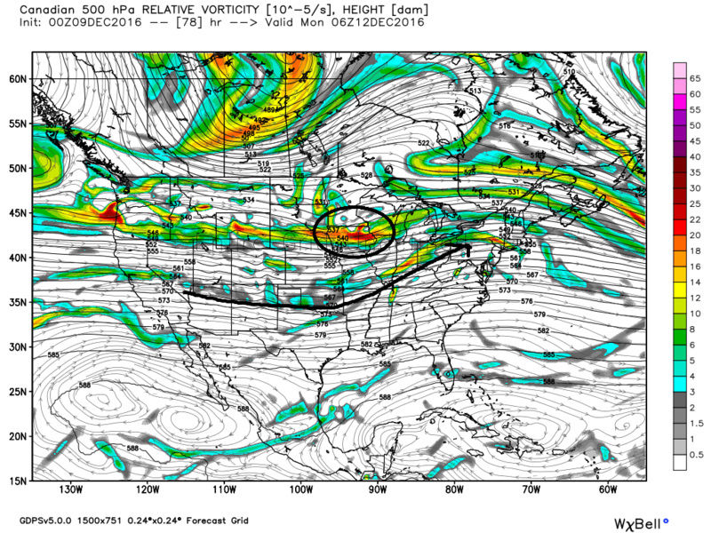
Frank_Wx wrote:In the play by play last night and in my writeup, I expressed concern a piece of vorticity could break off the PV and phase with the leading PAC energy which would amplify the trough and surface low. The EURO last night took a step toward the GFS by showing that small but important 500mb vort breaking off the PV.
If that feature is real - and it looks like it but let's see what today brings - then NYC will see very minor snow from this and mainly rain.
Frank not that it makes a huge difference in the long run, but if you follow frame by frame I'm not sure its actually a piece from the PV that interacts but rather two separate pieces from the same original energy that get created as the main energy moves onshore and gets torn up a bit as it passes over the rockies. As both pieces re-emerge on the other side and head east they then interact once again.


I guess this small semantic may be important in that models may not have a handle on how weak or strong the two pieces actually are because the interactions with the Rockies could be highly variable. Just a thought.
_________________
"In weather and in life, there's no winning and losing; there's only winning and learning."
WINTER 2012/2013 TOTALS 43.65"WINTER 2017/2018 TOTALS 62.85" WINTER 2022/2023 TOTALS 4.9"
WINTER 2013/2014 TOTALS 64.85"WINTER 2018/2019 TOTALS 14.25" WINTER 2023/2024 TOTALS 13.1"
WINTER 2014/2015 TOTALS 71.20"WINTER 2019/2020 TOTALS 6.35"
WINTER 2015/2016 TOTALS 35.00"WINTER 2020/2021 TOTALS 37.75"
WINTER 2016/2017 TOTALS 42.25"WINTER 2021/2022 TOTALS 31.65"
sroc4- Admin
- Posts : 8331
Reputation : 301
Join date : 2013-01-07
Location : Wading River, LI
Re: Sun-Mon 12/11-12/12 Discussions and Observations
![]() by skinsfan1177 Fri Dec 09, 2016 7:56 am
by skinsfan1177 Fri Dec 09, 2016 7:56 am
skinsfan1177- Senior Enthusiast
- Posts : 4485
Reputation : 35
Join date : 2013-01-07
Age : 46
Location : Point Pleasant Boro
Re: Sun-Mon 12/11-12/12 Discussions and Observations
![]() by Guest Fri Dec 09, 2016 8:17 am
by Guest Fri Dec 09, 2016 8:17 am
skinsfan1177 wrote:Also can anyone answer couldn't we benefit of the storm is stronger and acts as 50-50 for the next event?
Unfortunately us "losers" down here on the coastal plain have been and will continue to think just this way Skins as freakin storm after storm Just Keeps on Cuttin"! I may have to right a country song about this early winter pattern.
Guest- Guest
Re: Sun-Mon 12/11-12/12 Discussions and Observations
![]() by skinsfan1177 Fri Dec 09, 2016 8:23 am
by skinsfan1177 Fri Dec 09, 2016 8:23 am
syosnow94 wrote:skinsfan1177 wrote:Also can anyone answer couldn't we benefit of the storm is stronger and acts as 50-50 for the next event?
Unfortunately us "losers" down here on the coastal plain have been and will continue to think just this way Skins as freakin storm after storm Just Keeps on Cuttin"! I may have to right a country song about this early winter pattern.
In time we will
skinsfan1177- Senior Enthusiast
- Posts : 4485
Reputation : 35
Join date : 2013-01-07
Age : 46
Location : Point Pleasant Boro
Re: Sun-Mon 12/11-12/12 Discussions and Observations
![]() by Frank_Wx Fri Dec 09, 2016 8:30 am
by Frank_Wx Fri Dec 09, 2016 8:30 am
_________________
_______________________________________________________________________________________________________
CLICK HERE to view NJ Strong Snowstorm Classifications
Frank_Wx- Godzilla Seeker
- Posts : 21305
Reputation : 328
Join date : 2013-01-05
Age : 31
Location : Jersey City, NJ -
Re: Sun-Mon 12/11-12/12 Discussions and Observations
![]() by docstox12 Fri Dec 09, 2016 8:34 am
by docstox12 Fri Dec 09, 2016 8:34 am
syosnow94 wrote:skinsfan1177 wrote:Also can anyone answer couldn't we benefit of the storm is stronger and acts as 50-50 for the next event?
Unfortunately us "losers" down here on the coastal plain have been and will continue to think just this way Skins as freakin storm after storm Just Keeps on Cuttin"! I may have to right a country song about this early winter pattern.
"My wife done left me,
pickup truck just died,
cutters keep a comin',
gonna sit and cry!"

docstox12- Wx Statistician Guru

- Posts : 8497
Reputation : 222
Join date : 2013-01-07
Age : 73
Location : Monroe NY
Re: Sun-Mon 12/11-12/12 Discussions and Observations
![]() by oldtimer Fri Dec 09, 2016 8:46 am
by oldtimer Fri Dec 09, 2016 8:46 am
oldtimer- Senior Enthusiast
- Posts : 1103
Reputation : 14
Join date : 2013-01-16
Age : 78
Location : Port Jefferson Station Suffolk County
Re: Sun-Mon 12/11-12/12 Discussions and Observations
![]() by skinsfan1177 Fri Dec 09, 2016 8:53 am
by skinsfan1177 Fri Dec 09, 2016 8:53 am
skinsfan1177- Senior Enthusiast
- Posts : 4485
Reputation : 35
Join date : 2013-01-07
Age : 46
Location : Point Pleasant Boro
Re: Sun-Mon 12/11-12/12 Discussions and Observations
![]() by docstox12 Fri Dec 09, 2016 9:08 am
by docstox12 Fri Dec 09, 2016 9:08 am
oldtimer wrote:Oh that's great Doc. I'm a drummer. I will put a funky beat to it!! Need one more verse then the bridge and we are home. Lol
Ok Oldtimer,lol.I put it out there for others to pick it up and add to it for fun.Nice easy 3 chord country song,lol.
28.9, 81%, 29.81 R.
Sunny. Had a light flurry earlier.
docstox12- Wx Statistician Guru
- Posts : 8497
Reputation : 222
Join date : 2013-01-07
Age : 73
Location : Monroe NY
Re: Sun-Mon 12/11-12/12 Discussions and Observations
![]() by sroc4 Fri Dec 09, 2016 9:17 am
by sroc4 Fri Dec 09, 2016 9:17 am
skinsfan1177 wrote:In all serious does a stronger storm on Monday help us better with a 50/50 low for next storm.
Possibly skins. Models aren't showing this just yet, but energy for the first storm is only today and tonight coming ashore in the west.
_________________
"In weather and in life, there's no winning and losing; there's only winning and learning."
WINTER 2012/2013 TOTALS 43.65"WINTER 2017/2018 TOTALS 62.85" WINTER 2022/2023 TOTALS 4.9"
WINTER 2013/2014 TOTALS 64.85"WINTER 2018/2019 TOTALS 14.25" WINTER 2023/2024 TOTALS 13.1"
WINTER 2014/2015 TOTALS 71.20"WINTER 2019/2020 TOTALS 6.35"
WINTER 2015/2016 TOTALS 35.00"WINTER 2020/2021 TOTALS 37.75"
WINTER 2016/2017 TOTALS 42.25"WINTER 2021/2022 TOTALS 31.65"
sroc4- Admin
- Posts : 8331
Reputation : 301
Join date : 2013-01-07
Location : Wading River, LI
Re: Sun-Mon 12/11-12/12 Discussions and Observations
![]() by skinsfan1177 Fri Dec 09, 2016 9:24 am
by skinsfan1177 Fri Dec 09, 2016 9:24 am
sroc4 wrote:skinsfan1177 wrote:In all serious does a stronger storm on Monday help us better with a 50/50 low for next storm.
Possibly skins. Models aren't showing this just yet, but energy for the first storm is only today and tonight coming ashore in the west.
Thank you Sroc
skinsfan1177- Senior Enthusiast
- Posts : 4485
Reputation : 35
Join date : 2013-01-07
Age : 46
Location : Point Pleasant Boro
Page 2 of 7 • 1, 2, 3, 4, 5, 6, 7 ![]()
|
|
|