
 Search
December 11th-12th Storm Update #2
+7
NjWeatherGuy
Quietace
rb924119
aiannone
snow247
frank 638
Frank_Wx
11 posters

December 11th-12th Storm Update #2
![]() by Frank_Wx Sat Dec 10, 2016 9:53 am
by Frank_Wx Sat Dec 10, 2016 9:53 am
Good Morning,
Here are my initial thoughts on how the storm will unfold tomorrow into Monday. A combination of an unfavorably positioned High Pressure to our east and 500mb vorticity tracking into the Great Lakes is the reason why much of the area will see a brief period of snow changing to rain. Although the surface low will be weak, it takes a track into the Great Lakes which changes wind direction from the north to the south and allows mild air to flood the area. The lack of ridging in the west is another big factor to why the upper energy tracks along the northern tier of the country instead of digging into the SE CONUS. A -PNA is a killer for us. Hopefully we see changes in this part of the country sooner then later to help our chances of seeing accumulation snow to the coast.
Those N&W of NYC should see a nice snow event. There is still uncertainty to how much snow will fall. It all depends on how much precipitation there is while cold air is in place. Those in the light blue zone are likely to change to rain at some point Monday, but those in the dark blue could stay all wintry through the duration of the storm. If you do switch to rain it will be for a brief period. The EURO/GGEM are much more wintry for the N&W folks, mainly in NJ and just north of NYC, than the GFS. Meanwhile, parts of PA and Upstate NY could actually see 4"+ of snow, especially in the higher elevations where 6" is possible. We'll see how models play out today. I may issue another snow map late today or early tomorrow.
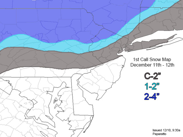
_________________
_______________________________________________________________________________________________________
CLICK HERE to view NJ Strong Snowstorm Classifications

Frank_Wx- Godzilla Seeker

- Posts : 21305
Reputation : 328
Join date : 2013-01-05
Age : 31
Location : Jersey City, NJ -

Re: December 11th-12th Storm Update #2
![]() by Frank_Wx Sat Dec 10, 2016 10:00 am
by Frank_Wx Sat Dec 10, 2016 10:00 am
Here is the timing:
Snow showers will break out across the area between 1-3pm Sunday afternoon. The precipitation will not become steady until after Midnight early Monday morning. By 3-4am, those in the grey shaded area should turn to rain and stay remain for the remainder of the storm. Between 4-7am, those in the dark blue shaded area should see their steadiest snow. By 10-11am, the precipitation should shut off everywhere.
Snow showers will break out across the area between 1-3pm Sunday afternoon. The precipitation will not become steady until after Midnight early Monday morning. By 3-4am, those in the grey shaded area should turn to rain and stay remain for the remainder of the storm. Between 4-7am, those in the dark blue shaded area should see their steadiest snow. By 10-11am, the precipitation should shut off everywhere.
_________________
_______________________________________________________________________________________________________
CLICK HERE to view NJ Strong Snowstorm Classifications
Frank_Wx- Godzilla Seeker
- Posts : 21305
Reputation : 328
Join date : 2013-01-05
Age : 31
Location : Jersey City, NJ -
Re: December 11th-12th Storm Update #2
![]() by frank 638 Sat Dec 10, 2016 10:29 am
by frank 638 Sat Dec 10, 2016 10:29 am
Thanks frank the post you put up I was hoping this would be a snow event but the storm is moving to far north anyway I moving on to the next storm
frank 638- Senior Enthusiast

- Posts : 2824
Reputation : 37
Join date : 2016-01-01
Age : 40
Location : bronx ny


snow247- Pro Enthusiast

- Posts : 2417
Reputation : 0
Join date : 2014-08-27
Location : Mount Ivy, NY - Elevation 545'
Re: December 11th-12th Storm Update #2
![]() by aiannone Sat Dec 10, 2016 2:58 pm
by aiannone Sat Dec 10, 2016 2:58 pm
WWA for 3-6" here in Binghamton, NY
_________________
-Alex Iannone-

aiannone- Senior Enthusiast - Mod

- Posts : 4813
Reputation : 92
Join date : 2013-01-07
Location : Saint James, LI (Northwest Suffolk Co.)
Re: December 11th-12th Storm Update #2
![]() by rb924119 Sat Dec 10, 2016 4:05 pm
by rb924119 Sat Dec 10, 2016 4:05 pm
I think I am reversing my course on a "warmer" storm, and changing my opinion on this event very quickly. As has been the trend this season so far, I think NW NJ, NE PA, and from the mountains of the Mid-Hudson Valley on northward are going to see another over-performer here, as I digest today's suites. First guess to come this evening!
rb924119- Meteorologist

- Posts : 6889
Reputation : 194
Join date : 2013-02-06
Age : 32
Location : Greentown, Pa
Re: December 11th-12th Storm Update #2
![]() by rb924119 Sat Dec 10, 2016 6:36 pm
by rb924119 Sat Dec 10, 2016 6:36 pm
Here's my first call for tomorrow night's event:
Start: 12-3pm Sunday
End: 5-9am Monday
Worst of storm: 12-6am Monday
For areas in blue, snowfall rates of up to 2"/hr will be possible, along with a chance of thundersnow. For all other areas, heavy rain with possible thunder is expected during the worst of the storm.
Any updates will be issued tomorrow.
rb924119- Meteorologist
- Posts : 6889
Reputation : 194
Join date : 2013-02-06
Age : 32
Location : Greentown, Pa
Re: December 11th-12th Storm Update #2
![]() by Quietace Sat Dec 10, 2016 7:08 pm
by Quietace Sat Dec 10, 2016 7:08 pm
Nice map. I would argue Your eastern areas(aka Worcester/Northern Mass) are too low. Given the storm track and evolution of surface temps, p-type issues are marginal until later in the system for those areas. Probably a 2-4 to 4-6 N/S linear gradient rather than the Sw/NE axis you have drawn. Plenty of precip before lower level temps rise for that.rb924119 wrote:Here's my first call for tomorrow night's event:
Start: 12-3pm Sunday
End: 5-9am Monday
Worst of storm: 12-6am Monday
For areas in blue, snowfall rates of up to 2"/hr will be possible, along with a chance of thundersnow. For all other areas, heavy rain with possible thunder is expected during the worst of the storm.
Any updates will be issued tomorrow.

Quietace- Meteorologist - Mod

- Posts : 3687
Reputation : 33
Join date : 2013-01-07
Age : 27
Location : Point Pleasant, NJ
Re: December 11th-12th Storm Update #2
![]() by rb924119 Sat Dec 10, 2016 7:57 pm
by rb924119 Sat Dec 10, 2016 7:57 pm
Quietace wrote:Nice map. I would argue Your eastern areas(aka Worcester/Northern Mass) are too low. Given the storm track and evolution of surface temps, p-type issues are marginal until later in the system for those areas. Probably a 2-4 to 4-6 N/S linear gradient rather than the Sw/NE axis you have drawn. Plenty of precip before lower level temps rise for that.rb924119 wrote:Here's my first call for tomorrow night's event:
Start: 12-3pm Sunday
End: 5-9am Monday
Worst of storm: 12-6am Monday
For areas in blue, snowfall rates of up to 2"/hr will be possible, along with a chance of thundersnow. For all other areas, heavy rain with possible thunder is expected during the worst of the storm.
Any updates will be issued tomorrow.
Thanks! Yeah, I figured that would be a topic of disagreement. The reason I did that is because based on the pressure fields, I'm banking against a straight southerly flow there (which would delay the change in precipitation types), and am instead thinking the wind has a strong easterly component to it. With ocean waters still near 40° off of those coastlines, I feel that it will drive warmer air in faster in those regions than modeling is suggesting. It's just a hunch I have and a theory I'm testing.
rb924119- Meteorologist
- Posts : 6889
Reputation : 194
Join date : 2013-02-06
Age : 32
Location : Greentown, Pa
Re: December 11th-12th Storm Update #2
![]() by Quietace Sat Dec 10, 2016 8:15 pm
by Quietace Sat Dec 10, 2016 8:15 pm
I figured as much. Though, even with a strong easterly wind, which per guidance isn't that intense, that moderating effect only goes travels so far inland. With upper levels supportive into 12z Monday and steady precip falling, that moderating influence should only be subjected to a few miles from the coast. I don't believe you see a early change over(prior to 10z) in those areas except on the near coastal plain and low elevations. There is way too much preip with supportive surface and upper level temperatures to only have a few inches in eastern Mass, especially at the snowfall ratios we will see at the onset of the storm.rb924119 wrote:Quietace wrote:Nice map. I would argue Your eastern areas(aka Worcester/Northern Mass) are too low. Given the storm track and evolution of surface temps, p-type issues are marginal until later in the system for those areas. Probably a 2-4 to 4-6 N/S linear gradient rather than the Sw/NE axis you have drawn. Plenty of precip before lower level temps rise for that.rb924119 wrote:Here's my first call for tomorrow night's event:
Start: 12-3pm Sunday
End: 5-9am Monday
Worst of storm: 12-6am Monday
For areas in blue, snowfall rates of up to 2"/hr will be possible, along with a chance of thundersnow. For all other areas, heavy rain with possible thunder is expected during the worst of the storm.
Any updates will be issued tomorrow.
Thanks! Yeah, I figured that would be a topic of disagreement. The reason I did that is because based on the pressure fields, I'm banking against a straight southerly flow there (which would delay the change in precipitation types), and am instead thinking the wind has a strong easterly component to it. With ocean waters still near 40° off of those coastlines, I feel that it will drive warmer air in faster in those regions than modeling is suggesting. It's just a hunch I have and a theory I'm testing.
Quietace- Meteorologist - Mod
- Posts : 3687
Reputation : 33
Join date : 2013-01-07
Age : 27
Location : Point Pleasant, NJ
Re: December 11th-12th Storm Update #2
![]() by rb924119 Sat Dec 10, 2016 8:37 pm
by rb924119 Sat Dec 10, 2016 8:37 pm
Quietace wrote:I figured as much. Though, even with a strong easterly wind, which per guidance isn't that intense, that moderating effect only goes travels so far inland. With upper levels supportive into 12z Monday and steady precip falling, that moderating influence should only be subjected to a few miles from the coast. I don't believe you see a early change over(prior to 10z) in those areas except on the near coastal plain and low elevations. There is way too much preip with supportive surface and upper level temperatures to only have a few inches in eastern Mass, especially at the snowfall ratios we will see at the onset of the storm.rb924119 wrote:Quietace wrote:Nice map. I would argue Your eastern areas(aka Worcester/Northern Mass) are too low. Given the storm track and evolution of surface temps, p-type issues are marginal until later in the system for those areas. Probably a 2-4 to 4-6 N/S linear gradient rather than the Sw/NE axis you have drawn. Plenty of precip before lower level temps rise for that.rb924119 wrote:Here's my first call for tomorrow night's event:
Start: 12-3pm Sunday
End: 5-9am Monday
Worst of storm: 12-6am Monday
For areas in blue, snowfall rates of up to 2"/hr will be possible, along with a chance of thundersnow. For all other areas, heavy rain with possible thunder is expected during the worst of the storm.
Any updates will be issued tomorrow.
Thanks! Yeah, I figured that would be a topic of disagreement. The reason I did that is because based on the pressure fields, I'm banking against a straight southerly flow there (which would delay the change in precipitation types), and am instead thinking the wind has a strong easterly component to it. With ocean waters still near 40° off of those coastlines, I feel that it will drive warmer air in faster in those regions than modeling is suggesting. It's just a hunch I have and a theory I'm testing.
You're assuming that air remains at the surface. However, suppose that air is lifted from the surface via isentropic forcing as it is advected westward; now you essentially create a warm nose that gets displaced further inland until it finally gets washed out by the factors you highlighted. Basically what I am implying by my first call is that you will end up with an extension of the main warm front that parallels the coast in this region and will allow enough warm air to sneak in aloft to change snowflakes to either snow grains or sleet well before the main front gets in. See what I'm saying? It's something that I think that the modeling may not be picking up on, that's all.
rb924119- Meteorologist
- Posts : 6889
Reputation : 194
Join date : 2013-02-06
Age : 32
Location : Greentown, Pa
Re: December 11th-12th Storm Update #2
![]() by Quietace Sat Dec 10, 2016 8:55 pm
by Quietace Sat Dec 10, 2016 8:55 pm
No, I do in fact understand your point of view. I have been analyzing it myself in my spare time tonight after I saw your map. When I see other peoples forecasts I try and see what they are seeing in there forecast, and if I too see something similar, or if I don't, why do my thoughts differ. Ill have to take a peak in the Am to see how things are evolving. But for now back to studying for finalsrb924119 wrote:Quietace wrote:I figured as much. Though, even with a strong easterly wind, which per guidance isn't that intense, that moderating effect only goes travels so far inland. With upper levels supportive into 12z Monday and steady precip falling, that moderating influence should only be subjected to a few miles from the coast. I don't believe you see a early change over(prior to 10z) in those areas except on the near coastal plain and low elevations. There is way too much preip with supportive surface and upper level temperatures to only have a few inches in eastern Mass, especially at the snowfall ratios we will see at the onset of the storm.rb924119 wrote:Quietace wrote:Nice map. I would argue Your eastern areas(aka Worcester/Northern Mass) are too low. Given the storm track and evolution of surface temps, p-type issues are marginal until later in the system for those areas. Probably a 2-4 to 4-6 N/S linear gradient rather than the Sw/NE axis you have drawn. Plenty of precip before lower level temps rise for that.rb924119 wrote:Here's my first call for tomorrow night's event:
Start: 12-3pm Sunday
End: 5-9am Monday
Worst of storm: 12-6am Monday
For areas in blue, snowfall rates of up to 2"/hr will be possible, along with a chance of thundersnow. For all other areas, heavy rain with possible thunder is expected during the worst of the storm.
Any updates will be issued tomorrow.
Thanks! Yeah, I figured that would be a topic of disagreement. The reason I did that is because based on the pressure fields, I'm banking against a straight southerly flow there (which would delay the change in precipitation types), and am instead thinking the wind has a strong easterly component to it. With ocean waters still near 40° off of those coastlines, I feel that it will drive warmer air in faster in those regions than modeling is suggesting. It's just a hunch I have and a theory I'm testing.
You're assuming that air remains at the surface. However, suppose that air is lifted from the surface via isentropic forcing as it is advected westward; now you essentially create a warm nose that gets displaced further inland until it finally gets washed out by the factors you highlighted. Basically what I am implying by my first call is that you will end up with an extension of the main warm front that parallels the coast in this region and will allow enough warm air to sneak in aloft to change snowflakes to either snow grains or sleet well before the main front gets in. See what I'm saying? It's something that I think that the modeling may not be picking up on, that's all.
Quietace- Meteorologist - Mod
- Posts : 3687
Reputation : 33
Join date : 2013-01-07
Age : 27
Location : Point Pleasant, NJ
rb924119- Meteorologist
- Posts : 6889
Reputation : 194
Join date : 2013-02-06
Age : 32
Location : Greentown, Pa
Re: December 11th-12th Storm Update #2
![]() by NjWeatherGuy Sun Dec 11, 2016 12:32 am
by NjWeatherGuy Sun Dec 11, 2016 12:32 am
It looks like a very quick changeover situation due to position of the main LP and HPs, a few hours of snow and then heavy rain to wash it away, hardly see the need for a WWA in my area in the coastal plain, havent seen the map but I assume I'm on the extreme southern periphery of the advisory and it is possible to be dropped when it wont meet criteria. Im thinking C-1 for most of us, increasing amounts as you go north and up in elevation. There cold air will hang on longer but eventually we will pretty much all go to rain unless you're wayyyy upstate. However interestingly, the CMC, a historically warm, but unfortunately garbage model, has consistently shown cold air hanging on longer and maintaining snow thru 12z to my county (Somerset) while other guidance, GFS, NAM has changeover to rain by 6z. NAVGEM seems to have trended to this warmer soln as well after initally being CMC like and a bit colder. Not sure exactly what the ECM shows but it looks warmer (in line with others) as well.

NjWeatherGuy- Advanced Forecaster

- Posts : 4100
Reputation : 28
Join date : 2013-01-06
Location : Belle Mead, NJ
Re: December 11th-12th Storm Update #2
![]() by NjWeatherGuy Sun Dec 11, 2016 5:00 am
by NjWeatherGuy Sun Dec 11, 2016 5:00 am
6z GFS shows nothing for most of NJ... NAM a tick warmer. Still a WWA for what I think will ultimately be nothing but a coating before a quick and much heavier dump of rain.. Wasting cold air here...
NjWeatherGuy- Advanced Forecaster
- Posts : 4100
Reputation : 28
Join date : 2013-01-06
Location : Belle Mead, NJ
Re: December 11th-12th Storm Update #2
![]() by sroc4 Sun Dec 11, 2016 6:06 am
by sroc4 Sun Dec 11, 2016 6:06 am
Its been hard for me to get involved in the discussion when I know there isn't much of a chance, although not zero, for the coastal plain to see anything accumulate. Ill be happy to see flakes fly.
_________________
"In weather and in life, there's no winning and losing; there's only winning and learning."
WINTER 2012/2013 TOTALS 43.65"WINTER 2017/2018 TOTALS 62.85" WINTER 2022/2023 TOTALS 4.9"
WINTER 2013/2014 TOTALS 64.85"WINTER 2018/2019 TOTALS 14.25" WINTER 2023/2024 TOTALS 13.1"
WINTER 2014/2015 TOTALS 71.20"WINTER 2019/2020 TOTALS 6.35"
WINTER 2015/2016 TOTALS 35.00"WINTER 2020/2021 TOTALS 37.75"
WINTER 2016/2017 TOTALS 42.25"WINTER 2021/2022 TOTALS 31.65"

sroc4- Admin
- Posts : 8331
Reputation : 301
Join date : 2013-01-07
Location : Wading River, LI
Re: December 11th-12th Storm Update #2
![]() by nutleyblizzard Sun Dec 11, 2016 6:14 am
by nutleyblizzard Sun Dec 11, 2016 6:14 am
Yep. Lack of a western ridge to slow down the flow along with a hostile atlantic gives us cold air followed by rain then back to cold. Wash, rinse, repeat. Frustrating pattern indeed. Damn La Nina. Hope pattern becomes more conducive for snow soon.NjWeatherGuy wrote:6z GFS shows nothing for most of NJ... NAM a tick warmer. Still a WWA for what I think will ultimately be nothing but a coating before a quick and much heavier dump of rain.. Wasting cold air here...

nutleyblizzard- Senior Enthusiast
- Posts : 1952
Reputation : 41
Join date : 2014-01-30
Age : 58
Location : Nutley, new jersey
Re: December 11th-12th Storm Update #2
![]() by Frank_Wx Sun Dec 11, 2016 10:11 am
by Frank_Wx Sun Dec 11, 2016 10:11 am
No change to my 1st call snow map. Like mentioned in my disco, areas in blue at elevation could see 6 inches of snow. Warm air will flood the area in the early morning Monday.
_________________
_______________________________________________________________________________________________________
CLICK HERE to view NJ Strong Snowstorm Classifications
Frank_Wx- Godzilla Seeker
- Posts : 21305
Reputation : 328
Join date : 2013-01-05
Age : 31
Location : Jersey City, NJ -
Re: December 11th-12th Storm Update #2
![]() by HeresL Sun Dec 11, 2016 4:08 pm
by HeresL Sun Dec 11, 2016 4:08 pm
Snowing nicely here in West Milford ground already has a thin cover....

HeresL- Posts : 122
Reputation : 0
Join date : 2013-01-20
Location : West Milford, NJ
Re: December 11th-12th Storm Update #2
![]() by Dunnzoo Sun Dec 11, 2016 4:38 pm
by Dunnzoo Sun Dec 11, 2016 4:38 pm
Folks, let's keep the obs for this event in the event thread please, we are posting in three different places 
_________________
Janet
Snowfall winter of 2023-2024 17.5"
Snowfall winter of 2022-2023 6.0"
Snowfall winter of 2021-2022 17.6" 1" sleet 2/25/22
Snowfall winter of 2020-2021 51.1"
Snowfall winter of 2019-2020 8.5"
Snowfall winter of 2018-2019 25.1"
Snowfall winter of 2017-2018 51.9"
Snowfall winter of 2016-2017 45.6"
Snowfall winter of 2015-2016 29.5"
Snowfall winter of 2014-2015 50.55"
Snowfall winter of 2013-2014 66.5"

Dunnzoo- Senior Enthusiast - Mod
- Posts : 4886
Reputation : 68
Join date : 2013-01-11
Age : 62
Location : Westwood, NJ
Permissions in this forum:
You cannot reply to topics in this forum|
|
|