
 Search
Long Range Thread 13.0
Page 39 of 40 •  1 ... 21 ... 38, 39, 40
 ![]()
Re: Long Range Thread 13.0
![]() by Guest Fri Jan 20, 2017 7:00 pm
by Guest Fri Jan 20, 2017 7:00 pm
Hopefully this is only a blip. because with all the hype about the 27th going forward, coming on the heels of missing out on an epic blizzard with this Monday's monster would be crushing to say the least!
Guest- Guest
Re: Long Range Thread 13.0
![]() by Isotherm Sat Jan 21, 2017 1:16 pm
by Isotherm Sat Jan 21, 2017 1:16 pm
The anticipated wave-1 increase via the tropospheric precursor pattern and concomitant MJO propagation support has led to an enhanced convergence of energy at the vortex, resulting in sufficient forcing to temporarily displace the stratospheric vortex from the center of the pole. The vortex will be pushed toward Greenland at 50-10hpa by D 10. However, after which, wave-1 convergence begins to decline, and with no follow-up wave-2 assault, and so the resultant outcome may be a near miss; namely, the reduction of zonal winds at 60N/10hpa to weakly positive levels (no reversal). Right now, it appears the wave driving will be sufficient to induce a mean zonal wind reversal at the top of the atmosphere (1hpa), but not further down. Even in the case that zonal winds are temporarily reversed at 10hpa, there are a couple of significant issues: 1) This potential displacement event will likely not be one which results in the subsequent destruction of the vortex, but rather, a rapid reconsolidation and intensification of the PNJ; and, 2) Even if a SSW event were to occur, based upon my research, this would likely be an ineffectively propagating SSW event. In other words, the significant warming at the upper levels of the atmosphere will not induce meaningful alterations of the z500 northern annular mode.
What the near miss/borderline displacement will effectuate is a weaker stratospheric vortex, making it more susceptible to future assaults. The evolution of the tropospheric pattern is such that wave-2 should begin to increase by day 10, with potentially a robust spike by 2/10. Given an expected weaker vortex, a potent wave-2 attack could possibly induce a more meaningful stratospheric reversal toward mid February. However, of course, at that point, we are approaching late winter, and the effect of stratospheric warming events tends to be less dramatic. But there are examples in the data w/ analogous background conditions to this year which featured mid/late Feb SSW events. And I currently favor late winter (later in Feb into March) for the best opportunity for a genuine negative AO pattern in the troposphere. However, this is only one possibility. If the wave driving doesn’t progress, we could run the early February regime through March.
Now, what is the early February regime? The MJO aided ephemeral alterations with PNA spike and concomitant downstream trough in the East will rapidly transition into a retracted jet / Aleutian ridge / NW US trough pattern by early February – classic La Nina regime.
There will be a transient window 1/28-2/3 for a deep coastal storm on the east coast which could produce snow, when the PNA is conducive. If we do not capitalize on that period, all hope is not lost. I think poleward ridging will develop in the Aleutians given tropical forcing progression and AAM/GWO tendencies. This will force the return of a NW US trough, but if there’s sufficient geopotential height rises extending into the Arctic and/or northeast Greenland from the Scandinavian side, the baroclinic gradient would be sufficiently suppressed to permit a wintry event down to our latitude. If there’s insufficient extension of the poleward ridge, the pattern will be similar to December with February climatology: a snowier pattern for much of New England but not necessarily that good from coastal SNE southward. Overall, Feb 1-15 looks normal to warmer than normal, but not blowtorch. There will be possibilities of snow, but it isn’t a great looking winter pattern. I do believe we will achieve at least one moderate or greater snow event in the 1/28-2/12 period.
Beyond that time, the determinants of a blocky pattern will be contingent upon MJO aid, stratosphere, and other factors. At this point, I would lean toward a continuation of the largely +AO/NAO regime with an initial +PNA transient, leading toward a –EPO/-PNA for most of the first half of February. The weakened state of the stratospheric vortex should permit the neutralization of geopotential heights in the Arctic such that the upcoming few weeks is more favorable than the winter thus far for the possibility of snow. It will favor the Lakes, New England and interior however.
A resurgence of wave-2 in early-mid February could eventually lead to genuine AO/NAO pattern for later Feb-March but that is still highly speculative, and I am not willing to attach significant confidence to the idea just yet.
In sum: it appears to be the type of pattern which will gradually inch us close to my seasonal numbers of 20-26" for NYC. It's not a great pattern for NYC but it could be occasionally "serviceable" with opportunities, given February climatology and sufficient poleward ridging. That's the type of regime which will continue to favor the northern tier / New England. Temperature wise, it looks near normal to above at times at our latitude following the cold shot.
Isotherm- Advanced Forecaster

- Posts : 231
Join date : 2014-09-01 -

Re: Long Range Thread 13.0
![]() by sroc4 Sat Jan 21, 2017 2:52 pm
by sroc4 Sat Jan 21, 2017 2:52 pm
_________________
"In weather and in life, there's no winning and losing; there's only winning and learning."
WINTER 2012/2013 TOTALS 43.65"WINTER 2017/2018 TOTALS 62.85" WINTER 2022/2023 TOTALS 4.9"
WINTER 2013/2014 TOTALS 64.85"WINTER 2018/2019 TOTALS 14.25" WINTER 2023/2024 TOTALS 13.1"
WINTER 2014/2015 TOTALS 71.20"WINTER 2019/2020 TOTALS 6.35"
WINTER 2015/2016 TOTALS 35.00"WINTER 2020/2021 TOTALS 37.75"
WINTER 2016/2017 TOTALS 42.25"WINTER 2021/2022 TOTALS 31.65"

sroc4- Admin

- Posts : 8331
Reputation : 301
Join date : 2013-01-07
Location : Wading River, LI
Re: Long Range Thread 13.0
![]() by Guest Sat Jan 21, 2017 3:51 pm
by Guest Sat Jan 21, 2017 3:51 pm
Guest- Guest
Re: Long Range Thread 13.0
![]() by Isotherm Sat Jan 21, 2017 4:08 pm
by Isotherm Sat Jan 21, 2017 4:08 pm
Isotherm- Advanced Forecaster
- Posts : 231
Reputation : 4
Join date : 2014-09-01
Age : 33
Location : Monmouth County, NJ -
Re: Long Range Thread 13.0
![]() by Guest Sat Jan 21, 2017 4:17 pm
by Guest Sat Jan 21, 2017 4:17 pm
Guest- Guest
Re: Long Range Thread 13.0
![]() by devsman Sat Jan 21, 2017 5:09 pm
by devsman Sat Jan 21, 2017 5:09 pm

devsman- Pro Enthusiast

- Posts : 424
Reputation : 4
Join date : 2014-01-01
Age : 48
Location : merrick, ny (south shore of Long Island)
Re: Long Range Thread 13.0
![]() by CPcantmeasuresnow Sat Jan 21, 2017 5:12 pm
by CPcantmeasuresnow Sat Jan 21, 2017 5:12 pm
devsman wrote:I've already told people at work I believe a groundhog day storm is coming. So a groundhog day storm is coming.
If only it could repeat over and over again just like the Bill Murray Movie.

CPcantmeasuresnow- Wx Statistician Guru

- Posts : 7274
Reputation : 230
Join date : 2013-01-07
Age : 103
Location : Eastern Orange County, NY
Re: Long Range Thread 13.0
![]() by Frank_Wx Sun Jan 22, 2017 8:52 am
by Frank_Wx Sun Jan 22, 2017 8:52 am
I do disagree about temperature departures though. It does not look above normal the 1st to 15th in my eyes.
Average 2M temp anonalies first 5 days of February

Then beyond the 5th depends on the strength / orientation of the WPO/EPO ridge. If strong enough, it will force the baroclinic zone to remain just S&E of our area while muting the SE ridge. We've seen this happen a couple of times already this winter. The EPS maintain colder than normal weather beyond the 5th.
I'm thinking normal to below normal through the 15th.
_________________
_______________________________________________________________________________________________________
CLICK HERE to view NJ Strong Snowstorm Classifications

Frank_Wx- Godzilla Seeker
- Posts : 21305
Reputation : 328
Join date : 2013-01-05
Age : 31
Location : Jersey City, NJ -
Re: Long Range Thread 13.0
![]() by sroc4 Sun Jan 22, 2017 11:27 am
by sroc4 Sun Jan 22, 2017 11:27 am


_________________
"In weather and in life, there's no winning and losing; there's only winning and learning."
WINTER 2012/2013 TOTALS 43.65"WINTER 2017/2018 TOTALS 62.85" WINTER 2022/2023 TOTALS 4.9"
WINTER 2013/2014 TOTALS 64.85"WINTER 2018/2019 TOTALS 14.25" WINTER 2023/2024 TOTALS 13.1"
WINTER 2014/2015 TOTALS 71.20"WINTER 2019/2020 TOTALS 6.35"
WINTER 2015/2016 TOTALS 35.00"WINTER 2020/2021 TOTALS 37.75"
WINTER 2016/2017 TOTALS 42.25"WINTER 2021/2022 TOTALS 31.65"
sroc4- Admin
- Posts : 8331
Reputation : 301
Join date : 2013-01-07
Location : Wading River, LI
Re: Long Range Thread 13.0
![]() by Armando Salvadore Sun Jan 22, 2017 2:36 pm
by Armando Salvadore Sun Jan 22, 2017 2:36 pm


Armando Salvadore- Advanced Forecaster
- Posts : 171
Reputation : 0
Join date : 2016-12-23
Location : Springfield, NJ
Re: Long Range Thread 13.0
![]() by Isotherm Sun Jan 22, 2017 3:05 pm
by Isotherm Sun Jan 22, 2017 3:05 pm
The strat progression doesn't impress me yet. I think what may occur is a near miss - maybe - brief zonal reversal before reconsolidation with this attempt, followed by a stronger hit of wave-1 or potentially wave-2 via the tropospheric precursor pattern as we approach mid Feb. That may be the attempt to fully destroy or split the vortex and induce more effective downwelling. The coupling right now is rather poor, and I see no indication of a tropospheric NAM reversal through early February. The second half of February could see changes in the AO if we succeed in a more effective downward propagation.
This initial attempt looks very borderline to me, and based upon my research, the conditions are unfavorable for quick and efficient downwelling. Still uncertain whether we officially achieve the 10hpa/60N zonal wind reversal with this first attempt 2/1 as well.
Isotherm- Advanced Forecaster
- Posts : 231
Reputation : 4
Join date : 2014-09-01
Age : 33
Location : Monmouth County, NJ -
Re: Long Range Thread 13.0
![]() by Isotherm Sun Jan 22, 2017 6:49 pm
by Isotherm Sun Jan 22, 2017 6:49 pm
Isotherm- Advanced Forecaster
- Posts : 231
Reputation : 4
Join date : 2014-09-01
Age : 33
Location : Monmouth County, NJ -
Re: Long Range Thread 13.0
![]() by Frank_Wx Mon Jan 23, 2017 7:39 am
by Frank_Wx Mon Jan 23, 2017 7:39 am
_________________
_______________________________________________________________________________________________________
CLICK HERE to view NJ Strong Snowstorm Classifications
Frank_Wx- Godzilla Seeker
- Posts : 21305
Reputation : 328
Join date : 2013-01-05
Age : 31
Location : Jersey City, NJ -
Re: Long Range Thread 13.0
![]() by Guest Mon Jan 23, 2017 8:03 am
by Guest Mon Jan 23, 2017 8:03 am
Guest- Guest
Re: Long Range Thread 13.0
![]() by Frank_Wx Mon Jan 23, 2017 11:05 am
by Frank_Wx Mon Jan 23, 2017 11:05 am
TheAresian wrote:Any early indications as to what type of events? Not Godzillas and such, but clippers, Miller B's etc.
The potential exists for Miller A and redeveloping Alberta Clippers.
_________________
_______________________________________________________________________________________________________
CLICK HERE to view NJ Strong Snowstorm Classifications
Frank_Wx- Godzilla Seeker
- Posts : 21305
Reputation : 328
Join date : 2013-01-05
Age : 31
Location : Jersey City, NJ -
Re: Long Range Thread 13.0
![]() by Frank_Wx Mon Jan 23, 2017 12:03 pm
by Frank_Wx Mon Jan 23, 2017 12:03 pm
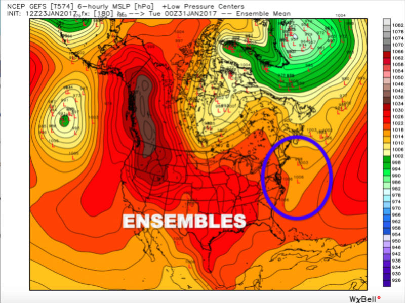
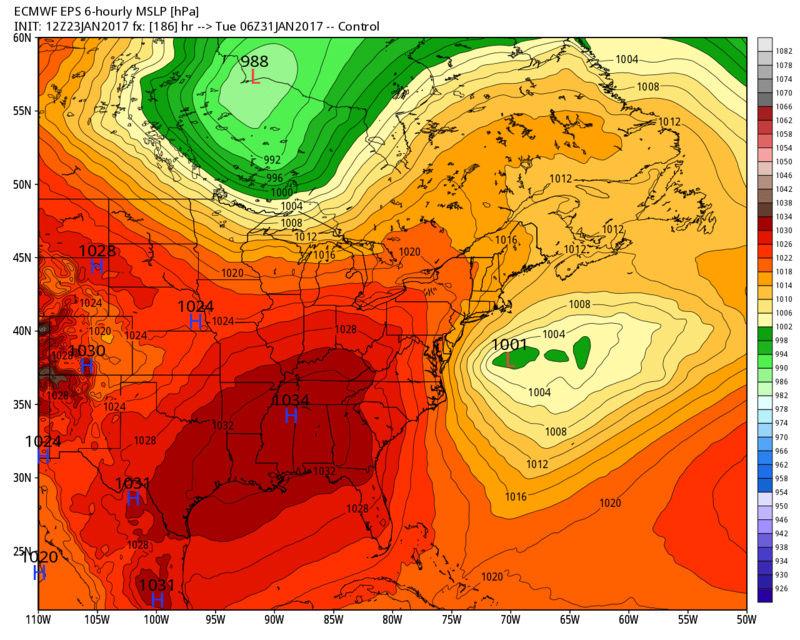
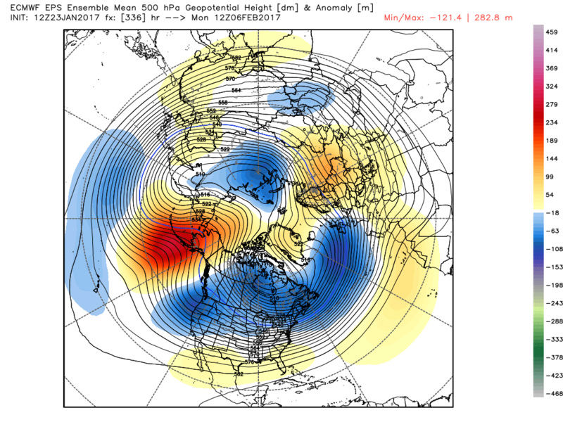
Current - PV over the Pole:

January 27th - Wave 1 warming event underway and beginning to weaken / displace PV toward Europe:

February 8th - PV is still intact but remains displaced off the North Pole. Positive geopotential heights encompass the Arctic.

EPV is forecasted to get more poleward the end of this month. The forecasts keep getting bullish by the day. Reminder that a longer EPV means stronger vertical forcing going from the Trop to the Strat, while an arrow pointing toward the North Pole is more favorable for PV weakening. Also notice how 1hPa mean zonal winds are expected to go negative (easterly) suggesting the very top of the PV will get into an extremely weak state.
At Day 10, the EURO is VERY close to a technical SSWE at 10hPa/60N mean zonal winds.

As stated, I think the warming event will be significant enough to bring changes to our pattern, but it does not look like we'll achieve a SSWE that follows through from the mid to lower levels of the Stratosphere. It will be GREAT if models begin showing another Wave 1 to follow up from the one that will take place this weekend, or a Wave 2. Ultimately, I think that will destroy the PV.
_________________
_______________________________________________________________________________________________________
CLICK HERE to view NJ Strong Snowstorm Classifications
Frank_Wx- Godzilla Seeker
- Posts : 21305
Reputation : 328
Join date : 2013-01-05
Age : 31
Location : Jersey City, NJ -
Re: Long Range Thread 13.0
![]() by Frank_Wx Mon Jan 23, 2017 12:30 pm
by Frank_Wx Mon Jan 23, 2017 12:30 pm
Day 12

Day 16

_________________
_______________________________________________________________________________________________________
CLICK HERE to view NJ Strong Snowstorm Classifications
Frank_Wx- Godzilla Seeker
- Posts : 21305
Reputation : 328
Join date : 2013-01-05
Age : 31
Location : Jersey City, NJ -
Re: Long Range Thread 13.0
![]() by Frank_Wx Mon Jan 23, 2017 12:40 pm
by Frank_Wx Mon Jan 23, 2017 12:40 pm
_________________
_______________________________________________________________________________________________________
CLICK HERE to view NJ Strong Snowstorm Classifications
Frank_Wx- Godzilla Seeker
- Posts : 21305
Reputation : 328
Join date : 2013-01-05
Age : 31
Location : Jersey City, NJ -
Re: Long Range Thread 13.0
![]() by nutleyblizzard Mon Jan 23, 2017 1:15 pm
by nutleyblizzard Mon Jan 23, 2017 1:15 pm
The GEFS is looking great for cold and snow too!Frank_Wx wrote:Today's LR 12z GFS gives me a tingly feeling inside.

nutleyblizzard- Senior Enthusiast

- Posts : 1952
Reputation : 41
Join date : 2014-01-30
Age : 57
Location : Nutley, new jersey
Re: Long Range Thread 13.0
![]() by Armando Salvadore Mon Jan 23, 2017 3:53 pm
by Armando Salvadore Mon Jan 23, 2017 3:53 pm
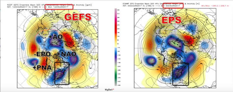
I took the 12z GEFS and 0z EPS and took their respective tropical forcing forecasts because their is some discrepancy between the GEFS and ECMWF. Most likely, we see more of what the GEFS has, and that is we go from a weak phase 2 into a transient base state MC wave, then an initialization of a MJO wave back into the western Hemisphere.
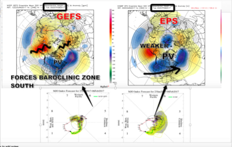
Now check this out, if we look at the 12z EPS, we now see the EPS latching onto the 12z GEFS idea and that is a much poleward and stronger ridge centered over the Aleutians down below!By the way, we do see a jet retraction as Tom alluded too and pacific wave break which will cause the anticyclone over the west coast and Alaska domain to retrograde. Ensembles are hinting at that connection of the Aleutian ridge and Scandinavia ridge, which would direct the TPV further south. Already have changes on the 12z EPS.
Armando Salvadore- Advanced Forecaster
- Posts : 171
Reputation : 0
Join date : 2016-12-23
Location : Springfield, NJ
Re: Long Range Thread 13.0
![]() by billg315 Mon Jan 23, 2017 4:07 pm
by billg315 Mon Jan 23, 2017 4:07 pm

billg315- Advanced Forecaster - Mod

- Posts : 4461
Reputation : 185
Join date : 2015-01-24
Age : 50
Location : Flemington, NJ
Re: Long Range Thread 13.0
![]() by Armando Salvadore Mon Jan 23, 2017 4:21 pm
by Armando Salvadore Mon Jan 23, 2017 4:21 pm
billg315 wrote:So does that mean we're going into an MJO phase 8 and 1 around this time frame, and is that what we're looking for in terms of a better chance at east coast trough/storms? (sorry if this is a dumb question, I'm trying to learn more of these long-range factors that we watch, so I may occasionally ask dumb questions).
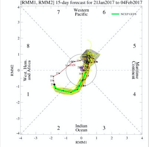
Don't be sorry for asking! Currently, we're in a phase 1 signal and soon to be in phase 2 (indian ocean). Hovmollers and RMM indices indicate that we see a transient MJO wave disperse before igniting again in the western hemisphere and west pacific by the first week of Feb. Sometimes, the forecasts on those RMM plots may be wrong because of the destructive interference from the la Nina maritime continent standing wave. Any propagation of the MJO in the west pacific supports a poleward Aluetian ridge to extend and if it can punch into the Arctic circle, we'd see more influence of the polar vortex to push further south thus pushing the baroclinic zone south as mentioned several times.
Armando Salvadore- Advanced Forecaster
- Posts : 171
Reputation : 0
Join date : 2016-12-23
Location : Springfield, NJ
Re: Long Range Thread 13.0
![]() by billg315 Mon Jan 23, 2017 4:23 pm
by billg315 Mon Jan 23, 2017 4:23 pm
Armando Salvadore wrote:billg315 wrote:So does that mean we're going into an MJO phase 8 and 1 around this time frame, and is that what we're looking for in terms of a better chance at east coast trough/storms? (sorry if this is a dumb question, I'm trying to learn more of these long-range factors that we watch, so I may occasionally ask dumb questions).
Don't be sorry for asking! Currently, we're in a phase 1 signal and soon to be in phase 2 (indian ocean). Hovmollers and RMM indices indicate that we see a transient MJO wave disperse before igniting again in the western hemisphere and west pacific by the first week of Feb. Sometimes, the forecasts on those RMM plots may be wrong because of the destructive interference from the la Nina maritime continent standing wave. Any propagation of the MJO in the west pacific supports a poleward Aluetian ridge to extend and if it can punch into the Arctic circle, we'd see more influence of the polar vortex to push further south thus pushing the baroclinic zone south as mentioned several times.
Got it (in the big picture sense, haha) Thank you!
billg315- Advanced Forecaster - Mod
- Posts : 4461
Reputation : 185
Join date : 2015-01-24
Age : 50
Location : Flemington, NJ
Re: Long Range Thread 13.0
![]() by Snow88 Mon Jan 23, 2017 5:42 pm
by Snow88 Mon Jan 23, 2017 5:42 pm
168 hours
222 hours

Snow88- Senior Enthusiast
- Posts : 2193
Reputation : 4
Join date : 2013-01-09
Age : 35
Location : Brooklyn, NY
Re: Long Range Thread 13.0
![]() by jmanley32 Mon Jan 23, 2017 7:14 pm
by jmanley32 Mon Jan 23, 2017 7:14 pm

jmanley32- Senior Enthusiast
- Posts : 20512
Reputation : 108
Join date : 2013-12-12
Age : 42
Location : Yonkers, NY
Re: Long Range Thread 13.0
![]() by aiannone Mon Jan 23, 2017 7:46 pm
by aiannone Mon Jan 23, 2017 7:46 pm
_________________
-Alex Iannone-

aiannone- Senior Enthusiast - Mod
- Posts : 4813
Reputation : 92
Join date : 2013-01-07
Location : Saint James, LI (Northwest Suffolk Co.)
Page 39 of 40 • 1 ... 21 ... 38, 39, 40 ![]()
|
|
|