
 Search
01/14 Light Snow Observations & Discussions
Page 4 of 9 •  1, 2, 3, 4, 5, 6, 7, 8, 9
 ![]()
Re: 01/14 Light Snow Observations & Discussions
![]() by algae888 Mon Jan 09, 2017 4:55 pm
by algae888 Mon Jan 09, 2017 4:55 pm
here ya go jon...jmanley32 wrote:Does anyone have snow maps for euro so we can see what areas are show 3 to 6.

algae888- Advanced Forecaster

- Posts : 5311
Join date : 2013-02-05
Re: 01/14 Light Snow Observations & Discussions
![]() by Frank_Wx Mon Jan 09, 2017 5:14 pm
by Frank_Wx Mon Jan 09, 2017 5:14 pm
Frank_Wx- Godzilla Seeker

- Posts : 21305
Join date : 2013-01-05 -

Re: 01/14 Light Snow Observations & Discussions
![]() by jmanley32 Mon Jan 09, 2017 5:48 pm
by jmanley32 Mon Jan 09, 2017 5:48 pm
not bad for u and I if tgat were to pan out. Does that include anything from tues or is tues look like mostly rain? Frank had mentioned in his 1st post that this had the potential for heavy snow and even thundersnow. Is a big storm still possible or bc it's two waves is it go look more like this?algae888 wrote:here ya go jon...jmanley32 wrote:Does anyone have snow maps for euro so we can see what areas are show 3 to 6.

jmanley32- Senior Enthusiast

- Posts : 20512
Reputation : 108
Join date : 2013-12-12
Age : 42
Location : Yonkers, NY
Re: 01/14 Light Snow Observations & Discussions
![]() by billg315 Mon Jan 09, 2017 8:27 pm
by billg315 Mon Jan 09, 2017 8:27 pm

billg315- Advanced Forecaster - Mod

- Posts : 4461
Reputation : 185
Join date : 2015-01-24
Age : 50
Location : Flemington, NJ
Re: 01/14 Light Snow Observations & Discussions
![]() by Joe Snow Mon Jan 09, 2017 8:30 pm
by Joe Snow Mon Jan 09, 2017 8:30 pm
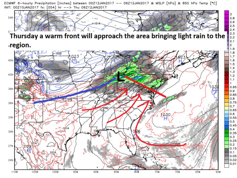
As the day progresses Saturday, looks like precip develops to
the west and approaches the area as warm air rides over a frontal
boundary. This could pose wintry precip issues, possible snow
initially as cold air remains in place per latest GFS and ECMWF. A
passing wave of low pressure tracks south and east Saturday night
into Sunday, then more precip should approach Sunday night into
Monday as upstream trough begins to move eastward. Assuming an
increase in warm air aloft, this round of precip could be icy, with
freezing rain a possibility for portions of the area until sfc temps
warm during the day Monday.

Joe Snow- Pro Enthusiast

- Posts : 924
Reputation : 7
Join date : 2014-02-12
Age : 62
Location : Sanford Florida, Fmrly Kings Park, NY
Re: 01/14 Light Snow Observations & Discussions
![]() by billg315 Mon Jan 09, 2017 8:37 pm
by billg315 Mon Jan 09, 2017 8:37 pm
billg315- Advanced Forecaster - Mod
- Posts : 4461
Reputation : 185
Join date : 2015-01-24
Age : 50
Location : Flemington, NJ
Re: 01/14 Light Snow Observations & Discussions
![]() by Snow88 Mon Jan 09, 2017 9:12 pm
by Snow88 Mon Jan 09, 2017 9:12 pm
billg315 wrote:I just don't see how we get enough cold air entrenched here Saturday to keep this warm overrunning as frozen precip for a long period. It seems like a quick shot of colder air Saturday quickly getting displaced by warm air ahead of two systems to our west.
1040+ high
THat's how

Snow88- Senior Enthusiast
- Posts : 2193
Reputation : 4
Join date : 2013-01-09
Age : 35
Location : Brooklyn, NY
Re: 01/14 Light Snow Observations & Discussions
![]() by billg315 Mon Jan 09, 2017 9:33 pm
by billg315 Mon Jan 09, 2017 9:33 pm
billg315- Advanced Forecaster - Mod
- Posts : 4461
Reputation : 185
Join date : 2015-01-24
Age : 50
Location : Flemington, NJ
Re: 01/14 Light Snow Observations & Discussions
![]() by amugs Mon Jan 09, 2017 10:39 pm
by amugs Mon Jan 09, 2017 10:39 pm

_________________
Mugs
AKA:King: Snow Weenie
Self Proclaimed
WINTER 2014-15 : 55.12" +.02 for 6 coatings (avg. 35")
WINTER 2015-16 Total - 29.8" (Avg 35")
WINTER 2016-17 : 39.5" so far

amugs- Advanced Forecaster - Mod
- Posts : 15091
Reputation : 213
Join date : 2013-01-07
Age : 54
Location : Hillsdale,NJ
Re: 01/14 Light Snow Observations & Discussions
![]() by Joe Snow Mon Jan 09, 2017 10:50 pm
by Joe Snow Mon Jan 09, 2017 10:50 pm
Joe Snow- Pro Enthusiast
- Posts : 924
Reputation : 7
Join date : 2014-02-12
Age : 62
Location : Sanford Florida, Fmrly Kings Park, NY
Re: 01/14 Light Snow Observations & Discussions
![]() by Frank_Wx Mon Jan 09, 2017 11:06 pm
by Frank_Wx Mon Jan 09, 2017 11:06 pm
_________________
_______________________________________________________________________________________________________
CLICK HERE to view NJ Strong Snowstorm Classifications

Frank_Wx- Godzilla Seeker
- Posts : 21305
Reputation : 328
Join date : 2013-01-05
Age : 31
Location : Jersey City, NJ -
Re: 01/14 Light Snow Observations & Discussions
![]() by Frank_Wx Mon Jan 09, 2017 11:12 pm
by Frank_Wx Mon Jan 09, 2017 11:12 pm
_________________
_______________________________________________________________________________________________________
CLICK HERE to view NJ Strong Snowstorm Classifications
Frank_Wx- Godzilla Seeker
- Posts : 21305
Reputation : 328
Join date : 2013-01-05
Age : 31
Location : Jersey City, NJ -
Re: 01/14 Light Snow Observations & Discussions
![]() by Frank_Wx Mon Jan 09, 2017 11:13 pm
by Frank_Wx Mon Jan 09, 2017 11:13 pm

_________________
_______________________________________________________________________________________________________
CLICK HERE to view NJ Strong Snowstorm Classifications
Frank_Wx- Godzilla Seeker
- Posts : 21305
Reputation : 328
Join date : 2013-01-05
Age : 31
Location : Jersey City, NJ -
Re: 01/14 Light Snow Observations & Discussions
![]() by Frank_Wx Mon Jan 09, 2017 11:17 pm
by Frank_Wx Mon Jan 09, 2017 11:17 pm
_________________
_______________________________________________________________________________________________________
CLICK HERE to view NJ Strong Snowstorm Classifications
Frank_Wx- Godzilla Seeker
- Posts : 21305
Reputation : 328
Join date : 2013-01-05
Age : 31
Location : Jersey City, NJ -
Re: 01/14 Light Snow Observations & Discussions
![]() by jrollins628 Mon Jan 09, 2017 11:32 pm
by jrollins628 Mon Jan 09, 2017 11:32 pm
jrollins628- Posts : 38
Reputation : 0
Join date : 2016-10-05
Re: 01/14 Light Snow Observations & Discussions
![]() by rb924119 Tue Jan 10, 2017 7:44 am
by rb924119 Tue Jan 10, 2017 7:44 am
rb924119- Meteorologist

- Posts : 6889
Reputation : 194
Join date : 2013-02-06
Age : 32
Location : Greentown, Pa
Re: 01/14 Light Snow Observations & Discussions
![]() by Grselig Tue Jan 10, 2017 8:23 am
by Grselig Tue Jan 10, 2017 8:23 am
rb924119 wrote:Video coming soon!! I can't contain my excitement, I'm sorry. I LOVE what I'm seeing
I wish there was a "Like" button!

Grselig- Senior Enthusiast
- Posts : 1408
Reputation : 140
Join date : 2013-03-04
Age : 54
Location : Wayne NJ
Re: 01/14 Light Snow Observations & Discussions
![]() by Guest Tue Jan 10, 2017 8:39 am
by Guest Tue Jan 10, 2017 8:39 am
rb924119 wrote:Video coming soon!! I can't contain my excitement, I'm sorry. I LOVE what I'm seeing
Can't wait kid!!! The NWS is only showing about .33 qpf. max so I hope what you see verifies. FIRE ME UP!!!!

Guest- Guest
Re: 01/14 Light Snow Observations & Discussions
![]() by amugs Tue Jan 10, 2017 9:38 am
by amugs Tue Jan 10, 2017 9:38 am
The vorts are not phasing - check so we dont have a strong phased system to bully the HP out.
Small piece seem to be ejecting out of teh SW like little kids being sent the bathroom during bathroom break - teacher analogy.
Don't panic casue things are South and may trend a bit that way - these overrunning events do trend North - liking where we are at. Not like 2014 February different set up - no PV squashing everything. Need to keep the small lp or waves ejecting out of the south west. As Frank and sroc said nothing strong or it cuts, weak is best for us at this point. R/S line going to be a N to South set up and I am liking the Driscoll Bridge area in NJ +/- 15 miles and take a line latitudinally for this (just a guess at this point with location of r/s line).
RAY is excited so hope he does as good as the last storm - HAHAHAHA luv you kid bustin chops - you got snuckered by that SW in the SW that pumped the PNA - just like that Meso low on the Dec 17th storm - greatest day of the year me bday hahaha).
Bring it home RAY we have our trust in you - IRWT!! Look forward to this video.
Syo forget QPF this far out once we get to within 36 hours then we should start this talk imo. Nice to look at though indeed.
_________________
Mugs
AKA:King: Snow Weenie
Self Proclaimed
WINTER 2014-15 : 55.12" +.02 for 6 coatings (avg. 35")
WINTER 2015-16 Total - 29.8" (Avg 35")
WINTER 2016-17 : 39.5" so far
amugs- Advanced Forecaster - Mod
- Posts : 15091
Reputation : 213
Join date : 2013-01-07
Age : 54
Location : Hillsdale,NJ
Re: 01/14 Light Snow Observations & Discussions
![]() by weatherwatchermom Tue Jan 10, 2017 9:48 am
by weatherwatchermom Tue Jan 10, 2017 9:48 am

weatherwatchermom- Senior Enthusiast
- Posts : 3730
Reputation : 77
Join date : 2014-11-25
Age : 60
Location : Hazlet Township, NJ
Re: 01/14 Light Snow Observations & Discussions
![]() by Guest Tue Jan 10, 2017 10:12 am
by Guest Tue Jan 10, 2017 10:12 am
weatherwatchermom wrote:looking forward to seeing the video and where the cut off will be..I am 12 miles South of the Driscoll Bridge...(we have had our share...but of course want more!!)...is this event Sunday?
SELFISH!!!
Guest- Guest
Re: 01/14 Light Snow Observations & Discussions
![]() by RJB8525 Tue Jan 10, 2017 11:14 am
by RJB8525 Tue Jan 10, 2017 11:14 am
weatherwatchermom wrote:looking forward to seeing the video and where the cut off will be..I am 12 miles South of the Driscoll Bridge...(we have had our share...but of course want more!!)...is this event Sunday?
no no no, this storm definitely has to hit NW lol

RJB8525- Senior Enthusiast
- Posts : 1994
Reputation : 28
Join date : 2013-02-06
Age : 38
Location : Hackettstown, NJ
Re: 01/14 Light Snow Observations & Discussions
![]() by sroc4 Tue Jan 10, 2017 11:31 am
by sroc4 Tue Jan 10, 2017 11:31 am
Lets look at the set up.


Now lets look up in the atmosphere. Here is the surface map again combined with 500mb indicating the s/w entering the picture by hr 96.

HR 120:
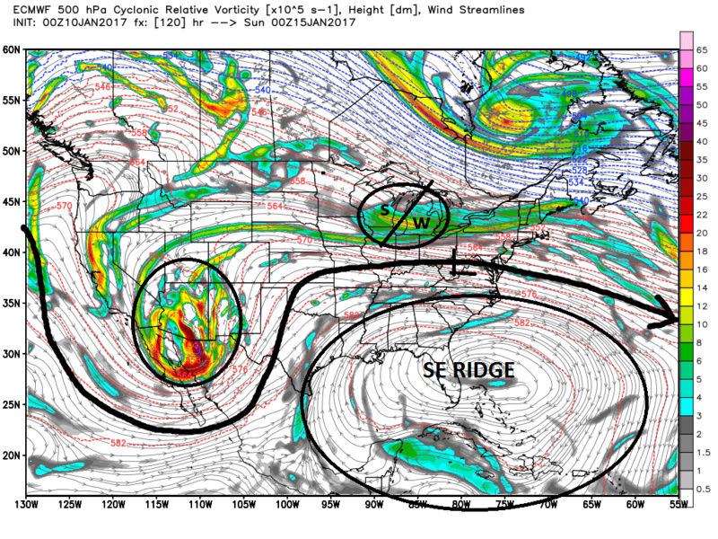

By hr 120 weak LP is developing along the boundary over WV. With the boundary well off the coast the SW flow in front of this LP leads to an over running event where snow breaks out for the area.
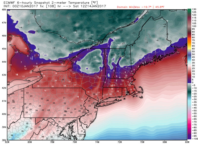
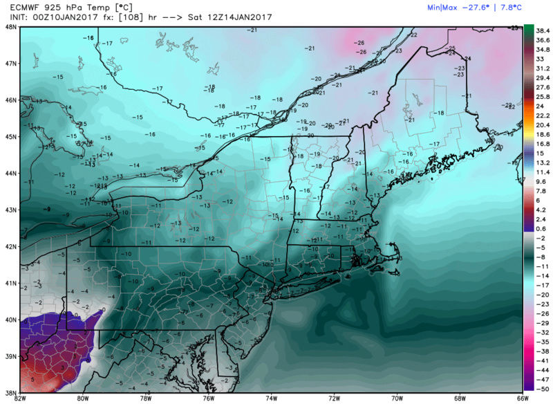
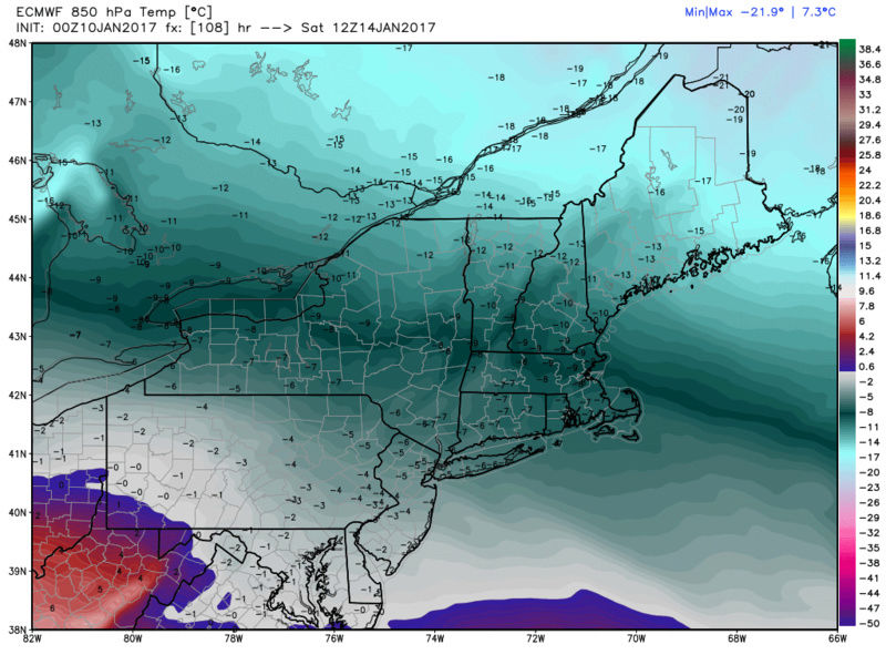
Setting this up, lets quickly look back at the low and mid level temps by Friday into Sat. Once the front moves through by hr 96 temps crash at all levels thanks to the exceptionally strong Can HP. Remember the air that the Can HP will drag down is coming from Canada that is buried in snow. This will be COLD! and it wont be denied by some weak surface LP riding a boundary. Here is Hr 108 setting us up with a fresh injection of fridgid air Friday/Sat for when the s/w and surface LP arrives for Sat/Sun.
SURFACE/925/850
Now as per the 00z Euro verbatim the LP comes off the DELMARVA and pops. Exactly where this comes off the coast will be the key to a mod-big event, a light event, or a dry event.
Here is the 500mb and surface map hr 126

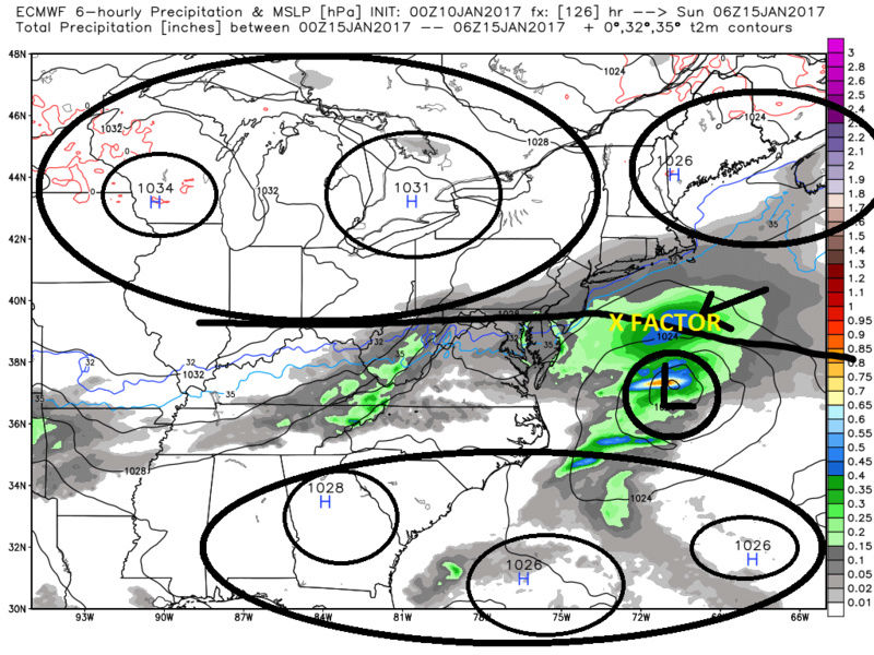
On the surface map notice the area in yellow labled "X FACTOR". This is an area of enhanced precip well N of the surface LP center. I alluded to this in an earlier post. Let me be clear...if this is a mod-big event it will not be due to an intensely deepening LP like we typicaly see with a noreaster developing and undergoing bombogenesis, but rather, this will be an area N of the main LP center that will have intense banding set up in association with a baroclinically (temp gradient) driven meso banding as the LP develops once enhancement from the Atlantic occurs. This WILL Happen. There will be no denying these meso bands of heavy snow. Where exactly they set up will become clear as we get in tight when we know where the LP comes off the coast, and where the best verical velocities set up. Another X Factor which has been mentioned already is the upper level jet streak. IF we get a favorable position it will aid in enhancing the LP development as well as enhancing upward motion aka vertical velocities as well.
Again I want to reiterate I am very confident that this system WILL NOT be rain or mix. It WILL BE snow or dry. Past experience with these set ups leads me to believe the correction as we get in close is to slowly shift the track N a little, but it will keep the LP track coming off the coast S of LI somewhere between the N DELMARVA and Central NJ coast. With the perfect track I can see a max total of 6-12" somewhere. Let me stick my CYA right here. Nothing in weather is a guarantee, so I of course could be wrong with no warm solns. I will leave that possibility at less than 10% at this time. If this changes I will update my ideas.
WE TRACK!!!

_________________
"In weather and in life, there's no winning and losing; there's only winning and learning."
WINTER 2012/2013 TOTALS 43.65"WINTER 2017/2018 TOTALS 62.85" WINTER 2022/2023 TOTALS 4.9"
WINTER 2013/2014 TOTALS 64.85"WINTER 2018/2019 TOTALS 14.25" WINTER 2023/2024 TOTALS 13.1"
WINTER 2014/2015 TOTALS 71.20"WINTER 2019/2020 TOTALS 6.35"
WINTER 2015/2016 TOTALS 35.00"WINTER 2020/2021 TOTALS 37.75"
WINTER 2016/2017 TOTALS 42.25"WINTER 2021/2022 TOTALS 31.65"

sroc4- Admin
- Posts : 8331
Reputation : 301
Join date : 2013-01-07
Location : Wading River, LI
Re: 01/14 Light Snow Observations & Discussions
![]() by rb924119 Tue Jan 10, 2017 11:47 am
by rb924119 Tue Jan 10, 2017 11:47 am
With that, and sorry for the delay, here is my apparently much-anticipated video:
https://drive.google.com/open?id=0Byod2Sk27yNYVDhDSDZwTURtZ0U
As a precaution, my excitement does not peak for this weekend because I don't see it being a "big" event; rather, for what I think lurks beyond it. However, anything wintry, such as this weekend, still gets my heart pumping a bit harder haha Enjoy, and if you have any questions let me know!!
EDIT: Just looked at the PWAT anomalies and there is a chance I could be too low, although I don't know how efficient our setup will be with regard to how well the anomalies are precipitated. Usually, however; when you have PWAT anomalies as high as they are being modeled (see below) that should be a clear RED FLAG. My mistake for not looking at them before I did this video. Still holding my ground for now, but there is certainly potential for this to over-achieve with respect to what I stated above and in my video.

rb924119- Meteorologist
- Posts : 6889
Reputation : 194
Join date : 2013-02-06
Age : 32
Location : Greentown, Pa
Re: 01/14 Light Snow Observations & Discussions
![]() by weatherwatchermom Tue Jan 10, 2017 12:14 pm
by weatherwatchermom Tue Jan 10, 2017 12:14 pm
weatherwatchermom- Senior Enthusiast
- Posts : 3730
Reputation : 77
Join date : 2014-11-25
Age : 60
Location : Hazlet Township, NJ
Re: 01/14 Light Snow Observations & Discussions
![]() by rb924119 Tue Jan 10, 2017 12:20 pm
by rb924119 Tue Jan 10, 2017 12:20 pm
weatherwatchermom wrote:Oh so sorry did not mean to sound selfish...Just wondering how far south coming...Always want the white stuff...Snow is like good glass of tequila always leaving you wanting more..lol. Knew this was a storm for you north and west guys...sorry
He was only kidding haha no need to be sorry! We ALL want the white gold lmao
rb924119- Meteorologist
- Posts : 6889
Reputation : 194
Join date : 2013-02-06
Age : 32
Location : Greentown, Pa
Re: 01/14 Light Snow Observations & Discussions
![]() by sroc4 Tue Jan 10, 2017 12:28 pm
by sroc4 Tue Jan 10, 2017 12:28 pm
rb924119 wrote:Nice, Scott!! Although I will admit that I don't think we see totals THAT high with this; I think more in the 4-8" would be absolute max that we can achieve, with the most likely range in the 3-6" range. Regardless, those are details that we shouldn't worry about yet, and should only be focused on the synoptic overview, as you already said.
With that, and sorry for the delay, here is my apparently much-anticipated video:
https://drive.google.com/open?id=0Byod2Sk27yNYVDhDSDZwTURtZ0U
As a precaution, my excitement does not peak for this weekend because I don't see it being a "big" event; rather, for what I think lurks beyond it. However, anything wintry, such as this weekend, still gets my heart pumping a bit harder haha Enjoy, and if you have any questions let me know!!
EDIT: Just looked at the PWAT anomalies and there is a chance I could be too low, although I don't know how efficient our setup will be with regard to how well the anomalies are precipitated. Usually, however; when you have PWAT anomalies as high as they are being modeled (see below) that should be a clear RED FLAG. My mistake for not looking at them before I did this video. Still holding my ground for now, but there is certainly potential for this to over-achieve with respect to what I stated above and in my video.
Rb Great video! My Max total of 12" may be a bit high but honestly if we get the perfect track and there is jet enhancement to the LP, areas like eastern LI and SE CT into RI and the cape could see a couple/few hrs of intense banding. The dynamics/lift enhancements via thermal gradients between land and SST are always underplayed this far out with overrunning events. I saw it time and time again in winter 2013/14 esp in March. 2-4 3-6 turned out to be 3-6 6-10" in my area time and time again. Maybe 12" is ambitious, but a nice moderate event for someone is def possible.
_________________
"In weather and in life, there's no winning and losing; there's only winning and learning."
WINTER 2012/2013 TOTALS 43.65"WINTER 2017/2018 TOTALS 62.85" WINTER 2022/2023 TOTALS 4.9"
WINTER 2013/2014 TOTALS 64.85"WINTER 2018/2019 TOTALS 14.25" WINTER 2023/2024 TOTALS 13.1"
WINTER 2014/2015 TOTALS 71.20"WINTER 2019/2020 TOTALS 6.35"
WINTER 2015/2016 TOTALS 35.00"WINTER 2020/2021 TOTALS 37.75"
WINTER 2016/2017 TOTALS 42.25"WINTER 2021/2022 TOTALS 31.65"
sroc4- Admin
- Posts : 8331
Reputation : 301
Join date : 2013-01-07
Location : Wading River, LI
Page 4 of 9 • 1, 2, 3, 4, 5, 6, 7, 8, 9 ![]()
|
|
|