
 Search
FRIDAY MARCH 10th 2017: Discussions & Observations
Page 1 of 11 • 1, 2, 3 ... 9, 10, 11 ![]()

FRIDAY MARCH 10th 2017: Discussions & Observations
![]() by sroc4 Thu Mar 09, 2017 7:00 am
by sroc4 Thu Mar 09, 2017 7:00 am
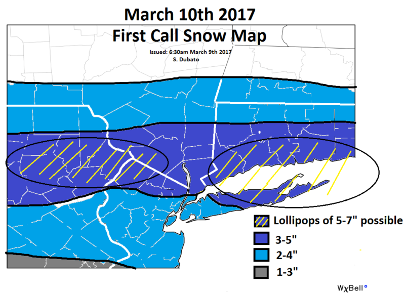
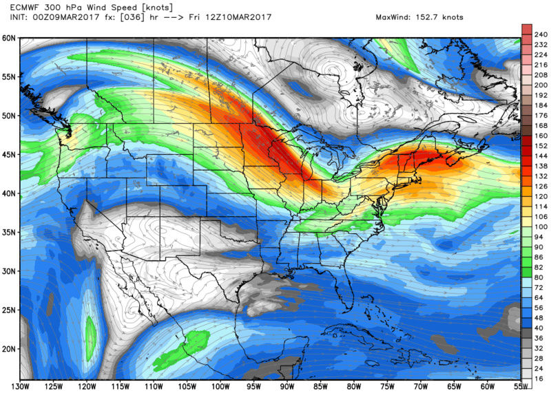
A second feature which appears consistent now on both GFS and Euro is a 300mb jet streak favorably positioned over N NE. The positioning and timing is such that as the surface LP reaches the coast it is within the favorable R Rear Quadrant of the JS which divergence aloft to the N will further enhance vertical motion and deepen the LP more rapidly, but not bomb out, enhancing QPF esp over eastern half of our area.


Additionally in prev posts I alluded to the possibility of a storm track more west to east vs one that maybe took a slight SW to NE trajectory. Latest model data including both globals and now s/r modeling indicates the trough digging more than prev forecasted into the Ohio valley. With such a vigorous vort max associated with the trough and the trough appearing to go at least neutral, but maybe even slight neg, as it approaches the region I suspect the system may end up more robust than people think. This is more of a hunch though so take it with a grain of salt.
Right now given all the above reasoning I think a bust on the low side for some areas is possible. If im going to bust high anywhere it will likely be from I-78 southward through NJ. We shall see. An updated map will be issued tonight if needed.


_________________
"In weather and in life, there's no winning and losing; there's only winning and learning."
WINTER 2012/2013 TOTALS 43.65"WINTER 2017/2018 TOTALS 62.85" WINTER 2022/2023 TOTALS 4.9"
WINTER 2013/2014 TOTALS 64.85"WINTER 2018/2019 TOTALS 14.25" WINTER 2023/2024 TOTALS 13.1"
WINTER 2014/2015 TOTALS 71.20"WINTER 2019/2020 TOTALS 6.35"
WINTER 2015/2016 TOTALS 35.00"WINTER 2020/2021 TOTALS 37.75"
WINTER 2016/2017 TOTALS 42.25"WINTER 2021/2022 TOTALS 31.65"

sroc4- Admin

- Posts : 8331
Reputation : 301
Join date : 2013-01-07
Location : Wading River, LI
Re: FRIDAY MARCH 10th 2017: Discussions & Observations
![]() by SNOW MAN Thu Mar 09, 2017 7:28 am
by SNOW MAN Thu Mar 09, 2017 7:28 am
sroc4 wrote:So here is my first call snowfall map. As I had alluded to in prev posts I believe there will be a fairly robust baroclinic zone with warm Atlantic moisture and temps to the south and the arctic air mass to the N which will enhance vertical motion.
A second feature which appears consistent now on both GFS and Euro is a 300mb jet streak favorably positioned over N NE. The positioning and timing is such that as the surface LP reaches the coast it is within the favorable R Rear Quadrant of the JS which divergence aloft to the N will further enhance vertical motion and deepen the LP more rapidly, but not bomb out, enhancing QPF esp over eastern half of our area.
Additionally in prev posts I alluded to the possibility of a storm track more west to east vs one that maybe took a slight SW to NE trajectory. Latest model data including both globals and now s/r modeling indicates the trough digging more than prev forecasted into the Ohio valley. With such a vigorous vort max associated with the trough and the trough appearing to go at least neutral, but maybe even slight neg, as it approaches the region I suspect the system may end up more robust than people think. This is more of a hunch though so take it with a grain of salt.
Right now given all the above reasoning I think a bust on the low side for some areas is possible. If im going to bust high anywhere it will likely be from I-78 southward through NJ. We shall see. An updated map will be issued tonight if needed.
Thank you. This is much better.

SNOW MAN- Senior Enthusiast

- Posts : 1361
Reputation : 25
Join date : 2013-01-13
Age : 64
Location : Marshalls Creek Pa.
Re: FRIDAY MARCH 10th 2017: Discussions & Observations
![]() by docstox12 Thu Mar 09, 2017 7:55 am
by docstox12 Thu Mar 09, 2017 7:55 am
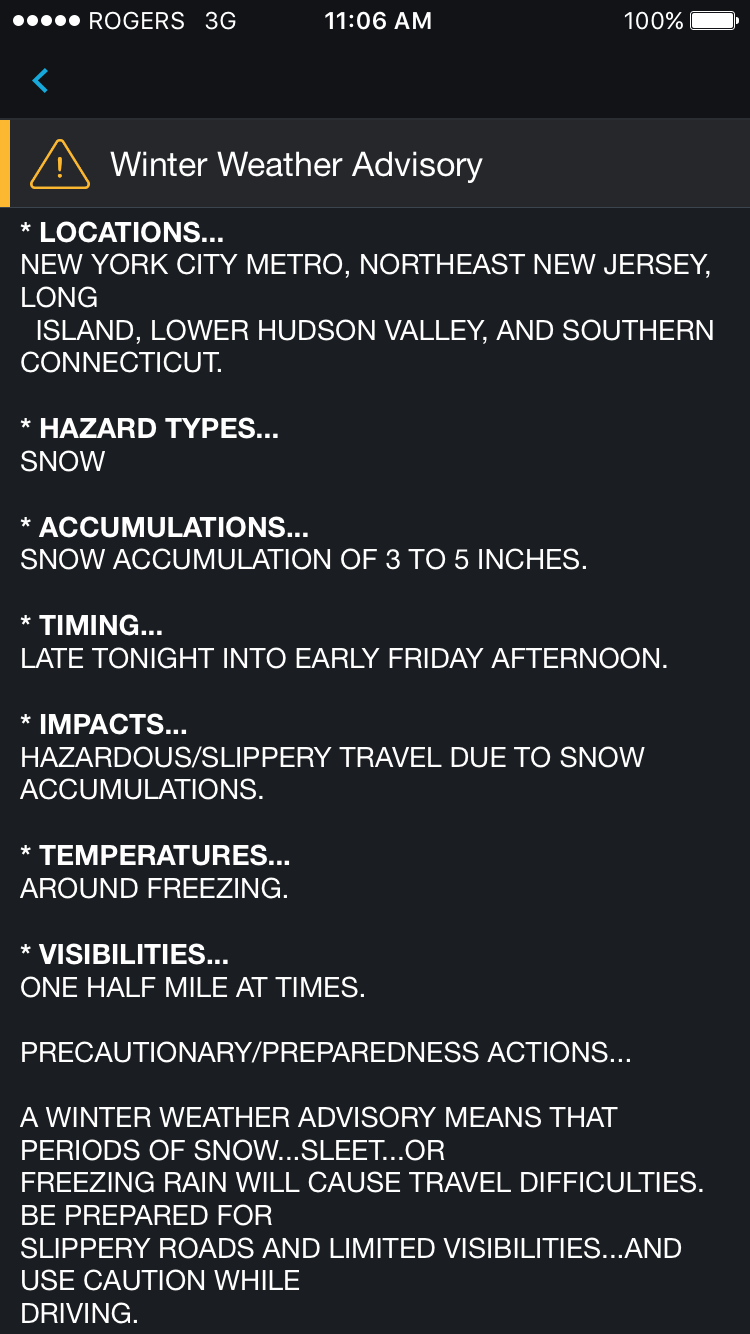
Doc, Lee Goldberg last night said he would bump up his original 1 to 3 area wide to 2 to 4 with some possible 3 to 5 inches in some spots.

docstox12- Wx Statistician Guru

- Posts : 8497
Reputation : 222
Join date : 2013-01-07
Age : 73
Location : Monroe NY
Re: FRIDAY MARCH 10th 2017: Discussions & Observations
![]() by Guest Thu Mar 09, 2017 7:57 am
by Guest Thu Mar 09, 2017 7:57 am
Guest- Guest
Re: FRIDAY MARCH 10th 2017: Discussions & Observations
![]() by Dunnzoo Thu Mar 09, 2017 8:00 am
by Dunnzoo Thu Mar 09, 2017 8:00 am
docstox12 wrote:Good Morning SNOW MAN!!
Doc, Lee Goldberg last night said he would bump up his original 1 to 3 area wide to 2 to 4 with some possible 3 to 5 inches in some spots.
Bill Evans still using 1-3" maps while everyone is bumping up totals
_________________
Janet
Snowfall winter of 2023-2024 17.5"
Snowfall winter of 2022-2023 6.0"
Snowfall winter of 2021-2022 17.6" 1" sleet 2/25/22
Snowfall winter of 2020-2021 51.1"
Snowfall winter of 2019-2020 8.5"
Snowfall winter of 2018-2019 25.1"
Snowfall winter of 2017-2018 51.9"
Snowfall winter of 2016-2017 45.6"
Snowfall winter of 2015-2016 29.5"
Snowfall winter of 2014-2015 50.55"
Snowfall winter of 2013-2014 66.5"

Dunnzoo- Senior Enthusiast - Mod

- Posts : 4882
Reputation : 68
Join date : 2013-01-11
Age : 62
Location : Westwood, NJ
Re: FRIDAY MARCH 10th 2017: Discussions & Observations
![]() by amugs Thu Mar 09, 2017 8:08 am
by amugs Thu Mar 09, 2017 8:08 am
Dunnzoo wrote:docstox12 wrote:Good Morning SNOW MAN!!
Doc, Lee Goldberg last night said he would bump up his original 1 to 3 area wide to 2 to 4 with some possible 3 to 5 inches in some spots.
Bill Evans still using 1-3" maps while everyone is bumping up totals
Good we'll see 4" plus then .............. Warm surfaces amy melt some in the beginning but soundings showing cold air in place up here in NNJ.
GF6Z spit out a warning level storm for NNj and EPA along with LHV. Too bad we dont have an arctic mass in place like we get after the storm or else everyone woudl cash in.

Places like West Milford and Sussex could see major accumulations from this.
_________________
Mugs
AKA:King: Snow Weenie
Self Proclaimed
WINTER 2014-15 : 55.12" +.02 for 6 coatings (avg. 35")
WINTER 2015-16 Total - 29.8" (Avg 35")
WINTER 2016-17 : 39.5" so far

amugs- Advanced Forecaster - Mod
- Posts : 15091
Reputation : 213
Join date : 2013-01-07
Age : 54
Location : Hillsdale,NJ
Re: FRIDAY MARCH 10th 2017: Discussions & Observations
![]() by SNOW MAN Thu Mar 09, 2017 8:25 am
by SNOW MAN Thu Mar 09, 2017 8:25 am
docstox12 wrote:Good Morning SNOW MAN!!
Doc, Lee Goldberg last night said he would bump up his original 1 to 3 area wide to 2 to 4 with some possible 3 to 5 inches in some spots.
Good morning Doc. I know I haven't been on here a lot lately. It's because I have been helping my Mom out lately and with working it's been real busy. Plus I shouldn't even be on here now because our new parent company that bought us doesn't want anybody doing anything but keeping their nose to the grind stone. As they put it to us in a meeting. The only thing we care about is money, we don't care about personal or family issue's or anything else. All we care about is making money. Thankfully I only have less than 5 years to retire. And trust me I can't wait ! I just hope I can keep my job until then. So far they laid off 57 people.
I'm hoping to get a decent snowfall tomorrow in my area and hopefully next weeks storm will come together and hit all of us with some white gold. For me this Winter has been dismal. I've had less than 15 inches of snow so far. But Frank called it last year when he said this Winter was going to be ugly. Take care. I'll try and post when I can.
SNOW MAN- Senior Enthusiast
- Posts : 1361
Reputation : 25
Join date : 2013-01-13
Age : 64
Location : Marshalls Creek Pa.
Re: FRIDAY MARCH 10th 2017: Discussions & Observations
![]() by CPcantmeasuresnow Thu Mar 09, 2017 8:40 am
by CPcantmeasuresnow Thu Mar 09, 2017 8:40 am
When you setup the SCI it was to show the probability of at least an inch of snow from that event in Central Park. I noticed today you ad a 40% chance for the March 14th event with Godzilla next to it. Does this mean there is a 40% chance of a Godzilla or 40% chance at an inch? Big difference of course and inquiring minds want to know.
Thanks

CPcantmeasuresnow- Wx Statistician Guru
- Posts : 7274
Reputation : 230
Join date : 2013-01-07
Age : 103
Location : Eastern Orange County, NY
Re: FRIDAY MARCH 10th 2017: Discussions & Observations
![]() by amugs Thu Mar 09, 2017 8:42 am
by amugs Thu Mar 09, 2017 8:42 am

_________________
Mugs
AKA:King: Snow Weenie
Self Proclaimed
WINTER 2014-15 : 55.12" +.02 for 6 coatings (avg. 35")
WINTER 2015-16 Total - 29.8" (Avg 35")
WINTER 2016-17 : 39.5" so far
amugs- Advanced Forecaster - Mod
- Posts : 15091
Reputation : 213
Join date : 2013-01-07
Age : 54
Location : Hillsdale,NJ
Re: FRIDAY MARCH 10th 2017: Discussions & Observations
![]() by Snow88 Thu Mar 09, 2017 8:51 am
by Snow88 Thu Mar 09, 2017 8:51 am
I do think there will be some accumulations on paved surfaces but mostly on colder surfaces. 2-4 inches look good right now.

Snow88- Senior Enthusiast
- Posts : 2193
Reputation : 4
Join date : 2013-01-09
Age : 35
Location : Brooklyn, NY
Re: FRIDAY MARCH 10th 2017: Discussions & Observations
![]() by amugs Thu Mar 09, 2017 8:55 am
by amugs Thu Mar 09, 2017 8:55 am
Snow88 wrote:Surface temps drop as the precip moves in even in the NYC area
I do think there will be some accumulations on paved surfaces but mostly on colder surfaces. 2-4 inches look good right now.
For teh UHI or Steam generator of NYC - Burbs will see 4-6" maybe pops of 7" in higher elevations.
_________________
Mugs
AKA:King: Snow Weenie
Self Proclaimed
WINTER 2014-15 : 55.12" +.02 for 6 coatings (avg. 35")
WINTER 2015-16 Total - 29.8" (Avg 35")
WINTER 2016-17 : 39.5" so far
amugs- Advanced Forecaster - Mod
- Posts : 15091
Reputation : 213
Join date : 2013-01-07
Age : 54
Location : Hillsdale,NJ
Re: FRIDAY MARCH 10th 2017: Discussions & Observations
![]() by Guest Thu Mar 09, 2017 8:58 am
by Guest Thu Mar 09, 2017 8:58 am
Guest- Guest
Re: FRIDAY MARCH 10th 2017: Discussions & Observations
![]() by Snow88 Thu Mar 09, 2017 9:00 am
by Snow88 Thu Mar 09, 2017 9:00 am
Snow88- Senior Enthusiast
- Posts : 2193
Reputation : 4
Join date : 2013-01-09
Age : 35
Location : Brooklyn, NY
Re: FRIDAY MARCH 10th 2017: Discussions & Observations
![]() by sroc4 Thu Mar 09, 2017 9:01 am
by sroc4 Thu Mar 09, 2017 9:01 am
syosnow94 wrote:Every nap sroc4 puts out always has his house in the "special potential higher amounts area" which he then purposefully extends westbound towards but never quite reaching MBY. Funny how this works
I do not understand what your saying Jimmy:

_________________
"In weather and in life, there's no winning and losing; there's only winning and learning."
WINTER 2012/2013 TOTALS 43.65"WINTER 2017/2018 TOTALS 62.85" WINTER 2022/2023 TOTALS 4.9"
WINTER 2013/2014 TOTALS 64.85"WINTER 2018/2019 TOTALS 14.25" WINTER 2023/2024 TOTALS 13.1"
WINTER 2014/2015 TOTALS 71.20"WINTER 2019/2020 TOTALS 6.35"
WINTER 2015/2016 TOTALS 35.00"WINTER 2020/2021 TOTALS 37.75"
WINTER 2016/2017 TOTALS 42.25"WINTER 2021/2022 TOTALS 31.65"
sroc4- Admin
- Posts : 8331
Reputation : 301
Join date : 2013-01-07
Location : Wading River, LI
Re: FRIDAY MARCH 10th 2017: Discussions & Observations
![]() by Armando Salvadore Thu Mar 09, 2017 9:11 am
by Armando Salvadore Thu Mar 09, 2017 9:11 am

Armando Salvadore- Advanced Forecaster

- Posts : 171
Reputation : 0
Join date : 2016-12-23
Location : Springfield, NJ
Re: FRIDAY MARCH 10th 2017: Discussions & Observations
![]() by Frank_Wx Thu Mar 09, 2017 9:58 am
by Frank_Wx Thu Mar 09, 2017 9:58 am
CPcantmeasuresnow wrote:Question for Frank:
When you setup the SCI it was to show the probability of at least an inch of snow from that event in Central Park. I noticed today you ad a 40% chance for the March 14th event with Godzilla next to it. Does this mean there is a 40% chance of a Godzilla or 40% chance at an inch? Big difference of course and inquiring minds want to know.
Thanks
Still 1"
I just wanted to call it something, but that is kinda confusing. My bad.
_________________
_______________________________________________________________________________________________________
CLICK HERE to view NJ Strong Snowstorm Classifications

Frank_Wx- Godzilla Seeker
- Posts : 21305
Reputation : 328
Join date : 2013-01-05
Age : 31
Location : Jersey City, NJ -

Re: FRIDAY MARCH 10th 2017: Discussions & Observations
![]() by Frank_Wx Thu Mar 09, 2017 9:58 am
by Frank_Wx Thu Mar 09, 2017 9:58 am
_________________
_______________________________________________________________________________________________________
CLICK HERE to view NJ Strong Snowstorm Classifications
Frank_Wx- Godzilla Seeker
- Posts : 21305
Reputation : 328
Join date : 2013-01-05
Age : 31
Location : Jersey City, NJ -
Re: FRIDAY MARCH 10th 2017: Discussions & Observations
![]() by jmanley32 Thu Mar 09, 2017 10:01 am
by jmanley32 Thu Mar 09, 2017 10:01 am
BTW I did not expect it to be so windy today, its loud can hear it through windows, not 81moh like rochester but got a special wx statement for gusts to 40mph, seems like we have had more wind events this winter than snow, wish it was both combined.

jmanley32- Senior Enthusiast
- Posts : 20512
Reputation : 108
Join date : 2013-12-12
Age : 42
Location : Yonkers, NY
Re: FRIDAY MARCH 10th 2017: Discussions & Observations
![]() by Frank_Wx Thu Mar 09, 2017 10:18 am
by Frank_Wx Thu Mar 09, 2017 10:18 am

_________________
_______________________________________________________________________________________________________
CLICK HERE to view NJ Strong Snowstorm Classifications
Frank_Wx- Godzilla Seeker
- Posts : 21305
Reputation : 328
Join date : 2013-01-05
Age : 31
Location : Jersey City, NJ -
Re: FRIDAY MARCH 10th 2017: Discussions & Observations
![]() by docstox12 Thu Mar 09, 2017 10:23 am
by docstox12 Thu Mar 09, 2017 10:23 am
SNOW MAN wrote:docstox12 wrote:Good Morning SNOW MAN!!
Doc, Lee Goldberg last night said he would bump up his original 1 to 3 area wide to 2 to 4 with some possible 3 to 5 inches in some spots.
Good morning Doc. I know I haven't been on here a lot lately. It's because I have been helping my Mom out lately and with working it's been real busy. Plus I shouldn't even be on here now because our new parent company that bought us doesn't want anybody doing anything but keeping their nose to the grind stone. As they put it to us in a meeting. The only thing we care about is money, we don't care about personal or family issue's or anything else. All we care about is making money. Thankfully I only have less than 5 years to retire. And trust me I can't wait ! I just hope I can keep my job until then. So far they laid off 57 people.
I'm hoping to get a decent snowfall tomorrow in my area and hopefully next weeks storm will come together and hit all of us with some white gold. For me this Winter has been dismal. I've had less than 15 inches of snow so far. But Frank called it last year when he said this Winter was going to be ugly. Take care. I'll try and post when I can.
Same here, SNOW MAN, helping my Mom who is 96 two days a week I stay with her.Sorry about the job and their rotten attitudes.Hope you can hang in there and get the hell out in 5 years.Hope you get a couple of good snow events there.Cp and I have lucked out, we're at 600 feet and further east of you.Glad to talk to you good Buddy!
51.8 ( as Lee said, who is gonna think it's going to snow tonight), 32% (very dry) and 29.70 F.
Gotta agree with Armando.This dry air will eat up some of the precip just wetting the column. If I get 2 ,I'll be happy, 5 ecstatic!
docstox12- Wx Statistician Guru
- Posts : 8497
Reputation : 222
Join date : 2013-01-07
Age : 73
Location : Monroe NY
Re: FRIDAY MARCH 10th 2017: Discussions & Observations
![]() by le88kb Thu Mar 09, 2017 10:38 am
by le88kb Thu Mar 09, 2017 10:38 am

le88kb- Posts : 12
Reputation : 0
Join date : 2013-12-12
Location : Pequannock Nj
Re: FRIDAY MARCH 10th 2017: Discussions & Observations
![]() by SoulSingMG Thu Mar 09, 2017 10:59 am
by SoulSingMG Thu Mar 09, 2017 10:59 am

SoulSingMG- Senior Enthusiast
- Posts : 2853
Reputation : 74
Join date : 2013-12-11
Location : Long Island City, NY
Re: FRIDAY MARCH 10th 2017: Discussions & Observations
![]() by amugs Thu Mar 09, 2017 11:02 am
by amugs Thu Mar 09, 2017 11:02 am

_________________
Mugs
AKA:King: Snow Weenie
Self Proclaimed
WINTER 2014-15 : 55.12" +.02 for 6 coatings (avg. 35")
WINTER 2015-16 Total - 29.8" (Avg 35")
WINTER 2016-17 : 39.5" so far
amugs- Advanced Forecaster - Mod
- Posts : 15091
Reputation : 213
Join date : 2013-01-07
Age : 54
Location : Hillsdale,NJ
Re: FRIDAY MARCH 10th 2017: Discussions & Observations
![]() by amugs Thu Mar 09, 2017 11:03 am
by amugs Thu Mar 09, 2017 11:03 am

_________________
Mugs
AKA:King: Snow Weenie
Self Proclaimed
WINTER 2014-15 : 55.12" +.02 for 6 coatings (avg. 35")
WINTER 2015-16 Total - 29.8" (Avg 35")
WINTER 2016-17 : 39.5" so far
amugs- Advanced Forecaster - Mod
- Posts : 15091
Reputation : 213
Join date : 2013-01-07
Age : 54
Location : Hillsdale,NJ
Re: FRIDAY MARCH 10th 2017: Discussions & Observations
![]() by SoulSingMG Thu Mar 09, 2017 11:07 am
by SoulSingMG Thu Mar 09, 2017 11:07 am
SoulSingMG- Senior Enthusiast
- Posts : 2853
Reputation : 74
Join date : 2013-12-11
Location : Long Island City, NY
Page 1 of 11 • 1, 2, 3 ... 9, 10, 11 ![]()
|
|
|