
 Search
Long Range Thread 13.0
Page 1 of 40 • 1, 2, 3 ... 20 ... 40 ![]()

Long Range Thread 13.0
![]() by oldtimer Tue Jan 24, 2017 2:28 pm
by oldtimer Tue Jan 24, 2017 2:28 pm
oldtimer- Senior Enthusiast

- Posts : 1103
Reputation : 14
Join date : 2013-01-16
Age : 78
Location : Port Jefferson Station Suffolk County
Re: Long Range Thread 13.0
![]() by sroc4 Tue Jan 24, 2017 2:42 pm
by sroc4 Tue Jan 24, 2017 2:42 pm
Math23x7 wrote:So much for cold weather in early February...

For comparison here is the EPS for same timeframe..also 850mb Temp Anomalies. Big difference. I don't buy that map at all Mikey at this time.

_________________
"In weather and in life, there's no winning and losing; there's only winning and learning."
WINTER 2012/2013 TOTALS 43.65"WINTER 2017/2018 TOTALS 62.85" WINTER 2022/2023 TOTALS 4.9"
WINTER 2013/2014 TOTALS 64.85"WINTER 2018/2019 TOTALS 14.25" WINTER 2023/2024 TOTALS 13.1"
WINTER 2014/2015 TOTALS 71.20"WINTER 2019/2020 TOTALS 6.35"
WINTER 2015/2016 TOTALS 35.00"WINTER 2020/2021 TOTALS 37.75"
WINTER 2016/2017 TOTALS 42.25"WINTER 2021/2022 TOTALS 31.65"

sroc4- Admin

- Posts : 8331
Reputation : 301
Join date : 2013-01-07
Location : Wading River, LI
Re: Long Range Thread 13.0
![]() by sroc4 Tue Jan 24, 2017 2:44 pm
by sroc4 Tue Jan 24, 2017 2:44 pm
sroc4 wrote:Math23x7 wrote:So much for cold weather in early February...
For comparison here is the EPS for same timeframe..also 850mb Temp Anomalies. Big difference. I don't buy that map at all Mikey at this time.
The reds N of Alaska and into Greenland should be your first clue that that the operational likely wrong.
_________________
"In weather and in life, there's no winning and losing; there's only winning and learning."
WINTER 2012/2013 TOTALS 43.65"WINTER 2017/2018 TOTALS 62.85" WINTER 2022/2023 TOTALS 4.9"
WINTER 2013/2014 TOTALS 64.85"WINTER 2018/2019 TOTALS 14.25" WINTER 2023/2024 TOTALS 13.1"
WINTER 2014/2015 TOTALS 71.20"WINTER 2019/2020 TOTALS 6.35"
WINTER 2015/2016 TOTALS 35.00"WINTER 2020/2021 TOTALS 37.75"
WINTER 2016/2017 TOTALS 42.25"WINTER 2021/2022 TOTALS 31.65"
sroc4- Admin
- Posts : 8331
Reputation : 301
Join date : 2013-01-07
Location : Wading River, LI
Re: Long Range Thread 13.0
![]() by amugs Tue Jan 24, 2017 2:53 pm
by amugs Tue Jan 24, 2017 2:53 pm
Math23x7 wrote:So much for cold weather in early February...
Mike that IMO is not going to happen - we will have arctic air diving into that region per the H5 set up.
You have a -WPO building with a - EPO
Yuo have cold arctic highs sliding down from NW Canada at that time.

You see highest rising over in Alaska, a bridge building over the top into Scandinavia and a trough elongated in the east so where does that warmth come from? There is nothing for th is set up IMO that drives that warmth - SE ridge non existent, PAC JET slow/low as per teh
250 Jet Streak

Look at Alaska

This is more of the look that is reasonable of the GEFS - which are doing a hell of a lot better with teh MJO that than teh euro so the trop forcing will argue for more of this than what yuo have posted.

_________________
Mugs
AKA:King: Snow Weenie
Self Proclaimed
WINTER 2014-15 : 55.12" +.02 for 6 coatings (avg. 35")
WINTER 2015-16 Total - 29.8" (Avg 35")
WINTER 2016-17 : 39.5" so far

amugs- Advanced Forecaster - Mod

- Posts : 15091
Reputation : 213
Join date : 2013-01-07
Age : 54
Location : Hillsdale,NJ
Re: Long Range Thread 13.0
![]() by sroc4 Tue Jan 24, 2017 3:47 pm
by sroc4 Tue Jan 24, 2017 3:47 pm
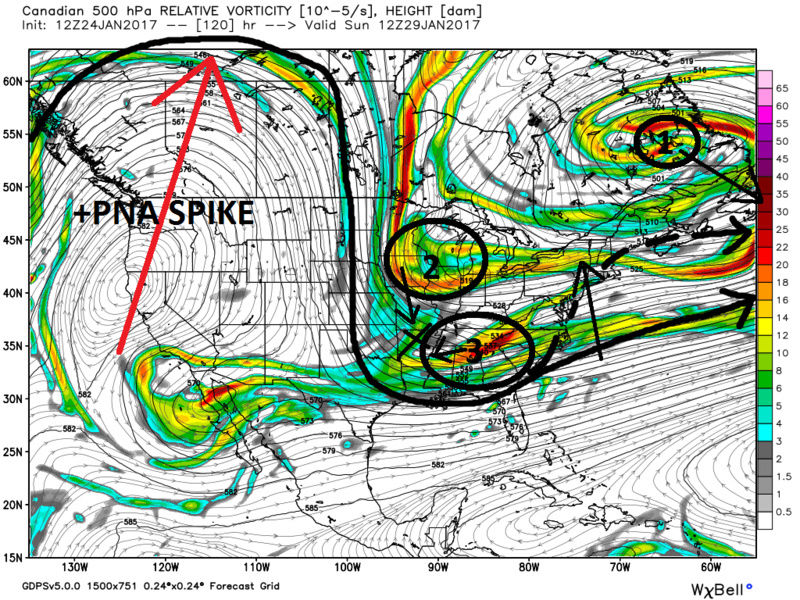
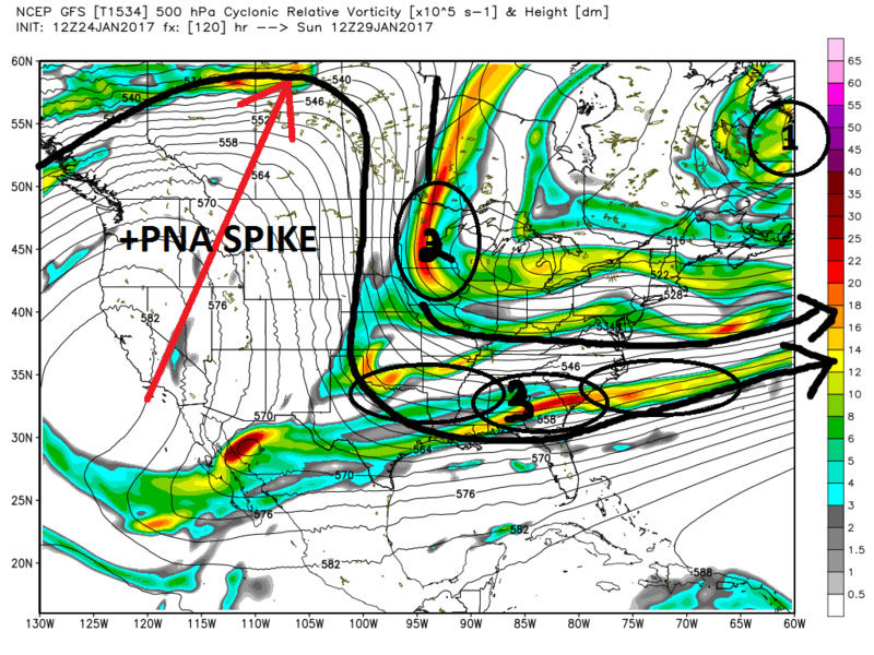
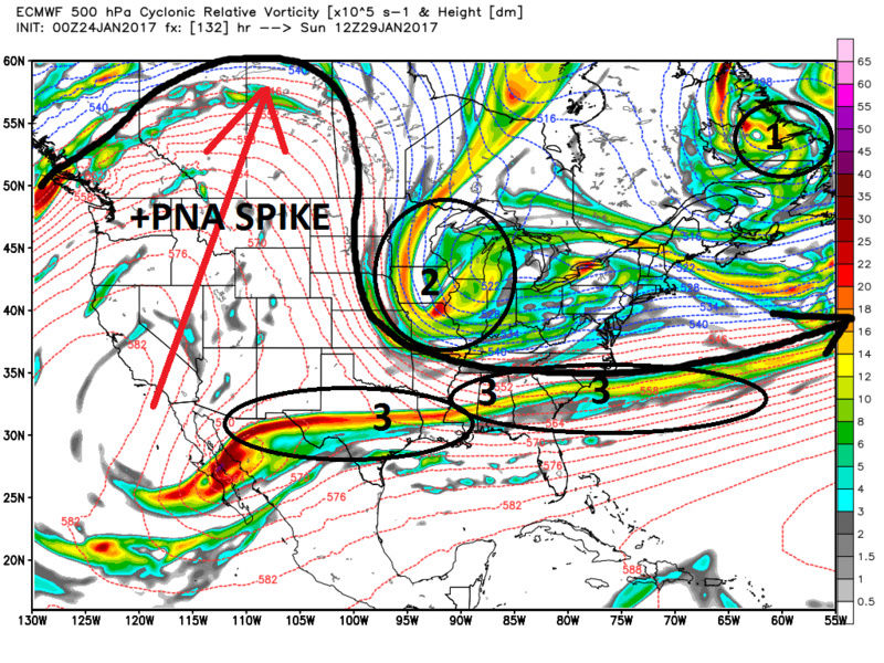
skinsfan1177 wrote:sroc4 wrote:Its not much in the way of the LR any more but we need to keep a close eye on Jan 29th-1st. All three global models are not that far off to a decent system developing when you look at H5. Forget the surface.
The CMC is the closest as of now, with most of the working parts still not yet on the playing field. And once again with every other system with so many working parts it wouldn't take much shifting to create a nice system at the surface. Lets look at the 12z CMC followed by 12zGFS then 00z Euro(12z not out yet as of this write up).
First important piece is cold air. The frontal boundary that swings through around Friday set us up with fresh cold air. All models agree on this.
Next look out west on the map. We have a +PNA spike agreed upon on all three global models the axis of which looks to be in decent position. THIS IS KEY IF THIS THREAT COMES TO LIGHT.
However, look in SE Canada at the area labeled 1. If this upper level system centers itself a tad further SE from wherethe CMC has it verbatim it may act as a 50/50 upper level block.
As of now the area labeled 3 associated with southern stream energy remains stung out and separate from the N energy diving in out of N Canada on the Eastern flank of the +PNA ridge.
Here are a few scenarios we may want to see to have this all come together.
1)IF The energy labeled number 1 trends a tad further S&E it may act as a temporary block to slow down the S Branch. If the N Branch can phase with the the S ( 2 with 3) then a slightly better positioned number 1 would leave room to raise heights out ahead of the phased energy and a LP system has room to come up the coast. If you look at the CMC image above I drew in what that might look like.
2) IF number 2 is a bit faster and it phases with number 3 earlier same deal there may be enough time to raise heights out ahead leaving room for a LP to come up the coast.
Normally one might say that the pattern doesn't support this as the flow remains progressive on the modeling as of now; however, if you look a little more closely the NAO takes a little dip into negative territory between the 26th-28th before headed towards positive/neutral again by around the 29th-30th. The last 5 runs of both GFS and European models have trended stronger and stronger with this signal. Ive said this before and Ill say it again, when you see a -NAO headed towards positive that tends to be a signal for a storm. This idea held true for the system on the 7th. Coordinate that with a healthy +PNA spike which is also agreed upon across the board in the modeling, and well we have to keep our eyes out for this time frame.
One last though about the GFS and the Euro on the 500mb images I show above. Both models have known biases. GFS tends to be a progressively biased model with southern stream energy, and it is currently the most progressive soln keeping the southern stream a long strung out mess. The European model has a known bias of holding back energy in the west, which it is doing on the image above. So if you take that into acct I expect both models to come back towards a soln in the middle similar to what we see on the CMC which increases our chances of phasing with the N branch if it can trend a tad faster, and or if we can get a transient 50/50 LP block in place. We shall see if todays 12z Euro comes in line with what I'm thinking. Even with model bias correction there is of course no guarantee that what I'm hoping for comes to fruition. A seperate thread will go up immediately IF we see any positive trends over the next 24-36hrs.
We track!!
Great write up and easily to understand

In case anyone was wondering today's euro had a system crashing the west coast which collapses the +PNA ridge keeping everything progressive.
_________________
"In weather and in life, there's no winning and losing; there's only winning and learning."
WINTER 2012/2013 TOTALS 43.65"WINTER 2017/2018 TOTALS 62.85" WINTER 2022/2023 TOTALS 4.9"
WINTER 2013/2014 TOTALS 64.85"WINTER 2018/2019 TOTALS 14.25" WINTER 2023/2024 TOTALS 13.1"
WINTER 2014/2015 TOTALS 71.20"WINTER 2019/2020 TOTALS 6.35"
WINTER 2015/2016 TOTALS 35.00"WINTER 2020/2021 TOTALS 37.75"
WINTER 2016/2017 TOTALS 42.25"WINTER 2021/2022 TOTALS 31.65"
sroc4- Admin
- Posts : 8331
Reputation : 301
Join date : 2013-01-07
Location : Wading River, LI
Re: Long Range Thread 13.0
![]() by sroc4 Tue Jan 24, 2017 5:01 pm
by sroc4 Tue Jan 24, 2017 5:01 pm
syosnow94 wrote:Last post is not surprising.
Agreed
_________________
"In weather and in life, there's no winning and losing; there's only winning and learning."
WINTER 2012/2013 TOTALS 43.65"WINTER 2017/2018 TOTALS 62.85" WINTER 2022/2023 TOTALS 4.9"
WINTER 2013/2014 TOTALS 64.85"WINTER 2018/2019 TOTALS 14.25" WINTER 2023/2024 TOTALS 13.1"
WINTER 2014/2015 TOTALS 71.20"WINTER 2019/2020 TOTALS 6.35"
WINTER 2015/2016 TOTALS 35.00"WINTER 2020/2021 TOTALS 37.75"
WINTER 2016/2017 TOTALS 42.25"WINTER 2021/2022 TOTALS 31.65"
sroc4- Admin
- Posts : 8331
Reputation : 301
Join date : 2013-01-07
Location : Wading River, LI
Re: Long Range Thread 13.0
![]() by CPcantmeasuresnow Tue Jan 24, 2017 5:04 pm
by CPcantmeasuresnow Tue Jan 24, 2017 5:04 pm

CPcantmeasuresnow- Wx Statistician Guru

- Posts : 7274
Reputation : 230
Join date : 2013-01-07
Age : 103
Location : Eastern Orange County, NY
Re: Long Range Thread 13.0
![]() by skinsfan1177 Tue Jan 24, 2017 5:35 pm
by skinsfan1177 Tue Jan 24, 2017 5:35 pm

skinsfan1177- Senior Enthusiast
- Posts : 4485
Reputation : 35
Join date : 2013-01-07
Age : 46
Location : Point Pleasant Boro
Re: Long Range Thread 13.0
![]() by Frank_Wx Tue Jan 24, 2017 5:43 pm
by Frank_Wx Tue Jan 24, 2017 5:43 pm
skinsfan1177 wrote:This long range is nerve racking many runs from says ago including earlier today everything looked great last runs = cliff jumping
Pattern recognition vs. Model humping
_________________
_______________________________________________________________________________________________________
CLICK HERE to view NJ Strong Snowstorm Classifications

Frank_Wx- Godzilla Seeker
- Posts : 21305
Reputation : 328
Join date : 2013-01-05
Age : 31
Location : Jersey City, NJ -

Re: Long Range Thread 13.0
![]() by skinsfan1177 Tue Jan 24, 2017 6:21 pm
by skinsfan1177 Tue Jan 24, 2017 6:21 pm
Frank_Wx wrote:skinsfan1177 wrote:This long range is nerve racking many runs from says ago including earlier today everything looked great last runs = cliff jumping
Pattern recognition vs. Model humping
Very true Frank
skinsfan1177- Senior Enthusiast
- Posts : 4485
Reputation : 35
Join date : 2013-01-07
Age : 46
Location : Point Pleasant Boro
Re: Long Range Thread 13.0
![]() by amugs Tue Jan 24, 2017 7:02 pm
by amugs Tue Jan 24, 2017 7:02 pm
Frustrating at times if you live and die by each model run. Pattern recognition here peeps, lots of positives occurring at 500mb
JB and EURO ENS say we rock in FEB.
Weeks ending
Feb 3rd
.png)
850
.png)
10th
.png)
.png)
17th
.png)
.png)
I like this look a lot as many here would.
Lets get 'er done now!!
_________________
Mugs
AKA:King: Snow Weenie
Self Proclaimed
WINTER 2014-15 : 55.12" +.02 for 6 coatings (avg. 35")
WINTER 2015-16 Total - 29.8" (Avg 35")
WINTER 2016-17 : 39.5" so far
amugs- Advanced Forecaster - Mod
- Posts : 15091
Reputation : 213
Join date : 2013-01-07
Age : 54
Location : Hillsdale,NJ
Re: Long Range Thread 13.0
![]() by sroc4 Tue Jan 24, 2017 7:14 pm
by sroc4 Tue Jan 24, 2017 7:14 pm
Frank_Wx wrote:skinsfan1177 wrote:This long range is nerve racking many runs from says ago including earlier today everything looked great last runs = cliff jumping
Pattern recognition vs. Model humping
Lolol Frank. I may have to change the slogan in my signature.
_________________
"In weather and in life, there's no winning and losing; there's only winning and learning."
WINTER 2012/2013 TOTALS 43.65"WINTER 2017/2018 TOTALS 62.85" WINTER 2022/2023 TOTALS 4.9"
WINTER 2013/2014 TOTALS 64.85"WINTER 2018/2019 TOTALS 14.25" WINTER 2023/2024 TOTALS 13.1"
WINTER 2014/2015 TOTALS 71.20"WINTER 2019/2020 TOTALS 6.35"
WINTER 2015/2016 TOTALS 35.00"WINTER 2020/2021 TOTALS 37.75"
WINTER 2016/2017 TOTALS 42.25"WINTER 2021/2022 TOTALS 31.65"
sroc4- Admin
- Posts : 8331
Reputation : 301
Join date : 2013-01-07
Location : Wading River, LI
Re: Long Range Thread 13.0
![]() by billg315 Tue Jan 24, 2017 7:20 pm
by billg315 Tue Jan 24, 2017 7:20 pm
sroc4 wrote:Frank_Wx wrote:skinsfan1177 wrote:This long range is nerve racking many runs from says ago including earlier today everything looked great last runs = cliff jumping
Pattern recognition vs. Model humping
Lolol Frank. I may have to change the slogan in my signature.
Sroc, if you change your slogan in that manner, you may need to add an asterisk telling people to only do so if it's consensual. Hugs are a lot less likely to get you in trouble. Lol.

billg315- Advanced Forecaster - Mod
- Posts : 4461
Reputation : 185
Join date : 2015-01-24
Age : 50
Location : Flemington, NJ
Re: Long Range Thread 13.0
![]() by Math23x7 Tue Jan 24, 2017 7:28 pm
by Math23x7 Tue Jan 24, 2017 7:28 pm
amugs wrote:
Frustrating at times if you live and die by each model run. Pattern recognition here peeps, lots of positives occurring at 500mb
JB and EURO ENS say we rock in FEB.
Weeks ending
Feb 3rd
850
10th
17th
I like this look a lot as many here would.
Does it have the same look on the 1/24 EPS? I notice this is from the 1/23 0Z EPS.
Math23x7- Wx Statistician Guru
- Posts : 2379
Reputation : 68
Join date : 2013-01-08
Re: Long Range Thread 13.0
![]() by amugs Tue Jan 24, 2017 9:16 pm
by amugs Tue Jan 24, 2017 9:16 pm
_________________
Mugs
AKA:King: Snow Weenie
Self Proclaimed
WINTER 2014-15 : 55.12" +.02 for 6 coatings (avg. 35")
WINTER 2015-16 Total - 29.8" (Avg 35")
WINTER 2016-17 : 39.5" so far
amugs- Advanced Forecaster - Mod
- Posts : 15091
Reputation : 213
Join date : 2013-01-07
Age : 54
Location : Hillsdale,NJ
Re: Long Range Thread 13.0
![]() by jmanley32 Wed Jan 25, 2017 12:25 am
by jmanley32 Wed Jan 25, 2017 12:25 am

jmanley32- Senior Enthusiast
- Posts : 20512
Reputation : 108
Join date : 2013-12-12
Age : 42
Location : Yonkers, NY
Re: Long Range Thread 13.0
![]() by devsman Wed Jan 25, 2017 5:58 am
by devsman Wed Jan 25, 2017 5:58 am

devsman- Pro Enthusiast

- Posts : 424
Reputation : 4
Join date : 2014-01-01
Age : 48
Location : merrick, ny (south shore of Long Island)
Re: Long Range Thread 13.0
![]() by jmanley32 Wed Jan 25, 2017 7:32 am
by jmanley32 Wed Jan 25, 2017 7:32 am
jmanley32- Senior Enthusiast
- Posts : 20512
Reputation : 108
Join date : 2013-12-12
Age : 42
Location : Yonkers, NY
Re: Long Range Thread 13.0
![]() by jmanley32 Wed Jan 25, 2017 7:33 am
by jmanley32 Wed Jan 25, 2017 7:33 am
lol this made my morning!Frank_Wx wrote:skinsfan1177 wrote:This long range is nerve racking many runs from says ago including earlier today everything looked great last runs = cliff jumping
Pattern recognition vs. Model humping
jmanley32- Senior Enthusiast
- Posts : 20512
Reputation : 108
Join date : 2013-12-12
Age : 42
Location : Yonkers, NY
Re: Long Range Thread 13.0
![]() by Frank_Wx Wed Jan 25, 2017 8:22 am
by Frank_Wx Wed Jan 25, 2017 8:22 am
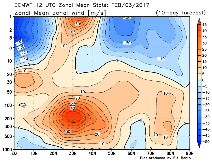
Easterly zonal winds between -5 m/s and -10 m/s are seen at that coordinate which signals a very weak Strat PV susceptible to warm temperatures that arise from wave activity flux. Technically, this is considered a SSWE even though the potent westerly QBO is expected to keep the middle and lower Strat at westerly winds, signaling the PV will not go away rather be highly purturbed / displaced. Nonetheless, this should bring about blocking from the Pacific to the Atlantic, especially the AO region.
EPS valid 30th: Potent trough drops in over the Northeast, but poor western ridge orientation keeps the axis too far east to bring us anything meaningful (check January thread for update on 29th-30th storm). However, have to watch and see if a norlun or inverted trough type features tries to develop.

EPS valid Feb 3rd: People were freaking out a bit yesterday because they saw warm anomalies try to get to the east coast. This is simply a result of the western ridge breaking east but the Northwesterly flow is still advertised to be over our area. In fact, there could be some weak polar energy that tries to bring some snow to the area around this time.
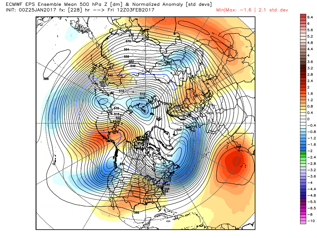
EPS valid Feb 7th:
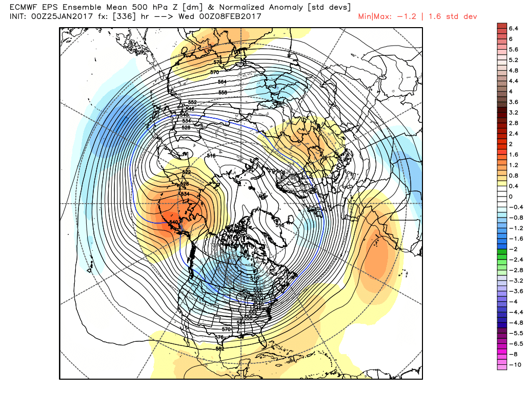
We're looking at coast to coast cold after February 5th or so, with a strong signal for a storm between February 5th and 9th. The trough axis is expected to be more favorable as the Trop PV tracks near the Hudson. The -WPO/-EPO ridging is pinched off and not expected to dissipate anytime soon. There will be frequent round of arctic air entering the CONUS.
What the EPS does not show (yet) but the GEFS does, is the emergence of a -AO/-NAO. Given where the Stratosphere is heading, I feel there will at least be a -AO in our favor.
The GEFS are very cold all the way through February 10th (and beyond).
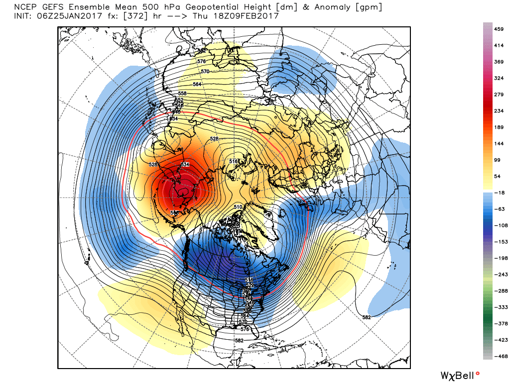
So as I've been saying, be patient and do not expect storm systems to show up on guidance 7-10 days out. The changes our pattern is going through as a result of the tropical forcing and Stratosphere will bring them some mayhem. I trust the first half of February will finish below normal with at least 1 measurable snowfall event.
_________________
_______________________________________________________________________________________________________
CLICK HERE to view NJ Strong Snowstorm Classifications
Frank_Wx- Godzilla Seeker
- Posts : 21305
Reputation : 328
Join date : 2013-01-05
Age : 31
Location : Jersey City, NJ -
Re: Long Range Thread 13.0
![]() by algae888 Wed Jan 25, 2017 9:05 am
by algae888 Wed Jan 25, 2017 9:05 am
Overall, there is good consensus in the global models through
early next week with a full latitude trough digging across
eastern North America this weekend, and a high amplitude ridge
along the west coast. This looks to be a brief change in what has
been a winter dominated by Pacific jet energy. Looking into early
next week though, this pattern returns as the upper trough lifts
out of the east and the ridge out west breaks down. Shorter term
climate signals show no hint of blocking conducive to a cold,
stormy pattern.

algae888- Advanced Forecaster

- Posts : 5311
Reputation : 46
Join date : 2013-02-05
Age : 61
Location : mt. vernon, new york
Re: Long Range Thread 13.0
![]() by Frank_Wx Wed Jan 25, 2017 9:10 am
by Frank_Wx Wed Jan 25, 2017 9:10 am
algae888 wrote:frank nws doesn't share our optimism with upcoming pattern...
Overall, there is good consensus in the global models through
early next week with a full latitude trough digging across
eastern North America this weekend, and a high amplitude ridge
along the west coast. This looks to be a brief change in what has
been a winter dominated by Pacific jet energy. ooking into early
next week though, this pattern returns as the upper trough lifts
out of the east and the ridge out west breaks down. Shorter term
climate signals show no hint of blocking conducive to a cold,
stormy pattern.
Technically, in the short term, there is no blocking or a stormy pattern. Short term (28th to 5th) looks to be normal to below normal but dry.
_________________
_______________________________________________________________________________________________________
CLICK HERE to view NJ Strong Snowstorm Classifications
Frank_Wx- Godzilla Seeker
- Posts : 21305
Reputation : 328
Join date : 2013-01-05
Age : 31
Location : Jersey City, NJ -
Re: Long Range Thread 13.0
![]() by Armando Salvadore Wed Jan 25, 2017 10:21 am
by Armando Salvadore Wed Jan 25, 2017 10:21 am

Armando Salvadore- Advanced Forecaster
- Posts : 171
Reputation : 0
Join date : 2016-12-23
Location : Springfield, NJ
Re: Long Range Thread 13.0
![]() by Frank_Wx Wed Jan 25, 2017 10:54 am
by Frank_Wx Wed Jan 25, 2017 10:54 am
Armando Salvadore wrote:Great stuff Frank, some discrepancy between the GFS and ECMWF regarding the stratospheric warming as the EURO is more robust with the descent 0-wind line. The consensus is, it'll become very vulnerable to continued wave driving, and if we do see an emergence of another MJO event, one would think we see a huge attack. Regardless, it's looking good for the LR i believe and that period around the 6th has my attention. Also still not letting the 30th slip passed, think we may have to just watch that.
Unfortunately a SSWE (a full ranged one from top to lower Strat) that takes places in mid-February will not bring meaningful impacts to our Meteorological winter pattern since there is a lag time. So while this Wave 1 warming even should bring positive changes to our 500mb, it's likely not sustainable. The best SSWE are those that occur in January.
_________________
_______________________________________________________________________________________________________
CLICK HERE to view NJ Strong Snowstorm Classifications
Frank_Wx- Godzilla Seeker
- Posts : 21305
Reputation : 328
Join date : 2013-01-05
Age : 31
Location : Jersey City, NJ -
Page 1 of 40 • 1, 2, 3 ... 20 ... 40 ![]()
|
|
|