
 Search
My Winter Outlook 2016-17

My Winter Outlook 2016-17
![]() by Isotherm Sat Nov 12, 2016 5:33 pm
by Isotherm Sat Nov 12, 2016 5:33 pm
Overview of Preset Conditions
The atmospheric/oceanic state in which we find ourselves right now is multifactorial. The super El Nino event last winter aided in inducing a variety of atmospheric tendencies: surged global temperatures such that the ensuing year features an inordinate amount of residual northern hemispheric heat, largely as a function of the excessive latent heat release via prior tropical forcing; the additional, significant injection of westerly atmospheric angular momentum (corresponding to the excessive forcing) precluded the descent of easterly stratospheric winds, thus resetting the QBO into a condition of predominately high westerly shear stress. The enormous latitudinal thermal gradient induced largely by super Nino conditions drove the stratospheric vortex into an insurmountably potent state; however, upon its collapse last spring, the vortex has remained unprecedentedly weak. One may hypothesize that this implicates a repressed vortex status for the ensuing winter, but exogenous indicators suggest otherwise. The ENSO condition is cold-neutral bordering on weak La Nina, which will likely persist for the duration of the winter. SST’s and tropical forcing are reflective of a classic Nina-esque walker cell orientation. It will be important to ascertain the likely modalities and proclivities of high latitude indices, in light of the lesser ENSO forcing (though this isn’t entirely the case). The anticipated behavior of the various global oscillations and their concomitant z500 results will form the basis of this outlook.
Examination of Integral Factors
ENSO status is cold-neutral to weak La Nina. The vast majority of model guidance maintains the cold-neutral/weak La Nina regime throughout the winter. Whether the resultant situation is weak Nina or cold-neutral, the z500 and sensible weather outcome disparities would be immaterial.
The oceanic-atmospheric coupling has been relatively weak thus far. SOI daily values have been near neutral or even negative at times – in concert with a strongly heightened angular momentum state – the resultant regime has more closely projected on the climatological El Nino z500 pattern rather than La Nina (at least in the Pacific). The extended Pacific jet is a consequence, with a flood of warm, maritime air into Canada. This regime will experience significant alterations over the coming weeks. The atmospheric coupling response will manifest more robustly as Indonesian/Maritime tropical forcing and rapidly decreasing angular momentum (that is, a removal of atmospheric momentum from the energy budget), will eventually cause the Pacific jet to retract. The more classic low-mid latitude Aleutian ridging and concomitant troughing in the eastern Gulf of Alaska and Western US will develop by late November. The momentum will decrease to such an extent that lower than normal geopotential heights will dominate the northeast Pacific. Inter-seasonal low frequency tropical forcing should congregate in the W Pacific/Indonesian region thus winter – principally within the “domain space” of MJO phases 4-5-6. Large scale subsidence should dominate the dateline and Western Indian Ocean regions, with potentially a secondary, less potent upper divergence area near northern South America. So far this autumn, the dateline eastward in the Pacific – both tropically and sub-tropically – has been largely devoid of 200hpa negative velocity potential, while the inverse has been true to the west of the dateline. All of the aforementioned has implications insofar as Rossby wave driving and mid latitude responses.
Tropospheric boundary layer conditions thus autumn have been suggestive of a highly perturbed vortex and would – in a vacuum – portend a weak winter stratospheric (and consequently tropospheric) vortex. Both snow cover extent and advance has been quite impressive when juxtaposed with the majority of seasons over the previous 30 years. The resultant Siberian high development and concomitant Taymyr geopotential height anomalies have been robust; namely, higher than normal geopotential heights have generally persisted in that region. The development of certain tropospheric patterns is crucial as often times they will project strongly onto climatological wave 1 and wave 2. The significance of this is that a tropospheric pattern which constructively interferes with vertical wave driving will converge and perturb the vortex.
As noted prior, the westerly shear stress has persisted in the stratosphere. The westerly QBO strengthened (became more positive over the past couple months. The ensuing winter state will be strongly positive, becoming more moderate late, and likely reversing into the negative state (finally) by spring 2017. Solar conditions have been variable but largely depressed. 10.7cm solar flux values are very low; generally under 800. This will continue or decrease during the winter. Solar minimum with respect to cycle 25 will occur between 2018-2020. Geomagnetic activity (proxy: AP index) min-max cycles are typically lagging that of flux and sunspot numbers. Geomagnetic parameters suggested a decline this summer, but it has been rather active again this autumn.
Precursor sea surface temperatures in the Atlantic Ocean were analyzed for specific trends/anomalies which could be relevant insofar as NAO modality trends.
Research has demonstrated that there might be a tendency for the development of poleward Aleutian mid-level ridges under a cold ENSO/+QBO regime. The correlation is a strong one. However, I have noted disparities in the recent autumn/current pattern, in terms of atmospheric behavior and forcing which do not project onto the +QBO/-ENSO z500 result. This casts doubt on the notion for a persistent poleward ridge in the Pacific.
The PDO has been in a predominately positive phase, though declining over recent weeks. The Gulf of Alaska has cooled dramatically due to the extended jet and low geopotential height anomalies. However, the forcing emanating from this region is immaterial, and provides positive feedback at maximum in terms of the ensuing pattern. A more interesting propensity has been the latitudinal sea surface temperature gradient with very warm waters running horizontally across the sub-tropical Pacific and cold waters immediately to the north. This will add momentum to the Pacific jet and aid in precluding, at least in a protracted fashion, significant poleward blockiness. However, the westerly shear stress via the QBO and its connection to forcing modulation may result in a period of such poleward blockiness.
The AMO has been mostly positive with the western Atlantic warmer than normal. The feedback generated from this will be insignificant compared to the Pacific, but it could aid in intensifying extra-tropical cyclones near the East Coast. Additional available energy increases the likelihood for a reversal in the predominate precipitation pattern from dry to wet across portions of the Northeastern US.
The sum of methodologies has included analysis of exogenous indicators such as solar, geomagnetic trends/behavior, stratospheric winds, and internal variability of the PDO, AMO, ENSO, tropical forcing, NAO, AO, EPO, PNA (including a relationship I’ve examined which – retrospectively - correctly predicted the NAO modality in 86% of seasons since 1950); prior years have been juxtaposed with the present/recent pattern in attempt to ascertain an extrapolation of this year’s regime. The totality of indicators yields the following prognostication.
Indicator Outlook for DJF mean:
PDO: Near neutral to slightly positive
AMO: Positive
EPO: Positive average; transient periods of negative
NAO: Positive (potentially strongly at times); one month of negative is possible
AO: Near-neutral; favoring early winter for the negative periods, becoming more positive
ENSO: Cold neutral to weak La Nina
PNA: Near neutral; periods of both positive and negative
AAM: Predominately negative/easterly
QBO: Strongly becoming moderately positive/westerly
Anticipated Progression:
In examination of prior years, there were innumerable disparities which made it exceedingly difficult to select analog years. However, the totality of indicators studied yielded the following for closest years:
Primary analog: 1973-74
Secondary analog: 1975-76
Tertiary analog: 1999-2000
There were some notable similarities to 2011-12 as well, though insufficient to utilize it as a higher echelon analog. One will note that all three of the analog years were actually moderate to strong La Nina’s, which differs from the current ENSO state. However, there were numerous other (arguably more important in my view) strongly similar variables. I anticipate a suppressed AAM state, a strengthening polar vortex, La Nina-esque walker and Hadley cell behavior, tropical forcing, which more closely reflects the –QBO/-ENSO years rather than the +QBO/-ENSO years.
December should begin with a neutral to negative tropospheric and stratospheric AO due to the exceptional tropo-stratospheric perturbation. The Pacific will largely be unfavorable with a positive EPO and low geopotential heights amplifying in the Rockies/W US, indicative of a –AAM regime. The NAO could potentially trend negative for a time, combatting the poor Pacific, enabling some troughiness to develop in the C/E US. Many of the analog years featured one month of colder than normal temperatures with more conducive z500 regime. 1975-76 featured a very cold January, and 1973-74 a colder than normal February, and 1999-2000 a colder than normal January. However, there are a number of adjustments that should be performed. There is significantly greater global/hemispheric warmth compared to the 1970s analogs due to the post super Nino conditions. Secondly, the state of the stratospheric vortex is very weak right now, and projected to remain that way through November. There’s a high correlation between November and December outcomes. Thus, I think December is the month most likely to feature high latitude blocking. However, it must be sufficiently significant, especially in the NAO domain to mute +EPO induced Western troughiness. The Southeast ridge will be attempting to burgeon northward. Thus, even early winter, I am conflicted, but given signaling and analogs, December should be near normal temperature wise in the Northeast corridor, with possibly slightly above or slightly below temps. Given the precursor factors and analogs, I expect the precipitation pattern to become increasingly wet across the northern tier and Northeast. I don’t believe it will be sufficient to reverse the drought in the Northeast, but a normal or wetter than normal winter is likely with a warm W Atlantic an active Pacific stream.
January will become increasingly warm with a rapidly intensifying vortex. In the Pacific, the continuance of a low-latitude Aleutian ridge with low heights across Alaska/NE Pacific and NW US should persist. However, periods of poleward Aleutian ridging are possible, occasionally suppressing the Eastern ridge and providing wintry threats. The vast majority of the time, the Atlantic should be unfavorable. Transient blocks are not out of the question. January should be warmer than normal for most of the South and East, with colder weather confined to the Rockies and northern tier.
February should look like a classic Nina-esque regime at z500 and likely in the low levels. An active jet with numerous snow threats across the Mid-west and northern New England should dominate. A continued unfavorable Atlantic and increasingly unfavorable Arctic, coupled with an indeterminate NPAC state could yield occasionally mild to record warm temperatures in the Eastern US. Snowfall will be highly dependent upon transient blocks and baroclinic zone suppression via poleward NPAC ridging. Overall, the month looks warmer than January. Cold weather dominates the N Plains.
In sum, this winter will be colder than last year (not surprising given the record warmth), but warmer than normal across the South and most of the East. Colder than normal departures will be found across the NW US/Rockies and into the Mid-west. The most likely period for a severely cold outbreak, including the East is between December 20th-January 15th. If a coupling can occur between high latitude blocking and poleward Pacific ridging, the wintertime source region of cold can expand southeastward. All three analogs featured a period of colder than normal weather in the East. For the most part, the East Coast will be battling milder weather. Precip should be normal to above from the Mid-Atlantic northward, and snowfall normal to below from the Mid-Atlantic southward. There should be more frequent light-mod snows across the North with fewer large events. Bigger events are possible in the Lakes/Interior Northeast with intensifying inland lows.
Outlook Temperatures:
For the Local New York City Region:
Dec-Jan-Feb Temperature Departure Outlook: +1 to +2; Warmer than normal
[Expected evolution is near normal December, warmer than normal January, and warmer than normal February].
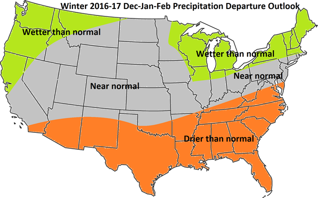
Dec-Jan-Feb Precipitation Departure Outlook: Near normal (possibly above to the north)
Nov-Mar Snowfall Departure Outlook: Near normal to the north of NYC and below normal from NYC southward
Snowfall guesses for various CONUS locations:
Burlington, VT: 90-100”
Boston: 40-45”
New York City: 21-26”
Philadelphia: 13-18”
Baltimore: 10-15”
Washington DC: 9-14”
Richmond, VA: 5-10”
Raleigh, NC: 0-5”
Atlanta, GA: <2”
Houston, TX: <1”
Chicago, IL: 45-50”
Denver, CO: 60-65”
Seattle, WA: 5-10”
Analogs:
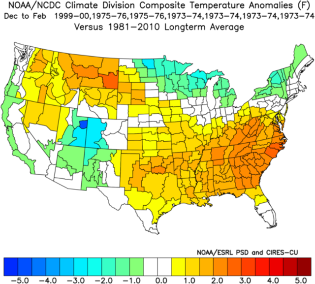
Primary analog z500:


Isotherm- Advanced Forecaster

- Posts : 231
Reputation : 4
Join date : 2014-09-01
Age : 33
Location : Monmouth County, NJ -

Re: My Winter Outlook 2016-17
![]() by Dunnzoo Sat Nov 12, 2016 7:50 pm
by Dunnzoo Sat Nov 12, 2016 7:50 pm
_________________
Janet
Snowfall winter of 2023-2024 17.5"
Snowfall winter of 2022-2023 6.0"
Snowfall winter of 2021-2022 17.6" 1" sleet 2/25/22
Snowfall winter of 2020-2021 51.1"
Snowfall winter of 2019-2020 8.5"
Snowfall winter of 2018-2019 25.1"
Snowfall winter of 2017-2018 51.9"
Snowfall winter of 2016-2017 45.6"
Snowfall winter of 2015-2016 29.5"
Snowfall winter of 2014-2015 50.55"
Snowfall winter of 2013-2014 66.5"

Dunnzoo- Senior Enthusiast - Mod

- Posts : 4885
Reputation : 68
Join date : 2013-01-11
Age : 62
Location : Westwood, NJ
Re: My Winter Outlook 2016-17
![]() by amugs Sun Nov 13, 2016 8:26 am
by amugs Sun Nov 13, 2016 8:26 am
The weenie in me doesn't like your forecast but I duly respect your weather intelligence.
_________________
Mugs
AKA:King: Snow Weenie
Self Proclaimed
WINTER 2014-15 : 55.12" +.02 for 6 coatings (avg. 35")
WINTER 2015-16 Total - 29.8" (Avg 35")
WINTER 2016-17 : 39.5" so far

amugs- Advanced Forecaster - Mod
- Posts : 15093
Reputation : 213
Join date : 2013-01-07
Age : 54
Location : Hillsdale,NJ
Re: My Winter Outlook 2016-17
![]() by algae888 Sun Nov 13, 2016 12:36 pm
by algae888 Sun Nov 13, 2016 12:36 pm

algae888- Advanced Forecaster
- Posts : 5311
Reputation : 46
Join date : 2013-02-05
Age : 61
Location : mt. vernon, new york
Re: My Winter Outlook 2016-17
![]() by frank 638 Sun Nov 13, 2016 1:29 pm
by frank 638 Sun Nov 13, 2016 1:29 pm
frank 638- Senior Enthusiast

- Posts : 2824
Reputation : 37
Join date : 2016-01-01
Age : 40
Location : bronx ny
Re: My Winter Outlook 2016-17
![]() by Frank_Wx Sun Nov 13, 2016 2:27 pm
by Frank_Wx Sun Nov 13, 2016 2:27 pm
_________________
_______________________________________________________________________________________________________
CLICK HERE to view NJ Strong Snowstorm Classifications

Frank_Wx- Godzilla Seeker

- Posts : 21305
Reputation : 328
Join date : 2013-01-05
Age : 31
Location : Jersey City, NJ -
Re: My Winter Outlook 2016-17
![]() by Guest Sun Nov 13, 2016 9:05 pm
by Guest Sun Nov 13, 2016 9:05 pm
It's confusing for many while reading the various winter outlooks when last year was an El Niño year and we were above normal temps and this year looks to be a La Niña year with above normal temps, even with a lot of snow over way up north.
Guest- Guest
Re: My Winter Outlook 2016-17
![]() by Frank_Wx Sun Nov 13, 2016 10:30 pm
by Frank_Wx Sun Nov 13, 2016 10:30 pm
Very well written. Good luck!
_________________
_______________________________________________________________________________________________________
CLICK HERE to view NJ Strong Snowstorm Classifications
Frank_Wx- Godzilla Seeker
- Posts : 21305
Reputation : 328
Join date : 2013-01-05
Age : 31
Location : Jersey City, NJ -
Re: My Winter Outlook 2016-17
![]() by Isotherm Mon Nov 14, 2016 8:58 pm
by Isotherm Mon Nov 14, 2016 8:58 pm
Yeah I'm a bit warmer as I feel strongly about an unfavorable mean NAO and the Pacific not being all that great either. The AO may be a better friend this year, though I think more positive will win out later. Should be no +15 months to worry about though (hopefully)!
Isotherm- Advanced Forecaster
- Posts : 231
Reputation : 4
Join date : 2014-09-01
Age : 33
Location : Monmouth County, NJ -
Re: My Winter Outlook 2016-17
![]() by Isotherm Sun Mar 19, 2017 4:42 pm
by Isotherm Sun Mar 19, 2017 4:42 pm
http://www.lightinthestorm.com/archives/1026
Text:
Central Park DJF temperature departure: +4.1
Most of the tri-state area finished between +3.5 and +4.2 for temperature departures.
Snowfall: 30.2″
Snowfall Forecast versus actual totals:
Burlington, VT: 90-100” 91”
Red Sox Suck: 40-45” 45.8”
New York City: 21-26” 30.2”
Philadelphia: 13-18” 15”
Baltimore: 10-15” 2.9”
Washington DC: 9-14” 3.4”
Richmond, VA: 5-10” 7.1”
Raleigh, NC: 0-5” 0.8”
Atlanta, GA: <2” T Houston, TX: <1” 0 Chicago, IL: 45-50” 26.1” Denver, CO: 60-65” 19.3” Seattle, WA: 5-10” 11.2”
VERIFICATION DISCUSSION:
Based upon the forecast maps from late November, the z500 pattern quite closely paralleled the outlook expectations. Troughiness preferentially favored the NW United States while concurrently, ridging predominated the Eastern US. Occasional poleward ridging near Alaska/Dateline permitted periodic cold blasts into the United States, but for the most part, the Pacific remained unfavorable. Additionally, the NAO was strongly positive as anticipated, with a largely inauspicious AO regime as well (both were positive).
In terms of the sensible weather, December verified as the coldest month of the winter with slightly warmer than normal temperatures in the East as forecasted, with January and February featuring well above normal temperatures.
Dryness dominated the South and East while a wetter than normal preferentially favored the West and northern tier.
Snowfall was very close to reality, with below to well below normal snowfall from 40N southward, and near or above normal snowfall from NYC northward. The slight flaw here was that the above normal snowfall extended a bit further south than expected into portions of the NYC area/Long Island. Furthermore, DCA/BWI area featured even less snowfall than forecast, and Denver into portions of the Mid-west (Chicago) received very little snow relative to normal. Seattle’s totals were close to forecasted, as were totals in the Southeast US and New England.
Overall, considering the lead time of the long range forecast and the nature of the record warmth in January and February, the outlook for solidly warmer than normal temperature departures across the vast majority of the United States worked very well in my opinion. Hindsight is 20/20, and certainly I would have gone even warmer, but given some conflicting signals (a few suggestive of cold) last autumn, the magnitude of the forecasted warmth was slightly tempered. Even still, the general ideas and progression verified, and this winter forecast will be considered a success. This will bring the long range success rate up to 80% since initiation of long range summer/winter outlooks in 2006.
Overall Winter 2016-17 Grade: A-
Isotherm- Advanced Forecaster
- Posts : 231
Reputation : 4
Join date : 2014-09-01
Age : 33
Location : Monmouth County, NJ -
Re: My Winter Outlook 2016-17
![]() by CPcantmeasuresnow Sun Mar 19, 2017 5:29 pm
by CPcantmeasuresnow Sun Mar 19, 2017 5:29 pm
Isotherm wrote:VERIFICATION - can be read here with associated maps:
http://www.lightinthestorm.com/archives/1026
Text:
Central Park DJF temperature departure: +4.1
Most of the tri-state area finished between +3.5 and +4.2 for temperature departures.
Snowfall: 30.2″
Snowfall Forecast versus actual totals:
Burlington, VT: 90-100” 91”
Red Sox Suck: 40-45” 45.8”
New York City: 21-26” 30.2”
Philadelphia: 13-18” 15”
Baltimore: 10-15” 2.9”
Washington DC: 9-14” 3.4”
Richmond, VA: 5-10” 7.1”
Raleigh, NC: 0-5” 0.8”
Atlanta, GA: <2” T Houston, TX: <1” 0 Chicago, IL: 45-50” 26.1” Denver, CO: 60-65” 19.3” Seattle, WA: 5-10” 11.2”
VERIFICATION DISCUSSION:
Based upon the forecast maps from late November, the z500 pattern quite closely paralleled the outlook expectations. Troughiness preferentially favored the NW United States while concurrently, ridging predominated the Eastern US. Occasional poleward ridging near Alaska/Dateline permitted periodic cold blasts into the United States, but for the most part, the Pacific remained unfavorable. Additionally, the NAO was strongly positive as anticipated, with a largely inauspicious AO regime as well (both were positive).
In terms of the sensible weather, December verified as the coldest month of the winter with slightly warmer than normal temperatures in the East as forecasted, with January and February featuring well above normal temperatures.
Dryness dominated the South and East while a wetter than normal preferentially favored the West and northern tier.
Snowfall was very close to reality, with below to well below normal snowfall from 40N southward, and near or above normal snowfall from NYC northward. The slight flaw here was that the above normal snowfall extended a bit further south than expected into portions of the NYC area/Long Island. Furthermore, DCA/BWI area featured even less snowfall than forecast, and Denver into portions of the Mid-west (Chicago) received very little snow relative to normal. Seattle’s totals were close to forecasted, as were totals in the Southeast US and New England.
Overall, considering the lead time of the long range forecast and the nature of the record warmth in January and February, the outlook for solidly warmer than normal temperature departures across the vast majority of the United States worked very well in my opinion. Hindsight is 20/20, and certainly I would have gone even warmer, but given some conflicting signals (a few suggestive of cold) last autumn, the magnitude of the forecasted warmth was slightly tempered. Even still, the general ideas and progression verified, and this winter forecast will be considered a success. This will bring the long range success rate up to 80% since initiation of long range summer/winter outlooks in 2006.
Overall Winter 2016-17 Grade: A-
Tom:
Phenomenal job. It's an A if ever there was one.
CP

CPcantmeasuresnow- Wx Statistician Guru

- Posts : 7274
Reputation : 230
Join date : 2013-01-07
Age : 103
Location : Eastern Orange County, NY
Re: My Winter Outlook 2016-17
![]() by rb924119 Sun Mar 19, 2017 5:45 pm
by rb924119 Sun Mar 19, 2017 5:45 pm
rb924119- Meteorologist

- Posts : 6889
Reputation : 194
Join date : 2013-02-06
Age : 32
Location : Greentown, Pa
Re: My Winter Outlook 2016-17
![]() by frank 638 Sun Mar 19, 2017 7:24 pm
by frank 638 Sun Mar 19, 2017 7:24 pm
frank 638- Senior Enthusiast
- Posts : 2824
Reputation : 37
Join date : 2016-01-01
Age : 40
Location : bronx ny
Re: My Winter Outlook 2016-17
![]() by Dunnzoo Mon Mar 20, 2017 8:00 am
by Dunnzoo Mon Mar 20, 2017 8:00 am
_________________
Janet
Snowfall winter of 2023-2024 17.5"
Snowfall winter of 2022-2023 6.0"
Snowfall winter of 2021-2022 17.6" 1" sleet 2/25/22
Snowfall winter of 2020-2021 51.1"
Snowfall winter of 2019-2020 8.5"
Snowfall winter of 2018-2019 25.1"
Snowfall winter of 2017-2018 51.9"
Snowfall winter of 2016-2017 45.6"
Snowfall winter of 2015-2016 29.5"
Snowfall winter of 2014-2015 50.55"
Snowfall winter of 2013-2014 66.5"
Dunnzoo- Senior Enthusiast - Mod
- Posts : 4885
Reputation : 68
Join date : 2013-01-11
Age : 62
Location : Westwood, NJ
Re: My Winter Outlook 2016-17
![]() by Isotherm Mon Mar 20, 2017 7:58 pm
by Isotherm Mon Mar 20, 2017 7:58 pm
Isotherm- Advanced Forecaster
- Posts : 231
Reputation : 4
Join date : 2014-09-01
Age : 33
Location : Monmouth County, NJ -
Re: My Winter Outlook 2016-17
![]() by hyde345 Mon Mar 20, 2017 8:39 pm
by hyde345 Mon Mar 20, 2017 8:39 pm

hyde345- Pro Enthusiast

- Posts : 1082
Reputation : 48
Join date : 2013-01-08
Location : Hyde Park, NY
Re: My Winter Outlook 2016-17
![]() by docstox12 Tue Mar 21, 2017 6:16 am
by docstox12 Tue Mar 21, 2017 6:16 am

docstox12- Wx Statistician Guru
- Posts : 8502
Reputation : 222
Join date : 2013-01-07
Age : 73
Location : Monroe NY
Re: My Winter Outlook 2016-17
![]() by nutleyblizzard Tue Mar 21, 2017 6:27 am
by nutleyblizzard Tue Mar 21, 2017 6:27 am

nutleyblizzard- Senior Enthusiast
- Posts : 1952
Reputation : 41
Join date : 2014-01-30
Age : 58
Location : Nutley, new jersey
Re: My Winter Outlook 2016-17
![]() by Frank_Wx Tue Mar 21, 2017 10:37 am
by Frank_Wx Tue Mar 21, 2017 10:37 am
_________________
_______________________________________________________________________________________________________
CLICK HERE to view NJ Strong Snowstorm Classifications
Frank_Wx- Godzilla Seeker
- Posts : 21305
Reputation : 328
Join date : 2013-01-05
Age : 31
Location : Jersey City, NJ -
Re: My Winter Outlook 2016-17
![]() by Isotherm Tue Mar 21, 2017 9:27 pm
by Isotherm Tue Mar 21, 2017 9:27 pm
Isotherm- Advanced Forecaster
- Posts : 231
Reputation : 4
Join date : 2014-09-01
Age : 33
Location : Monmouth County, NJ -
Re: My Winter Outlook 2016-17
![]() by sroc4 Wed Mar 22, 2017 10:17 am
by sroc4 Wed Mar 22, 2017 10:17 am
Despite a dismal season temperature wise filled with sustained warmth and a lack thereof for sustained cold I ended with just over 42" total snowfall for the season; well above normal IMBY. For me this is like watching a hockey game. For the entire game the other team dominated the time of possession, out shot us 42 to 20, and dominated the physical play; however; our goalie stood on his head to keep us in the game. When we had our opportunities we were able to score enough goals to win the game...at least in my neck of the woods. Just like in any sport if you can still win the game despite not playing your best you will take the win every time; then move on to the next one.
I never give a grade to winter before the end of March because we have had too many decent Marches in recent pasts to not include it when rating a winter season. In my rating system I will always weight total snowfall, number of snow events, and the quality of a snow event much higher than the temp aspect of a season. With this in mind, if I get no more snow this season I would have to rate this winter a C+ based on the volume of snow events as well as the fact that there was at least one Godzilla IMBY, as well as a few decent mod events. If we had any sort of sustained cold I would have definitely rated this winter a B.
_________________
"In weather and in life, there's no winning and losing; there's only winning and learning."
WINTER 2012/2013 TOTALS 43.65"WINTER 2017/2018 TOTALS 62.85" WINTER 2022/2023 TOTALS 4.9"
WINTER 2013/2014 TOTALS 64.85"WINTER 2018/2019 TOTALS 14.25" WINTER 2023/2024 TOTALS 13.1"
WINTER 2014/2015 TOTALS 71.20"WINTER 2019/2020 TOTALS 6.35"
WINTER 2015/2016 TOTALS 35.00"WINTER 2020/2021 TOTALS 37.75"
WINTER 2016/2017 TOTALS 42.25"WINTER 2021/2022 TOTALS 31.65"

sroc4- Admin
- Posts : 8331
Reputation : 301
Join date : 2013-01-07
Location : Wading River, LI
Re: My Winter Outlook 2016-17
![]() by Isotherm Fri Mar 24, 2017 4:42 pm
by Isotherm Fri Mar 24, 2017 4:42 pm
Yeah, this winter snowfall wasn't bad given the hand we had dealt to us - very poor precursor indicators. I am surprised and not surprised that NYC broke 30". The pattern was largely unfavorable, but lately it has been more risky to bet against a near or above average snowfall winter in our area. The 1990-2020 averages will be significantly higher assuming the next few winters aren't duds.
Isotherm- Advanced Forecaster
- Posts : 231
Reputation : 4
Join date : 2014-09-01
Age : 33
Location : Monmouth County, NJ -
Re: My Winter Outlook 2016-17
![]() by CPcantmeasuresnow Fri Mar 24, 2017 11:37 pm
by CPcantmeasuresnow Fri Mar 24, 2017 11:37 pm
Isotherm wrote:Thanks for the nice compliment Scott, appreciate it. Looking forward to many more LR discussions qith you and everyone else on here. You agreed with the late winter alterations and definitely provide great value to this site as well. And yes, I do enjoy tropical disturbances as well - hopefully this year is more interesting. I typically do a summer forecast every May, but maybe I will incorporate a tropical section too this year.
Yeah, this winter snowfall wasn't bad given the hand we had dealt to us - very poor precursor indicators. I am surprised and not surprised that NYC broke 30". The pattern was largely unfavorable, but lately it has been more risky to bet against a near or above average snowfall winter in our area. The 1990-2020 averages will be significantly higher assuming the next few winters aren't duds.
Tom:
The 1980's were the worst decade for snow in these parts in recorded history so when they are taken out of the equation in 3 years the 1991-2020 average in NYC will go up from the current 1981-2010 average of 25.8. Even if it doesn't snow for the next 3 years (its never happened in a single season so God forbid, I shudder at the thought) the 30 year average for NYC for 1991-2020 would be 27.4 inches.
The current running 30 year average in NYC is 29.0 inches
The current average for January 1991-March 2017 is 30.6 inches
The current average for January 2002-March 2017 is 34.6 inches.
Throw away all the averages in 3 years because in our area they're all going up, despite the rise in average temperatures which has been quite pronounced. Eventually I suppose the dichotomy of increasing temperatures and increasing snowfall will reach a breaking point, unless of course this upward trend in temperatures we've experienced since the early 1980's or thereabouts begins to reverse, or at the least stops increasing.
CPcantmeasuresnow- Wx Statistician Guru
- Posts : 7274
Reputation : 230
Join date : 2013-01-07
Age : 103
Location : Eastern Orange County, NY
Re: My Winter Outlook 2016-17
![]() by Isotherm Tue Mar 28, 2017 4:41 pm
by Isotherm Tue Mar 28, 2017 4:41 pm
My 30 year running average is up to 31.2" here, with the 1980-2010 avg of 28.9". I will definitely be above 30" it appears for the next 1990-2020 30 year period. I have always maintained that our area (CNJ-NYC) is upper 20s or around 30 in terms of averages. We may keep increasing if the a priori effects of the protracted solar minimum impact blocking.
Isotherm- Advanced Forecaster
- Posts : 231
Reputation : 4
Join date : 2014-09-01
Age : 33
Location : Monmouth County, NJ -
|
|
|