
 Search
2017-18 Winter Discussion thread
Page 5 of 6 •  1, 2, 3, 4, 5, 6
 ![]()
Re: 2017-18 Winter Discussion thread
![]() by docstox12 Fri Oct 20, 2017 5:21 am
by docstox12 Fri Oct 20, 2017 5:21 am
amugs wrote:Here is an interesting graph from a met on another board computation of La Nina and NAO mean average and Snowfall amounts
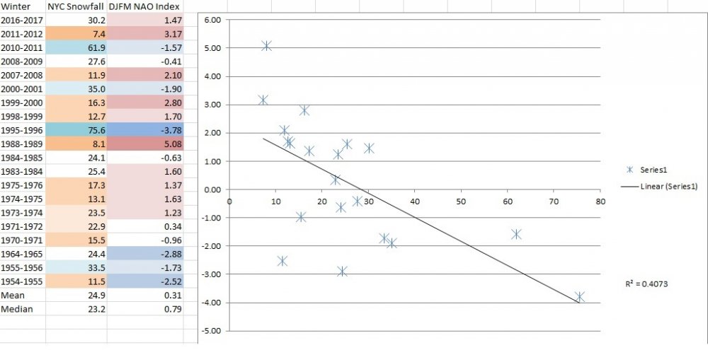
Mugsy, the only thing I get out of that is the two extremes, '95-96 and '88-'89.Everything else is all over the place.Of course, that's in my opinion FWIW.
Seeing winter forecasts of warmer than normal with normal or a little above average snowfall.Don't mind it milder as long as there is normal or above normal snow.It would probably favor me up here in the HV with the elevation.As Doc says, "you gotta smell the rian to get the heavy snow". Can't even think of winter with this ridiculous October warm spell going on.
docstox12- Wx Statistician Guru

- Posts : 8497
Join date : 2013-01-07
Re: 2017-18 Winter Discussion thread
![]() by Math23x7 Sun Oct 22, 2017 10:53 pm
by Math23x7 Sun Oct 22, 2017 10:53 pm
Math23x7- Wx Statistician Guru
- Posts : 2379
Join date : 2013-01-08
Re: 2017-18 Winter Discussion thread
![]() by algae888 Mon Oct 23, 2017 3:35 am
by algae888 Mon Oct 23, 2017 3:35 am
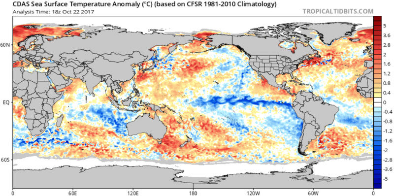
Yes Mike but on the flip side look at the warm Waters near Greenland. The last few years they were cold they are warm now and continuing to warm. We also have very warm Waters off the New England coast which is not good. Hopefully we can get a system or two to come in and up well some of the water and cool that down and keep the water warm south of Greenland. Then instead of having positive feedback near the New England coast we will get it near greenland which should help with a negative Nao. we shall see. euro has a 994 low off the Carolina coast day 7. Maybe that can turn the waters up a little start cooling them down east of New EnglandMath23x7 wrote:Honestly, given the cooler waters over the Pacific, including off of southern Alaska and off the west coast, I don’t think we will get the assistance of the red blob like we did in 2013-14 and 2014-15. I think the only way we can get the cold/snowy winter we want is with the super negative AO/NAO with a bit of ridging out west. The 1995-96 winter and the first half of the 2010-11 winter saw just that. Without it, it will be a struggle to get the snow here.

algae888- Advanced Forecaster

- Posts : 5311
Reputation : 46
Join date : 2013-02-05
Age : 61
Location : mt. vernon, new york
Re: 2017-18 Winter Discussion thread
![]() by Math23x7 Mon Oct 23, 2017 3:37 am
by Math23x7 Mon Oct 23, 2017 3:37 am
algae888 wrote:Yes Mike but on the flip side look at the warm Waters near Greenland. The last few years they were cold they are warm now and continuing to warm. We also have very warm Waters off the New England coast which is not good. Hopefully we can get a system or two to come in and up well some of the water and cool that down and keep the water warm south of Greenland. Then instead of having positive feedback near the New England coast we will get it in the agreement which should help promote and negative Nao we shall see euro has a 994 low off the Carolina coast day 7. Maybe that can turn the water is up a little start cooling him down east of New EnglandMath23x7 wrote:Honestly, given the cooler waters over the Pacific, including off of southern Alaska and off the west coast, I don’t think we will get the assistance of the red blob like we did in 2013-14 and 2014-15. I think the only way we can get the cold/snowy winter we want is with the super negative AO/NAO with a bit of ridging out west. The 1995-96 winter and the first half of the 2010-11 winter saw just that. Without it, it will be a struggle to get the snow here.
That is basically what I was saying. We need the ridging near Greenland (aka the Greenland block) for any chance of a cold/snowy winter in these parts.
Math23x7- Wx Statistician Guru
- Posts : 2379
Reputation : 68
Join date : 2013-01-08
Re: 2017-18 Winter Discussion thread
![]() by amugs Mon Oct 23, 2017 2:14 pm
by amugs Mon Oct 23, 2017 2:14 pm

_________________
Mugs
AKA:King: Snow Weenie
Self Proclaimed
WINTER 2014-15 : 55.12" +.02 for 6 coatings (avg. 35")
WINTER 2015-16 Total - 29.8" (Avg 35")
WINTER 2016-17 : 39.5" so far

amugs- Advanced Forecaster - Mod

- Posts : 15091
Reputation : 213
Join date : 2013-01-07
Age : 54
Location : Hillsdale,NJ
Re: 2017-18 Winter Discussion thread
![]() by algae888 Mon Oct 23, 2017 5:02 pm
by algae888 Mon Oct 23, 2017 5:02 pm
Yes mugs and I love that little blue in northwest New Jersey in northeast PAamugs wrote:Snowpack I speak of up North - build that glacier and it shall help us down the road
algae888- Advanced Forecaster
- Posts : 5311
Reputation : 46
Join date : 2013-02-05
Age : 61
Location : mt. vernon, new york
Re: 2017-18 Winter Discussion thread
![]() by algae888 Thu Oct 26, 2017 4:17 pm
by algae888 Thu Oct 26, 2017 4:17 pm


can anyone explains the sig. of that cold pool in the indian ocean.if I am not mistaken indian ocean has been warm the last few years. is it favorable or not for our winter. tks.

algae888- Advanced Forecaster
- Posts : 5311
Reputation : 46
Join date : 2013-02-05
Age : 61
Location : mt. vernon, new york
Re: 2017-18 Winter Discussion thread
![]() by sroc4 Fri Oct 27, 2017 7:52 am
by sroc4 Fri Oct 27, 2017 7:52 am
sroc4 wrote:
by sroc4 on Wed Oct 18, 2017 6:42 am
With a recurving Typhoon over the next 5-7days a decent shot of cold is coming into the east. It should only last about 5-7days overall beginning around the 24th-25th and lasting through about the 31st with a brief moderation in the middle of that time.
Beyond that we will have to see. Some hints at a piece of the mean trough near the Aleutians will break off and dropping south towards the west coast which would bring us back to higher heights overall in the east (La Nina like base state). As of now that is our main driver(neutral to La Nina like pattern, "base state"= when other pattern enhancers are not at play, but the MJO is strongly pulsing and forecasted to propagate strongly through phases 5-7 before possibly crashing back into the COD. We will see how the MJO forecasts play out as well as the MJO wave is def something that will affect the big picture in likely a transient way if it goes back into the COD.
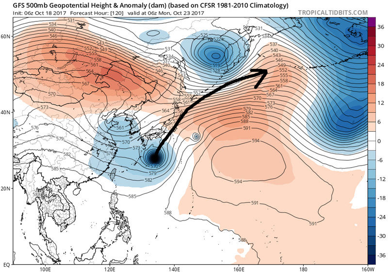
Ok so lets start back on Oct 18th. Look at the quote above at the areas bolded. The first of two recurving typhoons (the second of which is turning N now), combined with the MJO, amplified the Pacific pattern such that a pattern change was inevitable. This forecast has played out fairly nicely. The first of the troughs dug in over the last few days giving us the nice cool temps this am. We will have the predicted brief rebound over the next day or so as day time temps go back to above normal briefly ahead of the next trough coming in for Sunday into Monday.


Bottom line is we had a pattern change for sure. Thankfully for the second half of this week and most of next we have n ormal to below normal temps. However; will it last? Myself and Al have been a bit at odds with what happens next as we head into November. But again lets look back at the "why".
The "why" has the pattern changed was because of two factors. 1) the recurving typhoon and 2) a stong MJO pulse propagating through phases that promote a trough in the east this time of year
The combined effects are why the EPO has tanked. A -EPO creates blocking in the N latitudes such that is forces cold air masses south into the CONUS.
BUT...this will not last. So before these two factors what was driving the atmosphere? Well recall prev discussion about the "base state" of the atmosphere. When other pattern enhancers/drivers are active our current base state is one of a weak La Nina to neutral pattern. So looking ahead into Nov assuming no other typhoons develop and recurve the atmosphere should go back towards the base state. That said the MJO has been a very active part of the equation. We entered into phase 7 a day or two ago which is a warm phase this time of year. Moving forwards it is forecasted to continue to possibly propagate into phases that this time of year promote warm temp anomalies in the east and cool in the west configuration. The GFS and Euro both have a slightly diff MJO forecast. The GFS is way more robust in taking it through phase 8 and 1 whereas the Euro wants to maybe take it to phase 8 before going quiet into the COD. Either way the result should be the same as phase 7, 8 and 1 are warm phases for the east this time of year and if in the COD then the La Nina Base state will still predominate and recall there is typically a lag time between the MJO phase and the down stream effects of about 4-7d on avg.


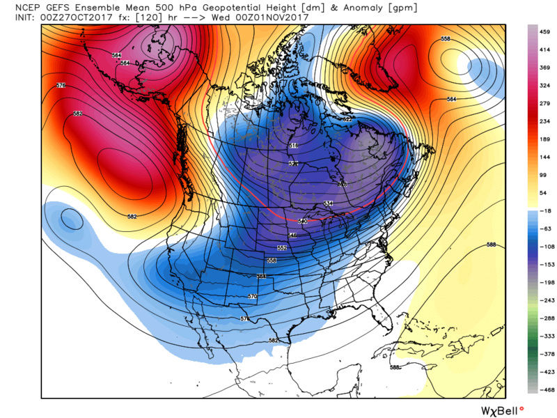
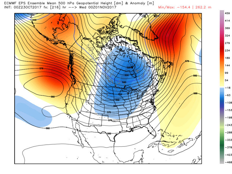
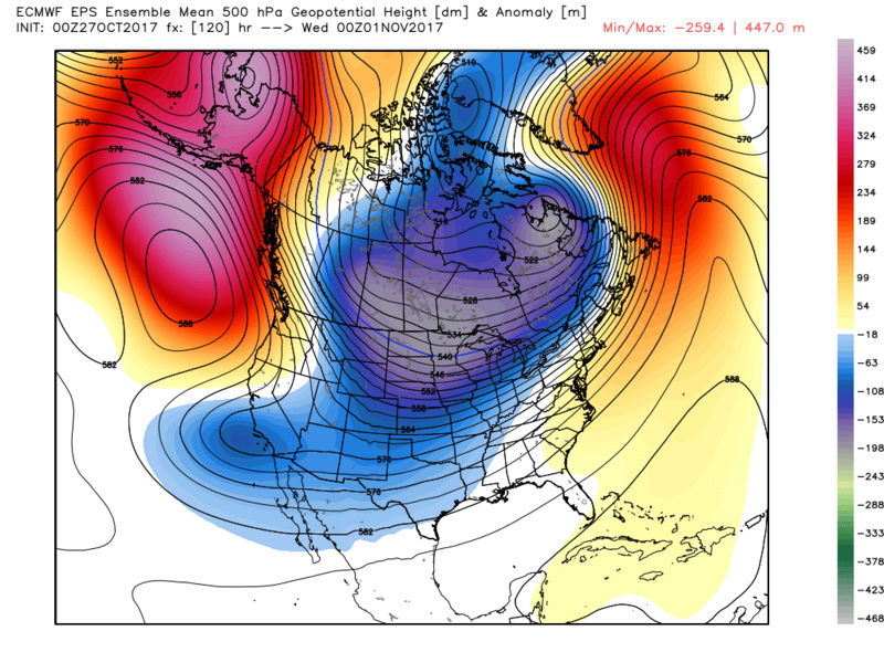
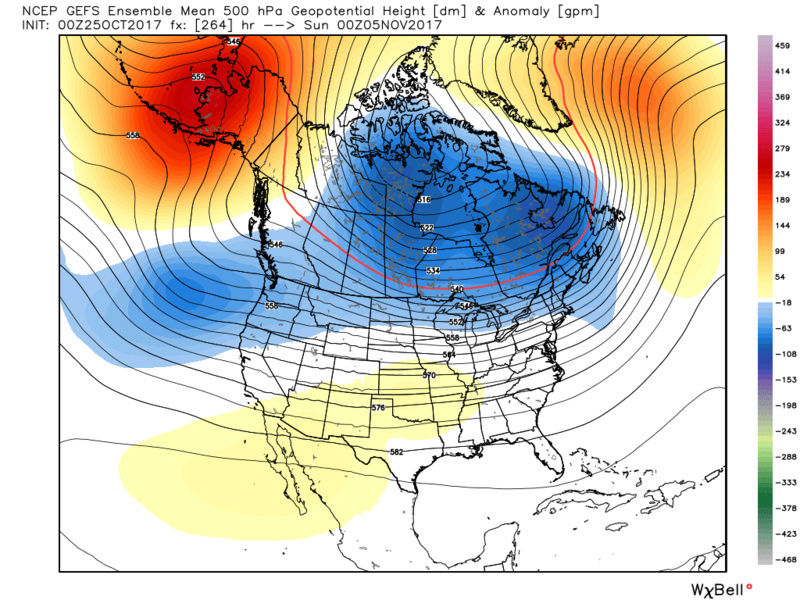
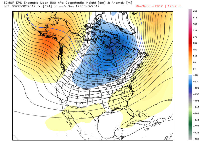
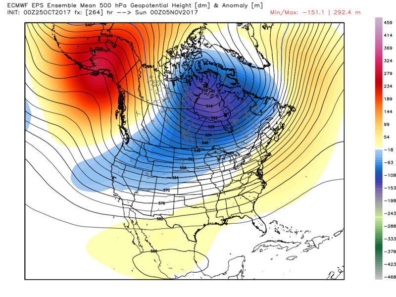
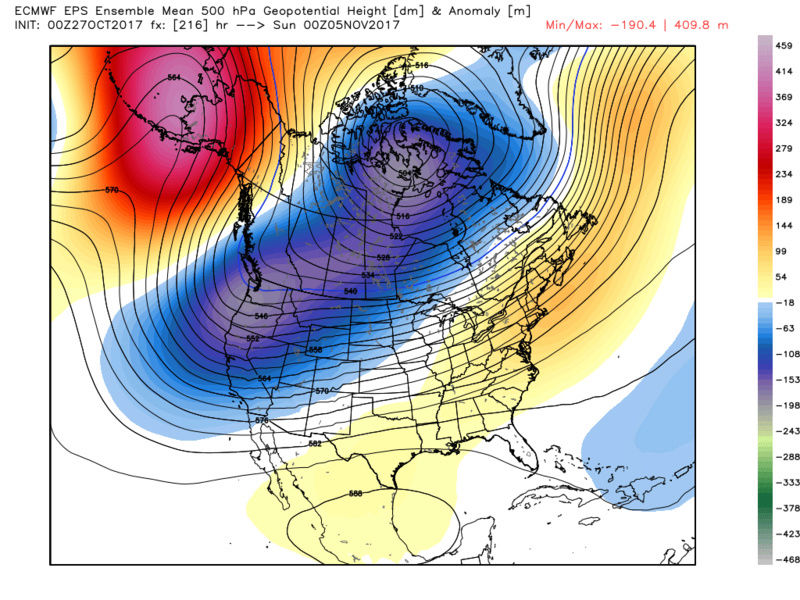
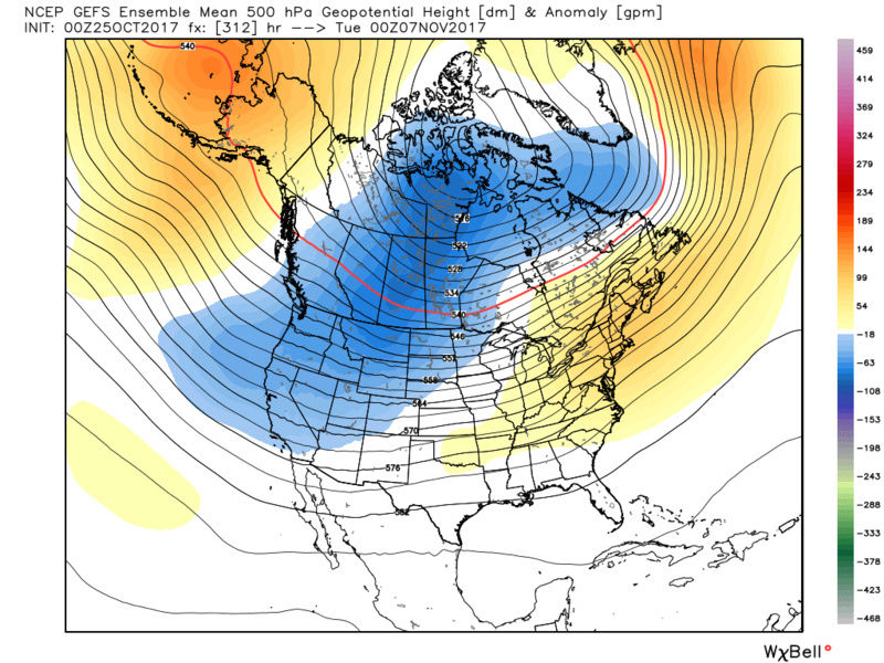
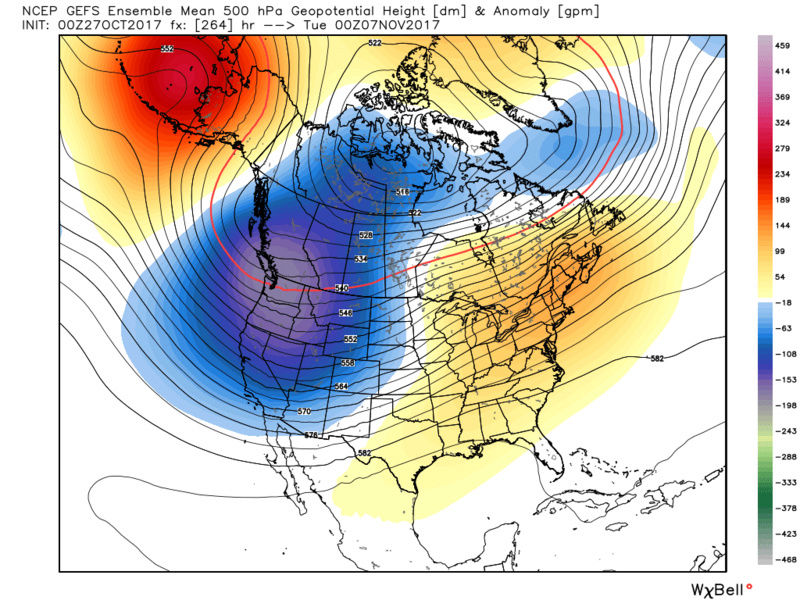
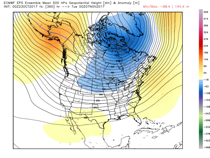
Now talk is cheap so lets look at the modeling and see if there is any evidence to back up my ideas. What I am going to show is the evolution of the pattern through the ensemble mean forecasts. When large scale pattern changes are at play looking at operational runs will be way too volatile run to run so I look at the avg. of the ensembles to see where we are trending with the big picture. Below will be the GEFS then the EPS for various dates. It has been my contention that without the effects of a recurving typhoon and a favorable MJO we go back toward the trough west ridge east configuration and above normal temps as we head into the first week of Nov and should last at least until mid month. Beyond that I'm not sure yet.
Pay particular attention the the trough pulling back to the west and north with successive model runs. Consequentially we get the ridge to go up in the east as we go forward in time. I expect to be on avg between 4-8* above normal from the Nov3rd-5th time frame and beyond. Nov 1st-3rd should avg around normal to a few degrees above normal.
GEFS first then EPS. All runs are from 00z Oct 23rd, Oct 25th, and Oct 27th: Follow the evolution:
November 1st:
GEFS


EPS

November 5th:
GEFS


EPS
November 7th:
GEFS
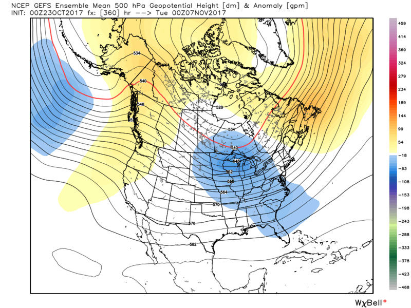
EPS


_________________
"In weather and in life, there's no winning and losing; there's only winning and learning."
WINTER 2012/2013 TOTALS 43.65"WINTER 2017/2018 TOTALS 62.85" WINTER 2022/2023 TOTALS 4.9"
WINTER 2013/2014 TOTALS 64.85"WINTER 2018/2019 TOTALS 14.25" WINTER 2023/2024 TOTALS 13.1"
WINTER 2014/2015 TOTALS 71.20"WINTER 2019/2020 TOTALS 6.35"
WINTER 2015/2016 TOTALS 35.00"WINTER 2020/2021 TOTALS 37.75"
WINTER 2016/2017 TOTALS 42.25"WINTER 2021/2022 TOTALS 31.65"

sroc4- Admin

- Posts : 8331
Reputation : 301
Join date : 2013-01-07
Location : Wading River, LI
Re: 2017-18 Winter Discussion thread
![]() by sroc4 Fri Oct 27, 2017 8:40 am
by sroc4 Fri Oct 27, 2017 8:40 am

As you can see that for pretty much the end of Sept and most of Oct the SOI has been very strongly positive. The last week we have a neutral SOI. Now with how significantly positive and for how long it has been positive one would expect there has to be a relaxation at some point. If it didn't we would head straight to a mod or strong La Nina. I don't expect that. Recall what we are looking at with the SOI. When positive(negative) there is Higher(lower) pressures over Tahiti relative to low(high) pressure over Darwin Australia. As we all know air moves from HP to LP, so the greater the difference in HP to LP between these two location, the stronger the air moves over the tropical Pac. With the last month being so strongly positive and such strong easterlies over the trop Pacwe have had all Nina regions cool significantly. However as you can see above we have started a period of relaxation to the easterlies. Again lets ask the question why?
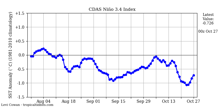
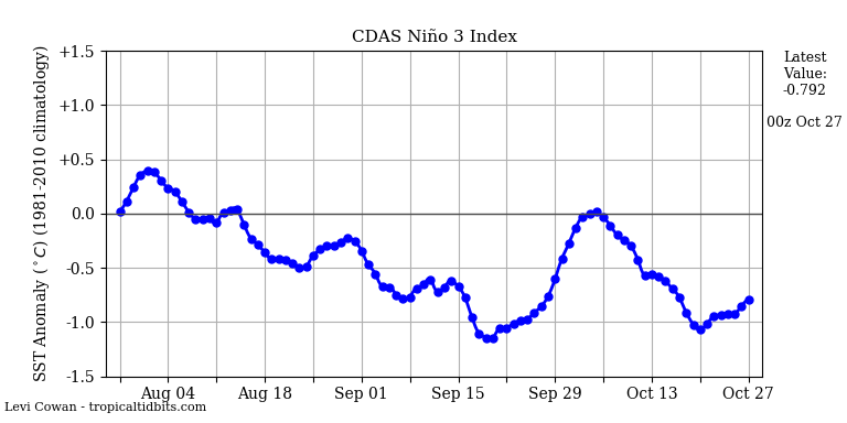
Before I go further: Picture the last month of (positive SOI)strong easterlies (winds blowing from the east to the west) over the Trop Pac like a strong fan over the surface of a bathtub. For the last month we have been piling up the water in the western half of the pacific(bathtub). Now turn the fan down, or turn it off all together and what happens? All the warm water that has been pushed west will reflexively slosh back east without the influences of the fan. So the current increase in the Nina regions is likely a reflexive event and NOT the end of the La Nina. As this current active MJO wave dies down I expect to see the ENSO region cool once again. How much will be determined by if we get another prolonged period of stronger easterlies vs back and forth between Neutral, weak neg and positive.
So here is the why we are entering a period of relaxation to the SOI and easterlies. See below and recall what the MJO is....A broad area of convection propagating west to east over the Trop Pac over time. Convection equals rising air which implies low pressure. So when looking at the map below it makes sense that our SOI has entered a state of relaxation(weaker winds from east to west), because as the MJO wave propagates further east the pressures near Tahiti are dropping relative to Darwin. Remember we started the Month is phase 4 and moved east from there. Follow the LP. With lower pressures now propagating to the east relative to now higher pressures to the west one can visualize the air wanting to now move more west to east or at least slowing east to west. Looking back at our MJO we started in 4 and propagated through 5, 6, 7 and now possibly 8, ad 1. So when or if the MJO quiets down in the eastern phases pressures should rise again near Tahiti relative to Darwin and we should go back to a mostly positive SOI phase. Again the details of this over the next month are fuzzy for now. The next ten days when looking at the MSLP anomalies over the equatorial Pac lead me to believe that we will likely fluctuate between neutral and positive.

Now here is my final thoughts about winter going forward and my major concerns. In general I worry mightily about the overall SSTA alignment in the Trop and N Pac.
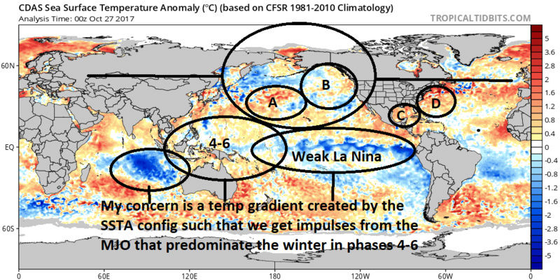
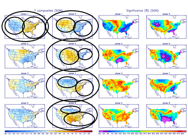
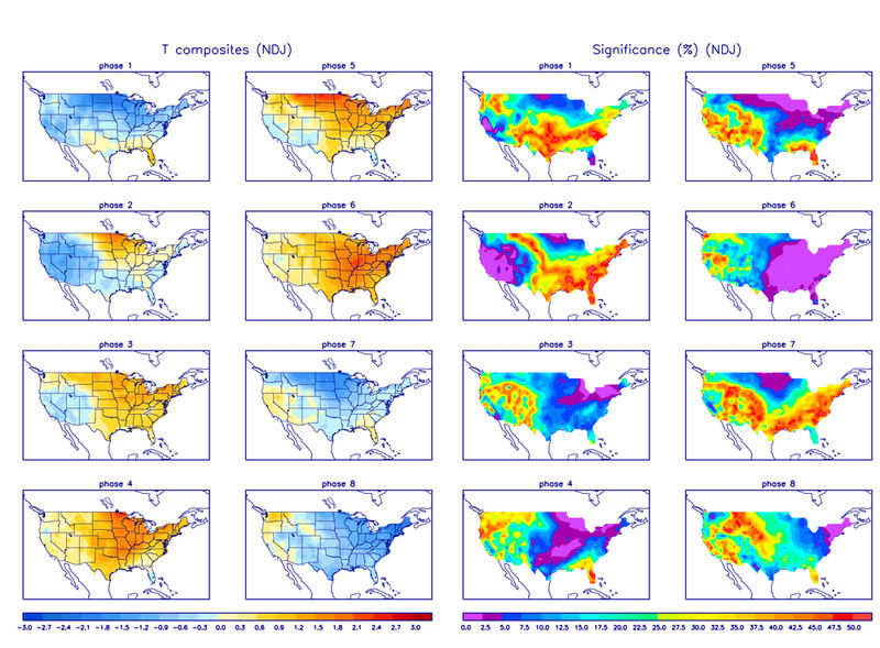
Al you asked the question about the cold anomalies on the E Indian Ocean. Combined with the ENSO region I worry we create a temp gradient in this area such that we may have MJO flare ups in the phases 4-6 more frequently that the other phases. This time of year, as we mentioned in the above write up, promote cold in the east but look at the temp composites for the Dec-Feb time frame. The exact opposite.
Combine this with a weak La Nina base state and I fear that the Trough West/ridge east will dominate the pattern on average. Now that is not to say we cant get periods of cold and snow. Again as has been mentioned by me and others the QBO is in a state that favors sudden strat warming events which if positioned favorably wmay lead to periods of (usually 1-3 weeks depending on the strength of the SSWE) of high lat blocking
_________________
"In weather and in life, there's no winning and losing; there's only winning and learning."
WINTER 2012/2013 TOTALS 43.65"WINTER 2017/2018 TOTALS 62.85" WINTER 2022/2023 TOTALS 4.9"
WINTER 2013/2014 TOTALS 64.85"WINTER 2018/2019 TOTALS 14.25" WINTER 2023/2024 TOTALS 13.1"
WINTER 2014/2015 TOTALS 71.20"WINTER 2019/2020 TOTALS 6.35"
WINTER 2015/2016 TOTALS 35.00"WINTER 2020/2021 TOTALS 37.75"
WINTER 2016/2017 TOTALS 42.25"WINTER 2021/2022 TOTALS 31.65"
sroc4- Admin
- Posts : 8331
Reputation : 301
Join date : 2013-01-07
Location : Wading River, LI
Re: 2017-18 Winter Discussion thread
![]() by sroc4 Fri Oct 27, 2017 11:08 am
by sroc4 Fri Oct 27, 2017 11:08 am
To summarize the above write ups after the 31st a shift back towards a warmer east between 1st-3rd begins and really takes hold between 3rd-5th is becoming increasingly likely. The duration of which looks to persist into at least the middle November, but I suspect it extends a tad further unless something else develops to reconfigure the atmosphere, ie: SSWE or MJO amplification into favorable phases.
Overall I am favoring a warm east cool west configuration throughout the majority of the Dec-F timeframe as well unless simliar big picture pattern enhancers develop.
I also expect the ENSO to cont, albeit more slowly, to trend with cooler anomalies until end of Nov or Dec time frame.
_________________
"In weather and in life, there's no winning and losing; there's only winning and learning."
WINTER 2012/2013 TOTALS 43.65"WINTER 2017/2018 TOTALS 62.85" WINTER 2022/2023 TOTALS 4.9"
WINTER 2013/2014 TOTALS 64.85"WINTER 2018/2019 TOTALS 14.25" WINTER 2023/2024 TOTALS 13.1"
WINTER 2014/2015 TOTALS 71.20"WINTER 2019/2020 TOTALS 6.35"
WINTER 2015/2016 TOTALS 35.00"WINTER 2020/2021 TOTALS 37.75"
WINTER 2016/2017 TOTALS 42.25"WINTER 2021/2022 TOTALS 31.65"
sroc4- Admin
- Posts : 8331
Reputation : 301
Join date : 2013-01-07
Location : Wading River, LI
Re: 2017-18 Winter Discussion thread
![]() by rb924119 Fri Oct 27, 2017 4:51 pm
by rb924119 Fri Oct 27, 2017 4:51 pm
rb924119- Meteorologist

- Posts : 6889
Reputation : 194
Join date : 2013-02-06
Age : 32
Location : Greentown, Pa
Re: 2017-18 Winter Discussion thread
![]() by amugs Fri Oct 27, 2017 5:17 pm
by amugs Fri Oct 27, 2017 5:17 pm
_________________
Mugs
AKA:King: Snow Weenie
Self Proclaimed
WINTER 2014-15 : 55.12" +.02 for 6 coatings (avg. 35")
WINTER 2015-16 Total - 29.8" (Avg 35")
WINTER 2016-17 : 39.5" so far
amugs- Advanced Forecaster - Mod
- Posts : 15091
Reputation : 213
Join date : 2013-01-07
Age : 54
Location : Hillsdale,NJ
Re: 2017-18 Winter Discussion thread
![]() by sroc4 Sat Oct 28, 2017 6:40 am
by sroc4 Sat Oct 28, 2017 6:40 am
Mugs def think QBO and low solar are variables in the overall equation the true effects of which on any given season like you said are poorly understood at best even by the pros. In my research I found similar results as you in that with the -QBO statistically we have much higher chances at high lat blocking. Indirectly coorolating with the ability of sudden stratospheric warming events(SSWE) which when strong enough the warm expanding air of the strat presses down on the troposphere lowering heights and discharging cold air masses into the lower lats. Of course like manty things location is everything. Last year the center of the warming events was on the wrong side of the N Hempsiphere and Asia was in the freezer for most of the season last year.
Now as far as low solar vs high solar, max vs min etc, and measurements of these things is all brand knew to the meteorological world relatively speaking. I know even less about the solar aspect than the QBO.
I need a few more years of developing my current understanding of the QBO and solar components before I feel comfortable truly incorporating it into any specific season beyond what I did above stating that the current -QBO does statistically increase our odds for SSWE and high lat blocking this season which is a variable for the winter. But that said the conditions here on the surface, specifically the current SSTA are aligned such that without a SSWE or a strong MJO in a favorable phase we are more likely to see warmer anomalies in the east.
Mugs any idea when Isotherm is going to post his winter outlook? And Frank yours usually comes out around Thanksgiving right?
_________________
"In weather and in life, there's no winning and losing; there's only winning and learning."
WINTER 2012/2013 TOTALS 43.65"WINTER 2017/2018 TOTALS 62.85" WINTER 2022/2023 TOTALS 4.9"
WINTER 2013/2014 TOTALS 64.85"WINTER 2018/2019 TOTALS 14.25" WINTER 2023/2024 TOTALS 13.1"
WINTER 2014/2015 TOTALS 71.20"WINTER 2019/2020 TOTALS 6.35"
WINTER 2015/2016 TOTALS 35.00"WINTER 2020/2021 TOTALS 37.75"
WINTER 2016/2017 TOTALS 42.25"WINTER 2021/2022 TOTALS 31.65"
sroc4- Admin
- Posts : 8331
Reputation : 301
Join date : 2013-01-07
Location : Wading River, LI
Re: 2017-18 Winter Discussion thread
![]() by amugs Sat Oct 28, 2017 5:59 pm
by amugs Sat Oct 28, 2017 5:59 pm
Yup concur with you on the above post so far. Need to see what PDO looks like and if the tongue of warm water keep.moving into that region. If so N EPO not severe but could enhance the cold in the east.
Time will tell.
_________________
Mugs
AKA:King: Snow Weenie
Self Proclaimed
WINTER 2014-15 : 55.12" +.02 for 6 coatings (avg. 35")
WINTER 2015-16 Total - 29.8" (Avg 35")
WINTER 2016-17 : 39.5" so far
amugs- Advanced Forecaster - Mod
- Posts : 15091
Reputation : 213
Join date : 2013-01-07
Age : 54
Location : Hillsdale,NJ
Re: 2017-18 Winter Discussion thread
![]() by algae888 Mon Oct 30, 2017 4:27 pm
by algae888 Mon Oct 30, 2017 4:27 pm

algae888- Advanced Forecaster
- Posts : 5311
Reputation : 46
Join date : 2013-02-05
Age : 61
Location : mt. vernon, new york
Re: 2017-18 Winter Discussion thread
![]() by algae888 Fri Nov 03, 2017 5:10 am
by algae888 Fri Nov 03, 2017 5:10 am
1) the cold pool in the indian ocean has warmed quite a bit. gradient should set up further east near date line if this continues along with point 2.
2) we are most likely going to have a east based nina. with a very sharp drop in sst from west to east. also supports gradient to set up near dateline

3) pdo region warming. good sign. let's see if this can continue.
we are very close now with regards to how enso will effect our winter pattern. we are less than a month til met winter. I would not be surprised if we see more nino like conditions (at least at times) this winter with the set up in the pacific.
algae888- Advanced Forecaster
- Posts : 5311
Reputation : 46
Join date : 2013-02-05
Age : 61
Location : mt. vernon, new york
Re: 2017-18 Winter Discussion thread
![]() by RJB8525 Fri Nov 03, 2017 9:24 am
by RJB8525 Fri Nov 03, 2017 9:24 am


RJB8525- Senior Enthusiast

- Posts : 1994
Reputation : 28
Join date : 2013-02-06
Age : 38
Location : Hackettstown, NJ
Re: 2017-18 Winter Discussion thread
![]() by frank 638 Fri Nov 03, 2017 9:26 am
by frank 638 Fri Nov 03, 2017 9:26 am
frank 638- Senior Enthusiast
- Posts : 2823
Reputation : 37
Join date : 2016-01-01
Age : 40
Location : bronx ny
Re: 2017-18 Winter Discussion thread
![]() by algae888 Fri Nov 03, 2017 10:08 am
by algae888 Fri Nov 03, 2017 10:08 am
That would be good newsfrank 638 wrote:I hate to ask is this good news or bad news for us snow weenies
algae888- Advanced Forecaster
- Posts : 5311
Reputation : 46
Join date : 2013-02-05
Age : 61
Location : mt. vernon, new york
Re: 2017-18 Winter Discussion thread
![]() by algae888 Fri Nov 03, 2017 10:21 am
by algae888 Fri Nov 03, 2017 10:21 am
algae888- Advanced Forecaster
- Posts : 5311
Reputation : 46
Join date : 2013-02-05
Age : 61
Location : mt. vernon, new york
Re: 2017-18 Winter Discussion thread
![]() by algae888 Fri Nov 03, 2017 11:49 am
by algae888 Fri Nov 03, 2017 11:49 am
algae888- Advanced Forecaster
- Posts : 5311
Reputation : 46
Join date : 2013-02-05
Age : 61
Location : mt. vernon, new york
Re: 2017-18 Winter Discussion thread
![]() by sroc4 Fri Nov 03, 2017 12:23 pm
by sroc4 Fri Nov 03, 2017 12:23 pm
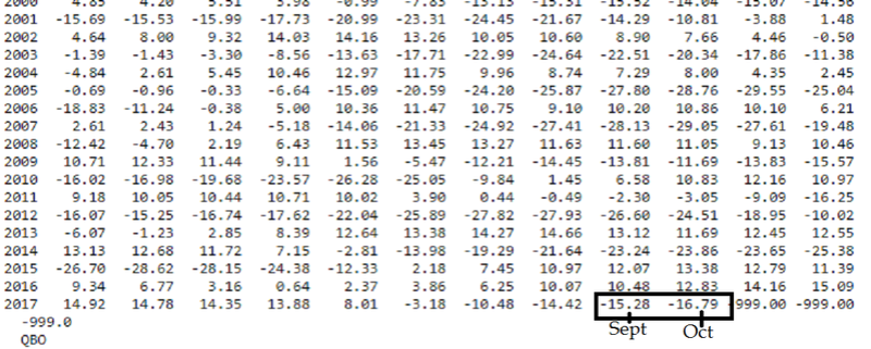
algae888 wrote:Qbo less neg for october -16.79 to currently -15.28. We do not want it to go any lower negative if it becomes too negative it could hinder blocking so another good sign today
If im not mistaken Al I think you meant to say the QBO went more negative for October as it went from -15.28 to -16.79? Personally I think QBO is still not properly understood to make any definitive statements about about the change in numbers. Too many other factors that go along with driving the pattern. Esp this year. For instance look at the 2005-2006, 2009-2010, and 2014-2015 all well above normal snowfall and decent periods of cold though out the Dec-March time frame of those years yet had stronger negative than what we have right now.
https://www.esrl.noaa.gov/psd/data/correlation/qbo.data
http://www.weather.gov/media/okx/Climate/CentralPark/monthlyseasonalsnowfall.pdf
_________________
"In weather and in life, there's no winning and losing; there's only winning and learning."
WINTER 2012/2013 TOTALS 43.65"WINTER 2017/2018 TOTALS 62.85" WINTER 2022/2023 TOTALS 4.9"
WINTER 2013/2014 TOTALS 64.85"WINTER 2018/2019 TOTALS 14.25" WINTER 2023/2024 TOTALS 13.1"
WINTER 2014/2015 TOTALS 71.20"WINTER 2019/2020 TOTALS 6.35"
WINTER 2015/2016 TOTALS 35.00"WINTER 2020/2021 TOTALS 37.75"
WINTER 2016/2017 TOTALS 42.25"WINTER 2021/2022 TOTALS 31.65"
sroc4- Admin
- Posts : 8331
Reputation : 301
Join date : 2013-01-07
Location : Wading River, LI
Re: 2017-18 Winter Discussion thread
![]() by algae888 Fri Nov 03, 2017 1:51 pm
by algae888 Fri Nov 03, 2017 1:51 pm
No scott it was 16.79 in September and 15.28 in October that's what I meant to say I know it's confusing using negative numbers. Anyway just reading an article on the Qbo yes it's not very well understood. Also while we are in the negative phase at 30 millibars we are currently in the positive phase heading towards negative in the 40 to50 Millibar range which I believe is the lower stratosphere. Anyway what I believe is true is that we don't want it to be too strongly positive or too strongly negative as it could hinder high-latitude blocking correct me if I'm wrong as I am not well versed in thissroc4 wrote:algae888 wrote:Qbo less neg for october -16.79 to currently -15.28. We do not want it to go any lower negative if it becomes too negative it could hinder blocking so another good sign today
If im not mistaken Al I think you meant to say the QBO went more negative for October as it went from -15.28 to -16.79? Personally I think QBO is still not properly understood to make any definitive statements about about the change in numbers. Too many other factors that go along with driving the pattern. Esp this year. For instance look at the 2005-2006, 2009-2010, and 2014-2015 all well above normal snowfall and decent periods of cold though out the Dec-March time frame of those years yet had stronger negative than what we have right now.
https://www.esrl.noaa.gov/psd/data/correlation/qbo.data
http://www.weather.gov/media/okx/Climate/CentralPark/monthlyseasonalsnowfall.pdf
algae888- Advanced Forecaster
- Posts : 5311
Reputation : 46
Join date : 2013-02-05
Age : 61
Location : mt. vernon, new york
Re: 2017-18 Winter Discussion thread
![]() by algae888 Fri Nov 03, 2017 1:54 pm
by algae888 Fri Nov 03, 2017 1:54 pm
algae888- Advanced Forecaster
- Posts : 5311
Reputation : 46
Join date : 2013-02-05
Age : 61
Location : mt. vernon, new york
Re: 2017-18 Winter Discussion thread
![]() by sroc4 Fri Nov 03, 2017 2:51 pm
by sroc4 Fri Nov 03, 2017 2:51 pm
As far as my understanding you are correct in saying the the extremes on both sides of the spectrum, ie: too positive or too negative, statistically speaking favor against high lat blocking with a stronger negative being better than a strong positive if we. But overall these are loose statistics as I showed above there are winters that buck the trends. I remember having a discussion with a met (cant remember who) a few years back who said "ideal" was between +10 to -10, but honestly Im not sure anyone knows for sure.
As far as the -EPO and the -WPO I am not calling it Giggidy worthy because I am concerned its not enough to overwhelm the other pattern pieces in place. Although throughout the ensemble runs ithe -EPO and WPO are present they are trending closer to neutral as we head out in time. And like all good things they have to come to an end, or at least reload. My concern is that these nice teleconnetion couplet will lead to a couple of transient cold shots and that's it. The AO and NAO you mentioned above unfort cont to look positive to me on both the graphs and the models. The PNA also looks to remain negative similarly. I can see the cold shot coming around the 8th-11th or so but I believe it is in response to the MJO headed towards phase 2. If the GFS is correct we take another trip through warm phases 3-5 thereafter and the ensembles are already hinting at the return to a similar pattern that we see today.

As far as the -EPO/-WPO couplet this isnt doing anthing to the stratosphere. Not a thing right now. There are no forecasted strong wave 1 or wave 2 attacks as we speak, and the strat is currently getting a little colder not warmer between 70-10mbs.
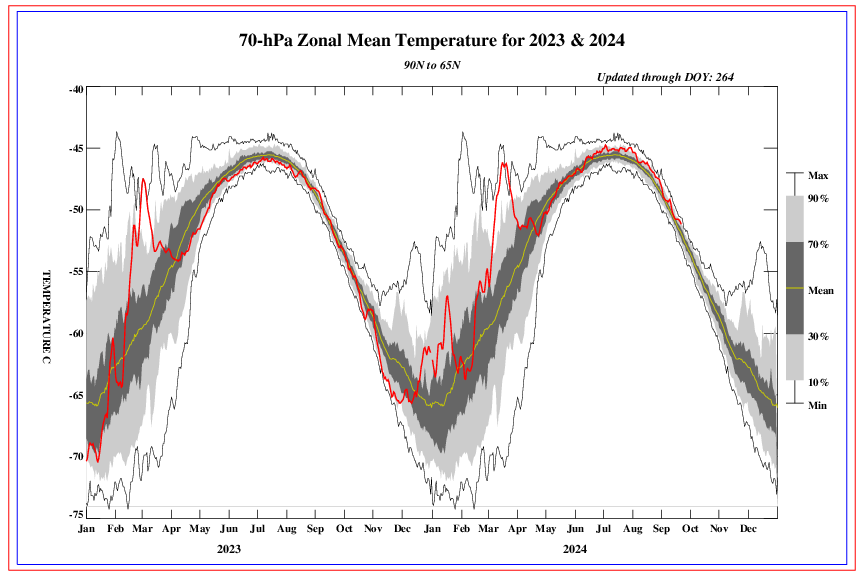
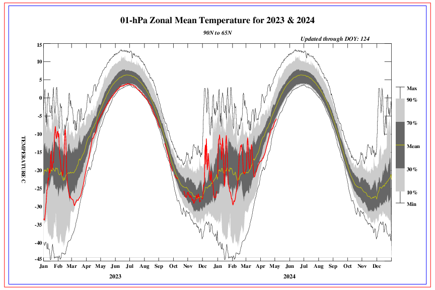
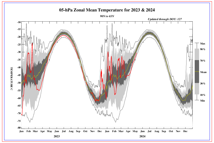
Between 1mb and 5 mb a little warming is occuring but the temp is still below normal.
_________________
"In weather and in life, there's no winning and losing; there's only winning and learning."
WINTER 2012/2013 TOTALS 43.65"WINTER 2017/2018 TOTALS 62.85" WINTER 2022/2023 TOTALS 4.9"
WINTER 2013/2014 TOTALS 64.85"WINTER 2018/2019 TOTALS 14.25" WINTER 2023/2024 TOTALS 13.1"
WINTER 2014/2015 TOTALS 71.20"WINTER 2019/2020 TOTALS 6.35"
WINTER 2015/2016 TOTALS 35.00"WINTER 2020/2021 TOTALS 37.75"
WINTER 2016/2017 TOTALS 42.25"WINTER 2021/2022 TOTALS 31.65"
sroc4- Admin
- Posts : 8331
Reputation : 301
Join date : 2013-01-07
Location : Wading River, LI
Re: 2017-18 Winter Discussion thread
![]() by algae888 Fri Nov 03, 2017 5:17 pm
by algae888 Fri Nov 03, 2017 5:17 pm
algae888- Advanced Forecaster
- Posts : 5311
Reputation : 46
Join date : 2013-02-05
Age : 61
Location : mt. vernon, new york
Re: 2017-18 Winter Discussion thread
![]() by amugs Fri Nov 03, 2017 11:11 pm
by amugs Fri Nov 03, 2017 11:11 pm
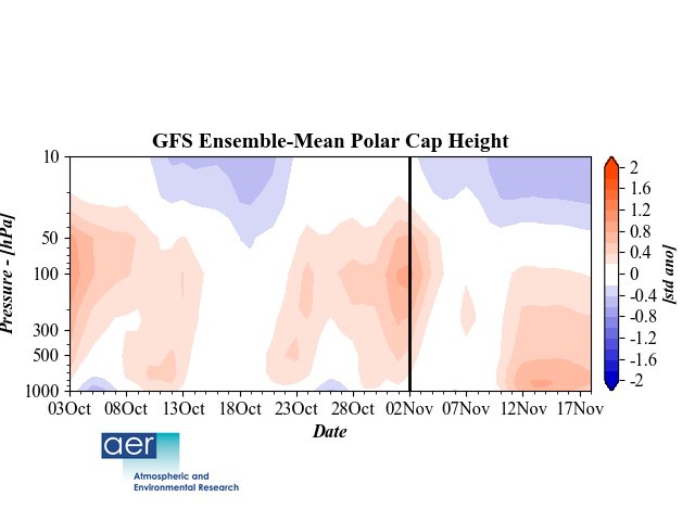
Latest showing a poleward Heat Flux by this chart from Dr Cohen that he put out yesterday.
Scott, it is a fugly loo lk on the GEFS for sure but the LR looks to be better as we progress through the week. Next weekend is Lomond much more late fall winteris looking. How long it holds remains to be seen but I see the Negative EPO as a good sign. Low solar and a N QBO which we don't have a clue idea how it works in depth but most indicators show from limited research that it has aN effect on the NAO to be more in a negative phase and also in conjuction helps with a more N AO state.
Euro next Sunday let's see where it goes from here the next few days.

_________________
Mugs
AKA:King: Snow Weenie
Self Proclaimed
WINTER 2014-15 : 55.12" +.02 for 6 coatings (avg. 35")
WINTER 2015-16 Total - 29.8" (Avg 35")
WINTER 2016-17 : 39.5" so far
amugs- Advanced Forecaster - Mod
- Posts : 15091
Reputation : 213
Join date : 2013-01-07
Age : 54
Location : Hillsdale,NJ
Page 5 of 6 • 1, 2, 3, 4, 5, 6 ![]()