
 Search
Long Range Thread 15.0
Page 18 of 42 •  1 ... 10 ... 17, 18, 19 ... 30 ... 42
 ![]()
Re: Long Range Thread 15.0
![]() by amugs Wed Dec 13, 2017 7:38 pm
by amugs Wed Dec 13, 2017 7:38 pm
amugs- Advanced Forecaster - Mod

- Posts : 15091
Join date : 2013-01-07
Re: Long Range Thread 15.0
![]() by skinsfan1177 Wed Dec 13, 2017 7:39 pm
by skinsfan1177 Wed Dec 13, 2017 7:39 pm
amugs wrote:Starts this weekend through the end of the year book it!!
Mugsy the 18z GFS was drool worthy. Things are going in the right direction
skinsfan1177- Senior Enthusiast

- Posts : 4485
Join date : 2013-01-07
track17- Posts : 454
Reputation : 4
Join date : 2016-01-09
Re: Long Range Thread 15.0
![]() by skinsfan1177 Wed Dec 13, 2017 8:04 pm
by skinsfan1177 Wed Dec 13, 2017 8:04 pm
track17 wrote:Wow skins can you tell us about it
Just need to wait and see if it comes to fruition

skinsfan1177- Senior Enthusiast
- Posts : 4485
Reputation : 35
Join date : 2013-01-07
Age : 46
Location : Point Pleasant Boro
track17- Posts : 454
Reputation : 4
Join date : 2016-01-09
Re: Long Range Thread 15.0
![]() by hyde345 Wed Dec 13, 2017 11:51 pm
by hyde345 Wed Dec 13, 2017 11:51 pm

hyde345- Pro Enthusiast

- Posts : 1082
Reputation : 48
Join date : 2013-01-08
Location : Hyde Park, NY

mmanisca- Pro Enthusiast
- Posts : 298
Reputation : 3
Join date : 2013-01-23
Age : 65
Location : Deer Park, Long Island
Re: Long Range Thread 15.0
![]() by docstox12 Thu Dec 14, 2017 6:06 am
by docstox12 Thu Dec 14, 2017 6:06 am

docstox12- Wx Statistician Guru

- Posts : 8497
Reputation : 222
Join date : 2013-01-07
Age : 73
Location : Monroe NY
Re: Long Range Thread 15.0
![]() by Frank_Wx Thu Dec 14, 2017 6:23 am
by Frank_Wx Thu Dec 14, 2017 6:23 am

Verbatim, yes, this is a warm pattern on the latest GEFS Christmas Eve into Day with the SE Ridge flexing all the way up the coast. However, one may think with the anomalous Pacific (EPO) blocking, the trough would be shifted further east and the PV should be a little more south.

In addition, the MJO is forecasted to become active into cold phases. Typically models do a very poor job of seeing the MJO until it's actually happening. Given Christmas is still about 10 days away, I would ignore what models are saying right now and give it a few days. Possibly until Monday of next week.
_________________
_______________________________________________________________________________________________________
CLICK HERE to view NJ Strong Snowstorm Classifications

Frank_Wx- Godzilla Seeker

- Posts : 21305
Reputation : 328
Join date : 2013-01-05
Age : 31
Location : Jersey City, NJ -

SENJsnowman- Senior Enthusiast
- Posts : 1186
Reputation : 61
Join date : 2017-01-06
Age : 51
Location : Bayville, NJ
Re: Long Range Thread 15.0
![]() by sroc4 Thu Dec 14, 2017 7:40 am
by sroc4 Thu Dec 14, 2017 7:40 am
Frank_Wx wrote:I am not sold on a mild Christmas just yet. While it will get milder early next week, there is a chance it can get cold again right around Christmas.
Verbatim, yes, this is a warm pattern on the latest GEFS Christmas Eve into Day with the SE Ridge flexing all the way up the coast. However, one may think with the anomalous Pacific (EPO) blocking, the trough would be shifted further east and the PV should be a little more south.
In addition, the MJO is forecasted to become active into cold phases. Typically models do a very poor job of seeing the MJO until it's actually happening. Given Christmas is still about 10 days away, I would ignore what models are saying right now and give it a few days. Possibly until Monday of next week.
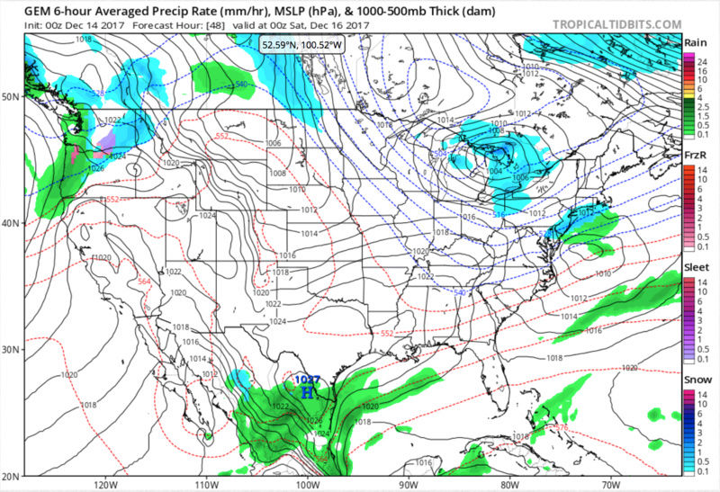
Agreed Frank. The later in the year it is the stronger the cold air influence can be. With Cold air much more dense than warm air when there is a fight, cold air mass digging south vs warm air mass flexing north the deeper into the winter season the more likely the cold wins out, esp with the set up in front of us. With the EPO going to be as negative as it is forecasted there will be a really strong surge of cold air diving down strait from he arctic. This will go up against said SE ridge. With Nina effects being weak to mod at best with a 500mb strong poleward ridge building back into the EPO and AO regions at least , (+/- NAO region) we will likely see the cold air win out. Take a look at the surface map for the same time frame you posted the 500mb above:

With a 1037HP in all of W Canada this WILL drive the arctic air into the CONUS. One would expect as the models catch onto the pattern that the Canadian HP, under the poleward ridging at 500mb, will build in further east over the GL into SE Canada pushing back the SE ridge and surface Bemuda HP effectively creating a strong HP block over the GL. The LP, which appears to be cutting to the west into the GL on this image, would likely be forced to come off the EC somewhere between NC and the DelMarVa. This LP on this map could very well be the SECS or MECS that Isotherm has been calling for in this timeframe.
In reality this could also be a case of the cold being so strong that the storm track is even further S than that. We want a little push from the SE ridge to set up the gradient just right. With an EPO forecasted to be as negative as it is the gradient set up too far south is certainly possible. But I totally agree.... with MJO headed towards favorable phases, an EPO and AO forcasted the way they are, the strat forecasted the way it is, and a trough forecasted to be centered near Hawaii during this time frame this warm look WILL NOT END UP WARM. Expect the models to correct with time.
_________________
"In weather and in life, there's no winning and losing; there's only winning and learning."
WINTER 2012/2013 TOTALS 43.65"WINTER 2017/2018 TOTALS 62.85" WINTER 2022/2023 TOTALS 4.9"
WINTER 2013/2014 TOTALS 64.85"WINTER 2018/2019 TOTALS 14.25" WINTER 2023/2024 TOTALS 13.1"
WINTER 2014/2015 TOTALS 71.20"WINTER 2019/2020 TOTALS 6.35"
WINTER 2015/2016 TOTALS 35.00"WINTER 2020/2021 TOTALS 37.75"
WINTER 2016/2017 TOTALS 42.25"WINTER 2021/2022 TOTALS 31.65"

sroc4- Admin
- Posts : 8331
Reputation : 301
Join date : 2013-01-07
Location : Wading River, LI
Re: Long Range Thread 15.0
![]() by sroc4 Thu Dec 14, 2017 7:50 am
by sroc4 Thu Dec 14, 2017 7:50 am

_________________
"In weather and in life, there's no winning and losing; there's only winning and learning."
WINTER 2012/2013 TOTALS 43.65"WINTER 2017/2018 TOTALS 62.85" WINTER 2022/2023 TOTALS 4.9"
WINTER 2013/2014 TOTALS 64.85"WINTER 2018/2019 TOTALS 14.25" WINTER 2023/2024 TOTALS 13.1"
WINTER 2014/2015 TOTALS 71.20"WINTER 2019/2020 TOTALS 6.35"
WINTER 2015/2016 TOTALS 35.00"WINTER 2020/2021 TOTALS 37.75"
WINTER 2016/2017 TOTALS 42.25"WINTER 2021/2022 TOTALS 31.65"
sroc4- Admin
- Posts : 8331
Reputation : 301
Join date : 2013-01-07
Location : Wading River, LI
Re: Long Range Thread 15.0
![]() by Guest Thu Dec 14, 2017 7:55 am
by Guest Thu Dec 14, 2017 7:55 am
Guest- Guest
Re: Long Range Thread 15.0
![]() by mmanisca Thu Dec 14, 2017 7:59 am
by mmanisca Thu Dec 14, 2017 7:59 am
Frank_Wx wrote:I am not sold on a mild Christmas just yet. While it will get milder early next week, there is a chance it can get cold again right around Christmas.
Verbatim, yes, this is a warm pattern on the latest GEFS Christmas Eve into Day with the SE Ridge flexing all the way up the coast. However, one may think with the anomalous Pacific (EPO) blocking, the trough would be shifted further east and the PV should be a little more south.
In addition, the MJO is forecasted to become active into cold phases. Typically models do a very poor job of seeing the MJO until it's actually happening. Given Christmas is still about 10 days away, I would ignore what models are saying right now and give it a few days. Possibly until Monday of next week.
mmanisca- Pro Enthusiast
- Posts : 298
Reputation : 3
Join date : 2013-01-23
Age : 65
Location : Deer Park, Long Island
Re: Long Range Thread 15.0
![]() by amugs Thu Dec 14, 2017 8:42 am
by amugs Thu Dec 14, 2017 8:42 am
The higher North Atlantic heights in conjunction with a robust PNA/EPO should flood the northern tier of the United States in cold. Confluence and strong arctic highs will drain into the region and press the baroclinic zone south and east as the gradient provides a strong corridor for lift and convergence. These patterns ultimately suppress and counteract the se ridge in a fashion that is favorable for the northern middle Atlantic and New England. The models should adjust accordingly going forward. These are often some of the most challenging synoptic setups for them to compute. Don’t get to fixated on guidance variance over the next couple of days, it will eventually get ironed out. We know the global and large scale hemispheric pattern support such
_________________
Mugs
AKA:King: Snow Weenie
Self Proclaimed
WINTER 2014-15 : 55.12" +.02 for 6 coatings (avg. 35")
WINTER 2015-16 Total - 29.8" (Avg 35")
WINTER 2016-17 : 39.5" so far

amugs- Advanced Forecaster - Mod
- Posts : 15091
Reputation : 213
Join date : 2013-01-07
Age : 54
Location : Hillsdale,NJ
Re: Long Range Thread 15.0
![]() by Guest Thu Dec 14, 2017 8:56 am
by Guest Thu Dec 14, 2017 8:56 am
amugs wrote:From a another board and says it very well IMO
The higher North Atlantic heights in conjunction with a robust PNA/EPO should flood the northern tier of the United States in cold. Confluence and strong arctic highs will drain into the region and press the baroclinic zone south and east as the gradient provides a strong corridor for lift and convergence. These patterns ultimately suppress and counteract the se ridge in a fashion that is favorable for the northern middle Atlantic and New England. The models should adjust accordingly going forward. These are often some of the most challenging synoptic setups for them to compute. Don’t get to fixated on guidance variance over the next couple of days, it will eventually get ironed out. We know the global and large scale hemispheric pattern support such
Amen. Bring er home Amugs. I’m tired of listening to Christmas songs about snow and dealing with rain and warmth. This year feels different.
Guest- Guest
Re: Long Range Thread 15.0
![]() by Armando Salvadore Thu Dec 14, 2017 10:00 am
by Armando Salvadore Thu Dec 14, 2017 10:00 am


Armando Salvadore- Advanced Forecaster

- Posts : 171
Reputation : 0
Join date : 2016-12-23
Location : Springfield, NJ
Re: Long Range Thread 15.0
![]() by hyde345 Thu Dec 14, 2017 10:21 am
by hyde345 Thu Dec 14, 2017 10:21 am
sroc4 wrote:Expect the outcome to shift the mean trough axis east, the center of the SE ridge axis to be further S&E, the negatives in the SW CONUS that currently look like a mean SW trough will likely cut off from the mean trough, back away a little(S and/or W), and higher heights will build in between the two(area where the red X is). The result will be pieces of energy breaking off this SW cutoff low that may interact with energy diving into the central CONUS on the back side of the Mean trough. Sound familiar? Don't believe the hype just yet
This makes a lot of sense so we will just have to wait and see how models adjust. It looks pretty quiet for next week or so then beyond 22nd is when things could get interesting. Which side of the gradient are we going to be on is the question.
hyde345- Pro Enthusiast
- Posts : 1082
Reputation : 48
Join date : 2013-01-08
Location : Hyde Park, NY
Re: Long Range Thread 15.0
![]() by amugs Thu Dec 14, 2017 10:29 am
by amugs Thu Dec 14, 2017 10:29 am
docstox12 wrote:Lee mentioning a warm up at the end of the month and little chance of a White Christmas here.Too bad about all this great cold air and just puke clippers and not a Miller A in the works.
Warmisist - drinking the wrong Cool Aid LOL!
_________________
Mugs
AKA:King: Snow Weenie
Self Proclaimed
WINTER 2014-15 : 55.12" +.02 for 6 coatings (avg. 35")
WINTER 2015-16 Total - 29.8" (Avg 35")
WINTER 2016-17 : 39.5" so far
amugs- Advanced Forecaster - Mod
- Posts : 15091
Reputation : 213
Join date : 2013-01-07
Age : 54
Location : Hillsdale,NJ
Re: Long Range Thread 15.0
![]() by docstox12 Thu Dec 14, 2017 10:43 am
by docstox12 Thu Dec 14, 2017 10:43 am
amugs wrote:docstox12 wrote:Lee mentioning a warm up at the end of the month and little chance of a White Christmas here.Too bad about all this great cold air and just puke clippers and not a Miller A in the works.
Warmisist - drinking the wrong Cool Aid LOL!
LOL, I am only the messenger my good man, only the messenger!!!
docstox12- Wx Statistician Guru
- Posts : 8497
Reputation : 222
Join date : 2013-01-07
Age : 73
Location : Monroe NY
Re: Long Range Thread 15.0
![]() by rb924119 Thu Dec 14, 2017 10:48 am
by rb924119 Thu Dec 14, 2017 10:48 am


rb924119- Meteorologist

- Posts : 6888
Reputation : 194
Join date : 2013-02-06
Age : 32
Location : Greentown, Pa
rb924119- Meteorologist
- Posts : 6888
Reputation : 194
Join date : 2013-02-06
Age : 32
Location : Greentown, Pa
Re: Long Range Thread 15.0
![]() by sroc4 Thu Dec 14, 2017 10:50 am
by sroc4 Thu Dec 14, 2017 10:50 am
docstox12 wrote:amugs wrote:docstox12 wrote:Lee mentioning a warm up at the end of the month and little chance of a White Christmas here.Too bad about all this great cold air and just puke clippers and not a Miller A in the works.
Warmisist - drinking the wrong Cool Aid LOL!
LOL, I am only the messenger my good man, only the messenger!!!
This cracked me up.

_________________
"In weather and in life, there's no winning and losing; there's only winning and learning."
WINTER 2012/2013 TOTALS 43.65"WINTER 2017/2018 TOTALS 62.85" WINTER 2022/2023 TOTALS 4.9"
WINTER 2013/2014 TOTALS 64.85"WINTER 2018/2019 TOTALS 14.25" WINTER 2023/2024 TOTALS 13.1"
WINTER 2014/2015 TOTALS 71.20"WINTER 2019/2020 TOTALS 6.35"
WINTER 2015/2016 TOTALS 35.00"WINTER 2020/2021 TOTALS 37.75"
WINTER 2016/2017 TOTALS 42.25"WINTER 2021/2022 TOTALS 31.65"
sroc4- Admin
- Posts : 8331
Reputation : 301
Join date : 2013-01-07
Location : Wading River, LI
Re: Long Range Thread 15.0
![]() by HectorO Thu Dec 14, 2017 11:28 am
by HectorO Thu Dec 14, 2017 11:28 am

HectorO- Pro Enthusiast
- Posts : 959
Reputation : 27
Join date : 2013-01-11
Re: Long Range Thread 15.0
![]() by rb924119 Thu Dec 14, 2017 11:30 am
by rb924119 Thu Dec 14, 2017 11:30 am
rb924119- Meteorologist
- Posts : 6888
Reputation : 194
Join date : 2013-02-06
Age : 32
Location : Greentown, Pa
Re: Long Range Thread 15.0
![]() by Guest Thu Dec 14, 2017 12:00 pm
by Guest Thu Dec 14, 2017 12:00 pm
HectorO wrote:If Lee says it i believe it. That guy tends to be more conservative, but seems to be one of my favorite to follow. That's why when he said snow was coming last week, then snow was coming lol.
I don’t know about you, but I find the guys on here like Scott and Frank, Isotherm etc; are SIGNIFICANTLY more accurate and willing to make early calls than ANY of the local media guys hands down!!!
Guest- Guest
Re: Long Range Thread 15.0
![]() by sroc4 Thu Dec 14, 2017 12:25 pm
by sroc4 Thu Dec 14, 2017 12:25 pm
Armando Salvadore wrote:Hello everyone, hope i'm not too late! Lol, hope all is well! Anyway, so yeah i'll just jump into the discussion. I'll say this regarding our tropical forcing, or whether or not it's just "noise", but take a look at the 200VP. It appears like it's remaining rather stationary across the MC/WP, reminiscent of last year and of course, following a NINA conventional standing wave. When looking at the CFS forecast of this wave, it'd appear to be the case, so the question is do we see a propagation of this wave, or constructive interference? Regardless though, thanks to a +EAMT and tropical forcing, we'll see a -EPO block manifest and in a big way thanks to wave breaking. We've seen guidance continue over the years, underestimate the extent of the low level cold anomalies. Also in our favor is that because it appears to be an active pattern, we'll see shortwaves eject out and this should also hinder the extent of the SE ridge.
I know your a busy man Mando but your posts in here are always appreciated. Hopefully they can become more common place. Thanks for the insight.
Thats interesting in that the standard phase plots from the GFS agrees with a recycling of the MJO to go along with where the GFS 200mb Pot V. anomalies are forecasted to go. However; the Euro disagrees and shows progression into the phase 8 and possibly 1.


_________________
"In weather and in life, there's no winning and losing; there's only winning and learning."
WINTER 2012/2013 TOTALS 43.65"WINTER 2017/2018 TOTALS 62.85" WINTER 2022/2023 TOTALS 4.9"
WINTER 2013/2014 TOTALS 64.85"WINTER 2018/2019 TOTALS 14.25" WINTER 2023/2024 TOTALS 13.1"
WINTER 2014/2015 TOTALS 71.20"WINTER 2019/2020 TOTALS 6.35"
WINTER 2015/2016 TOTALS 35.00"WINTER 2020/2021 TOTALS 37.75"
WINTER 2016/2017 TOTALS 42.25"WINTER 2021/2022 TOTALS 31.65"
sroc4- Admin
- Posts : 8331
Reputation : 301
Join date : 2013-01-07
Location : Wading River, LI
Page 18 of 42 • 1 ... 10 ... 17, 18, 19 ... 30 ... 42 ![]()
|
|
|