
 Search
Possible Snowstorm December 8th-9th
Page 8 of 15 •  1 ... 5 ... 7, 8, 9 ... 11 ... 15
 ![]()
Re: Possible Snowstorm December 8th-9th
![]() by skinsfan1177 Thu Dec 07, 2017 10:01 am
by skinsfan1177 Thu Dec 07, 2017 10:01 am
sroc4 wrote:skinsfan1177 wrote:Hi res man looks great a lot of laten heat release. I mentioned that yesterday
Skins Im not sure what you mean by latent heat release?

Memory serves me correctly you can see it on the high-resolution nam model it has to do with the convection down to the South releasing Heat which pushes storms more North I remember reading this at one point somewhere on here
skinsfan1177- Senior Enthusiast

- Posts : 4485
Join date : 2013-01-07
Re: Possible Snowstorm December 8th-9th
![]() by SoulSingMG Thu Dec 07, 2017 11:08 am
by SoulSingMG Thu Dec 07, 2017 11:08 am
SoulSingMG- Senior Enthusiast
- Posts : 2853
Join date : 2013-12-11
Re: Possible Snowstorm December 8th-9th
![]() by hyde345 Thu Dec 07, 2017 11:41 am
by hyde345 Thu Dec 07, 2017 11:41 am

hyde345- Pro Enthusiast

- Posts : 1082
Reputation : 48
Join date : 2013-01-08
Location : Hyde Park, NY
Re: Possible Snowstorm December 8th-9th
![]() by nutleyblizzard Thu Dec 07, 2017 12:06 pm
by nutleyblizzard Thu Dec 07, 2017 12:06 pm

nutleyblizzard- Senior Enthusiast
- Posts : 1952
Reputation : 41
Join date : 2014-01-30
Age : 57
Location : Nutley, new jersey
Re: Possible Snowstorm December 8th-9th
![]() by algae888 Thu Dec 07, 2017 12:10 pm
by algae888 Thu Dec 07, 2017 12:10 pm
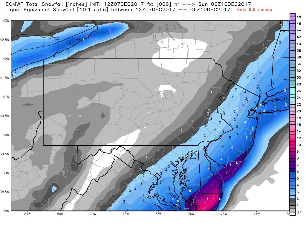
Yes it's five to ten inches. From the city on East even slightly west of the city is in on this I would say we're now starting to get a consensus that this will be our first snowfall of the year my best guess right now would be one to three inches for the city and nearby burbs and 3 to 6 South and East obviously the later in the day it fell on Saturday the better if it fell Saturday nightnutleyblizzard wrote:UKIE is west of 0z run.

algae888- Advanced Forecaster

- Posts : 5311
Reputation : 46
Join date : 2013-02-05
Age : 61
Location : mt. vernon, new york
Re: Possible Snowstorm December 8th-9th
![]() by nutleyblizzard Thu Dec 07, 2017 12:12 pm
by nutleyblizzard Thu Dec 07, 2017 12:12 pm
nutleyblizzard- Senior Enthusiast
- Posts : 1952
Reputation : 41
Join date : 2014-01-30
Age : 57
Location : Nutley, new jersey
Re: Possible Snowstorm December 8th-9th
![]() by algae888 Thu Dec 07, 2017 12:14 pm
by algae888 Thu Dec 07, 2017 12:14 pm
If we do get snow this would be a big fail by the Euro and GFS and the big win for the CMC and ukie. you can also add in the Navy and the JMA which have been all over this eventnutleyblizzard wrote:GEFS just came in west. Very good trends with the 12z suite.
algae888- Advanced Forecaster
- Posts : 5311
Reputation : 46
Join date : 2013-02-05
Age : 61
Location : mt. vernon, new york
Re: Possible Snowstorm December 8th-9th
![]() by algae888 Thu Dec 07, 2017 12:17 pm
by algae888 Thu Dec 07, 2017 12:17 pm
Yes .4lqe into the City and .5 at the Queens Nassau border they are wetter than the operational.nutleyblizzard wrote:GEFS just came in west. Very good trends with the 12z suite.
algae888- Advanced Forecaster
- Posts : 5311
Reputation : 46
Join date : 2013-02-05
Age : 61
Location : mt. vernon, new york
Re: Possible Snowstorm December 8th-9th
![]() by mikeypizano Thu Dec 07, 2017 12:19 pm
by mikeypizano Thu Dec 07, 2017 12:19 pm

mikeypizano- Pro Enthusiast
- Posts : 1118
Reputation : 66
Join date : 2017-01-05
Age : 35
Location : Wilkes-Barre/Scranton, PA
Re: Possible Snowstorm December 8th-9th
![]() by sroc4 Thu Dec 07, 2017 12:39 pm
by sroc4 Thu Dec 07, 2017 12:39 pm
skinsfan1177 wrote:sroc4 wrote:skinsfan1177 wrote:Hi res man looks great a lot of laten heat release. I mentioned that yesterday
Skins Im not sure what you mean by latent heat release?
Memory serves me correctly you can see it on the high-resolution nam model it has to do with the convection down to the South releasing Heat which pushes storms more North I remember reading this at one point somewhere on here
I dont recall that partcular convo, and Im not exactly sure how that would work in this particular set up. If you can find the discussion or if someone else can explain I would appreciate it. As far as I know the main determining factors are first at 500mb:
positioning of the N energy with respect to the Southern energy, and how focused or strung out is the S energy. Take a look at the differences between GFS vs CMC today at 12z.
Looking at the CMC first. If you go and look at the surface/precip maps youll notice there is zero precip that makes it into the area. The reason is this. N energy for the most part is steering the storm. That is its main role in this set up. On the CMC the timing of the S energy is such that it is actually slightly behind the N energy in the race to the coast. As a result the N energy actually deflects the energy OTS and keeps the trough orientation way too positive.
The GFS on the other hand you can clearly see the S energy is out ahead of the N energy. Keep in mind its the S energy that is creating the system, and the northern energy that is steering it. By being out ahead of the N energy the trough can go closer to neutral or only slightly positive as it reaches the coast which changes the steering flow more NE instead of ENE like the CMC shows. The N energy is actually very close to digging into the back side of the S energy on the GFS which would only further aid in tilting the trough neutral faster.
By changing the steering flow from ENE to a more NE direction you change the stregth and area of best Potential vorticity advection(PVA). PVA is the area out ahead of the main vort max in the 500mb maps that has the best veritical motion potential often the NW side of the developing LP. I wont go into any more detail on this for now.
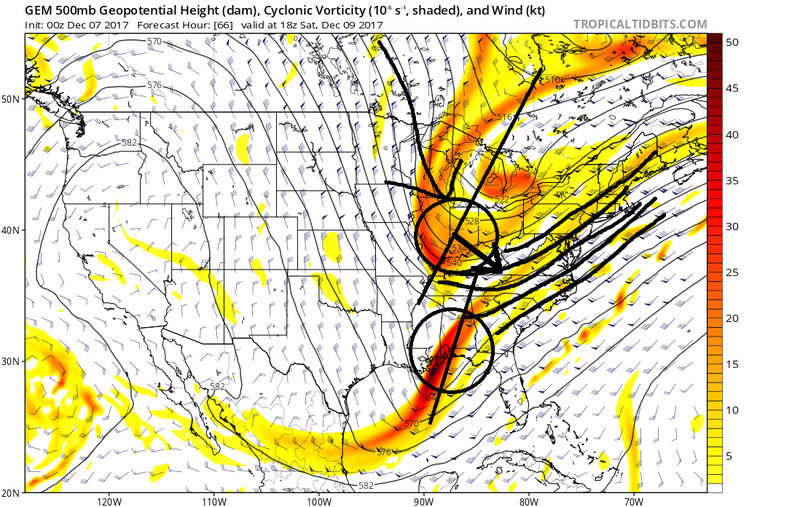
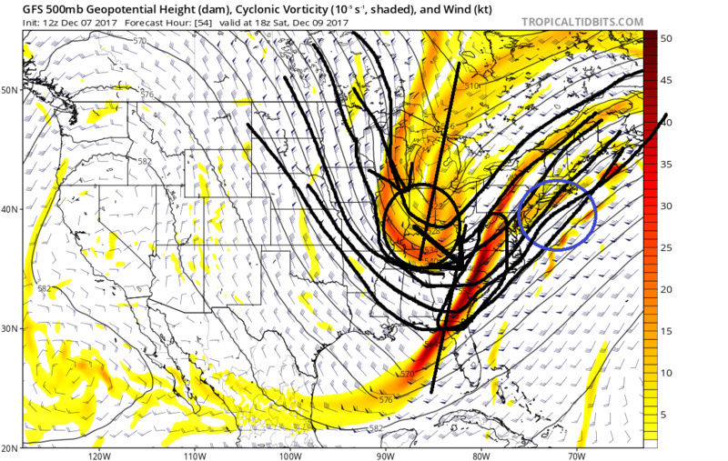
The second key factor in how far N&W the precip shield can expand is the position of the upper level jet streak. I dont have time for a detail explanaition but simply stated the Right rear quadrant of a jet streak is a favorable position for enhanced vertical motion from the lower levels. The reason is because the jet streak creates an upper level area of divergence created by the air racing away from slower moving air behind the jet streak. The air in the upper levels is replaced by air in the lower levels creating enhanced lift in the R rear quadrant of the jet streak. Vertical motion leads to condensation, and precipitation. More simply stated if the jet streak is too far S and E then our area falls out of the favorable R Rear quadrant and falls in an are of subsidence or sinking air. If its further N&W then we may fall in a more favorable area of convergence and the precip shield will expand further N&W accordingly. Here are the differences between the CMC and GFS.


These differences are subtle but are the reason for the difference in precip into the area of GFS vs no precip on CMC
_________________
"In weather and in life, there's no winning and losing; there's only winning and learning."
WINTER 2012/2013 TOTALS 43.65"WINTER 2017/2018 TOTALS 62.85" WINTER 2022/2023 TOTALS 4.9"
WINTER 2013/2014 TOTALS 64.85"WINTER 2018/2019 TOTALS 14.25" WINTER 2023/2024 TOTALS 13.1"
WINTER 2014/2015 TOTALS 71.20"WINTER 2019/2020 TOTALS 6.35"
WINTER 2015/2016 TOTALS 35.00"WINTER 2020/2021 TOTALS 37.75"
WINTER 2016/2017 TOTALS 42.25"WINTER 2021/2022 TOTALS 31.65"

sroc4- Admin

- Posts : 8331
Reputation : 301
Join date : 2013-01-07
Location : Wading River, LI
Re: Possible Snowstorm December 8th-9th
![]() by sroc4 Thu Dec 07, 2017 12:48 pm
by sroc4 Thu Dec 07, 2017 12:48 pm


_________________
"In weather and in life, there's no winning and losing; there's only winning and learning."
WINTER 2012/2013 TOTALS 43.65"WINTER 2017/2018 TOTALS 62.85" WINTER 2022/2023 TOTALS 4.9"
WINTER 2013/2014 TOTALS 64.85"WINTER 2018/2019 TOTALS 14.25" WINTER 2023/2024 TOTALS 13.1"
WINTER 2014/2015 TOTALS 71.20"WINTER 2019/2020 TOTALS 6.35"
WINTER 2015/2016 TOTALS 35.00"WINTER 2020/2021 TOTALS 37.75"
WINTER 2016/2017 TOTALS 42.25"WINTER 2021/2022 TOTALS 31.65"
sroc4- Admin
- Posts : 8331
Reputation : 301
Join date : 2013-01-07
Location : Wading River, LI
Re: Possible Snowstorm December 8th-9th
![]() by nutleyblizzard Thu Dec 07, 2017 12:57 pm
by nutleyblizzard Thu Dec 07, 2017 12:57 pm

nutleyblizzard- Senior Enthusiast
- Posts : 1952
Reputation : 41
Join date : 2014-01-30
Age : 57
Location : Nutley, new jersey
Re: Possible Snowstorm December 8th-9th
![]() by Frank_Wx Thu Dec 07, 2017 1:00 pm
by Frank_Wx Thu Dec 07, 2017 1:00 pm

_________________
_______________________________________________________________________________________________________
CLICK HERE to view NJ Strong Snowstorm Classifications

Frank_Wx- Godzilla Seeker
- Posts : 21305
Reputation : 328
Join date : 2013-01-05
Age : 31
Location : Jersey City, NJ -

Re: Possible Snowstorm December 8th-9th
![]() by Frank_Wx Thu Dec 07, 2017 1:01 pm
by Frank_Wx Thu Dec 07, 2017 1:01 pm

_________________
_______________________________________________________________________________________________________
CLICK HERE to view NJ Strong Snowstorm Classifications
Frank_Wx- Godzilla Seeker
- Posts : 21305
Reputation : 328
Join date : 2013-01-05
Age : 31
Location : Jersey City, NJ -
Re: Possible Snowstorm December 8th-9th
![]() by Frank_Wx Thu Dec 07, 2017 1:02 pm
by Frank_Wx Thu Dec 07, 2017 1:02 pm

_________________
_______________________________________________________________________________________________________
CLICK HERE to view NJ Strong Snowstorm Classifications
Frank_Wx- Godzilla Seeker
- Posts : 21305
Reputation : 328
Join date : 2013-01-05
Age : 31
Location : Jersey City, NJ -
Re: Possible Snowstorm December 8th-9th
![]() by Frank_Wx Thu Dec 07, 2017 1:04 pm
by Frank_Wx Thu Dec 07, 2017 1:04 pm
_________________
_______________________________________________________________________________________________________
CLICK HERE to view NJ Strong Snowstorm Classifications
Frank_Wx- Godzilla Seeker
- Posts : 21305
Reputation : 328
Join date : 2013-01-05
Age : 31
Location : Jersey City, NJ -
Re: Possible Snowstorm December 8th-9th
![]() by SENJsnowman Thu Dec 07, 2017 1:04 pm
by SENJsnowman Thu Dec 07, 2017 1:04 pm
SENJsnowman- Senior Enthusiast
- Posts : 1186
Reputation : 61
Join date : 2017-01-06
Age : 51
Location : Bayville, NJ
Re: Possible Snowstorm December 8th-9th
![]() by SoulSingMG Thu Dec 07, 2017 1:05 pm
by SoulSingMG Thu Dec 07, 2017 1:05 pm
https://www.accuweather.com/en/videos/snow-threat-increasing-for-mid-atlantic-and-northeast/9rnwjszde6cnohbua9msckvashyfoajo?SearchForm-input=snow%20threat%20increasing%20for%20mid-Atlantic%20and%20northeast

SoulSingMG- Senior Enthusiast
- Posts : 2853
Reputation : 74
Join date : 2013-12-11
Location : Long Island City, NY
Re: Possible Snowstorm December 8th-9th
![]() by Frank_Wx Thu Dec 07, 2017 1:06 pm
by Frank_Wx Thu Dec 07, 2017 1:06 pm
SENJsnowman wrote:NAVGEM also came back west. Is this looking like an all snow event right now? Could the storm come back 'too close' to the coast and cause p-type issues?
I'm thinking it will be mainly snow. May have to create a snowfall map :O
_________________
_______________________________________________________________________________________________________
CLICK HERE to view NJ Strong Snowstorm Classifications
Frank_Wx- Godzilla Seeker
- Posts : 21305
Reputation : 328
Join date : 2013-01-05
Age : 31
Location : Jersey City, NJ -
Re: Possible Snowstorm December 8th-9th
![]() by mikeypizano Thu Dec 07, 2017 1:09 pm
by mikeypizano Thu Dec 07, 2017 1:09 pm
SENJsnowman wrote:NAVGEM also came back west. Is this looking like an all snow event right now? Could the storm come back 'too close' to the coast and cause p-type issues?
Closer to coast means I get more snow...
mikeypizano- Pro Enthusiast
- Posts : 1118
Reputation : 66
Join date : 2017-01-05
Age : 35
Location : Wilkes-Barre/Scranton, PA
Re: Possible Snowstorm December 8th-9th
![]() by skinsfan1177 Thu Dec 07, 2017 1:17 pm
by skinsfan1177 Thu Dec 07, 2017 1:17 pm

skinsfan1177- Senior Enthusiast
- Posts : 4485
Reputation : 35
Join date : 2013-01-07
Age : 46
Location : Point Pleasant Boro
Re: Possible Snowstorm December 8th-9th
![]() by jmanley32 Thu Dec 07, 2017 1:27 pm
by jmanley32 Thu Dec 07, 2017 1:27 pm

jmanley32- Senior Enthusiast
- Posts : 20512
Reputation : 108
Join date : 2013-12-12
Age : 42
Location : Yonkers, NY
Re: Possible Snowstorm December 8th-9th
![]() by jmanley32 Thu Dec 07, 2017 1:29 pm
by jmanley32 Thu Dec 07, 2017 1:29 pm
Waiting for those madonnes Frank lol, prolly won't get with this one but glad to see you back around, would love to see a snow map.Frank_Wx wrote:SENJsnowman wrote:NAVGEM also came back west. Is this looking like an all snow event right now? Could the storm come back 'too close' to the coast and cause p-type issues?
I'm thinking it will be mainly snow. May have to create a snowfall map :O
jmanley32- Senior Enthusiast
- Posts : 20512
Reputation : 108
Join date : 2013-12-12
Age : 42
Location : Yonkers, NY
Re: Possible Snowstorm December 8th-9th
![]() by sroc4 Thu Dec 07, 2017 1:32 pm
by sroc4 Thu Dec 07, 2017 1:32 pm

_________________
"In weather and in life, there's no winning and losing; there's only winning and learning."
WINTER 2012/2013 TOTALS 43.65"WINTER 2017/2018 TOTALS 62.85" WINTER 2022/2023 TOTALS 4.9"
WINTER 2013/2014 TOTALS 64.85"WINTER 2018/2019 TOTALS 14.25" WINTER 2023/2024 TOTALS 13.1"
WINTER 2014/2015 TOTALS 71.20"WINTER 2019/2020 TOTALS 6.35"
WINTER 2015/2016 TOTALS 35.00"WINTER 2020/2021 TOTALS 37.75"
WINTER 2016/2017 TOTALS 42.25"WINTER 2021/2022 TOTALS 31.65"
sroc4- Admin
- Posts : 8331
Reputation : 301
Join date : 2013-01-07
Location : Wading River, LI
Re: Possible Snowstorm December 8th-9th
![]() by jmanley32 Thu Dec 07, 2017 1:42 pm
by jmanley32 Thu Dec 07, 2017 1:42 pm
jmanley32- Senior Enthusiast
- Posts : 20512
Reputation : 108
Join date : 2013-12-12
Age : 42
Location : Yonkers, NY
mikeypizano- Pro Enthusiast
- Posts : 1118
Reputation : 66
Join date : 2017-01-05
Age : 35
Location : Wilkes-Barre/Scranton, PA
Re: Possible Snowstorm December 8th-9th
![]() by algae888 Thu Dec 07, 2017 1:48 pm
by algae888 Thu Dec 07, 2017 1:48 pm
algae888- Advanced Forecaster
- Posts : 5311
Reputation : 46
Join date : 2013-02-05
Age : 61
Location : mt. vernon, new york
Page 8 of 15 • 1 ... 5 ... 7, 8, 9 ... 11 ... 15 ![]()
|
|
|