
 Search
Long Range Thread 15.0
Page 1 of 42 • 1, 2, 3 ... 21 ... 42 ![]()

Long Range Thread 15.0
![]() by Frank_Wx Wed Sep 20, 2017 1:33 pm
by Frank_Wx Wed Sep 20, 2017 1:33 pm

In the last 7 days, sea surface temperatures in the eastern Equatorial Pacific have dramatically cooled. The dark shades of blue you see there are indicative of that. While ENSO forecasts show a clear La Nina developing, we're seeing it happen real-time on SSTA (sea surface temperature anomaly) maps.
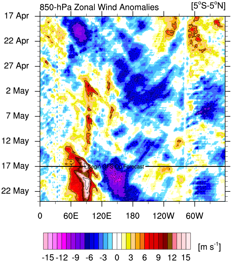
We're observing and are expected to continue observing anomalous easterly mean zonal winds (blue shading) from the Indian Ocean and points east. This 'cold' episode is indicative of La Nina conditions continuing to take shape as we head through Meteorological Fall. At present time, La Nina seems to be east-based. Over time, perhaps by winter, I can see La Nina be fairly spread out through the entire Equatorial Pacific. Easterly winds east of the Dateline are forecasted to weaken by October. However, they're expected to strengthen over or west of the Dateline.

A pretty dramatic decrease of SST's over ENSO Region 3.4 over the Summer months.


If anyone is looking for when our next taste of Fall weather arrives, the EPS and GEFS are in agreement we may see a period of below normal temperatures commencing near September 30th through the first few days of October.
Let's take a vote on who the first member will be to post a fantasy model run showing a Godzilla impacting our area. To be clear, I prefer those be posted in the Banter thread but I will not be upset if a few are posted in this thread
_________________
_______________________________________________________________________________________________________
CLICK HERE to view NJ Strong Snowstorm Classifications

Frank_Wx- Godzilla Seeker

- Posts : 21305
Reputation : 328
Join date : 2013-01-05
Age : 31
Location : Jersey City, NJ -

Re: Long Range Thread 15.0
![]() by billg315 Wed Sep 20, 2017 9:29 pm
by billg315 Wed Sep 20, 2017 9:29 pm

billg315- Advanced Forecaster - Mod

- Posts : 4462
Reputation : 185
Join date : 2015-01-24
Age : 50
Location : Flemington, NJ
Re: Long Range Thread 15.0
![]() by billg315 Wed Sep 20, 2017 9:31 pm
by billg315 Wed Sep 20, 2017 9:31 pm
billg315- Advanced Forecaster - Mod
- Posts : 4462
Reputation : 185
Join date : 2015-01-24
Age : 50
Location : Flemington, NJ
Re: Long Range Thread 15.0
![]() by RJB8525 Wed Sep 20, 2017 9:57 pm
by RJB8525 Wed Sep 20, 2017 9:57 pm

RJB8525- Senior Enthusiast

- Posts : 1994
Reputation : 28
Join date : 2013-02-06
Age : 38
Location : Hackettstown, NJ
Re: Long Range Thread 15.0
![]() by amugs Thu Sep 21, 2017 12:04 am
by amugs Thu Sep 21, 2017 12:04 am
I will take an East bases nine with an Easterly QBO and a positive PDO and roll with it.
_________________
Mugs
AKA:King: Snow Weenie
Self Proclaimed
WINTER 2014-15 : 55.12" +.02 for 6 coatings (avg. 35")
WINTER 2015-16 Total - 29.8" (Avg 35")
WINTER 2016-17 : 39.5" so far

amugs- Advanced Forecaster - Mod
- Posts : 15093
Reputation : 213
Join date : 2013-01-07
Age : 54
Location : Hillsdale,NJ
Re: Long Range Thread 15.0
![]() by RJB8525 Thu Sep 21, 2017 9:29 am
by RJB8525 Thu Sep 21, 2017 9:29 am
amugs wrote:LOL RJB.!!!
I will take an East bases nine with an Easterly QBO and a positive PDO and roll with it.
RJB8525- Senior Enthusiast
- Posts : 1994
Reputation : 28
Join date : 2013-02-06
Age : 38
Location : Hackettstown, NJ
Re: Long Range Thread 15.0
![]() by amugs Thu Sep 21, 2017 10:44 am
by amugs Thu Sep 21, 2017 10:44 am
RJB8525 wrote:amugs wrote:LOL RJB.!!!
I will take an East bases nine with an Easterly QBO and a positive PDO and roll with it.

Thanks RJB.
_________________
Mugs
AKA:King: Snow Weenie
Self Proclaimed
WINTER 2014-15 : 55.12" +.02 for 6 coatings (avg. 35")
WINTER 2015-16 Total - 29.8" (Avg 35")
WINTER 2016-17 : 39.5" so far
amugs- Advanced Forecaster - Mod
- Posts : 15093
Reputation : 213
Join date : 2013-01-07
Age : 54
Location : Hillsdale,NJ
Re: Long Range Thread 15.0
![]() by amugs Thu Sep 21, 2017 5:29 pm
by amugs Thu Sep 21, 2017 5:29 pm
_________________
Mugs
AKA:King: Snow Weenie
Self Proclaimed
WINTER 2014-15 : 55.12" +.02 for 6 coatings (avg. 35")
WINTER 2015-16 Total - 29.8" (Avg 35")
WINTER 2016-17 : 39.5" so far
amugs- Advanced Forecaster - Mod
- Posts : 15093
Reputation : 213
Join date : 2013-01-07
Age : 54
Location : Hillsdale,NJ
Re: Long Range Thread 15.0
![]() by amugs Fri Sep 22, 2017 10:18 am
by amugs Fri Sep 22, 2017 10:18 am
_________________
Mugs
AKA:King: Snow Weenie
Self Proclaimed
WINTER 2014-15 : 55.12" +.02 for 6 coatings (avg. 35")
WINTER 2015-16 Total - 29.8" (Avg 35")
WINTER 2016-17 : 39.5" so far
amugs- Advanced Forecaster - Mod
- Posts : 15093
Reputation : 213
Join date : 2013-01-07
Age : 54
Location : Hillsdale,NJ
Re: Long Range Thread 15.0
![]() by nutleyblizzard Fri Sep 22, 2017 10:36 am
by nutleyblizzard Fri Sep 22, 2017 10:36 am
The only way to fend off a moderate/strong Nina is with sustained Atlantic blocking in place.Without one, the SE ridge takes over and we torch. The problem is the past several winters we've had sporadic blocking at best. Its a shame the pattern we're in now isn't happening in January. I'm with you Mugs we need this Nina to stay weak.amugs wrote:Weak Nina coming in for winter and hopefully the CFSv2 is wrong cause a mod Nina will kill winter!!


nutleyblizzard- Senior Enthusiast
- Posts : 1952
Reputation : 41
Join date : 2014-01-30
Age : 58
Location : Nutley, new jersey
Re: Long Range Thread 15.0
![]() by sroc4 Fri Sep 22, 2017 11:22 am
by sroc4 Fri Sep 22, 2017 11:22 am
Like has been mentioned a weak to weak/mod La Nina is what we need to hope for. The stronger it is the more robust the SE ridge will be and the more difficult it will be for other more favorable conditions to counteract the negative ones. Strat warming events for example will become that much more important in the winter months to beat back the SE ridge by compressing the tropospheric heights over NA assuming the strat warming is strong enough, and positioned in the right place of the N hemisphere. Interesting times ahead. I am starting to see what Tom (Isotherm) may be alluding to and that is a rogue mod to strong La Nina. Sub surface temps cont to be robustly below normal in the Trop Pac.
_________________
"In weather and in life, there's no winning and losing; there's only winning and learning."
WINTER 2012/2013 TOTALS 43.65"WINTER 2017/2018 TOTALS 62.85" WINTER 2022/2023 TOTALS 4.9"
WINTER 2013/2014 TOTALS 64.85"WINTER 2018/2019 TOTALS 14.25" WINTER 2023/2024 TOTALS 13.1"
WINTER 2014/2015 TOTALS 71.20"WINTER 2019/2020 TOTALS 6.35"
WINTER 2015/2016 TOTALS 35.00"WINTER 2020/2021 TOTALS 37.75"
WINTER 2016/2017 TOTALS 42.25"WINTER 2021/2022 TOTALS 31.65"

sroc4- Admin
- Posts : 8331
Reputation : 301
Join date : 2013-01-07
Location : Wading River, LI
Re: Long Range Thread 15.0
![]() by sroc4 Mon Sep 25, 2017 10:56 am
by sroc4 Mon Sep 25, 2017 10:56 am

_________________
"In weather and in life, there's no winning and losing; there's only winning and learning."
WINTER 2012/2013 TOTALS 43.65"WINTER 2017/2018 TOTALS 62.85" WINTER 2022/2023 TOTALS 4.9"
WINTER 2013/2014 TOTALS 64.85"WINTER 2018/2019 TOTALS 14.25" WINTER 2023/2024 TOTALS 13.1"
WINTER 2014/2015 TOTALS 71.20"WINTER 2019/2020 TOTALS 6.35"
WINTER 2015/2016 TOTALS 35.00"WINTER 2020/2021 TOTALS 37.75"
WINTER 2016/2017 TOTALS 42.25"WINTER 2021/2022 TOTALS 31.65"
sroc4- Admin
- Posts : 8331
Reputation : 301
Join date : 2013-01-07
Location : Wading River, LI
Re: Long Range Thread 15.0
![]() by amugs Mon Sep 25, 2017 11:00 am
by amugs Mon Sep 25, 2017 11:00 am
http://www.cnn.com/2017/09/25/asia/indonesia-bali-mount-agung/
_________________
Mugs
AKA:King: Snow Weenie
Self Proclaimed
WINTER 2014-15 : 55.12" +.02 for 6 coatings (avg. 35")
WINTER 2015-16 Total - 29.8" (Avg 35")
WINTER 2016-17 : 39.5" so far
amugs- Advanced Forecaster - Mod
- Posts : 15093
Reputation : 213
Join date : 2013-01-07
Age : 54
Location : Hillsdale,NJ
Re: Long Range Thread 15.0
![]() by weatherwatchermom Mon Sep 25, 2017 11:12 am
by weatherwatchermom Mon Sep 25, 2017 11:12 am
amugs wrote:This could be a BIGGIE to winter if she blows NOW and gets her ash and particle into the stratosphere. The ring of fire is boiling now.
http://www.cnn.com/2017/09/25/asia/indonesia-bali-mount-agung/
that would create a cooling effect, correct?

weatherwatchermom- Senior Enthusiast
- Posts : 3733
Reputation : 77
Join date : 2014-11-25
Age : 60
Location : Hazlet Township, NJ
Re: Long Range Thread 15.0
![]() by sroc4 Mon Sep 25, 2017 12:49 pm
by sroc4 Mon Sep 25, 2017 12:49 pm
weatherwatchermom wrote:amugs wrote:This could be a BIGGIE to winter if she blows NOW and gets her ash and particle into the stratosphere. The ring of fire is boiling now.
http://www.cnn.com/2017/09/25/asia/indonesia-bali-mount-agung/
that would create a cooling effect, correct?
Possibly.
_________________
"In weather and in life, there's no winning and losing; there's only winning and learning."
WINTER 2012/2013 TOTALS 43.65"WINTER 2017/2018 TOTALS 62.85" WINTER 2022/2023 TOTALS 4.9"
WINTER 2013/2014 TOTALS 64.85"WINTER 2018/2019 TOTALS 14.25" WINTER 2023/2024 TOTALS 13.1"
WINTER 2014/2015 TOTALS 71.20"WINTER 2019/2020 TOTALS 6.35"
WINTER 2015/2016 TOTALS 35.00"WINTER 2020/2021 TOTALS 37.75"
WINTER 2016/2017 TOTALS 42.25"WINTER 2021/2022 TOTALS 31.65"
sroc4- Admin
- Posts : 8331
Reputation : 301
Join date : 2013-01-07
Location : Wading River, LI
Re: Long Range Thread 15.0
![]() by Isotherm Mon Sep 25, 2017 2:06 pm
by Isotherm Mon Sep 25, 2017 2:06 pm
Isotherm- Advanced Forecaster

- Posts : 231
Reputation : 4
Join date : 2014-09-01
Age : 33
Location : Monmouth County, NJ -
Re: Long Range Thread 15.0
![]() by amugs Mon Sep 25, 2017 9:52 pm
by amugs Mon Sep 25, 2017 9:52 pm
Isotherm wrote:I am watching Agungo closely. If it looks like we're going to see a VEI 5+ eruption, there is quite a bit of research out there regarding the atmospheric modulatory effects tropospherically, stratospherically, worldwide. What's interesting as well is that the previous major tropical volcanic eruptions occurred in El Nino events - 1963 Agungo, as moderate el nino initiated; 1982 El Chichon - as strong el nino began; and 1991 Pinatubo - as strong el nino initiated. The respective ENSO states countervailed the year 1 cooling induced by those volcanoes (delay to year 2) such that net was near zero. However, this could be a unique situation in which we see a major eruption coincident with a developing weak to moderate La Nina. Those mechanisms would act adjunctively / cumulatively as far as cooling effects induced globally, possibly yielding an even stronger cooling signal. Of course, there are a lot of IFs here, including La Nina intensity, VEI, evolution of the event, does it occur, etc.
Awesome post and I was reading an article about as we have talked about before Tim that corelation between low.solar and seismic high activity - eq and volcanoes. It would be something to see anologies if we have any for a nina and such a massive expoison if one were to be.
_________________
Mugs
AKA:King: Snow Weenie
Self Proclaimed
WINTER 2014-15 : 55.12" +.02 for 6 coatings (avg. 35")
WINTER 2015-16 Total - 29.8" (Avg 35")
WINTER 2016-17 : 39.5" so far
amugs- Advanced Forecaster - Mod
- Posts : 15093
Reputation : 213
Join date : 2013-01-07
Age : 54
Location : Hillsdale,NJ
Re: Long Range Thread 15.0
![]() by Frank_Wx Tue Sep 26, 2017 8:11 am
by Frank_Wx Tue Sep 26, 2017 8:11 am
_________________
_______________________________________________________________________________________________________
CLICK HERE to view NJ Strong Snowstorm Classifications
Frank_Wx- Godzilla Seeker
- Posts : 21305
Reputation : 328
Join date : 2013-01-05
Age : 31
Location : Jersey City, NJ -
Re: Long Range Thread 15.0
![]() by amugs Tue Sep 26, 2017 9:19 am
by amugs Tue Sep 26, 2017 9:19 am
Frank_Wx wrote:It appears the break in temps this weekend will be temporary. The GFS and GEFS show a ridge returning to our area next week. Man, what a mild fall to this point!
Reason being - strong PAC JET extension forming - WTH with the Nina base state of the PAC we have one of these - this was the culprit last winter as well!
_________________
Mugs
AKA:King: Snow Weenie
Self Proclaimed
WINTER 2014-15 : 55.12" +.02 for 6 coatings (avg. 35")
WINTER 2015-16 Total - 29.8" (Avg 35")
WINTER 2016-17 : 39.5" so far
amugs- Advanced Forecaster - Mod
- Posts : 15093
Reputation : 213
Join date : 2013-01-07
Age : 54
Location : Hillsdale,NJ
Re: Long Range Thread 15.0
![]() by sroc4 Tue Sep 26, 2017 11:57 am
by sroc4 Tue Sep 26, 2017 11:57 am
amugs wrote:Frank_Wx wrote:It appears the break in temps this weekend will be temporary. The GFS and GEFS show a ridge returning to our area next week. Man, what a mild fall to this point!
Reason being - strong PAC JET extension forming - WTH with the Nina base state of the PAC we have one of these - this was the culprit last winter as well!
Mugsy where are you getting the idea of a jet extension? I'm not really seeing it in any of the modeling. Nothing consistent anyway. In response to re-curving Maria we will get a transient amplification of the pattern over NA which will bring back fall like temps for late week and the weekend into the heart land and EC, but I think we simply have a base state in a La Nina type pattern setting up for the fall where we get a ridge in the east and trough in the west. SOI has been very consistent in the La Nina territory with very transient trips towards neutral or negative. The MJO has been pretty much a non factor in the COD. Yet again we have the GFS showing amplification, into strong phase 8, which if correct would also promote warmer temp anomalies. That said pretty much any time the GFS showed an MJO amplification out of the COD over the past few months it has not come to fruition.

The Euro as you can see says what amplification?

It looks like after we move past the next week or so and the pattern relaxes some relative to the trop system influences the ensembles are hinting at the troughyness in the west and ridging in the east which is very La nina like. But don't fret just yet as the wavelengths change as we head deeper into the colder months so the atmosphere's response to the same conditions in say Jan/Feb may be quite different meaning the trough and ridge axis would be in different positions.
_________________
"In weather and in life, there's no winning and losing; there's only winning and learning."
WINTER 2012/2013 TOTALS 43.65"WINTER 2017/2018 TOTALS 62.85" WINTER 2022/2023 TOTALS 4.9"
WINTER 2013/2014 TOTALS 64.85"WINTER 2018/2019 TOTALS 14.25" WINTER 2023/2024 TOTALS 13.1"
WINTER 2014/2015 TOTALS 71.20"WINTER 2019/2020 TOTALS 6.35"
WINTER 2015/2016 TOTALS 35.00"WINTER 2020/2021 TOTALS 37.75"
WINTER 2016/2017 TOTALS 42.25"WINTER 2021/2022 TOTALS 31.65"
sroc4- Admin
- Posts : 8331
Reputation : 301
Join date : 2013-01-07
Location : Wading River, LI
Re: Long Range Thread 15.0
![]() by dkodgis Tue Sep 26, 2017 12:31 pm
by dkodgis Tue Sep 26, 2017 12:31 pm

dkodgis- Senior Enthusiast
- Posts : 2493
Reputation : 98
Join date : 2013-12-29
Re: Long Range Thread 15.0
![]() by amugs Wed Sep 27, 2017 10:22 am
by amugs Wed Sep 27, 2017 10:22 am
amugs wrote:Frank_Wx wrote:It appears the break in temps this weekend will be temporary. The GFS and GEFS show a ridge returning to our area next week. Man, what a mild fall to this point!
Reason being - strong PAC JET extension forming - WTH with the Nina base state of the PAC we have one of these - this was the culprit last winter as well!
Scott here is the link I saw on Twitter from Ben Noll showing the PAC Jet roaaring - curse you!!!!
https://twitter.com/BenNollWeather/status/912313502865518592
_________________
Mugs
AKA:King: Snow Weenie
Self Proclaimed
WINTER 2014-15 : 55.12" +.02 for 6 coatings (avg. 35")
WINTER 2015-16 Total - 29.8" (Avg 35")
WINTER 2016-17 : 39.5" so far
amugs- Advanced Forecaster - Mod
- Posts : 15093
Reputation : 213
Join date : 2013-01-07
Age : 54
Location : Hillsdale,NJ
Re: Long Range Thread 15.0
![]() by sroc4 Wed Sep 27, 2017 12:25 pm
by sroc4 Wed Sep 27, 2017 12:25 pm
amugs wrote:amugs wrote:Frank_Wx wrote:It appears the break in temps this weekend will be temporary. The GFS and GEFS show a ridge returning to our area next week. Man, what a mild fall to this point!
Reason being - strong PAC JET extension forming - WTH with the Nina base state of the PAC we have one of these - this was the culprit last winter as well!
Scott here is the link I saw on Twitter from Ben Noll showing the PAC Jet roaaring - curse you!!!!
https://twitter.com/BenNollWeather/status/912313502865518592
Well the good news, if there is any good news about above normal temps, is that it may not be quite as bad as we think at least for our neck of the woods. Ill try and explain in the other thread where you posted what at first glance appears to be a death ridge, but the positioning of the ridge isnt horrible relative to the ridging in the Atlantic. The hot and humid days we have had over the last couple of weeks have been compliments of our tropical systems; however, the set up is shifting a little. Yes we still have the Nina base state and ridge east/trough west, but look at the wind directions at 500mb. Where does our air come from? More to come.
Plus if you look at the GFS and Euro modeling both show these jet extensions as transient and fluid over the N Pac. All sorts of bends and kinks that seems to rinse wash and repeat themselves over the eastern half of the N Pac. What that guy shows on twitter is the JMA two week avgs for weeks 1&2 and 3&4. As we transition deeper into fall the temp gradients from N to S are starting to enhance the polar jet streams so seasonal changes combined with our La Nina base state and no other big picture drivers right now I think alot of transient rinse wash repeat type of a weather pattern is likely for some time. Above normal temps out ahead of a front that pushes through and gives us normal to slight below normal temps briefly then back again. As log as the ridge stays centered over the Mid west humidity hopefully wont be too bad.
_________________
"In weather and in life, there's no winning and losing; there's only winning and learning."
WINTER 2012/2013 TOTALS 43.65"WINTER 2017/2018 TOTALS 62.85" WINTER 2022/2023 TOTALS 4.9"
WINTER 2013/2014 TOTALS 64.85"WINTER 2018/2019 TOTALS 14.25" WINTER 2023/2024 TOTALS 13.1"
WINTER 2014/2015 TOTALS 71.20"WINTER 2019/2020 TOTALS 6.35"
WINTER 2015/2016 TOTALS 35.00"WINTER 2020/2021 TOTALS 37.75"
WINTER 2016/2017 TOTALS 42.25"WINTER 2021/2022 TOTALS 31.65"
sroc4- Admin
- Posts : 8331
Reputation : 301
Join date : 2013-01-07
Location : Wading River, LI
Re: Long Range Thread 15.0
![]() by amugs Wed Sep 27, 2017 2:10 pm
by amugs Wed Sep 27, 2017 2:10 pm
_________________
Mugs
AKA:King: Snow Weenie
Self Proclaimed
WINTER 2014-15 : 55.12" +.02 for 6 coatings (avg. 35")
WINTER 2015-16 Total - 29.8" (Avg 35")
WINTER 2016-17 : 39.5" so far
amugs- Advanced Forecaster - Mod
- Posts : 15093
Reputation : 213
Join date : 2013-01-07
Age : 54
Location : Hillsdale,NJ
Re: Long Range Thread 15.0
![]() by Isotherm Thu Sep 28, 2017 11:02 pm
by Isotherm Thu Sep 28, 2017 11:02 pm
amugs wrote:Isotherm wrote:I am watching Agungo closely. If it looks like we're going to see a VEI 5+ eruption, there is quite a bit of research out there regarding the atmospheric modulatory effects tropospherically, stratospherically, worldwide. What's interesting as well is that the previous major tropical volcanic eruptions occurred in El Nino events - 1963 Agungo, as moderate el nino initiated; 1982 El Chichon - as strong el nino began; and 1991 Pinatubo - as strong el nino initiated. The respective ENSO states countervailed the year 1 cooling induced by those volcanoes (delay to year 2) such that net was near zero. However, this could be a unique situation in which we see a major eruption coincident with a developing weak to moderate La Nina. Those mechanisms would act adjunctively / cumulatively as far as cooling effects induced globally, possibly yielding an even stronger cooling signal. Of course, there are a lot of IFs here, including La Nina intensity, VEI, evolution of the event, does it occur, etc.
Awesome post and I was reading an article about as we have talked about before Tim that corelation between low.solar and seismic high activity - eq and volcanoes. It would be something to see anologies if we have any for a nina and such a massive expoison if one were to be.
Thank you mugs, and agreed it would be very fascinating to watch this unfold. The meteorology/weather enthusiast community has never experienced a VEI 5+ tropical volcanic eruption with today's technology / internet, etc. Would be fun to track the impending modulation of weather on a micro and macro scale.
Isotherm- Advanced Forecaster
- Posts : 231
Reputation : 4
Join date : 2014-09-01
Age : 33
Location : Monmouth County, NJ -
Page 1 of 42 • 1, 2, 3 ... 21 ... 42 ![]()
|
|
|