
 Search
Long Range Thread 16.0
Page 32 of 40 •  1 ... 17 ... 31, 32, 33 ... 36 ... 40
 ![]()
Re: Long Range Thread 16.0
![]() by GreyBeard Tue Jan 23, 2018 12:23 pm
by GreyBeard Tue Jan 23, 2018 12:23 pm
GreyBeard- Senior Enthusiast

- Posts : 725
Join date : 2014-02-12
Re: Long Range Thread 16.0
![]() by CPcantmeasuresnow Tue Jan 23, 2018 12:33 pm
by CPcantmeasuresnow Tue Jan 23, 2018 12:33 pm
Snow88 wrote:Models are starting to show the 29-30th storm again, especially for the interior. CMC and Icon are forming another wave after the rainstorm.
They develop a coastal
There is always some kind of optimism in a snow88 post. A 180° difference from the typical math 23×7 post. Personally I'd rather see a last post by snow88, Mikey has gone way too dark.
CPcantmeasuresnow- Wx Statistician Guru

- Posts : 7274
Join date : 2013-01-07
Re: Long Range Thread 16.0
![]() by Snow88 Tue Jan 23, 2018 12:35 pm
by Snow88 Tue Jan 23, 2018 12:35 pm
CPcantmeasuresnow wrote:Snow88 wrote:Models are starting to show the 29-30th storm again, especially for the interior. CMC and Icon are forming another wave after the rainstorm.
They develop a coastal
There is always some kind of optimism in a snow88 post. A 180° difference from the typical math 23×7 post. Personally I'd rather see a last post by snow88, Mikey has gone way too dark.
Just posting what the models show
I don't see Mikey posting alot anymore

Snow88- Senior Enthusiast
- Posts : 2193
Reputation : 4
Join date : 2013-01-09
Age : 35
Location : Brooklyn, NY
Re: Long Range Thread 16.0
![]() by amugs Tue Jan 23, 2018 1:04 pm
by amugs Tue Jan 23, 2018 1:04 pm
 .png" alt="" />
https://www.weatherbell.com/images/imguploader/images/eps_qpf_168h_ausnz_4(6).png
.png)
This will take teh MJO out of the warm phases as convection dies down and allow this wave to propagate east into the colder phases.
I have said before East based Nina
1.2 colder than 3.4
1.2

3.4

We have a WWB in the making and majorly to a degree this winter
WWB = Westerly Wind Burst which will blow the warm waters into the 3.4
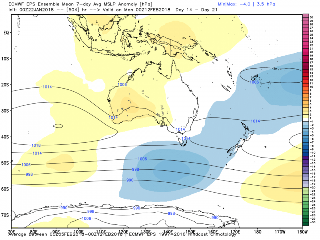
So these warmer waters off the Australian coast and 180 dateline go easterly.
It looks to be setting us up for a very good run in February through early/misih March.
If we can get something as I showed the other day on the 29-30th then that is just gravy in a warm period, AN overall. I dont think the coast sees anything but the interior does to a degree
Very positive signs for the winter weenies here peeps and for Frank to give a post as positive as he did says something!
N EPO press will low level cold air get in here faster than some think due to the freezer over head in Canada, like my call date teh 5thish - that maybe too late if models are correct.
_________________
Mugs
AKA:King: Snow Weenie
Self Proclaimed
WINTER 2014-15 : 55.12" +.02 for 6 coatings (avg. 35")
WINTER 2015-16 Total - 29.8" (Avg 35")
WINTER 2016-17 : 39.5" so far

amugs- Advanced Forecaster - Mod

- Posts : 15091
Reputation : 213
Join date : 2013-01-07
Age : 54
Location : Hillsdale,NJ
Re: Long Range Thread 16.0
![]() by algae888 Tue Jan 23, 2018 1:34 pm
by algae888 Tue Jan 23, 2018 1:34 pm
Euro on board to all major models have system for next Monday too early to tell precip types but definitely trending colderSnow88 wrote:CPcantmeasuresnow wrote:Snow88 wrote:Models are starting to show the 29-30th storm again, especially for the interior. CMC and Icon are forming another wave after the rainstorm.
They develop a coastal
There is always some kind of optimism in a snow88 post. A 180° difference from the typical math 23×7 post. Personally I'd rather see a last post by snow88, Mikey has gone way too dark.
Just posting what the models show
I don't see Mikey posting alot anymore

algae888- Advanced Forecaster

- Posts : 5311
Reputation : 46
Join date : 2013-02-05
Age : 61
Location : mt. vernon, new york
Re: Long Range Thread 16.0
![]() by amugs Tue Jan 23, 2018 8:56 pm
by amugs Tue Jan 23, 2018 8:56 pm

BAMMMM!! The flood gates open!
.gif)
_________________
Mugs
AKA:King: Snow Weenie
Self Proclaimed
WINTER 2014-15 : 55.12" +.02 for 6 coatings (avg. 35")
WINTER 2015-16 Total - 29.8" (Avg 35")
WINTER 2016-17 : 39.5" so far
amugs- Advanced Forecaster - Mod
- Posts : 15091
Reputation : 213
Join date : 2013-01-07
Age : 54
Location : Hillsdale,NJ
Re: Long Range Thread 16.0
![]() by Math23x7 Wed Jan 24, 2018 12:54 am
by Math23x7 Wed Jan 24, 2018 12:54 am
The one problem is that these two features are a bit further west than I would like them to be. But this would be a step in the right direction. This should be the beginning of the transition in the upper atmosphere back to what we would like. I mentioned before that President's Day is when I expect the big snow chances to resume. I stand by that premise.
Math23x7- Wx Statistician Guru
- Posts : 2379
Reputation : 68
Join date : 2013-01-08
Re: Long Range Thread 16.0
![]() by sroc4 Wed Jan 24, 2018 7:18 am
by sroc4 Wed Jan 24, 2018 7:18 am
sroc4 wrote:
Again with a strong -WPO by day 7 or so AND a -AO, 2-3days later we may see a piece of energy release from the west coast as hopefully a transient ridge in the PNA and/or EPO region occurs in response to the -WPO/-AO block. IF this happens the "possibility" of a Canadian HP dropping far enough south such that this energy comes underneath towards the EC having a cold air source to tap into. Remember this is a long way off in a pattern that is not overtly conducive to a storm, but there are ways for it to happen. This has been proven over the last two winters. It would have to be the preverbal the pieces have to come together "just right" scenario so for now odds are certainly against this from happening, BUT....for now at least its something to monitor. Update on the evolution of the ensemble forecast in a few days.
GEFS:
EPS:

Good morning folks. First Recall this discussion from Dec 19th regarding the potential for Jan 27th-30th. As of this morning it still looks like this will not materialize as the flow still looks too progressive. In order for this to work we MUST see the ridge in the west cont to trend stronger. As of this morning it just isn't strong enough to drive a northern piece of energy deep enough over the heart of the CONUS to either A) interact with or phase with southern energy to tilt the mean trough enough neutral or neg to develop a stronger system that has a chance to tap into colder air and come more N than E as is currently progged by most major models. or B) have enough wave spacing between the southern energy passing first allowing the polar frontal boundary to drop south of us then a Northern s/w dig enough on its own to develop along the old frontal boundary; tapping into the Atlantic as it reaches the coast.


Again the odds are def against this happening as of this morning, but there is still a window of time to see some addition trends. As of this morning if you look at the surface maps you ll notice no coastal, but rather a line of precip strung out along a frontal boundary harmlessly pass us by and warm sectored when precip passes. But at 500mb the western ridge has slowly been trending a tad stronger with time within all modeling. Here is the GFS 500mb trend map. Notice the Reds in the NW and the Blues in the heart of the country. This map indicates thathe GFS model has been trending stronger with higher heights where the reds are and stronger with lower heights where the blues are. Again as of now its not enough to make this happen but there is still enough time for additional trends to become more favorable for "something". If this were to com together this would heavily favor a N&W frozen event. The coastal plain will not likely benefit from this system.

_________________
"In weather and in life, there's no winning and losing; there's only winning and learning."
WINTER 2012/2013 TOTALS 43.65"WINTER 2017/2018 TOTALS 62.85" WINTER 2022/2023 TOTALS 4.9"
WINTER 2013/2014 TOTALS 64.85"WINTER 2018/2019 TOTALS 14.25" WINTER 2023/2024 TOTALS 13.1"
WINTER 2014/2015 TOTALS 71.20"WINTER 2019/2020 TOTALS 6.35"
WINTER 2015/2016 TOTALS 35.00"WINTER 2020/2021 TOTALS 37.75"
WINTER 2016/2017 TOTALS 42.25"WINTER 2021/2022 TOTALS 31.65"

sroc4- Admin

- Posts : 8331
Reputation : 301
Join date : 2013-01-07
Location : Wading River, LI
Re: Long Range Thread 16.0
![]() by sroc4 Wed Jan 24, 2018 9:18 am
by sroc4 Wed Jan 24, 2018 9:18 am
Update on the 27th-30th time frame coming early this week.

quote]
Second: Regarding the pattern flip in the first week of Feb. Recall the above discussion regarding our pattern shift back to a more favorable one for consistent cold and snow around the 5th. There is ZERO doubt in my mind that we are headed back to the promise land for most of the month of Feb. In my prev write up I used Feb 5th as my time line (see images above), but I really think its between the 3rd and the 5th that we see the true pattern change busting through, and am calling for 1-2 snow chances between the 5th and the 10th with the possibility of a close call between the 3rd-5th.
As you can see the evolution in the means has trended much stronger with the ridging in the PNA/EPO regions and more focused with the sub Aleutian trough.
Prev map above followed by most recent.
As more and more members cont to consolidate on a stronger sub Aleutian trough the result will be to cont to trend stronger in the west with the +PNA/-EPO ridge. This in turn will cont to reinforce the cold pool building over Canada compliments of displacing the Trop polar Vortex south off the pole due to the aforementioned blocking, and consequently this cold air floods the country. Now during this time frame, 3rd-10th or so +/-, thanks to the brilliant discussion by Ray the MJO, Trop Pac forcing(SOI), will still be propagating through phase 7 of the MJO which is a transitional phase. The result of this depending on where, and how robust it is during this phase seven could result in the SE ridge still ever so slightly being part of the equation. Now I say this actually in a good way. This would set up a very tight thermal gradient, aka baroclinic zone, for which rapid intensification or unexpected enhancement to even weak systems riding this area would take place due to this very sharp contrast between temps between air masses. During this period we no longer have modified Pacific air via the more zonal progressive flow we are in now, but rather this is polar and arctic origins compliments of the -EPO/+PNA/-WPO/-AO blocking forcing the jet stream in the Pac to make a turn north into the artcic regions before driving back south into NA, aka Pacific wave break, running up against a warm subtropical origin.

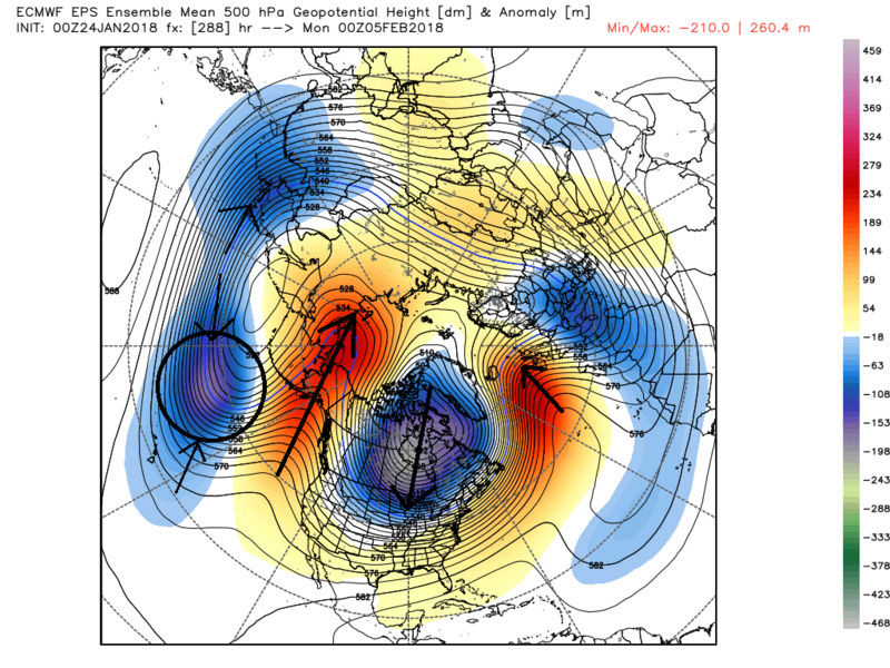
But again this is now looking more and more likely this change to the pattern is happening a tad earlier than prev anticipated. As you can see below that by the 3rd this big picture proverbial wheels appear to have been set in motion already. Below the two maps are both for the 00z on Feb 3rd. The first is from the 00z Jan 22nd run and the second is from last nights 00z. Again you can see the evolution in the means with more trough further east, because there is a stronger ridge complex up through and north of Alaska compared to prev runs.
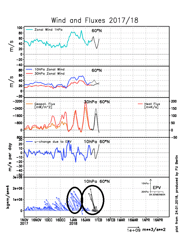
So whats driving all this? Answer: The changes to the strat. As you can see below the strat took a fairly decent wave 1 attack, left hook to the body, which has consequently weekend it and dropped its proverbial hands leaving it vulnerable to a follow up attack. The trigger to these attacks on the stratospheric polar vortex I believe is in part via the very strong MJO wave propagation(first wave 1 attack), the anomalously strong WPO ridging forcasted to go up at the end of this month(follow up wave 1 attack coming), combined with the fact that we have an easterly QBO this season(enhances the effects of the wave 1 or 2 attacks on the strat when compared to a strong westerly QBO).
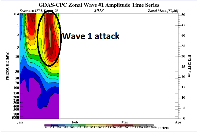
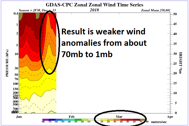
As you can see below the area circled with blue arrows is the first wave 1 attack, and the black arrows circled is a second wave 1 attack predicted to occur between now and the end of the month. So a nice left hook to the body has dropped the hands, but hopefully the follow up right hook to the head knocks it out. Even if it doesn't knock out the strat, a true sudden marked strat warming event) it will/should further disrupt it enough such that we should lock in a favorable pattern for the est of Feb and into arly March. There are also rumblings of a follow up wave 2 attack as we head towards the 10-15th of Feb which would likely occur if the MJO continues to propagate with its same robust amplitude into phase 8-1-2 as it is now through 4-5-6-7. Ifthis in fact happened, Wave 2 attack on an already vulnerable start PV, it would def finish the job and perhaps set us up for a truly memorable 6-8week finish to the winter season.
I am very confident in the time frame from Feb 5th through the end of Feb being loaded with opportunity. A side note I guess would be that if or when the MJO makes it into the cold phases, and all drivers, and pattern enhances align (favorable strat, MJO in favorable phases, SOI coming towards neutral or even go negative, -EPO/-AO/+PNA/-WPO temp departures from normal could rival if not surpass the prev run of anomalously low temps we had to end Dec and begin the month of Jan this season.
Last edited by sroc4 on Wed Jan 24, 2018 5:54 pm; edited 1 time in total
_________________
"In weather and in life, there's no winning and losing; there's only winning and learning."
WINTER 2012/2013 TOTALS 43.65"WINTER 2017/2018 TOTALS 62.85" WINTER 2022/2023 TOTALS 4.9"
WINTER 2013/2014 TOTALS 64.85"WINTER 2018/2019 TOTALS 14.25" WINTER 2023/2024 TOTALS 13.1"
WINTER 2014/2015 TOTALS 71.20"WINTER 2019/2020 TOTALS 6.35"
WINTER 2015/2016 TOTALS 35.00"WINTER 2020/2021 TOTALS 37.75"
WINTER 2016/2017 TOTALS 42.25"WINTER 2021/2022 TOTALS 31.65"
sroc4- Admin
- Posts : 8331
Reputation : 301
Join date : 2013-01-07
Location : Wading River, LI
Re: Long Range Thread 16.0
![]() by sroc4 Wed Jan 24, 2018 2:01 pm
by sroc4 Wed Jan 24, 2018 2:01 pm


_________________
"In weather and in life, there's no winning and losing; there's only winning and learning."
WINTER 2012/2013 TOTALS 43.65"WINTER 2017/2018 TOTALS 62.85" WINTER 2022/2023 TOTALS 4.9"
WINTER 2013/2014 TOTALS 64.85"WINTER 2018/2019 TOTALS 14.25" WINTER 2023/2024 TOTALS 13.1"
WINTER 2014/2015 TOTALS 71.20"WINTER 2019/2020 TOTALS 6.35"
WINTER 2015/2016 TOTALS 35.00"WINTER 2020/2021 TOTALS 37.75"
WINTER 2016/2017 TOTALS 42.25"WINTER 2021/2022 TOTALS 31.65"
sroc4- Admin
- Posts : 8331
Reputation : 301
Join date : 2013-01-07
Location : Wading River, LI
Re: Long Range Thread 16.0
![]() by amugs Wed Jan 24, 2018 2:54 pm
by amugs Wed Jan 24, 2018 2:54 pm

_________________
Mugs
AKA:King: Snow Weenie
Self Proclaimed
WINTER 2014-15 : 55.12" +.02 for 6 coatings (avg. 35")
WINTER 2015-16 Total - 29.8" (Avg 35")
WINTER 2016-17 : 39.5" so far
amugs- Advanced Forecaster - Mod
- Posts : 15091
Reputation : 213
Join date : 2013-01-07
Age : 54
Location : Hillsdale,NJ
Re: Long Range Thread 16.0
![]() by sroc4 Wed Jan 24, 2018 3:48 pm
by sroc4 Wed Jan 24, 2018 3:48 pm

_________________
"In weather and in life, there's no winning and losing; there's only winning and learning."
WINTER 2012/2013 TOTALS 43.65"WINTER 2017/2018 TOTALS 62.85" WINTER 2022/2023 TOTALS 4.9"
WINTER 2013/2014 TOTALS 64.85"WINTER 2018/2019 TOTALS 14.25" WINTER 2023/2024 TOTALS 13.1"
WINTER 2014/2015 TOTALS 71.20"WINTER 2019/2020 TOTALS 6.35"
WINTER 2015/2016 TOTALS 35.00"WINTER 2020/2021 TOTALS 37.75"
WINTER 2016/2017 TOTALS 42.25"WINTER 2021/2022 TOTALS 31.65"
sroc4- Admin
- Posts : 8331
Reputation : 301
Join date : 2013-01-07
Location : Wading River, LI
Re: Long Range Thread 16.0
![]() by sroc4 Wed Jan 24, 2018 3:49 pm
by sroc4 Wed Jan 24, 2018 3:49 pm
_________________
"In weather and in life, there's no winning and losing; there's only winning and learning."
WINTER 2012/2013 TOTALS 43.65"WINTER 2017/2018 TOTALS 62.85" WINTER 2022/2023 TOTALS 4.9"
WINTER 2013/2014 TOTALS 64.85"WINTER 2018/2019 TOTALS 14.25" WINTER 2023/2024 TOTALS 13.1"
WINTER 2014/2015 TOTALS 71.20"WINTER 2019/2020 TOTALS 6.35"
WINTER 2015/2016 TOTALS 35.00"WINTER 2020/2021 TOTALS 37.75"
WINTER 2016/2017 TOTALS 42.25"WINTER 2021/2022 TOTALS 31.65"
sroc4- Admin
- Posts : 8331
Reputation : 301
Join date : 2013-01-07
Location : Wading River, LI
Re: Long Range Thread 16.0
![]() by Guest Wed Jan 24, 2018 5:04 pm
by Guest Wed Jan 24, 2018 5:04 pm
Guest- Guest
Re: Long Range Thread 16.0
![]() by sroc4 Wed Jan 24, 2018 5:50 pm
by sroc4 Wed Jan 24, 2018 5:50 pm
syosnow94 wrote:Scott great write up. A question. You seem confident that we will flip back to winter around the 3rd with a storm threat or 2 between the 5th and 8th. But in the same post you said a system around the 8th will most likely cut. Which is it?
Here was my statement:
In my prev write up I used Feb 5th as my time line (see images above), but I really think its between the 3rd and the 5th that we see the true pattern change busting through, and am calling for 1-2 snow chances between the 5th and the 10th with the possibility of a close call between the 3rd-5th.
I couldn't find where I said anything specific would cut. Can you highlight it for me in a quote?
_________________
"In weather and in life, there's no winning and losing; there's only winning and learning."
WINTER 2012/2013 TOTALS 43.65"WINTER 2017/2018 TOTALS 62.85" WINTER 2022/2023 TOTALS 4.9"
WINTER 2013/2014 TOTALS 64.85"WINTER 2018/2019 TOTALS 14.25" WINTER 2023/2024 TOTALS 13.1"
WINTER 2014/2015 TOTALS 71.20"WINTER 2019/2020 TOTALS 6.35"
WINTER 2015/2016 TOTALS 35.00"WINTER 2020/2021 TOTALS 37.75"
WINTER 2016/2017 TOTALS 42.25"WINTER 2021/2022 TOTALS 31.65"
sroc4- Admin
- Posts : 8331
Reputation : 301
Join date : 2013-01-07
Location : Wading River, LI
Re: Long Range Thread 16.0
![]() by sroc4 Wed Jan 24, 2018 5:53 pm
by sroc4 Wed Jan 24, 2018 5:53 pm
sroc4 wrote:syosnow94 wrote:Scott great write up. A question. You seem confident that we will flip back to winter around the 3rd with a storm threat or 2 between the 5th and 8th. But in the same post you said a system around the 8th will most likely cut. Which is it?
Here was my statement:
In my prev write up I used Feb 5th as my time line (see images above), but I really think its between the 3rd and the 5th that we see the true pattern change busting through, and am calling for 1-2 snow chances between the 5th and the 10th with the possibility of a close call between the 3rd-5th.
I couldn't find where I said anything specific would cut. Can you highlight it for me in a quote?
I see the confusion...let me fix it. For some reason when I quoted myself from the other day it didnt quote normally. It looks like the entire thing was all written today. Hold on
_________________
"In weather and in life, there's no winning and losing; there's only winning and learning."
WINTER 2012/2013 TOTALS 43.65"WINTER 2017/2018 TOTALS 62.85" WINTER 2022/2023 TOTALS 4.9"
WINTER 2013/2014 TOTALS 64.85"WINTER 2018/2019 TOTALS 14.25" WINTER 2023/2024 TOTALS 13.1"
WINTER 2014/2015 TOTALS 71.20"WINTER 2019/2020 TOTALS 6.35"
WINTER 2015/2016 TOTALS 35.00"WINTER 2020/2021 TOTALS 37.75"
WINTER 2016/2017 TOTALS 42.25"WINTER 2021/2022 TOTALS 31.65"
sroc4- Admin
- Posts : 8331
Reputation : 301
Join date : 2013-01-07
Location : Wading River, LI
Re: Long Range Thread 16.0
![]() by sroc4 Wed Jan 24, 2018 5:58 pm
by sroc4 Wed Jan 24, 2018 5:58 pm
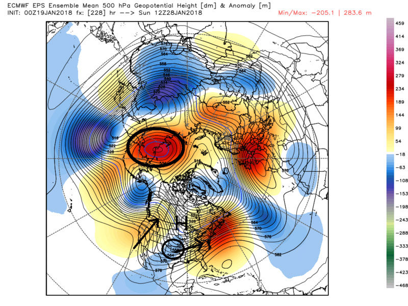
sroc4 wrote:by sroc4 on Sun Jan 21, 2018 12:46 pm
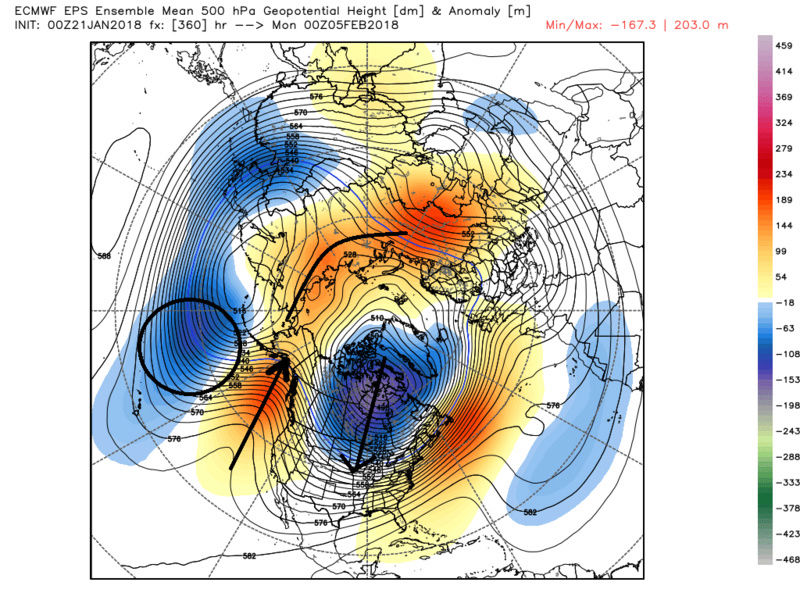
Lets get back to the weather. Here is the first sign of the pattern shifting back to more sustained cold. Its long range so grain of salt for now but fits very nicely with the anticipated start to the sustained cold and snow chances. You can see a trough showing up S of the Aleutian islands which lends itself to a ridge then a full lat trough over NA showing up in the means of the ens. If you look at the MSLP anomalies when you start to see the HP building in this configuration the cold is coming. Verbatim the ridge axis is likely too far west for a snow storm for the east coast, but if I had to guess there would be a decent system develop from this look around the 4th-8th time frame that would prob cut but be the key to unlock the cold shortly after this from the 8th-12th time frame. Images are saved so we can follow along with the evolution a we go along in time.
Update on the 27th-30th time frame coming early this week.
Second: Regarding the pattern flip in the first week of Feb. Recall the above discussion regarding our pattern shift back to a more favorable one for consistent cold and snow around the 5th. There is ZERO doubt in my mind that we are headed back to the promise land for most of the month of Feb. In my prev write up I used Feb 5th as my time line (see images above), but I really think its between the 3rd and the 5th that we see the true pattern change busting through, and am calling for 1-2 snow chances between the 5th and the 10th with the possibility of a close call between the 3rd-5th.
As you can see the evolution in the means has trended much stronger with the ridging in the PNA/EPO regions and more focused with the sub Aleutian trough.
Prev map above followed by most recent.
As more and more members cont to consolidate on a stronger sub Aleutian trough the result will be to cont to trend stronger in the west with the +PNA/-EPO ridge. This in turn will cont to reinforce the cold pool building over Canada compliments of displacing the Trop polar Vortex south off the pole due to the aforementioned blocking, and consequently this cold air floods the country. Now during this time frame, 3rd-10th or so +/-, thanks to the brilliant discussion by Ray the MJO, Trop Pac forcing(SOI), will still be propagating through phase 7 of the MJO which is a transitional phase. The result of this depending on where, and how robust it is during this phase seven could result in the SE ridge still ever so slightly being part of the equation. Now I say this actually in a good way. This would set up a very tight thermal gradient, aka baroclinic zone, for which rapid intensification or unexpected enhancement to even weak systems riding this area would take place due to this very sharp contrast between temps between air masses. During this period we no longer have modified Pacific air via the more zonal progressive flow we are in now, but rather this is polar and arctic origins compliments of the -EPO/+PNA/-WPO/-AO blocking forcing the jet stream in the Pac to make a turn north into the artcic regions before driving back south into NA, aka Pacific wave break, running up against a warm subtropical origin.
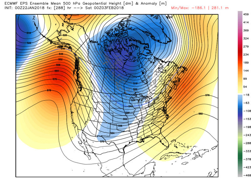
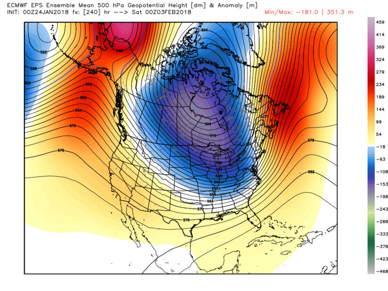
But again this is now looking more and more likely this change to the pattern is happening a tad earlier than prev anticipated. As you can see below that by the 3rd this big picture proverbial wheels appear to have been set in motion already. Below the two maps are both for the 00z on Feb 3rd. The first is from the 00z Jan 22nd run and the second is from last nights 00z. Again you can see the evolution in the means with more trough further east, because there is a stronger ridge complex up through and north of Alaska compared to prev runs.
So whats driving all this? Answer: The changes to the strat. As you can see below the strat took a fairly decent wave 1 attack, left hook to the body, which has consequently weekend it and dropped its proverbial hands leaving it vulnerable to a follow up attack. The trigger to these attacks on the stratospheric polar vortex I believe is in part via the very strong MJO wave propagation(first wave 1 attack), the anomalously strong WPO ridging forcasted to go up at the end of this month(follow up wave 1 attack coming), combined with the fact that we have an easterly QBO this season(enhances the effects of the wave 1 or 2 attacks on the strat when compared to a strong westerly QBO).
As you can see below the area circled with blue arrows is the first wave 1 attack, and the black arrows circled is a second wave 1 attack predicted to occur between now and the end of the month. So a nice left hook to the body has dropped the hands, but hopefully the follow up right hook to the head knocks it out. Even if it doesn't knock out the strat, a true sudden marked strat warming event) it will/should further disrupt it enough such that we should lock in a favorable pattern for the est of Feb and into arly March. There are also rumblings of a follow up wave 2 attack as we head towards the 10-15th of Feb which would likely occur if the MJO continues to propagate with its same robust amplitude into phase 8-1-2 as it is now through 4-5-6-7. Ifthis in fact happened, Wave 2 attack on an already vulnerable start PV, it would def finish the job and perhaps set us up for a truly memorable 6-8week finish to the winter season.
I am very confident in the time frame from Feb 5th through the end of Feb being loaded with opportunity. A side note I guess would be that if or when the MJO makes it into the cold phases, and all drivers, and pattern enhances align (favorable strat, MJO in favorable phases, SOI coming towards neutral or even go negative, -EPO/-AO/+PNA/-WPO temp departures from normal could rival if not surpass the prev run of anomalously low temps we had to end Dec and begin the month of Jan this season.
Last edited by sroc4 on Wed Jan 24, 2018 6:01 pm; edited 1 time in total
_________________
"In weather and in life, there's no winning and losing; there's only winning and learning."
WINTER 2012/2013 TOTALS 43.65"WINTER 2017/2018 TOTALS 62.85" WINTER 2022/2023 TOTALS 4.9"
WINTER 2013/2014 TOTALS 64.85"WINTER 2018/2019 TOTALS 14.25" WINTER 2023/2024 TOTALS 13.1"
WINTER 2014/2015 TOTALS 71.20"WINTER 2019/2020 TOTALS 6.35"
WINTER 2015/2016 TOTALS 35.00"WINTER 2020/2021 TOTALS 37.75"
WINTER 2016/2017 TOTALS 42.25"WINTER 2021/2022 TOTALS 31.65"
sroc4- Admin
- Posts : 8331
Reputation : 301
Join date : 2013-01-07
Location : Wading River, LI
Re: Long Range Thread 16.0
![]() by sroc4 Wed Jan 24, 2018 6:01 pm
by sroc4 Wed Jan 24, 2018 6:01 pm
sroc4 wrote:sroc4 wrote:syosnow94 wrote:Scott great write up. A question. You seem confident that we will flip back to winter around the 3rd with a storm threat or 2 between the 5th and 8th. But in the same post you said a system around the 8th will most likely cut. Which is it?
Here was my statement:
In my prev write up I used Feb 5th as my time line (see images above), but I really think its between the 3rd and the 5th that we see the true pattern change busting through, and am calling for 1-2 snow chances between the 5th and the 10th with the possibility of a close call between the 3rd-5th.
I couldn't find where I said anything specific would cut. Can you highlight it for me in a quote?
I see the confusion...let me fix it. For some reason when I quoted myself from the other day it didnt quote normally. It looks like the entire thing was all written today. Hold on
Where I said it would cut between the 4th-8th was when I was evaluating modeling from back on the 21st which is when the original write up was. As of today the ideas have evolved a little. Hope this clears it up
_________________
"In weather and in life, there's no winning and losing; there's only winning and learning."
WINTER 2012/2013 TOTALS 43.65"WINTER 2017/2018 TOTALS 62.85" WINTER 2022/2023 TOTALS 4.9"
WINTER 2013/2014 TOTALS 64.85"WINTER 2018/2019 TOTALS 14.25" WINTER 2023/2024 TOTALS 13.1"
WINTER 2014/2015 TOTALS 71.20"WINTER 2019/2020 TOTALS 6.35"
WINTER 2015/2016 TOTALS 35.00"WINTER 2020/2021 TOTALS 37.75"
WINTER 2016/2017 TOTALS 42.25"WINTER 2021/2022 TOTALS 31.65"
sroc4- Admin
- Posts : 8331
Reputation : 301
Join date : 2013-01-07
Location : Wading River, LI
Re: Long Range Thread 16.0
![]() by amugs Wed Jan 24, 2018 7:51 pm
by amugs Wed Jan 24, 2018 7:51 pm
It will be an ealien intrusion of cold due to the fact we have a N EPO and WPO couplet at large that are keeping Canada frigid wPO bit when we get the AL vortex in the Gulf of Alaska pumping it will send the cross polar flow through the UMW into the NE. Look at this potent bad boy sitting in a great spot for us on the west shores of Hudson bay. Map from Ventrice on WSI. Feb 3rd peeps Super Bowl weekend.

_________________
Mugs
AKA:King: Snow Weenie
Self Proclaimed
WINTER 2014-15 : 55.12" +.02 for 6 coatings (avg. 35")
WINTER 2015-16 Total - 29.8" (Avg 35")
WINTER 2016-17 : 39.5" so far
amugs- Advanced Forecaster - Mod
- Posts : 15091
Reputation : 213
Join date : 2013-01-07
Age : 54
Location : Hillsdale,NJ
Re: Long Range Thread 16.0
![]() by Frank_Wx Fri Jan 26, 2018 9:46 am
by Frank_Wx Fri Jan 26, 2018 9:46 am
In my opinion I do not think the pattern is 'ready' by February 2nd to bring us a substantial snow event. I think it needs to settle in a bit. I do think we'll see a fairly significant snowfall event occur between February 5th and 15th.
_________________
_______________________________________________________________________________________________________
CLICK HERE to view NJ Strong Snowstorm Classifications

Frank_Wx- Godzilla Seeker
- Posts : 21305
Reputation : 328
Join date : 2013-01-05
Age : 31
Location : Jersey City, NJ -

Re: Long Range Thread 16.0
![]() by skinsfan1177 Fri Jan 26, 2018 1:29 pm
by skinsfan1177 Fri Jan 26, 2018 1:29 pm

skinsfan1177- Senior Enthusiast
- Posts : 4485
Reputation : 35
Join date : 2013-01-07
Age : 46
Location : Point Pleasant Boro
Re: Long Range Thread 16.0
![]() by sroc4 Fri Jan 26, 2018 1:49 pm
by sroc4 Fri Jan 26, 2018 1:49 pm
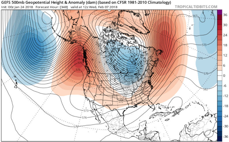
Math23x7 wrote:.....in the meantime, hr 240 of the 12Z EURO has 500 mb heights exceeding 576 dm across the tri-state area and exceeding 582 dm in the Hampton, such heights being more typical of a summertime airmass:
https://www.tropicaltidbits.com/analysis/models/?model=ecmwf®ion=eus&pkg=z500_mslp&runtime=2018012212&fh=240
Another example of why you simply cant hug an operational model in the LR. Recall this post. Here was the anomalies from that time frame compared to the current euro op forcast for 500mb height anomalies, and 850mb temp anomalies. Evolution and pattern recognition


_________________
"In weather and in life, there's no winning and losing; there's only winning and learning."
WINTER 2012/2013 TOTALS 43.65"WINTER 2017/2018 TOTALS 62.85" WINTER 2022/2023 TOTALS 4.9"
WINTER 2013/2014 TOTALS 64.85"WINTER 2018/2019 TOTALS 14.25" WINTER 2023/2024 TOTALS 13.1"
WINTER 2014/2015 TOTALS 71.20"WINTER 2019/2020 TOTALS 6.35"
WINTER 2015/2016 TOTALS 35.00"WINTER 2020/2021 TOTALS 37.75"
WINTER 2016/2017 TOTALS 42.25"WINTER 2021/2022 TOTALS 31.65"
sroc4- Admin
- Posts : 8331
Reputation : 301
Join date : 2013-01-07
Location : Wading River, LI
Re: Long Range Thread 16.0
![]() by jmanley32 Fri Jan 26, 2018 7:07 pm
by jmanley32 Fri Jan 26, 2018 7:07 pm

jmanley32- Senior Enthusiast
- Posts : 20512
Reputation : 108
Join date : 2013-12-12
Age : 42
Location : Yonkers, NY
Re: Long Range Thread 16.0
![]() by jmanley32 Fri Jan 26, 2018 11:50 pm
by jmanley32 Fri Jan 26, 2018 11:50 pm
jmanley32- Senior Enthusiast
- Posts : 20512
Reputation : 108
Join date : 2013-12-12
Age : 42
Location : Yonkers, NY
Re: Long Range Thread 16.0
![]() by Math23x7 Sat Jan 27, 2018 1:53 am
by Math23x7 Sat Jan 27, 2018 1:53 am
Math23x7- Wx Statistician Guru
- Posts : 2379
Reputation : 68
Join date : 2013-01-08
Re: Long Range Thread 16.0
![]() by sroc4 Sat Jan 27, 2018 7:32 am
by sroc4 Sat Jan 27, 2018 7:32 am
_________________
"In weather and in life, there's no winning and losing; there's only winning and learning."
WINTER 2012/2013 TOTALS 43.65"WINTER 2017/2018 TOTALS 62.85" WINTER 2022/2023 TOTALS 4.9"
WINTER 2013/2014 TOTALS 64.85"WINTER 2018/2019 TOTALS 14.25" WINTER 2023/2024 TOTALS 13.1"
WINTER 2014/2015 TOTALS 71.20"WINTER 2019/2020 TOTALS 6.35"
WINTER 2015/2016 TOTALS 35.00"WINTER 2020/2021 TOTALS 37.75"
WINTER 2016/2017 TOTALS 42.25"WINTER 2021/2022 TOTALS 31.65"
sroc4- Admin
- Posts : 8331
Reputation : 301
Join date : 2013-01-07
Location : Wading River, LI
Page 32 of 40 • 1 ... 17 ... 31, 32, 33 ... 36 ... 40 ![]()
|
|
|