
 Search
March Madness! Spring Snowstorm Observations Part II
Page 9 of 28 •  1 ... 6 ... 8, 9, 10 ... 18 ... 28
 ![]()
Re: March Madness! Spring Snowstorm Observations Part II
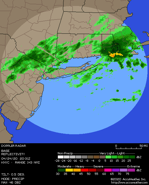
![]() by aiannone Wed Mar 21, 2018 4:41 pm
by aiannone Wed Mar 21, 2018 4:41 pm
aiannone- Senior Enthusiast - Mod

- Posts : 4813
Join date : 2013-01-07
Re: March Madness! Spring Snowstorm Observations Part II
![]() by jmanley32 Wed Mar 21, 2018 4:42 pm
by jmanley32 Wed Mar 21, 2018 4:42 pm
jmanley32- Senior Enthusiast

- Posts : 20512
Join date : 2013-12-12
Re: March Madness! Spring Snowstorm Observations Part II
![]() by pdubz Wed Mar 21, 2018 4:45 pm
by pdubz Wed Mar 21, 2018 4:45 pm

pdubz- Pro Enthusiast

- Posts : 539
Reputation : 0
Join date : 2013-09-24
Age : 32
Location : Port Washington,NY (L.I)
Re: March Madness! Spring Snowstorm Observations Part II
![]() by CPcantmeasuresnow Wed Mar 21, 2018 4:47 pm
by CPcantmeasuresnow Wed Mar 21, 2018 4:47 pm
This now puts them at 32 inches for the season which makes the fifth year in a row they've gone over 30 inches. That's the first time they've had five years in succession over 30 inches since the 1880s.
That was done with two of those five meteorological winters being among the six warmest in history. That's what makes it impressive to me more than anything.
At least I have that today.

CPcantmeasuresnow- Wx Statistician Guru

- Posts : 7274
Reputation : 230
Join date : 2013-01-07
Age : 103
Location : Eastern Orange County, NY
Re: March Madness! Spring Snowstorm Observations Part II
![]() by billg315 Wed Mar 21, 2018 4:48 pm
by billg315 Wed Mar 21, 2018 4:48 pm

billg315- Advanced Forecaster - Mod
- Posts : 4461
Reputation : 185
Join date : 2015-01-24
Age : 50
Location : Flemington, NJ
Re: March Madness! Spring Snowstorm Observations Part II
![]() by jmanley32 Wed Mar 21, 2018 4:49 pm
by jmanley32 Wed Mar 21, 2018 4:49 pm

jmanley32- Senior Enthusiast
- Posts : 20512
Reputation : 108
Join date : 2013-12-12
Age : 42
Location : Yonkers, NY
Re: March Madness! Spring Snowstorm Observations Part II
![]() by WeatherBob Wed Mar 21, 2018 4:51 pm
by WeatherBob Wed Mar 21, 2018 4:51 pm

WeatherBob- Meteorologist

- Posts : 683
Reputation : 83
Join date : 2013-12-13
Location : Caldwell, NJ - NW Essex County - Altitude 500 FT
Re: March Madness! Spring Snowstorm Observations Part II
![]() by weatherwatchermom Wed Mar 21, 2018 4:52 pm
by weatherwatchermom Wed Mar 21, 2018 4:52 pm

weatherwatchermom- Senior Enthusiast
- Posts : 3730
Reputation : 77
Join date : 2014-11-25
Age : 60
Location : Hazlet Township, NJ
Re: March Madness! Spring Snowstorm Observations Part II
![]() by aiannone Wed Mar 21, 2018 4:54 pm
by aiannone Wed Mar 21, 2018 4:54 pm
Winter Storm Still Expected to Impact the region, especially
for New York City and Long Island, with more snow on the way
tonight. Total storm total snow still ranges from 8 to 14
inches by Thursday morning. The snow could linger into early
Thursday for Long Island and Southeast Connecticut.
Upper level low swings southeast of Long Island, taking a
position well SE of Nantucket and Martha`s Vineyard by early
Thursday. A surface low will deepen 3-5 mb this evening as it
passes southeast of the 40N/70W benchmark. Before 06Z, the
models show a consolidation of moisture and this would be
manifested as banding.
With the occurrence of this being at night, temperatures are
expected to more easily drop with the snowfall, allowing more
accumulations tonight for quite a few places than what was seen
earlier today. A deep vertical layer of lift and moisture is
shown by BUFKIT soundings across mainly the coastal areas
through this evening. With less depth to the moisture and lift
farther north. There are increases in the 850-700mb
frontogenesis mainly this evening. Still have gusty winds in the
forecast as well with the deepening of the low and the increase
of the pressure gradient.
Hence, some small changes were made to snowfall; more to the NW
across Orange, Putnam, Northern Fairfield, Northern New Haven, snow
was lowered a few inches. It was kept pretty much the same
elsewhere as due to the aforementioned increase in dynamic lift
this evening, thinking there is quite a potential for an
additional 6-9 inches of snow for all of tonight. Another
notable change was the extension of SE Connecticut and Eastern
Suffolk to 8am for the winter storm warning, where snow will not
taper off until near daybreak Thursday.
Lows were taken from NAM 2 meter temperatures and slightly
adjusted down, upper 20s to lower 30s.
_________________
-Alex Iannone-

aiannone- Senior Enthusiast - Mod
- Posts : 4813
Reputation : 92
Join date : 2013-01-07
Location : Saint James, LI (Northwest Suffolk Co.)
Re: March Madness! Spring Snowstorm Observations Part II
![]() by frank 638 Wed Mar 21, 2018 4:56 pm
by frank 638 Wed Mar 21, 2018 4:56 pm
by me it has started snowing and its coming down pretty good nice big fat flakes hang in there it will start soon
frank 638- Senior Enthusiast
- Posts : 2823
Reputation : 37
Join date : 2016-01-01
Age : 40
Location : bronx ny
Re: March Madness! Spring Snowstorm Observations Part II
![]() by Joe Snow Wed Mar 21, 2018 4:58 pm
by Joe Snow Wed Mar 21, 2018 4:58 pm
https://mobile.twitter.com/StuOstro/status/976553256041304066/photo/1

Joe Snow- Pro Enthusiast
- Posts : 924
Reputation : 7
Join date : 2014-02-12
Age : 62
Location : Sanford Florida, Fmrly Kings Park, NY
Re: March Madness! Spring Snowstorm Observations Part II
![]() by jmanley32 Wed Mar 21, 2018 4:58 pm
by jmanley32 Wed Mar 21, 2018 4:58 pm
Thats encouragiung, hopefully it overperforms right over me and soul ; )aiannone wrote:.NEAR TERM /UNTIL 6 AM THURSDAY MORNING/...
Winter Storm Still Expected to Impact the region, especially
for New York City and Long Island, with more snow on the way
tonight. Total storm total snow still ranges from 8 to 14
inches by Thursday morning. The snow could linger into early
Thursday for Long Island and Southeast Connecticut.
Upper level low swings southeast of Long Island, taking a
position well SE of Nantucket and Martha`s Vineyard by early
Thursday. A surface low will deepen 3-5 mb this evening as it
passes southeast of the 40N/70W benchmark. Before 06Z, the
models show a consolidation of moisture and this would be
manifested as banding.
With the occurrence of this being at night, temperatures are
expected to more easily drop with the snowfall, allowing more
accumulations tonight for quite a few places than what was seen
earlier today. A deep vertical layer of lift and moisture is
shown by BUFKIT soundings across mainly the coastal areas
through this evening. With less depth to the moisture and lift
farther north. There are increases in the 850-700mb
frontogenesis mainly this evening. Still have gusty winds in the
forecast as well with the deepening of the low and the increase
of the pressure gradient.
Hence, some small changes were made to snowfall; more to the NW
across Orange, Putnam, Northern Fairfield, Northern New Haven, snow
was lowered a few inches. It was kept pretty much the same
elsewhere as due to the aforementioned increase in dynamic lift
this evening, thinking there is quite a potential for an
additional 6-9 inches of snow for all of tonight. Another
notable change was the extension of SE Connecticut and Eastern
Suffolk to 8am for the winter storm warning, where snow will not
taper off until near daybreak Thursday.
Lows were taken from NAM 2 meter temperatures and slightly
adjusted down, upper 20s to lower 30s.
jmanley32- Senior Enthusiast
- Posts : 20512
Reputation : 108
Join date : 2013-12-12
Age : 42
Location : Yonkers, NY
Re: March Madness! Spring Snowstorm Observations Part II
![]() by Vinnydula Wed Mar 21, 2018 4:59 pm
by Vinnydula Wed Mar 21, 2018 4:59 pm

Vinnydula- Pro Enthusiast
- Posts : 778
Reputation : 8
Join date : 2013-12-12
Location : Dobbs ferry
Re: March Madness! Spring Snowstorm Observations Part II
![]() by jmanley32 Wed Mar 21, 2018 5:00 pm
by jmanley32 Wed Mar 21, 2018 5:00 pm
I see it, there was a break in the banding its just south of me in the BX.frank 638 wrote:jmanley32 wrote:Oh no its stopped snowing completely, radar shows me in snow though, hope its not that dreaded word.[/quote
by me it has started snowing and its coming down pretty good nice big fat flakes hang in there it will start soon
jmanley32- Senior Enthusiast
- Posts : 20512
Reputation : 108
Join date : 2013-12-12
Age : 42
Location : Yonkers, NY
Re: March Madness! Spring Snowstorm Observations Part II
![]() by SoulSingMG Wed Mar 21, 2018 5:02 pm
by SoulSingMG Wed Mar 21, 2018 5:02 pm


SoulSingMG- Senior Enthusiast
- Posts : 2853
Reputation : 74
Join date : 2013-12-11
Location : Long Island City, NY
Re: March Madness! Spring Snowstorm Observations Part II
![]() by Dtone Wed Mar 21, 2018 5:03 pm
by Dtone Wed Mar 21, 2018 5:03 pm
Dtone- Wx Statistician Guru
- Posts : 1738
Reputation : 9
Join date : 2013-08-26
Location : Bronx, NY
Re: March Madness! Spring Snowstorm Observations Part II
![]() by Taffy Wed Mar 21, 2018 5:04 pm
by Taffy Wed Mar 21, 2018 5:04 pm
Last edited by Taffy on Wed Mar 21, 2018 5:07 pm; edited 1 time in total

Taffy- Pro Enthusiast
- Posts : 530
Reputation : 19
Join date : 2013-10-06
Location : Hopkinton, MA
Re: March Madness! Spring Snowstorm Observations Part II
![]() by lglickman Wed Mar 21, 2018 5:05 pm
by lglickman Wed Mar 21, 2018 5:05 pm
lglickman- Posts : 8
Reputation : 0
Join date : 2013-02-11
Re: March Madness! Spring Snowstorm Observations Part II
![]() by amugs Wed Mar 21, 2018 5:05 pm
by amugs Wed Mar 21, 2018 5:05 pm
_________________
Mugs
AKA:King: Snow Weenie
Self Proclaimed
WINTER 2014-15 : 55.12" +.02 for 6 coatings (avg. 35")
WINTER 2015-16 Total - 29.8" (Avg 35")
WINTER 2016-17 : 39.5" so far

amugs- Advanced Forecaster - Mod
- Posts : 15091
Reputation : 213
Join date : 2013-01-07
Age : 54
Location : Hillsdale,NJ
Re: March Madness! Spring Snowstorm Observations Part II
![]() by Dtone Wed Mar 21, 2018 5:05 pm
by Dtone Wed Mar 21, 2018 5:05 pm
SoulSingMG wrote:Ouch. That subsidence over me is REAL.
damn, I'm in that band, I dont think its moved much at all. Wind picking up too
Dtone- Wx Statistician Guru
- Posts : 1738
Reputation : 9
Join date : 2013-08-26
Location : Bronx, NY
Re: March Madness! Spring Snowstorm Observations Part II
![]() by Guest Wed Mar 21, 2018 5:08 pm
by Guest Wed Mar 21, 2018 5:08 pm
Guest- Guest
Re: March Madness! Spring Snowstorm Observations Part II
![]() by crippo84 Wed Mar 21, 2018 5:09 pm
by crippo84 Wed Mar 21, 2018 5:09 pm

crippo84- Posts : 383
Reputation : 20
Join date : 2013-11-07
Age : 40
Location : East Village, NYC
Re: March Madness! Spring Snowstorm Observations Part II
![]() by jmanley32 Wed Mar 21, 2018 5:11 pm
by jmanley32 Wed Mar 21, 2018 5:11 pm
ur not kidding soul, its dead here too, yet dtone a few miles south of here is getting blitzed, can that band move in?SoulSingMG wrote:Ouch. That subsidence over me is REAL.
jmanley32- Senior Enthusiast
- Posts : 20512
Reputation : 108
Join date : 2013-12-12
Age : 42
Location : Yonkers, NY
Re: March Madness! Spring Snowstorm Observations Part II
![]() by Guest Wed Mar 21, 2018 5:12 pm
by Guest Wed Mar 21, 2018 5:12 pm
Guest- Guest
Re: March Madness! Spring Snowstorm Observations Part II
![]() by nujerzeedevil Wed Mar 21, 2018 5:12 pm
by nujerzeedevil Wed Mar 21, 2018 5:12 pm

nujerzeedevil- Posts : 121
Reputation : 14
Join date : 2013-12-30
Location : Bayville, NJ
Re: March Madness! Spring Snowstorm Observations Part II
![]() by dkodgis Wed Mar 21, 2018 5:13 pm
by dkodgis Wed Mar 21, 2018 5:13 pm

dkodgis- Senior Enthusiast
- Posts : 2492
Reputation : 98
Join date : 2013-12-29
Re: March Madness! Spring Snowstorm Observations Part II
![]() by jmanley32 Wed Mar 21, 2018 5:13 pm
by jmanley32 Wed Mar 21, 2018 5:13 pm
jmanley32- Senior Enthusiast
- Posts : 20512
Reputation : 108
Join date : 2013-12-12
Age : 42
Location : Yonkers, NY
Page 9 of 28 • 1 ... 6 ... 8, 9, 10 ... 18 ... 28 ![]()
|
|
|