
 Search
Long Range Thread 18.0
Page 17 of 36 •  1 ... 10 ... 16, 17, 18 ... 26 ... 36
 ![]()
Re: Long Range Thread 18.0
![]() by amugs Tue Jan 22, 2019 2:09 pm
by amugs Tue Jan 22, 2019 2:09 pm
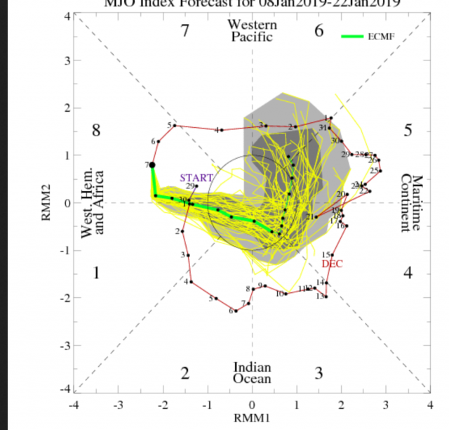
This pattern has been the same since early Dec and you know that nature loves to lock in patterns. We need NAO help or the WC ridge to slide further east east .
From JB and Scot brought this up about the MJO and where teh convection is - and it isnt suppose to dry out over the warm phases until.............next week now - for the love of god it was to be a slingshot run through these phases for 3-5 days now were are up to 10 days
.gif)
.png)
This though this jet streak looks good to me for Sunday into Monday on the GEFS overall - needs some work though


Need about 100 miles more south for my liking at this stage for everyone here to see snow

The Best storms pop up within the 5 day range so holding out over the next two days for this Sunday into Monday event.
As one met said we keep saying 7 days it will change adn the other factors come into play and squash us - ala the dismal winter 11-12 winter
amugs- Advanced Forecaster - Mod

- Posts : 15091
Join date : 2013-01-07
Re: Long Range Thread 18.0
![]() by dkodgis Tue Jan 22, 2019 3:12 pm
by dkodgis Tue Jan 22, 2019 3:12 pm
n-o-r-m-a-l
I don't wanna believe it
dkodgis- Senior Enthusiast

- Posts : 2492
Join date : 2013-12-29
Re: Long Range Thread 18.0
![]() by amugs Tue Jan 22, 2019 5:06 pm
by amugs Tue Jan 22, 2019 5:06 pm
dkodgis wrote:Short long range: I notice lots of rain Wed and Thurs (am). I also notice that Thursday could be what...50 degrees? I guess this all is the new normal.
n-o-r-m-a-l
I don't wanna believe it
For this winter so far yes, not the overall.
_________________
Mugs
AKA:King: Snow Weenie
Self Proclaimed
WINTER 2014-15 : 55.12" +.02 for 6 coatings (avg. 35")
WINTER 2015-16 Total - 29.8" (Avg 35")
WINTER 2016-17 : 39.5" so far

amugs- Advanced Forecaster - Mod
- Posts : 15091
Reputation : 213
Join date : 2013-01-07
Age : 54
Location : Hillsdale,NJ
Re: Long Range Thread 18.0
![]() by sroc4 Tue Jan 22, 2019 6:35 pm
by sroc4 Tue Jan 22, 2019 6:35 pm
CPcantmeasuresnow wrote:amugs wrote:EPS the cold is here
No offense to you or any of the experts, but these maps a week or more out have become meaningless this winter.

No offense taken. There has been a lot of “the boy who cried wolf this winter”. But make no mistake the wolf is out there. Maybe he shows up maybe he won’t. But the pattern is fundamentally different from the December pattern even if the results haven’t been. If timing is right good things can happen. Even though there are fundamental changes that are favorable there are still residual unfavorable drivers, the MJO, that have an influence. I’d be willing to bet that if the pattern we have was set up in late December most of everyone would be very excited at the prospects despite not being perfect. Unfort it’s the end of Jan and we’ve been burned several times so far so the hesitance is real. Myself included. We wait. I’m ready to accept what ever fate MN has for me. I’ve had 6 consecutive seasons of AN snowfall. Something has to give. If people want to turn it in and give up I get it. But I’m not turning my back just yet
Last edited by sroc4 on Wed Jan 23, 2019 6:27 am; edited 1 time in total
_________________
"In weather and in life, there's no winning and losing; there's only winning and learning."
WINTER 2012/2013 TOTALS 43.65"WINTER 2017/2018 TOTALS 62.85" WINTER 2022/2023 TOTALS 4.9"
WINTER 2013/2014 TOTALS 64.85"WINTER 2018/2019 TOTALS 14.25" WINTER 2023/2024 TOTALS 13.1"
WINTER 2014/2015 TOTALS 71.20"WINTER 2019/2020 TOTALS 6.35"
WINTER 2015/2016 TOTALS 35.00"WINTER 2020/2021 TOTALS 37.75"
WINTER 2016/2017 TOTALS 42.25"WINTER 2021/2022 TOTALS 31.65"

sroc4- Admin

- Posts : 8331
Reputation : 301
Join date : 2013-01-07
Location : Wading River, LI
Re: Long Range Thread 18.0
![]() by Irish Tue Jan 22, 2019 9:13 pm
by Irish Tue Jan 22, 2019 9:13 pm

Irish- Pro Enthusiast

- Posts : 788
Reputation : 19
Join date : 2019-01-16
Age : 45
Location : Old Bridge, NJ
Re: Long Range Thread 18.0
![]() by sroc4 Wed Jan 23, 2019 6:44 am
by sroc4 Wed Jan 23, 2019 6:44 am
Irish wrote:Possible storms for January 29th and February 1-3?
The upper levels have the ingredients. They just need to come together. Unfort the MJO will be in phase 5-6 which is going to put up resistance. Meaning...the set up needs to be perfect. It’s a “don’t hold your breath” type of winter.
_________________
"In weather and in life, there's no winning and losing; there's only winning and learning."
WINTER 2012/2013 TOTALS 43.65"WINTER 2017/2018 TOTALS 62.85" WINTER 2022/2023 TOTALS 4.9"
WINTER 2013/2014 TOTALS 64.85"WINTER 2018/2019 TOTALS 14.25" WINTER 2023/2024 TOTALS 13.1"
WINTER 2014/2015 TOTALS 71.20"WINTER 2019/2020 TOTALS 6.35"
WINTER 2015/2016 TOTALS 35.00"WINTER 2020/2021 TOTALS 37.75"
WINTER 2016/2017 TOTALS 42.25"WINTER 2021/2022 TOTALS 31.65"
sroc4- Admin
- Posts : 8331
Reputation : 301
Join date : 2013-01-07
Location : Wading River, LI
Re: Long Range Thread 18.0
![]() by nutleyblizzard Wed Jan 23, 2019 6:49 am
by nutleyblizzard Wed Jan 23, 2019 6:49 am
The MJO is killing us. If I have to see Amy Freeze dressed up like a supermodel forecast another flood watch, I'm gonna lose it.sroc4 wrote:Irish wrote:Possible storms for January 29th and February 1-3?
The upper levels have the ingredients. They just need to come together. Unfort the MJO will be in phase 5-6 which is going to put up resistance. Meaning...the set up needs to be perfect. It’s a “don’t hold your breath” type of winter.

nutleyblizzard- Senior Enthusiast
- Posts : 1952
Reputation : 41
Join date : 2014-01-30
Age : 57
Location : Nutley, new jersey
Re: Long Range Thread 18.0
![]() by weatherwatchermom Wed Jan 23, 2019 6:58 am
by weatherwatchermom Wed Jan 23, 2019 6:58 am
COME ON!!! I WILL FINISH IN PLAY PENsroc4 wrote:Irish wrote:Possible storms for January 29th and February 1-3?
The upper levels have the ingredients. They just need to come together. Unfort the MJO will be in phase 5-6 which is going to put up resistance. Meaning...the set up needs to be perfect. It’s a “don’t hold your breath” type of winter.

weatherwatchermom- Senior Enthusiast
- Posts : 3730
Reputation : 77
Join date : 2014-11-25
Age : 60
Location : Hazlet Township, NJ
Re: Long Range Thread 18.0
![]() by Radz Wed Jan 23, 2019 7:11 am
by Radz Wed Jan 23, 2019 7:11 am
Long range threats are way too volatile - seems like (as has been said), until we are in the 5 day or closer range, its not even worth looking at. We need one to deliver soon...sroc4 wrote:Irish wrote:Possible storms for January 29th and February 1-3?
The upper levels have the ingredients. They just need to come together. Unfort the MJO will be in phase 5-6 which is going to put up resistance. Meaning...the set up needs to be perfect. It’s a “don’t hold your breath” type of winter.
Last edited by Radz on Wed Jan 23, 2019 7:46 am; edited 1 time in total

Radz- Pro Enthusiast
- Posts : 1028
Reputation : 17
Join date : 2013-01-12
Location : Cortlandt Manor NY
Re: Long Range Thread 18.0
![]() by Frank_Wx Wed Jan 23, 2019 7:44 am
by Frank_Wx Wed Jan 23, 2019 7:44 am
nutleyblizzard wrote:The MJO is killing us. If I have to see Amy Freeze dressed up like a supermodel forecast another flood watch, I'm gonna lose it.sroc4 wrote:Irish wrote:Possible storms for January 29th and February 1-3?
The upper levels have the ingredients. They just need to come together. Unfort the MJO will be in phase 5-6 which is going to put up resistance. Meaning...the set up needs to be perfect. It’s a “don’t hold your breath” type of winter.
weatherwatchermom wrote:COME ON!!! I WILL FINISH IN PLAY PENsroc4 wrote:Irish wrote:Possible storms for January 29th and February 1-3?
The upper levels have the ingredients. They just need to come together. Unfort the MJO will be in phase 5-6 which is going to put up resistance. Meaning...the set up needs to be perfect. It’s a “don’t hold your breath” type of winter.
Crack me up

_________________
_______________________________________________________________________________________________________
CLICK HERE to view NJ Strong Snowstorm Classifications

Frank_Wx- Godzilla Seeker
- Posts : 21305
Reputation : 328
Join date : 2013-01-05
Age : 31
Location : Jersey City, NJ -

Re: Long Range Thread 18.0
![]() by Frank_Wx Wed Jan 23, 2019 7:56 am
by Frank_Wx Wed Jan 23, 2019 7:56 am
The PAC jet retraction is a positive first step. But it's coming at a time when the MJO is also propagating through phases 4-5-6. Our timing this winter has been impeccably bad.
_________________
_______________________________________________________________________________________________________
CLICK HERE to view NJ Strong Snowstorm Classifications
Frank_Wx- Godzilla Seeker
- Posts : 21305
Reputation : 328
Join date : 2013-01-05
Age : 31
Location : Jersey City, NJ -
Re: Long Range Thread 18.0
![]() by SENJsnowman Wed Jan 23, 2019 8:35 am
by SENJsnowman Wed Jan 23, 2019 8:35 am
sroc4 wrote:
No offense taken. There has been a lot of “the boy who cried wolf this winter”. But make no mistake the wolf is out there. Maybe he shows up maybe he won’t. But the pattern is fundamentally different from the December pattern even if the results haven’t been. If timing is right good things can happen. Even though there are fundamental changes that are favorable there are still residual unfavorable drivers, the MJO, that have an influence. I’d be willing to bet that if the pattern we have was set up in late December most of everyone would be very excited at the prospects despite not being perfect. Unfort it’s the end of Jan and we’ve been burned several times so far so the hesitance is real. Myself included. We wait. I’m ready to accept what ever fate MN has for me. I’ve had 6 consecutive seasons of AN snowfall. Something has to give. If people want to turn it in and give up I get it. But I’m not turning my back just yet
I'm right here with you Scott (I'm a low value add, but I can help lift heavy things and I'm good with a broom, etc...).
Of course, December-January will have a huuuuuuuuuuuuuge negative impact on my winter grade...don't see it getting past a regular B in the best case, and even a B at this point would take like 2-3' of snow the rest of the way.
But, at the end of the day, I'd rather have a winter with one or two nice storms in it than zero. I'm kind of in sleep mode right now...but it won't take much till the snow dork in me awakes!
SENJsnowman- Senior Enthusiast
- Posts : 1186
Reputation : 61
Join date : 2017-01-06
Age : 51
Location : Bayville, NJ
Re: Long Range Thread 18.0
![]() by heehaw453 Wed Jan 23, 2019 1:46 pm
by heehaw453 Wed Jan 23, 2019 1:46 pm
I commend all those that still have belief in AN snowfall this year.
heehaw453- Advanced Forecaster

- Posts : 3906
Reputation : 86
Join date : 2014-01-20
Location : Bedminster Township, PA Elevation 600' ASL
Re: Long Range Thread 18.0
![]() by sroc4 Wed Jan 23, 2019 2:41 pm
by sroc4 Wed Jan 23, 2019 2:41 pm
heehaw453 wrote:Euro guidance is suggesting another cutter next Wednesday and then Arctic literally drops into the area. You guys the know the deal heavy rain followed by flash freeze.
I commend all those that still have belief in AN snowfall this year.
Yes it may appear that way at the surface. But its an operational run 5-7days out. Like last week around this time the model showed an early phase which led to a cutter soln similar to the 19th-20th storm last week. Recall however as we got closer the trend was for a much later phase. The problem with that system, however, ended up being that by not phasing this southern system, which had a source region in the deep south, it did not have a strong enough cold source. And the push of cold air from the north was week because of a lack of a -EPO. Combined with an MJO that was emerging out into phase 4, we had a push of warm air from the SSE up against a weak push from the NNW to a system that was warm from the start. Notice all the blues over West Canada and Alaska which indicates a positive EPO signal.


In contrast to last weeks setup, at least as is currently being modeled, notice there is a much more robust -EPO signal as indicated by all the reds in the same region asd noted above:

You can see verbatim we get an early phase which results in a cutter. The ridge axis is a little too far west off the coast and the center of the PV is a tad too far west as well.

With still very different run to run placements and strength of all the energy in the upper levels I wouldnt take anything serious anyway. BUT there are a few things this go around that could be in our favor which they werent last week. The system that we have been watching for sunday to monday has never had my interest as a real threat, and it still doesnt, however, it may just set up as a kind of 50/50 low to our NE in some capacity that combined with a stronger cold push from a -EPO could end up leading things to be different this time. Also the MJO last week was emerging out of phase 8 and the null phase into phase 4 as this system was developing(good phase to bad phase); whereas this one is forecasted to be transitioning from phase 6 to 7(bad phase decent phase).
If your gun shy to buy it I get it. Im really not trying to sell anything anyway, but there is no way we are getting out of this winter without a big storm. Not with the changes that have occurred. We just need timing to be right. This set up although there are similarities is different from prev events, is different. Obviously that doesnt mean the result cant still be the same as we have seen. So if you choose to turn your back and not get sucked in I dont blame you. BUT if the models start showing godzilla in the coming days and you feel the need to make a post stating that "you are not going to get sucked in", chances are you already are. lol
We TRACK!!

Last edited by sroc4 on Wed Jan 23, 2019 3:23 pm; edited 1 time in total
_________________
"In weather and in life, there's no winning and losing; there's only winning and learning."
WINTER 2012/2013 TOTALS 43.65"WINTER 2017/2018 TOTALS 62.85" WINTER 2022/2023 TOTALS 4.9"
WINTER 2013/2014 TOTALS 64.85"WINTER 2018/2019 TOTALS 14.25" WINTER 2023/2024 TOTALS 13.1"
WINTER 2014/2015 TOTALS 71.20"WINTER 2019/2020 TOTALS 6.35"
WINTER 2015/2016 TOTALS 35.00"WINTER 2020/2021 TOTALS 37.75"
WINTER 2016/2017 TOTALS 42.25"WINTER 2021/2022 TOTALS 31.65"
sroc4- Admin
- Posts : 8331
Reputation : 301
Join date : 2013-01-07
Location : Wading River, LI
Re: Long Range Thread 18.0
![]() by weatherwatchermom Wed Jan 23, 2019 3:15 pm
by weatherwatchermom Wed Jan 23, 2019 3:15 pm
sroc4 wrote:heehaw453 wrote:Euro guidance is suggesting another cutter next Wednesday and then Arctic literally drops into the area. You guys the know the deal heavy rain followed by flash freeze.
I commend all those that still have belief in AN snowfall this year.
Yes it may appear that way at the surface. But its an operational run 5-7days out. Like last week around this time the model showed an early phase which led to a cutter soln similar to the 19th-20th storm last week. Recall however as we got closer the trend was for a much later phase. The problem with that system, however, ended up being that by not phasing this southern system, which had a source region in the deep south, it did not have a strong enough cold source. And the push of cold air from the north was week because of a lack of a -EPO. Combined with an MJO that was emerging out into phase 4, we had a push of warm air from the SSE up against a weak push from the NNW to a system that was warm from the start. Notice all the blues over West Canada and Alaska which indicates a positive EPO signal.
In contrast to last weeks setup, at least as is currently being modeled, notice there is a much more robust -EPO signal as indicated by all the reds in the same region asd noted above:
You can see verbatim we get an early phase which results in a cutter. The ridge axis is a little too far west off the coast and the center of the PV is a tad too far west as well.
With still very different run to run placements and strength of all the energy in the upper levels I wouldnt take anything serious anyway. BUT there are a few things this go around that could be in our favor which they werent last week. The system that we have been watching for sunday to monday has never had my interest as a real threat, and it still doesnt, however, it may just set up as a kind of 50/50 low to our NE in some capacity that combined with a stronger cold push from a -EPO could end up leading things to be different this time. Also the MJO last week was emerging out of phase 8 and the null phase into phase 4 as this system was developing(good phase to bad phase); whereas this one is forecasted to be transitioning from phase 6 to 7(bad phase decent phase).
If your gun shy to buy it I get it. Im really not trying to sell anything anyway, but there is no way we are getting out of this winter without a big storm. Not with the changes that have occurred. We just need timing to be right. This set up although there are similarities is different from prev events, is different. Obviously that doesnt mean the result cant still be the same as we have seen. So if you choose to turn your back and not get sucked in I dont blame you. BUT if the models start showing godzilla in the coming days and you feel the need to make a post stating that "you are not going to get sucked in", changes are you already are. lol
We TRACK!!
Thank you Scott for taking the time to analyze the next possible threat and always injecting a touch of humor! As you know..all of us snow weenies are on edge..thank goodness the play pen is available for rants and I have many closets in the house to clean out...lol...glass half empty the weather sucks!! glass half full- I am ahead on my schedule of getting the closets done
weatherwatchermom- Senior Enthusiast
- Posts : 3730
Reputation : 77
Join date : 2014-11-25
Age : 60
Location : Hazlet Township, NJ
Re: Long Range Thread 18.0
![]() by sroc4 Wed Jan 23, 2019 3:21 pm
by sroc4 Wed Jan 23, 2019 3:21 pm
weatherwatchermom wrote:sroc4 wrote:heehaw453 wrote:Euro guidance is suggesting another cutter next Wednesday and then Arctic literally drops into the area. You guys the know the deal heavy rain followed by flash freeze.
I commend all those that still have belief in AN snowfall this year.
Yes it may appear that way at the surface. But its an operational run 5-7days out. Like last week around this time the model showed an early phase which led to a cutter soln similar to the 19th-20th storm last week. Recall however as we got closer the trend was for a much later phase. The problem with that system, however, ended up being that by not phasing this southern system, which had a source region in the deep south, it did not have a strong enough cold source. And the push of cold air from the north was week because of a lack of a -EPO. Combined with an MJO that was emerging out into phase 4, we had a push of warm air from the SSE up against a weak push from the NNW to a system that was warm from the start. Notice all the blues over West Canada and Alaska which indicates a positive EPO signal.
In contrast to last weeks setup, at least as is currently being modeled, notice there is a much more robust -EPO signal as indicated by all the reds in the same region asd noted above:
You can see verbatim we get an early phase which results in a cutter. The ridge axis is a little too far west off the coast and the center of the PV is a tad too far west as well.
With still very different run to run placements and strength of all the energy in the upper levels I wouldnt take anything serious anyway. BUT there are a few things this go around that could be in our favor which they werent last week. The system that we have been watching for sunday to monday has never had my interest as a real threat, and it still doesnt, however, it may just set up as a kind of 50/50 low to our NE in some capacity that combined with a stronger cold push from a -EPO could end up leading things to be different this time. Also the MJO last week was emerging out of phase 8 and the null phase into phase 4 as this system was developing(good phase to bad phase); whereas this one is forecasted to be transitioning from phase 6 to 7(bad phase decent phase).
If your gun shy to buy it I get it. Im really not trying to sell anything anyway, but there is no way we are getting out of this winter without a big storm. Not with the changes that have occurred. We just need timing to be right. This set up although there are similarities is different from prev events, is different. Obviously that doesnt mean the result cant still be the same as we have seen. So if you choose to turn your back and not get sucked in I dont blame you. BUT if the models start showing godzilla in the coming days and you feel the need to make a post stating that "you are not going to get sucked in", changes are you already are. lol
We TRACK!!
Thank you Scott for taking the time to analyze the next possible threat and always injecting a touch of humor! As you know..all of us snow weenies are on edge..thank goodness the play pen is available for rants and I have many closets in the house to clean out...lol...glass half empty the weather sucks!! glass half full- I am ahead on my schedule of getting the closets done
You are very welcome Weathermom. And your post from earlier had me laughing out loud for real. I totally hear you though. And while I cant guarantee that the next few threats work out I can say Id be shocked if we dont get at least one to hit before winter is out. I just cant see a goose egg with the changes amiss and the apttern they way is is shaped up to be through Feb into March. I could be wrong. And while many who are well know winter weather lovers have already checked out and said bring on spring I know that most if not all of them will be right there when or IF we do finally get the goods.
_________________
"In weather and in life, there's no winning and losing; there's only winning and learning."
WINTER 2012/2013 TOTALS 43.65"WINTER 2017/2018 TOTALS 62.85" WINTER 2022/2023 TOTALS 4.9"
WINTER 2013/2014 TOTALS 64.85"WINTER 2018/2019 TOTALS 14.25" WINTER 2023/2024 TOTALS 13.1"
WINTER 2014/2015 TOTALS 71.20"WINTER 2019/2020 TOTALS 6.35"
WINTER 2015/2016 TOTALS 35.00"WINTER 2020/2021 TOTALS 37.75"
WINTER 2016/2017 TOTALS 42.25"WINTER 2021/2022 TOTALS 31.65"
sroc4- Admin
- Posts : 8331
Reputation : 301
Join date : 2013-01-07
Location : Wading River, LI
Re: Long Range Thread 18.0
![]() by amugs Wed Jan 23, 2019 5:28 pm
by amugs Wed Jan 23, 2019 5:28 pm
The Frick ingredients GEFS I hope are on cracking cause after the PV sets up shop.over the GL and runs our storm south of us only hope the eis redevelopment off the coast, not a miller A set up unless......
The GEFS take the PV and once it slides up and out the EPO AL moves East and a massive trough from Cali upnthrough AK. If this isright, which this winter why wouldn't it be, just ends winter and bring an early spring. Possible yes but time will tell.
Can post a gift here but it shows the terrible.progression. Reminds me a lot of 86-87 when this happened to a degree
_________________
Mugs
AKA:King: Snow Weenie
Self Proclaimed
WINTER 2014-15 : 55.12" +.02 for 6 coatings (avg. 35")
WINTER 2015-16 Total - 29.8" (Avg 35")
WINTER 2016-17 : 39.5" so far
amugs- Advanced Forecaster - Mod
- Posts : 15091
Reputation : 213
Join date : 2013-01-07
Age : 54
Location : Hillsdale,NJ
Re: Long Range Thread 18.0
![]() by heehaw453 Wed Jan 23, 2019 5:38 pm
by heehaw453 Wed Jan 23, 2019 5:38 pm
heehaw453- Advanced Forecaster
- Posts : 3906
Reputation : 86
Join date : 2014-01-20
Location : Bedminster Township, PA Elevation 600' ASL
Re: Long Range Thread 18.0
![]() by Grselig Wed Jan 23, 2019 8:21 pm
by Grselig Wed Jan 23, 2019 8:21 pm
amugs wrote:Great analysis Scott.
The Frick ingredients GEFS I hope are on cracking cause after the PV sets up shop.over the GL and runs our storm south of us only hope the eis redevelopment off the coast, not a miller A set up unless......
The GEFS take the PV and once it slides up and out the EPO AL moves East and a massive trough from Cali upnthrough AK. If this isright, which this winter why wouldn't it be, just ends winter and bring an early spring. Possible yes but time will tell.
Can post a gift here but it shows the terrible.progression. Reminds me a lot of 86-87 when this happened to a degree
Wow. you remember that winter. I’m impressed! I was 17 and have no idea. I do remember 1978 and 1983.

Grselig- Senior Enthusiast
- Posts : 1408
Reputation : 140
Join date : 2013-03-04
Age : 54
Location : Wayne NJ
Re: Long Range Thread 18.0
![]() by mwilli5783 Wed Jan 23, 2019 8:56 pm
by mwilli5783 Wed Jan 23, 2019 8:56 pm
mwilli5783- Posts : 146
Reputation : 9
Join date : 2013-01-23
Age : 69
Location : hempstead n.y
Re: Long Range Thread 18.0
![]() by Grselig Wed Jan 23, 2019 8:59 pm
by Grselig Wed Jan 23, 2019 8:59 pm
mwilli5783 wrote:feb 8 1978 nyc 19 inches of snow got caught in that one.....
I know this does not belong in the thread so please move if appropriate.
I was 7 and it was memorable. In my “Christmas Story” snow suit i could barely walk.
Grselig- Senior Enthusiast
- Posts : 1408
Reputation : 140
Join date : 2013-03-04
Age : 54
Location : Wayne NJ
Re: Long Range Thread 18.0
![]() by Frank_Wx Wed Jan 23, 2019 9:01 pm
by Frank_Wx Wed Jan 23, 2019 9:01 pm
_________________
_______________________________________________________________________________________________________
CLICK HERE to view NJ Strong Snowstorm Classifications
Frank_Wx- Godzilla Seeker
- Posts : 21305
Reputation : 328
Join date : 2013-01-05
Age : 31
Location : Jersey City, NJ -
Re: Long Range Thread 18.0
![]() by Frank_Wx Thu Jan 24, 2019 7:45 am
by Frank_Wx Thu Jan 24, 2019 7:45 am


As mentioned earlier in this thread we have extreme ridging developing in the eastern and northern Pacific. Look at the PV...it is southwest of the Hudson Bay in Canada and barreling toward the CONUS. Image valid the 29th:

Now check out what happens. The PV forces the front to drape across the Great Lakes into the mid-section of the country. Look how massive that PV is.

Once the front passes the PV is literally as far south as I have seen in a long time. I think Winter of 2014-2015


So what does this mean? With blocking developing over the Pacific - we are likely to see extreme cold return next week. There is the potential for snow, but I think it would be all northern stream driven. Meaning, it will be a light to moderate high ratio type of snowfall. But hopefully the PV does not squash this energy too much, or try to shear it out. Still some time to track this.
_________________
_______________________________________________________________________________________________________
CLICK HERE to view NJ Strong Snowstorm Classifications
Frank_Wx- Godzilla Seeker
- Posts : 21305
Reputation : 328
Join date : 2013-01-05
Age : 31
Location : Jersey City, NJ -
Re: Long Range Thread 18.0
![]() by amugs Thu Jan 24, 2019 2:33 pm
by amugs Thu Jan 24, 2019 2:33 pm
EPS


WOW that Block in the EPO region is gonna pour down on us along with the PV:
Shades of 14-15 in Feb peeps


Last edited by amugs on Thu Jan 24, 2019 4:57 pm; edited 1 time in total
_________________
Mugs
AKA:King: Snow Weenie
Self Proclaimed
WINTER 2014-15 : 55.12" +.02 for 6 coatings (avg. 35")
WINTER 2015-16 Total - 29.8" (Avg 35")
WINTER 2016-17 : 39.5" so far
amugs- Advanced Forecaster - Mod
- Posts : 15091
Reputation : 213
Join date : 2013-01-07
Age : 54
Location : Hillsdale,NJ
Re: Long Range Thread 18.0
![]() by amugs Thu Jan 24, 2019 2:35 pm
by amugs Thu Jan 24, 2019 2:35 pm

_________________
Mugs
AKA:King: Snow Weenie
Self Proclaimed
WINTER 2014-15 : 55.12" +.02 for 6 coatings (avg. 35")
WINTER 2015-16 Total - 29.8" (Avg 35")
WINTER 2016-17 : 39.5" so far
amugs- Advanced Forecaster - Mod
- Posts : 15091
Reputation : 213
Join date : 2013-01-07
Age : 54
Location : Hillsdale,NJ


SoulSingMG- Senior Enthusiast
- Posts : 2853
Reputation : 74
Join date : 2013-12-11
Location : Long Island City, NY
Re: Long Range Thread 18.0
![]() by heehaw453 Thu Jan 24, 2019 3:34 pm
by heehaw453 Thu Jan 24, 2019 3:34 pm
SoulSingMG wrote:Umm... Guys?
The EPS definitely looks better each run. It's also pretty cold at the mid levels too. Hmm. Let's see what it looks like in two days.
FWIW, the operational buries NNE. Stowe VT is having some prolific snows this year.
heehaw453- Advanced Forecaster
- Posts : 3906
Reputation : 86
Join date : 2014-01-20
Location : Bedminster Township, PA Elevation 600' ASL
Page 17 of 36 • 1 ... 10 ... 16, 17, 18 ... 26 ... 36 ![]()