
 Search
January 19th-20th: 1st Call Snow Map
Page 4 of 18 •  1, 2, 3, 4, 5 ... 11 ... 18
 ![]()
Re: January 19th-20th: 1st Call Snow Map
![]() by jmanley32 Fri Jan 18, 2019 5:58 am
by jmanley32 Fri Jan 18, 2019 5:58 am
jmanley32- Senior Enthusiast

- Posts : 20512
Join date : 2013-12-12
Re: January 19th-20th: 1st Call Snow Map
![]() by Guest Fri Jan 18, 2019 6:05 am
by Guest Fri Jan 18, 2019 6:05 am
Guest- Guest
Re: January 19th-20th: 1st Call Snow Map
![]() by docstox12 Fri Jan 18, 2019 6:09 am
by docstox12 Fri Jan 18, 2019 6:09 am

docstox12- Wx Statistician Guru

- Posts : 8497
Reputation : 222
Join date : 2013-01-07
Age : 73
Location : Monroe NY
Re: January 19th-20th: 1st Call Snow Map
![]() by Guest Fri Jan 18, 2019 6:23 am
by Guest Fri Jan 18, 2019 6:23 am
Guest- Guest
Re: January 19th-20th: 1st Call Snow Map
![]() by Scullybutcher Fri Jan 18, 2019 6:36 am
by Scullybutcher Fri Jan 18, 2019 6:36 am
Last edited by Scullybutcher on Fri Jan 18, 2019 6:38 am; edited 1 time in total

Scullybutcher- Pro Enthusiast

- Posts : 543
Reputation : 16
Join date : 2013-02-06
Location : North Smithtown, western Suffolk county, long island
Re: January 19th-20th: 1st Call Snow Map
![]() by Guest Fri Jan 18, 2019 6:37 am
by Guest Fri Jan 18, 2019 6:37 am
Scullybutcher wrote:Jimmy you make my laugh. Hold out hope for a southern jump, it’s not over till it’s over.
I’m glad it makes you laugh. That’s a positive. I’m apoplectic to be honest.
Guest- Guest
Re: January 19th-20th: 1st Call Snow Map
![]() by Guest Fri Jan 18, 2019 6:44 am
by Guest Fri Jan 18, 2019 6:44 am
https://www.youtube.com/watch?v=tUY05_ZwFzg
Guest- Guest
Re: January 19th-20th: 1st Call Snow Map
![]() by billg315 Fri Jan 18, 2019 6:44 am
by billg315 Fri Jan 18, 2019 6:44 am
I’m sure somebody will tell me the 6z gfs looks slightly better in some way than the last run (because I’ve heard that a lot the last few days) but from my perspective it’s been - at least for most of NJ - pretty consistent on this for a few days now. The NAM has also been pretty consistent staying a little colder and with more frz rain/sleet in the middle of the storm for Central/North Jersey.
To me that’s the battle in most of Central/North NJ and NYC proper: Is the GFS right that the warm air overtakes at the surface making the middle of the storm a rain event; or, is the NAM right that the surface cold air remains entrenched as the upper levels warm giving us prolonged sleet and freezing rain in the middle of the storm. I think under either scenario the snow is minimal on the front/back ends. (By minimal I mean only a few inches before a changeover to something).

billg315- Advanced Forecaster - Mod

- Posts : 4461
Reputation : 185
Join date : 2015-01-24
Age : 50
Location : Flemington, NJ
Re: January 19th-20th: 1st Call Snow Map
![]() by jmanley32 Fri Jan 18, 2019 6:47 am
by jmanley32 Fri Jan 18, 2019 6:47 am

jmanley32- Senior Enthusiast
- Posts : 20512
Reputation : 108
Join date : 2013-12-12
Age : 42
Location : Yonkers, NY
Re: January 19th-20th: 1st Call Snow Map
![]() by billg315 Fri Jan 18, 2019 6:50 am
by billg315 Fri Jan 18, 2019 6:50 am
billg315- Advanced Forecaster - Mod
- Posts : 4461
Reputation : 185
Join date : 2015-01-24
Age : 50
Location : Flemington, NJ
Re: January 19th-20th: 1st Call Snow Map
![]() by mmanisca Fri Jan 18, 2019 6:54 am
by mmanisca Fri Jan 18, 2019 6:54 am
billg315 wrote:Verbatim the 6z gfs and NAM both have me getting about 2 or 3” of snow. Gfs has several hours of heavy rain sandwiched by a couple hours snow at the front and back. NAM has the snow with mix, sleet and about .25” freezing rain in between.
I’m sure somebody will tell me the 6z gfs looks slightly better in some way than the last run (because I’ve heard that a lot the last few days) but from my perspective it’s been - at least for most of NJ - pretty consistent on this for a few days now. The NAM has also been pretty consistent staying a little colder and with more frz rain/sleet in the middle of the storm for Central/North Jersey.
To me that’s the battle in most of Central/North NJ and NYC proper: Is the GFS right that the warm air overtakes at the surface making the middle of the storm a rain event; or, is the NAM right that the surface cold air remains entrenched as the upper levels warm giving us prolonged sleet and freezing rain in the middle of the storm. I think under either scenario the snow is minimal on the front/back ends. (By minimal I mean only a few inches before a changeover to som
ething).
JUST WONDERING WHY NOBODY IS mentioning the Euro? Sorry about the caps

mmanisca- Pro Enthusiast
- Posts : 298
Reputation : 3
Join date : 2013-01-23
Age : 65
Location : Deer Park, Long Island
Re: January 19th-20th: 1st Call Snow Map
![]() by billg315 Fri Jan 18, 2019 6:56 am
by billg315 Fri Jan 18, 2019 6:56 am
billg315- Advanced Forecaster - Mod
- Posts : 4461
Reputation : 185
Join date : 2015-01-24
Age : 50
Location : Flemington, NJ
Re: January 19th-20th: 1st Call Snow Map
![]() by SENJsnowman Fri Jan 18, 2019 7:37 am
by SENJsnowman Fri Jan 18, 2019 7:37 am
TheAresian wrote:Am I the only person on the board that would love to see Syo as a guest weatherman on TV?
https://www.youtube.com/watch?v=tUY05_ZwFzg
Only if it was on cable!
And if I was you Mr. Aresian, I would be going nuts right now...sitting in the bulls eye of Godzilla+ for 4 days in a row! I don't know if I could take it. But you seem to take it in stride...I suppose all them 24 hrs tends to give ya perspective...
SENJsnowman- Senior Enthusiast
- Posts : 1186
Reputation : 61
Join date : 2017-01-06
Age : 51
Location : Bayville, NJ
Re: January 19th-20th: 1st Call Snow Map
![]() by jmanley32 Fri Jan 18, 2019 7:37 am
by jmanley32 Fri Jan 18, 2019 7:37 am
jmanley32- Senior Enthusiast
- Posts : 20512
Reputation : 108
Join date : 2013-12-12
Age : 42
Location : Yonkers, NY
Re: January 19th-20th: 1st Call Snow Map
![]() by amugs Fri Jan 18, 2019 7:43 am
by amugs Fri Jan 18, 2019 7:43 am
NAM suite and HI RES model are going to see the CAD sig and that my friends is where the fight will be. GFS and its brother FV3 please thEy are lost - euro is ALL OVER THE PLACE! Ukie and Icon as well as Deep Thunder have been steadfast overall which is interesting.
The word for the storm is C........A..................D.......!!!!!!!!!!
Please today keep it on the model runs not IMBY or Biaging about things - do that in Banter please.
_________________
Mugs
AKA:King: Snow Weenie
Self Proclaimed
WINTER 2014-15 : 55.12" +.02 for 6 coatings (avg. 35")
WINTER 2015-16 Total - 29.8" (Avg 35")
WINTER 2016-17 : 39.5" so far

amugs- Advanced Forecaster - Mod
- Posts : 15091
Reputation : 213
Join date : 2013-01-07
Age : 54
Location : Hillsdale,NJ
Re: January 19th-20th: 1st Call Snow Map
![]() by Guest Fri Jan 18, 2019 7:45 am
by Guest Fri Jan 18, 2019 7:45 am
SENJsnowman wrote:TheAresian wrote:Am I the only person on the board that would love to see Syo as a guest weatherman on TV?
https://www.youtube.com/watch?v=tUY05_ZwFzg
Only if it was on cable!
And if I was you Mr. Aresian, I would be going nuts right now...sitting in the bulls eye of Godzilla+ for 4 days in a row! I don't know if I could take it. But you seem to take it in stride...I suppose all them 24 hrs tends to give ya perspective...
I'm very excited, but I see everybody else hoping they get a few inches out of this and it's a little rough. I might know less about weather than anybody on this board and to see all of the work that people put into analyzing only to come out of it with slush also gives perspective.
Guest- Guest
Re: January 19th-20th: 1st Call Snow Map
![]() by sroc4 Fri Jan 18, 2019 7:49 am
by sroc4 Fri Jan 18, 2019 7:49 am
This thread will cont to be for analysis and discussion only. Any excessive whining, moaning, crying, pouting, feet stomping, rolling on the floor will be immediately deleted without warning. We are all adults here. The weather will do what it wants. There is a play pen to post the non sense. The storm hasn't even happened yet.
I m going on record as saying my back yard will get 3-6" of front end snow and sleet before the changeover.
_________________
"In weather and in life, there's no winning and losing; there's only winning and learning."
WINTER 2012/2013 TOTALS 43.65"WINTER 2017/2018 TOTALS 62.85" WINTER 2022/2023 TOTALS 4.9"
WINTER 2013/2014 TOTALS 64.85"WINTER 2018/2019 TOTALS 14.25" WINTER 2023/2024 TOTALS 13.1"
WINTER 2014/2015 TOTALS 71.20"WINTER 2019/2020 TOTALS 6.35"
WINTER 2015/2016 TOTALS 35.00"WINTER 2020/2021 TOTALS 37.75"
WINTER 2016/2017 TOTALS 42.25"WINTER 2021/2022 TOTALS 31.65"

sroc4- Admin

- Posts : 8331
Reputation : 301
Join date : 2013-01-07
Location : Wading River, LI
Re: January 19th-20th: 1st Call Snow Map
![]() by emokid51783 Fri Jan 18, 2019 8:10 am
by emokid51783 Fri Jan 18, 2019 8:10 am
emokid51783- Posts : 144
Reputation : 5
Join date : 2013-12-12
Age : 40
Location : Jersey City Heights, NJ
Re: January 19th-20th: 1st Call Snow Map
![]() by sroc4 Fri Jan 18, 2019 8:24 am
by sroc4 Fri Jan 18, 2019 8:24 am
emokid51783 wrote:IDK guys, for the pros on the board, it seems like no model has been able to really get a handle on this storm. Why do you think that's the case.
There are MANY moving parts at many levels of the atmosphere that are changing rapidly and fluidly as the moving parts come together from the N S E & W. With such dynamically moving parts its hard for models to keep up with the changes when spitting out their forecast.
_________________
"In weather and in life, there's no winning and losing; there's only winning and learning."
WINTER 2012/2013 TOTALS 43.65"WINTER 2017/2018 TOTALS 62.85" WINTER 2022/2023 TOTALS 4.9"
WINTER 2013/2014 TOTALS 64.85"WINTER 2018/2019 TOTALS 14.25" WINTER 2023/2024 TOTALS 13.1"
WINTER 2014/2015 TOTALS 71.20"WINTER 2019/2020 TOTALS 6.35"
WINTER 2015/2016 TOTALS 35.00"WINTER 2020/2021 TOTALS 37.75"
WINTER 2016/2017 TOTALS 42.25"WINTER 2021/2022 TOTALS 31.65"
sroc4- Admin
- Posts : 8331
Reputation : 301
Join date : 2013-01-07
Location : Wading River, LI
Re: January 19th-20th: 1st Call Snow Map
![]() by mmanisca Fri Jan 18, 2019 8:25 am
by mmanisca Fri Jan 18, 2019 8:25 am
sroc4 wrote:Folks you can believe this or not. This system is so intricate that the king euro will not pin point exact details and even the short range high res models wont either. There will be surprise's for better or worse. Areas that are on the boarderk of the crap and the gold is where we see it. These last minute toggles in extremely dynamic/fluid system like this wont be known until it happening. The models ALWAYS have a difff time with this. A geographic area of no more than 20-40 miles could go from 1-3" of s crap to 6-10" of awesome in a blink of an eye with how hard its going to thump.
This thread will cont to be for analysis and discussion only. Any excessive whining, moaning, crying, pouting, feet stomping, rolling on the floor will be immediately deleted without warning. We are all adults here. The weather will do what it wants. There is a play pen to post the non sense. The storm hasn't even happened yet.
I m going on record as saying my back yard will get 3-6" of front end snow and sleet before the changeover.
Thanks SROC! I will say that over the past few years I have leaned more on the NAM as we got closer to game time. Would just be nice to get either snow or an ice storm here in Deer Park!
mmanisca- Pro Enthusiast
- Posts : 298
Reputation : 3
Join date : 2013-01-23
Age : 65
Location : Deer Park, Long Island
Re: January 19th-20th: 1st Call Snow Map
![]() by Frank_Wx Fri Jan 18, 2019 8:27 am
by Frank_Wx Fri Jan 18, 2019 8:27 am
Midnight Sunday
850mb temps
925mb temps
Surface temps
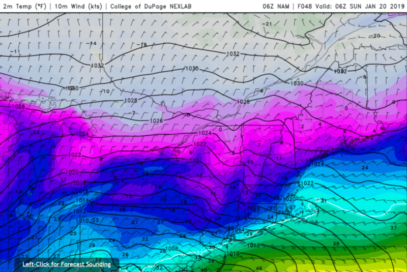
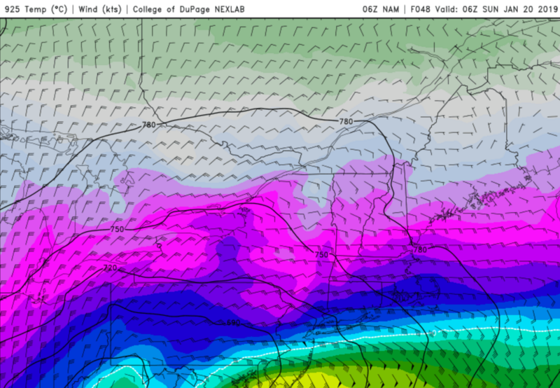
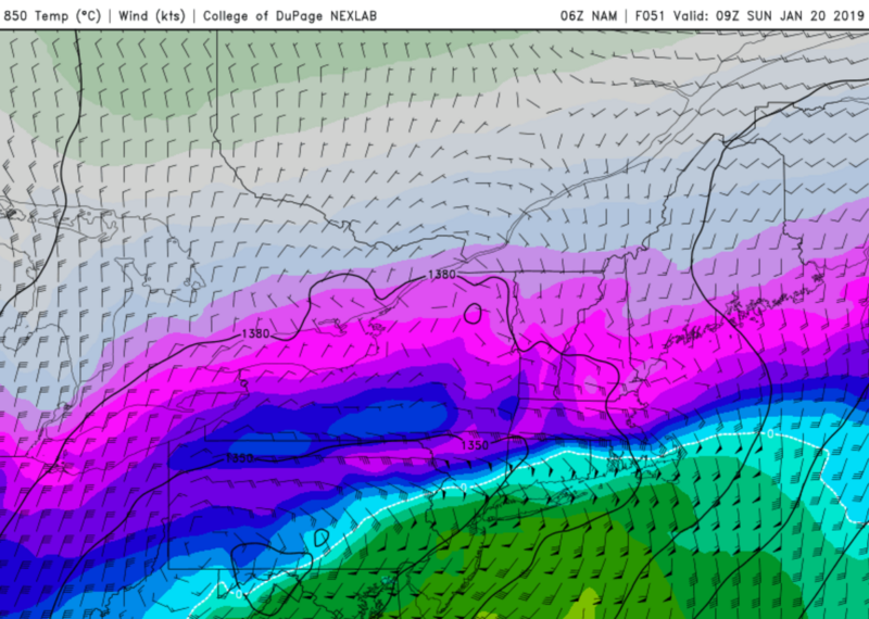
With marginal surface temps and 850mb temps above freezing - central NJ has changed over from snow to sleet/mix. NYC and the south shore of LI are literally on the line. Most likely, these areas are still all snow but its only a matter of time, maybe 1am, when the changeover occurs. Everyone else is all snow.
3am Sunday
850mb temps
925mb temps
Surface temps
At this point 850mb temps have warmed considerably for the entire area. Far NW NJ, SW NY, and NEPA are the only places that are snowing at this point in time. I think the call out here is the places where surface temps are in the mid-20's, 850's are above freezing, and 925mb is below freezing, you are susceptible to ice accretion. This would be NNJ (away from NYC), SNY and much of CT. Much of eastern/southern NJ, NYC, and LI are a very cold rain at this point on the NAM.
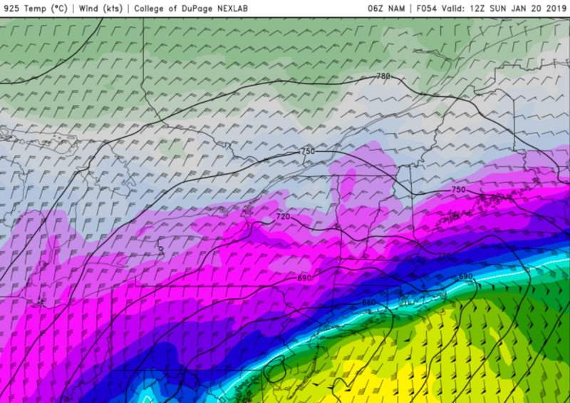
6am Sunday
850mb temps
925mb temps
Surface temps
Not a whole lot changes between 3am and 6am. 925mb warming even further might be the biggest one.
If you take this run of the NAM verbatim it has definitely trended snowier for those well N&W of NYC and reintroduces ice back into the picture for parts of the Metro area, likely JUST N&W of NYC. The areas I outlined above. If there is a continued shift S&E the ice/snow threat could become an issue for NYC and areas near the coast. Right now, this is actually one of the coldest models as others are much warmer. But I'm just trying to highlight the impact if this came to fruition.
NEPA, NW NJ, SWNY - areas who stay all snow - saw over 12 inches of snow verbatim this run.
_________________
_______________________________________________________________________________________________________
CLICK HERE to view NJ Strong Snowstorm Classifications

Frank_Wx- Godzilla Seeker
- Posts : 21305
Reputation : 328
Join date : 2013-01-05
Age : 31
Location : Jersey City, NJ -

Re: January 19th-20th: 1st Call Snow Map
![]() by Guest Fri Jan 18, 2019 8:32 am
by Guest Fri Jan 18, 2019 8:32 am
Guest- Guest
Re: January 19th-20th: 1st Call Snow Map
![]() by CPcantmeasuresnow Fri Jan 18, 2019 8:34 am
by CPcantmeasuresnow Fri Jan 18, 2019 8:34 am
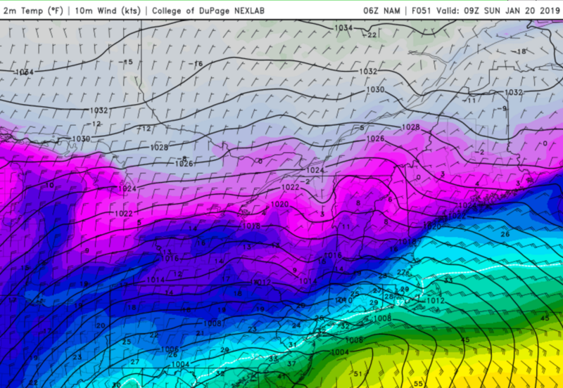
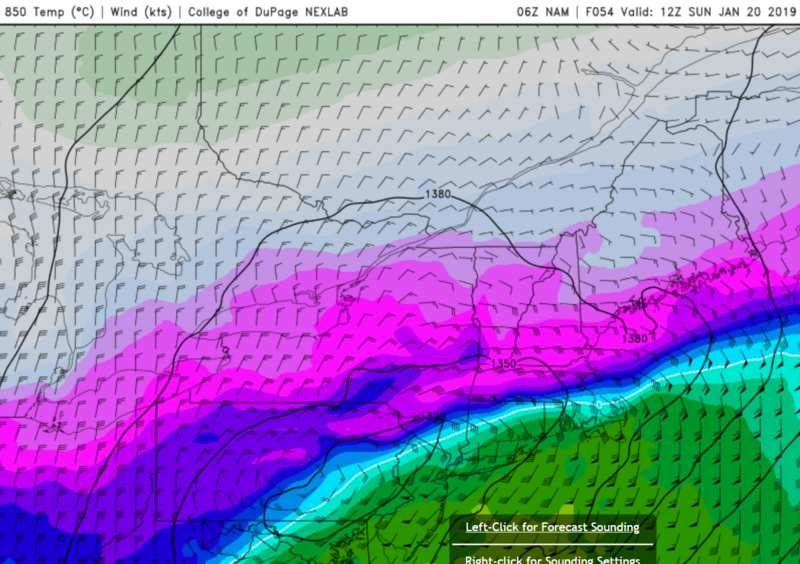
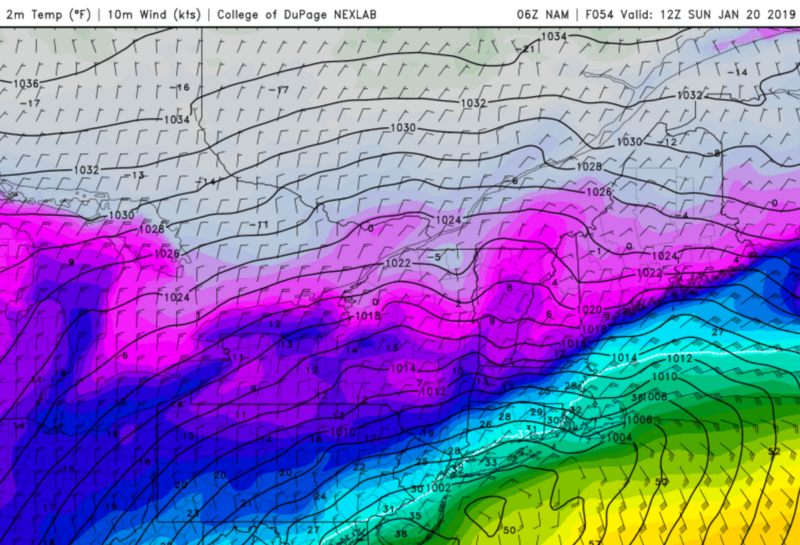
Frank_Wx wrote:The 06z NAM shows snow beginning between 5-6pm Saturday and lasting until 9-10pm before it tries to changeover to either a wintry mix or rain. Here is a look at some temperatures on frames when the changeover tries to occur and precip is coming down quite heavily.
Midnight Sunday
850mb temps
925mb temps
Surface temps
With marginal surface temps and 850mb temps above freezing - central NJ has changed over from snow to sleet/mix. NYC and the south shore of LI are literally on the line. Most likely, these areas are still all snow but its only a matter of time, maybe 1am, when the changeover occurs. Everyone else is all snow.
3am Sunday
850mb temps
925mb temps
Surface temps
At this point 850mb temps have warmed considerably for the entire area. Far NW NJ, SW NY, and NEPA are the only places that are snowing at this point in time. I think the call out here is the places where surface temps are in the mid-20's, 850's are above freezing, and 925mb is below freezing, you are susceptible to ice accretion. This would be NNJ (away from NYC), SNY and much of CT. Much of eastern/southern NJ, NYC, and LI are a very cold rain at this point on the NAM.
6am Sunday
850mb temps
925mb temps
Surface temps
Not a whole lot changes between 3am and 6am. 925mb warming even further might be the biggest one.
If you take this run of the NAM verbatim it has definitely trended snowier for those well N&W of NYC and reintroduces ice back into the picture for parts of the Metro area, likely JUST N&W of NYC. The areas I outlined above. If there is a continued shift S&E the ice/snow threat could become an issue for NYC and areas near the coast. Right now, this is actually one of the coldest models as others are much warmer. But I'm just trying to highlight the impact if this came to fruition.
NEPA, NW NJ, SWNY - areas who stay all snow - saw over 12 inches of snow verbatim this run.
Thanks Frank great graphics.
In a couple of places here you reference SWNY (southwest NY) where I think you mean SENY (southeast NY). Our only member in SWNY that I know of is the Aresian.

CPcantmeasuresnow- Wx Statistician Guru
- Posts : 7274
Reputation : 230
Join date : 2013-01-07
Age : 103
Location : Eastern Orange County, NY
Re: January 19th-20th: 1st Call Snow Map
![]() by Frank_Wx Fri Jan 18, 2019 8:36 am
by Frank_Wx Fri Jan 18, 2019 8:36 am
_________________
_______________________________________________________________________________________________________
CLICK HERE to view NJ Strong Snowstorm Classifications
Frank_Wx- Godzilla Seeker
- Posts : 21305
Reputation : 328
Join date : 2013-01-05
Age : 31
Location : Jersey City, NJ -
Re: January 19th-20th: 1st Call Snow Map
![]() by heehaw453 Fri Jan 18, 2019 8:44 am
by heehaw453 Fri Jan 18, 2019 8:44 am
heehaw453- Advanced Forecaster

- Posts : 3904
Reputation : 86
Join date : 2014-01-20
Location : Bedminster Township, PA Elevation 600' ASL
Re: January 19th-20th: 1st Call Snow Map
![]() by jmanley32 Fri Jan 18, 2019 8:57 am
by jmanley32 Fri Jan 18, 2019 8:57 am
jmanley32- Senior Enthusiast
- Posts : 20512
Reputation : 108
Join date : 2013-12-12
Age : 42
Location : Yonkers, NY
Re: January 19th-20th: 1st Call Snow Map
![]() by Guest Fri Jan 18, 2019 9:15 am
by Guest Fri Jan 18, 2019 9:15 am
Guest- Guest
Page 4 of 18 • 1, 2, 3, 4, 5 ... 11 ... 18 ![]()
|
|
|