Snow Events Week of 02/17
+31
weatherwatchermom
Math23x7
sroc4
RJB8525
jmanley32
1190ftalt
Grselig
Radz
docstox12
brownie
Artechmetals
lglickman1
frank 638
Dunnzoo
Vinnydula
SoulSingMG
Taffy
CPcantmeasuresnow
billg315
dkodgis
jimv45
Snow88
SENJsnowman
Irish
aiannone
algae888
rb924119
hyde345
heehaw453
amugs
Frank_Wx
35 posters
Page 1 of 7 • 1, 2, 3, 4, 5, 6, 7 
 Snow Events Week of 02/17
Buona Sera!
Figured I'll do something a little different and start a thread for the minor storm events next week. Especially since it seems models are going back and forth from all rain or a few inches of snow.
The NAM was consistently showing 2-3 inches of snow Sunday night UNTIL tonight. Now it shows virtually nothing for CNJ southward and a C-2 inches everywhere else. Why? Cause as mentioned earlier the primary low hangs on earlier.

Right now my thinking is a coating to 1 inch of snow Sunday night. Another nuisance.
Then we move onto Wednesday which looks like a solid event. Potentially 2 to 4 inches (sad that is considered solid, right?). But some models show as much as 6 inches so lets see. However, a changeover to mix then rain is also likely. So its the same sad story but the front end thump could be good and very little rain could fall.

My forecast here is 2 to 4 inches beginning Wednesday afternoon. I'll update this thread with the latest and greatest. Back to eating PB&J (check banter thread to see why I'm eating PB&J samiches).
Buonanotte raggazi
Figured I'll do something a little different and start a thread for the minor storm events next week. Especially since it seems models are going back and forth from all rain or a few inches of snow.
The NAM was consistently showing 2-3 inches of snow Sunday night UNTIL tonight. Now it shows virtually nothing for CNJ southward and a C-2 inches everywhere else. Why? Cause as mentioned earlier the primary low hangs on earlier.

Right now my thinking is a coating to 1 inch of snow Sunday night. Another nuisance.
Then we move onto Wednesday which looks like a solid event. Potentially 2 to 4 inches (sad that is considered solid, right?). But some models show as much as 6 inches so lets see. However, a changeover to mix then rain is also likely. So its the same sad story but the front end thump could be good and very little rain could fall.

My forecast here is 2 to 4 inches beginning Wednesday afternoon. I'll update this thread with the latest and greatest. Back to eating PB&J (check banter thread to see why I'm eating PB&J samiches).
Buonanotte raggazi
_________________
_______________________________________________________________________________________________________
CLICK HERE to view NJ Strong Snowstorm Classifications
 Re: Snow Events Week of 02/17
Oops, I failed to mention ANOTHER snow to rain event is possible next Saturday too. So, a busy week of tracking. I wish it were Godzilla or Roidzillas though. Not these turds.
Ok...bene? Ciao
Ok...bene? Ciao
_________________
_______________________________________________________________________________________________________
CLICK HERE to view NJ Strong Snowstorm Classifications
 Re: Snow Events Week of 02/17
Your Godzilla will come once we get the THP to reverse and the Azores HP to disconnect from the NATL.
Looks to be last days of Feb and first days of March IF it holds true on this.
For now we get what we get and we don't get upset.
3K NAM came in colder. GFS is about the same

OZ

Looks to be last days of Feb and first days of March IF it holds true on this.
For now we get what we get and we don't get upset.
3K NAM came in colder. GFS is about the same

OZ

_________________
Mugs
AKA:King: Snow Weenie
Self Proclaimed
WINTER 2014-15 : 55.12" +.02 for 6 coatings (avg. 35")
WINTER 2015-16 Total - 29.8" (Avg 35")
WINTER 2016-17 : 39.5" so far

amugs- Advanced Forecaster - Mod

- Posts : 15091
Reputation : 213
Join date : 2013-01-07
Age : 54
Location : Hillsdale,NJ
 Re: Snow Events Week of 02/17
C-2” Sunday night. SNE probably is 2-4”. Storm transfers too late most likely. But maybe LI and HV can get a surprise with this too.
The Wednesday threat took a step back last night. I know shocker. Dry air eats away at the snow initially. Thermals look fine. This can still be ok for us as I think there’s a good jet for lifting and good moisture.
The Wednesday threat took a step back last night. I know shocker. Dry air eats away at the snow initially. Thermals look fine. This can still be ok for us as I think there’s a good jet for lifting and good moisture.
heehaw453- Advanced Forecaster

- Posts : 3904
Reputation : 86
Join date : 2014-01-20
Location : Bedminster Township, PA Elevation 600' ASL
 Re: Snow Events Week of 02/17
Yes kind of a catch 22 here you need the CAD but it will take away from the snow totals if you want snow in this set up or we just rain.heehaw453 wrote:C-2” Sunday night. SNE probably is 2-4”. Storm transfers too late most likely. But maybe LI and HV can get a surprise with this too.
The Wednesday threat took a step back last night. I know shocker. Dry air eats away at the snow initially. Thermals look fine. This can still be ok for us as I think there’s a good jet for lifting and good moisture.
6Z GFS holds with snow totals

_________________
Mugs
AKA:King: Snow Weenie
Self Proclaimed
WINTER 2014-15 : 55.12" +.02 for 6 coatings (avg. 35")
WINTER 2015-16 Total - 29.8" (Avg 35")
WINTER 2016-17 : 39.5" so far

amugs- Advanced Forecaster - Mod

- Posts : 15091
Reputation : 213
Join date : 2013-01-07
Age : 54
Location : Hillsdale,NJ
 Re: Snow Events Week of 02/17
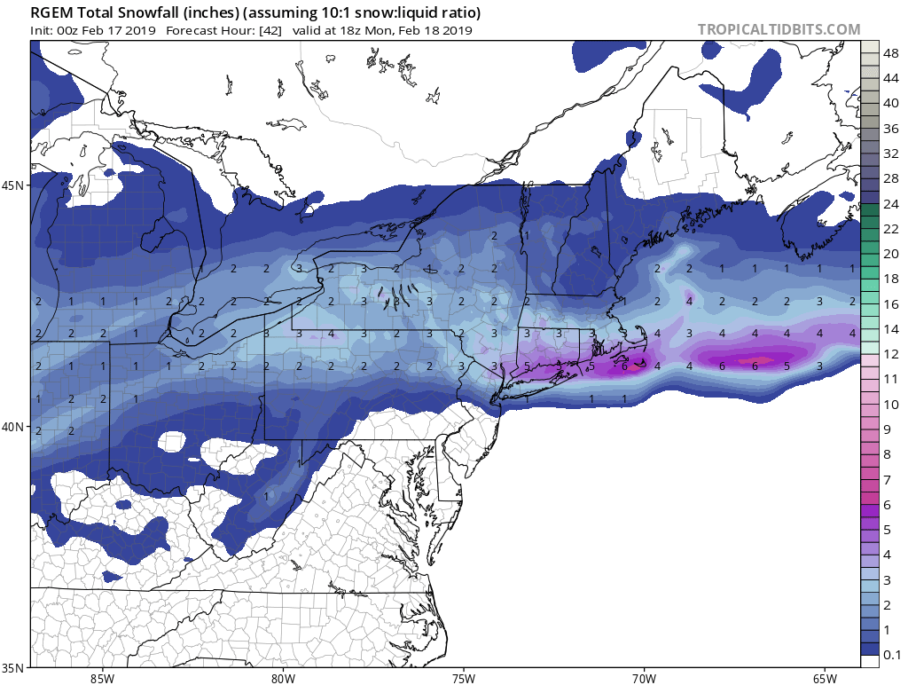
RGEM and NAM take the primary into Pitt
RGEM gives us a 1-3" NAM is more sleet and ZR in its 1"-4" range.
Whatever the case well see wintry precipitation tomorrow night into Monday morning
RGEM gives us a 1-3" NAM is more sleet and ZR in its 1"-4" range.
Whatever the case well see wintry precipitation tomorrow night into Monday morning
_________________
Mugs
AKA:King: Snow Weenie
Self Proclaimed
WINTER 2014-15 : 55.12" +.02 for 6 coatings (avg. 35")
WINTER 2015-16 Total - 29.8" (Avg 35")
WINTER 2016-17 : 39.5" so far

amugs- Advanced Forecaster - Mod

- Posts : 15091
Reputation : 213
Join date : 2013-01-07
Age : 54
Location : Hillsdale,NJ
 Re: Snow Events Week of 02/17
Looking to pick up 6 inches from the 2 events up here. Thermal profiles will again be tricky especially in NYC metro.

hyde345- Pro Enthusiast

- Posts : 1082
Reputation : 48
Join date : 2013-01-08
Location : Hyde Park, NY
 Re: Snow Events Week of 02/17
hyde345 wrote:Looking to pick up 6 inches from the 2 events up here. Thermal profiles will again be tricky especially in NYC metro.
I think half of this is more realistic lol then again, it never hurts to stay positive
rb924119- Meteorologist

- Posts : 6888
Reputation : 194
Join date : 2013-02-06
Age : 32
Location : Greentown, Pa
 Re: Snow Events Week of 02/17
rb924119 wrote:hyde345 wrote:Looking to pick up 6 inches from the 2 events up here. Thermal profiles will again be tricky especially in NYC metro.
I think half of this is more realistic lol then again, it never hurts to stay positive
I meant six inches combined, not from each event.

hyde345- Pro Enthusiast

- Posts : 1082
Reputation : 48
Join date : 2013-01-08
Location : Hyde Park, NY
 Re: Snow Events Week of 02/17
hyde345 wrote:rb924119 wrote:hyde345 wrote:Looking to pick up 6 inches from the 2 events up here. Thermal profiles will again be tricky especially in NYC metro.
I think half of this is more realistic lol then again, it never hurts to stay positive
I meant six inches combined, not from each event.
I know, but my opinion still stands lmao
rb924119- Meteorologist

- Posts : 6888
Reputation : 194
Join date : 2013-02-06
Age : 32
Location : Greentown, Pa
 Re: Snow Events Week of 02/17
rb924119 wrote:hyde345 wrote:rb924119 wrote:hyde345 wrote:Looking to pick up 6 inches from the 2 events up here. Thermal profiles will again be tricky especially in NYC metro.
I think half of this is more realistic lol then again, it never hurts to stay positive
I meant six inches combined, not from each event.
I know, but my opinion still stands lmao
You're probably right especially when it comes to Wednesday's threat. Sunday night threat could surprise LI and HV IMO and drop several inches.
I was hoping for a front end thump on Wednesday and have always realized the SE ridge will taint the precip, but guidance is really downplaying the front end now. This would probably mean a few inches and then some slop. It is what it is LOL!
heehaw453- Advanced Forecaster

- Posts : 3904
Reputation : 86
Join date : 2014-01-20
Location : Bedminster Township, PA Elevation 600' ASL
 Re: Snow Events Week of 02/17
The problems I see with this event are the following:
1. Forcing mechanisms are completely disjointed. There is zero jet support for this system. H5 PVA is maximized across west-central NY before decaying as it rapidly shears out. This is also colocated with weak isentropic/low-level FGEN. Further east toward the I-95 Corridor, you have substantially enhanced isentropic lift through the lower levels near and east of the region, but nearly non-existent mid-level forcing. This is going to lead to a rather large area of extremely light and/or non-existent precipitation between the areas of forcing, which happens to be across much of our board area. Secondly, because the overall flow is zonal and fast, and the mid-levels are deamplifying, the coastal will not blossom. It will likely end up as a sheared out linear wave of precipitation along the isentropic and frontal forcing, with little to no enhancement along its northwestern periphery.
2. Duration. This will not be a long-lived system when looking at the duration of *meaningful* precipitation rates given the zonal and fast nature of the overall streamflow.
3. Tying in with the above, you do not have significant overlap of cold enough air and moisture. If you get the moisture, it’s likely to be more wet than white, and vice versa. Therefore, snowfall rates will likely be less than noteable during much of the event. Based on the hemispheric and tropical modes, I believe this ends up verifying warmer overall than currently progged. We will get the moisture, but it will be mostly liquid or mixed.
4. Thermal profile. While the overall column would be supportive of dendrite growth, the lack of adequate forcing throughout the column leads to me believe that crystal habits will not follow the thermal/saturation rules. Therefore, this will act to further limit accumulations.
Just some quick thoughts of mine. I think the overall presentation of the 18z HRDPS looked reasonable, though too much snow for LI and SNE.
rb924119- Meteorologist

- Posts : 6888
Reputation : 194
Join date : 2013-02-06
Age : 32
Location : Greentown, Pa
 Re: Snow Events Week of 02/17
rb924119 wrote:The problems I see with this event are the following:
1. Forcing mechanisms are completely disjointed. There is zero jet support for this system. H5 PVA is maximized across west-central NY before decaying as it rapidly shears out. This is also colocated with weak isentropic/low-level FGEN. Further east toward the I-95 Corridor, you have substantially enhanced isentropic lift through the lower levels near and east of the region, but nearly non-existent mid-level forcing. This is going to lead to a rather large area of extremely light and/or non-existent precipitation between the areas of forcing, which happens to be across much of our board area. Secondly, because the overall flow is zonal and fast, and the mid-levels are deamplifying, the coastal will not blossom. It will likely end up as a sheared out linear wave of precipitation along the isentropic and frontal forcing, with little to no enhancement along its northwestern periphery.
2. Duration. This will not be a long-lived system when looking at the duration of *meaningful* precipitation rates given the zonal and fast nature of the overall streamflow.
3. Tying in with the above, you do not have significant overlap of cold enough air and moisture. If you get the moisture, it’s likely to be more wet than white, and vice versa. Therefore, snowfall rates will likely be less than noteable during much of the event. Based on the hemispheric and tropical modes, I believe this ends up verifying warmer overall than currently progged. We will get the moisture, but it will be mostly liquid or mixed.
4. Thermal profile. While the overall column would be supportive of dendrite growth, the lack of adequate forcing throughout the column leads to me believe that crystal habits will not follow the thermal/saturation rules. Therefore, this will act to further limit accumulations.
Just some quick thoughts of mine. I think the overall presentation of the 18z HRDPS looked reasonable, though too much snow for LI and SNE.
Really? The HRDPS? It shows about 20 different surface lows.

hyde345- Pro Enthusiast

- Posts : 1082
Reputation : 48
Join date : 2013-01-08
Location : Hyde Park, NY
 Re: Snow Events Week of 02/17
hyde345 wrote:rb924119 wrote:The problems I see with this event are the following:
1. Forcing mechanisms are completely disjointed. There is zero jet support for this system. H5 PVA is maximized across west-central NY before decaying as it rapidly shears out. This is also colocated with weak isentropic/low-level FGEN. Further east toward the I-95 Corridor, you have substantially enhanced isentropic lift through the lower levels near and east of the region, but nearly non-existent mid-level forcing. This is going to lead to a rather large area of extremely light and/or non-existent precipitation between the areas of forcing, which happens to be across much of our board area. Secondly, because the overall flow is zonal and fast, and the mid-levels are deamplifying, the coastal will not blossom. It will likely end up as a sheared out linear wave of precipitation along the isentropic and frontal forcing, with little to no enhancement along its northwestern periphery.
2. Duration. This will not be a long-lived system when looking at the duration of *meaningful* precipitation rates given the zonal and fast nature of the overall streamflow.
3. Tying in with the above, you do not have significant overlap of cold enough air and moisture. If you get the moisture, it’s likely to be more wet than white, and vice versa. Therefore, snowfall rates will likely be less than noteable during much of the event. Based on the hemispheric and tropical modes, I believe this ends up verifying warmer overall than currently progged. We will get the moisture, but it will be mostly liquid or mixed.
4. Thermal profile. While the overall column would be supportive of dendrite growth, the lack of adequate forcing throughout the column leads to me believe that crystal habits will not follow the thermal/saturation rules. Therefore, this will act to further limit accumulations.
Just some quick thoughts of mine. I think the overall presentation of the 18z HRDPS looked reasonable, though too much snow for LI and SNE.
Really? The HRDPS? It shows about 20 different surface lows.
You can ignore all that; it’s just display error, as evidenced by the gridlike appearance. The fundamental output is fine haha it does look pretty funny, though lmao
rb924119- Meteorologist

- Posts : 6888
Reputation : 194
Join date : 2013-02-06
Age : 32
Location : Greentown, Pa
 Re: Snow Events Week of 02/17
0Z 12k NAM shows general 2-4” across most of northern areas 78 on north. I continue to notice a bit colder and wintry precipitation further south across most guidance. If a slightly earlier transfer then it’s a new ball game for most. Keep my expectations low now though.
heehaw453- Advanced Forecaster

- Posts : 3904
Reputation : 86
Join date : 2014-01-20
Location : Bedminster Township, PA Elevation 600' ASL
 Re: Snow Events Week of 02/17
heehaw453 wrote:0Z 12k NAM shows general 2-4” across most of northern areas 78 on north. I continue to notice a bit colder and wintry precipitation further south across most guidance. If a slightly earlier transfer then it’s a new ball game for most. Keep my expectations low now though.
Nam definitely is juiced. Gives my area 4-6. We shall see.

hyde345- Pro Enthusiast

- Posts : 1082
Reputation : 48
Join date : 2013-01-08
Location : Hyde Park, NY
 Re: Snow Events Week of 02/17
hyde345 wrote:heehaw453 wrote:0Z 12k NAM shows general 2-4” across most of northern areas 78 on north. I continue to notice a bit colder and wintry precipitation further south across most guidance. If a slightly earlier transfer then it’s a new ball game for most. Keep my expectations low now though.
Nam definitely is juiced. Gives my area 4-6. We shall see.
It wouldn’t shock me honestly. The HV folks may do quite well.
heehaw453- Advanced Forecaster

- Posts : 3904
Reputation : 86
Join date : 2014-01-20
Location : Bedminster Township, PA Elevation 600' ASL
 Re: Snow Events Week of 02/17
That's a potent shortwave with the Gulf of Mexico moisture to work with. A lot of times the models will sheer them out to fast. latest nam and rgem n Euro at 18z increased moisture with this system. this is going to surprise a lot of people

algae888- Advanced Forecaster

- Posts : 5311
Reputation : 46
Join date : 2013-02-05
Age : 61
Location : mt. vernon, new york
 Re: Snow Events Week of 02/17
Little worried about temps for NYC/LI. But I think there is a chance it’s a mostly snow event that maybe ends as a little light rain.
_________________
-Alex Iannone-

aiannone- Senior Enthusiast - Mod

- Posts : 4813
Reputation : 92
Join date : 2013-01-07
Location : Saint James, LI (Northwest Suffolk Co.)
 Re: Snow Events Week of 02/17
_________________
Mugs
AKA:King: Snow Weenie
Self Proclaimed
WINTER 2014-15 : 55.12" +.02 for 6 coatings (avg. 35")
WINTER 2015-16 Total - 29.8" (Avg 35")
WINTER 2016-17 : 39.5" so far

amugs- Advanced Forecaster - Mod

- Posts : 15091
Reputation : 213
Join date : 2013-01-07
Age : 54
Location : Hillsdale,NJ
 Re: Snow Events Week of 02/17
Yeah, i'm not even looking at sunday into Monday, as there won't be much at all for my area. i'm just moving onto the wednesday storm hoping for something more.

Irish- Pro Enthusiast

- Posts : 788
Reputation : 19
Join date : 2019-01-16
Age : 45
Location : Old Bridge, NJ
 Re: Snow Events Week of 02/17
As for tonight's event, it looks like only perhaps the southern tier of NY State is in a good position to exceed an inch or two. WLHV looks to do better than ELHV. And other wise, the snow will not enter the NYC metro, New Jersey or EPA at any cost. Not the result you would hope for with a LP sitting right on top of the bm.

As for the mid-week threat, not looking much better. I think it was Algae who mentioned the perfect high pressure blocking to north:

And now, that high has moved into just as terrible of a position for us (and one that I've never seen before actually):

The latest Nam stops here, but it's clearly the same result:

Looking like more of the same...

As for the mid-week threat, not looking much better. I think it was Algae who mentioned the perfect high pressure blocking to north:

And now, that high has moved into just as terrible of a position for us (and one that I've never seen before actually):

The latest Nam stops here, but it's clearly the same result:

Looking like more of the same...
SENJsnowman- Senior Enthusiast

- Posts : 1186
Reputation : 61
Join date : 2017-01-06
Age : 51
Location : Bayville, NJ
 Re: Snow Events Week of 02/17
Nam is colder for the NYC area. Snow to rain.
The Nam and the latest Euro has a quicker arrival for the precip on Wednesday.
The Nam and the latest Euro has a quicker arrival for the precip on Wednesday.

Snow88- Senior Enthusiast

- Posts : 2193
Reputation : 4
Join date : 2013-01-09
Age : 35
Location : Brooklyn, NY
 Re: Snow Events Week of 02/17
The 12Z NAM would be a 4-6” thump of snow on Wednesday along and NW of 95 before tainting. Probably never getting above freezing NW of 95.
heehaw453- Advanced Forecaster

- Posts : 3904
Reputation : 86
Join date : 2014-01-20
Location : Bedminster Township, PA Elevation 600' ASL

hyde345- Pro Enthusiast

- Posts : 1082
Reputation : 48
Join date : 2013-01-08
Location : Hyde Park, NY
Page 1 of 7 • 1, 2, 3, 4, 5, 6, 7 
Permissions in this forum:
You cannot reply to topics in this forum|
|
|

 Home
Home
