
 Search
Long Range Thread 19.0
Page 4 of 28 •  1, 2, 3, 4, 5 ... 16 ... 28
 ![]()
Re: Long Range Thread 19.0
![]() by sroc4 Fri Nov 22, 2019 7:54 am
by sroc4 Fri Nov 22, 2019 7:54 am
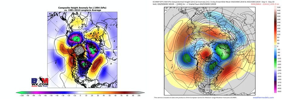
The strat is forecast to shift to the other side of the N hemisphere for a bit. Whenever that happens it typically offers resistance in the troposphere for the 500mb to hit and hold with the polar/arctic air dep into the Eastern CONUS.

Here are the image for the strat vortex mean positioning for the month of Nov through the 18th, the resultant 500mb mean trough ridge orientation, and the mean 2m temps as a result. You can clearly see the correlation.


The other part is the MJO wave. It originally had it crashing into the COD after this phase 8 propagation and recirculate back into favorable phases; however, if you have been watching the trends this MJO wave continues into less favorable phases and slows.
Looking at the means in the EPS and GEFS ensembles respectively you can see there is a fundamental difference in the depiction of where the mean trough ridge axis will be in the longer range again specifically what is related to the Pac side of things. Notice the axis of the mean ridge trough axis between the two.


Unfortunatly for now I just dont agree with the GEFS depiction of what we are seeing headed into Dec. because it doesn't agree with the the forcing mechanisms coming out of the Pac and what the strat is attempting to do ATT. Like you said in the post I accidently deleted IF this aspect of the modeling is correct. Time will tell and I hope Im wrong but its how I see it now. This -NAO that is happening may end up all for not, or perhaps be just enough to offer up a few "chances" that may even come to fruition, but again the overall big picture to me doesnt look ready.
Last edited by sroc4 on Wed Dec 04, 2019 6:26 am; edited 1 time in total
sroc4- Admin

- Posts : 8331
Join date : 2013-01-07
Re: Long Range Thread 19.0
![]() by Frank_Wx Sat Nov 23, 2019 8:00 pm
by Frank_Wx Sat Nov 23, 2019 8:00 pm

As doc alluded the ridge is displaced too far west so the pattern for us would feature something like cold, cutter, cold. A cutter, as you know, is a storm that 'cuts' or tracks well inland flooding us with mild temps.
Now...our hope is the -NAO. If this feature stays relevant one week from now then there is a chance it prevents a cutter and actually forms some type of coastal / miller-B system. December 2nd-3rd is the time frame to watch. And if that does not work out we have another shot near the 6th-8th.

Frank_Wx- Godzilla Seeker
- Posts : 21305
Join date : 2013-01-05 -

Re: Long Range Thread 19.0
![]() by Math23x7 Sun Nov 24, 2019 2:13 pm
by Math23x7 Sun Nov 24, 2019 2:13 pm

As shown, the fact the -EPO ridge was too far west meant the trough was on the West Coast of North America, which does not bode well for snow along I-95.
Now, let's take a look at what the upper level features look like, first at the teleconnections:

The PNA is mainly negative and the NAO, which at the moment is negative, looks to shoot positive going forward. The EPO is consistently negative throughout the next two weeks. However, when we look at the 500 mb pattern at the end of the Ensemble GFS run, you can see where the ridge is located:

Yes, it's west of Hawaii, around the Aleutian islands. And you can also see the west coast trough and the below normal heights over Greenland. Not a great look for winter weather along I-95.
Now, if there is a window between now and then, it's next week as there looks to be a temporary trough in the East:

It should be noted though that while there are above normal heights over Western Canada, the ridge is centered over the Aleutian Islands, much like it is a week later.
Now, can the ensemble GFS be wrong going into December and can I-95 end up cold/snowy during the month? Perhaps. But these features that I see on the long range are not ones I like to see.
Math23x7- Wx Statistician Guru

- Posts : 2379
Reputation : 68
Join date : 2013-01-08
Re: Long Range Thread 19.0
![]() by amugs Sun Nov 24, 2019 3:38 pm
by amugs Sun Nov 24, 2019 3:38 pm
Also, we have to see what the MJO pahses are and what the VP maps are showing in the tropical Pac, IO oceans.
The alley seems to be to our west for now and this is typical for Nov and later fall.
Time will tell.
_________________
Mugs
AKA:King: Snow Weenie
Self Proclaimed
WINTER 2014-15 : 55.12" +.02 for 6 coatings (avg. 35")
WINTER 2015-16 Total - 29.8" (Avg 35")
WINTER 2016-17 : 39.5" so far

amugs- Advanced Forecaster - Mod

- Posts : 15091
Reputation : 213
Join date : 2013-01-07
Age : 54
Location : Hillsdale,NJ
Re: Long Range Thread 19.0
![]() by Frank_Wx Mon Nov 25, 2019 12:57 pm
by Frank_Wx Mon Nov 25, 2019 12:57 pm

_________________
_______________________________________________________________________________________________________
CLICK HERE to view NJ Strong Snowstorm Classifications

Frank_Wx- Godzilla Seeker
- Posts : 21305
Reputation : 328
Join date : 2013-01-05
Age : 31
Location : Jersey City, NJ -
Re: Long Range Thread 19.0
![]() by sroc4 Mon Nov 25, 2019 1:23 pm
by sroc4 Mon Nov 25, 2019 1:23 pm
Frank_Wx wrote:An extremely delicate situation unfolding early next week. You will notice the 500mb trough is closed off and already tilting negative on Sunday, and the western ridge is slipping east, but a psuedo 50-50 Low and -NAO could turn this into our first significant winter weather event of the season.
The mid week storm will play an integral part in clogging things up. The block over Greenland is in the process of breaking down as we head through the weekend but combined with the possibilities of a 50/50 low a transfer far enough south is possible. All the while a Rex block is setting up along the WC of NA.
_________________
"In weather and in life, there's no winning and losing; there's only winning and learning."
WINTER 2012/2013 TOTALS 43.65"WINTER 2017/2018 TOTALS 62.85" WINTER 2022/2023 TOTALS 4.9"
WINTER 2013/2014 TOTALS 64.85"WINTER 2018/2019 TOTALS 14.25" WINTER 2023/2024 TOTALS 13.1"
WINTER 2014/2015 TOTALS 71.20"WINTER 2019/2020 TOTALS 6.35"
WINTER 2015/2016 TOTALS 35.00"WINTER 2020/2021 TOTALS 37.75"
WINTER 2016/2017 TOTALS 42.25"WINTER 2021/2022 TOTALS 31.65"

sroc4- Admin
- Posts : 8331
Reputation : 301
Join date : 2013-01-07
Location : Wading River, LI
Re: Long Range Thread 19.0
![]() by algae888 Mon Nov 25, 2019 2:08 pm
by algae888 Mon Nov 25, 2019 2:08 pm

algae888- Advanced Forecaster

- Posts : 5311
Reputation : 46
Join date : 2013-02-05
Age : 61
Location : mt. vernon, new york
Re: Long Range Thread 19.0
![]() by Frank_Wx Mon Nov 25, 2019 2:12 pm
by Frank_Wx Mon Nov 25, 2019 2:12 pm

Long way to go but nice to see the signal. Question will be does the transfer trend faster, meaning a low developing off the coast further south prompting more cold air? OR does the trend go the other direction or stay where it is with a late transfer, the coastal low developing too late and warm air penetrating across the boundaries?
It will depend on the -NAO/50-50 block for the most part!!!
_________________
_______________________________________________________________________________________________________
CLICK HERE to view NJ Strong Snowstorm Classifications
Frank_Wx- Godzilla Seeker
- Posts : 21305
Reputation : 328
Join date : 2013-01-05
Age : 31
Location : Jersey City, NJ -
Re: Long Range Thread 19.0
![]() by algae888 Mon Nov 25, 2019 3:18 pm
by algae888 Mon Nov 25, 2019 3:18 pm
The 50/50 low definitely trended stronger on today's 12z eps also to math AKA Mike who now lives in Albany did you look at today's GEFS for the same time frame you posted yesterday? Well it now has an Aleutian low and a positive PNA extending from the West Coast all the way into Alaska and a trough in the east. EPS looks very similar at this time frame. The models are struggling mightily with the post 10-day pattern. My feeling is that they are struggling with the mjo which does not look to head into the warm phases anytime soon and is currently in the c o d looking to come out in one.Frank_Wx wrote:EURO similar to GFS
Long way to go but nice to see the signal. Question will be does the transfer trend faster, meaning a low developing off the coast further south prompting more cold air? OR does the trend go the other direction or stay where it is with a late transfer, the coastal low developing too late and warm air penetrating across the boundaries?
It will depend on the -NAO/50-50 block for the most part!!!
algae888- Advanced Forecaster
- Posts : 5311
Reputation : 46
Join date : 2013-02-05
Age : 61
Location : mt. vernon, new york
Re: Long Range Thread 19.0
![]() by jmanley32 Mon Nov 25, 2019 3:51 pm
by jmanley32 Mon Nov 25, 2019 3:51 pm

jmanley32- Senior Enthusiast

- Posts : 20512
Reputation : 108
Join date : 2013-12-12
Age : 42
Location : Yonkers, NY
Re: Long Range Thread 19.0
![]() by jmanley32 Mon Nov 25, 2019 3:53 pm
by jmanley32 Mon Nov 25, 2019 3:53 pm
jmanley32- Senior Enthusiast
- Posts : 20512
Reputation : 108
Join date : 2013-12-12
Age : 42
Location : Yonkers, NY
Re: Long Range Thread 19.0
![]() by heehaw453 Tue Nov 26, 2019 4:54 am
by heehaw453 Tue Nov 26, 2019 4:54 am

heehaw453- Advanced Forecaster
- Posts : 3904
Reputation : 86
Join date : 2014-01-20
Location : Bedminster Township, PA Elevation 600' ASL
Re: Long Range Thread 19.0
![]() by skinsfan1177 Tue Nov 26, 2019 5:16 am
by skinsfan1177 Tue Nov 26, 2019 5:16 am
heehaw453 wrote:Definitely something to keep our eye on. The mid-week storm seems to be influenced by the NAO blocking and the weekend storm influenced by the aforementioned stalled out low, at least as modeled. As sroc pointed out we should know more after midweek storm sets up in mid latitudes to know more about where the transfer occurs and how stuck the weekend storm becomes. That is probably the key.
Some models overnight showed precip falling a prolonged time 54-60hours. Also imo I think it can tick south some with the strong block in place often times models underestimate the strength of blocking

skinsfan1177- Senior Enthusiast
- Posts : 4485
Reputation : 35
Join date : 2013-01-07
Age : 46
Location : Point Pleasant Boro
Re: Long Range Thread 19.0
![]() by docstox12 Tue Nov 26, 2019 5:20 am
by docstox12 Tue Nov 26, 2019 5:20 am

docstox12- Wx Statistician Guru
- Posts : 8497
Reputation : 222
Join date : 2013-01-07
Age : 73
Location : Monroe NY
Re: Long Range Thread 19.0
![]() by Frank_Wx Tue Dec 03, 2019 1:10 pm
by Frank_Wx Tue Dec 03, 2019 1:10 pm
_________________
_______________________________________________________________________________________________________
CLICK HERE to view NJ Strong Snowstorm Classifications
Frank_Wx- Godzilla Seeker
- Posts : 21305
Reputation : 328
Join date : 2013-01-05
Age : 31
Location : Jersey City, NJ -
Re: Long Range Thread 19.0
![]() by algae888 Tue Dec 03, 2019 2:00 pm
by algae888 Tue Dec 03, 2019 2:00 pm
algae888- Advanced Forecaster
- Posts : 5311
Reputation : 46
Join date : 2013-02-05
Age : 61
Location : mt. vernon, new york
Re: Long Range Thread 19.0
![]() by amugs Wed Dec 04, 2019 10:16 am
by amugs Wed Dec 04, 2019 10:16 am
Look at the PNA in orange colors over the west coast that extend all the way up and over the arctic into the Greenland region. The deeper blue color over just south of Alaska is the Aleutian LP that will deepen and help pump this ridge. Deep trough develops in the Eastern portion of the CONUS.

_________________
Mugs
AKA:King: Snow Weenie
Self Proclaimed
WINTER 2014-15 : 55.12" +.02 for 6 coatings (avg. 35")
WINTER 2015-16 Total - 29.8" (Avg 35")
WINTER 2016-17 : 39.5" so far
amugs- Advanced Forecaster - Mod
- Posts : 15091
Reputation : 213
Join date : 2013-01-07
Age : 54
Location : Hillsdale,NJ
Re: Long Range Thread 19.0
![]() by billg315 Thu Dec 05, 2019 9:16 am
by billg315 Thu Dec 05, 2019 9:16 am

billg315- Advanced Forecaster - Mod
- Posts : 4461
Reputation : 185
Join date : 2015-01-24
Age : 50
Location : Flemington, NJ
Re: Long Range Thread 19.0
![]() by skinsfan1177 Thu Dec 05, 2019 9:31 am
by skinsfan1177 Thu Dec 05, 2019 9:31 am
skinsfan1177- Senior Enthusiast
- Posts : 4485
Reputation : 35
Join date : 2013-01-07
Age : 46
Location : Point Pleasant Boro
Re: Long Range Thread 19.0
![]() by amugs Thu Dec 05, 2019 10:53 am
by amugs Thu Dec 05, 2019 10:53 am
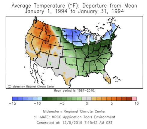
- I will sign giving the rest of my large intestines for a winter redux for this - this was a bomb of a winter with a gradient set up just to our south. We ran of space to put snow!!!
MLK Ice storm - back to back MECS, multiple over running events mostly snow, 9 days off from school, High Point tied the state low temp record of -34 set back in 1934 by River Vale. This is delicious and very exciting to see.
Why, we have low solar for one, two we have a PAC SST in Nino regions that are favorable for a phase 7,8,1,2,3 in the right months and we have positive juju!!!!
Here is the link to BAMWX tweet link
https://twitter.com/bamwxcom/status/1202580152523411460?s=20
_________________
Mugs
AKA:King: Snow Weenie
Self Proclaimed
WINTER 2014-15 : 55.12" +.02 for 6 coatings (avg. 35")
WINTER 2015-16 Total - 29.8" (Avg 35")
WINTER 2016-17 : 39.5" so far
amugs- Advanced Forecaster - Mod
- Posts : 15091
Reputation : 213
Join date : 2013-01-07
Age : 54
Location : Hillsdale,NJ
Re: Long Range Thread 19.0
![]() by amugs Thu Dec 05, 2019 10:54 am
by amugs Thu Dec 05, 2019 10:54 am
Look at how the N EPO gets reinforced

_________________
Mugs
AKA:King: Snow Weenie
Self Proclaimed
WINTER 2014-15 : 55.12" +.02 for 6 coatings (avg. 35")
WINTER 2015-16 Total - 29.8" (Avg 35")
WINTER 2016-17 : 39.5" so far
amugs- Advanced Forecaster - Mod
- Posts : 15091
Reputation : 213
Join date : 2013-01-07
Age : 54
Location : Hillsdale,NJ
Re: Long Range Thread 19.0
![]() by amugs Fri Dec 06, 2019 2:22 pm
by amugs Fri Dec 06, 2019 2:22 pm
_________________
Mugs
AKA:King: Snow Weenie
Self Proclaimed
WINTER 2014-15 : 55.12" +.02 for 6 coatings (avg. 35")
WINTER 2015-16 Total - 29.8" (Avg 35")
WINTER 2016-17 : 39.5" so far
amugs- Advanced Forecaster - Mod
- Posts : 15091
Reputation : 213
Join date : 2013-01-07
Age : 54
Location : Hillsdale,NJ
Re: Long Range Thread 19.0
![]() by rb924119 Fri Dec 06, 2019 2:27 pm
by rb924119 Fri Dec 06, 2019 2:27 pm
“No doubt your concerns are valid. But I can see how the system establishes its own pseudo-block here, similarly to our previous system. The hemispheric alignment, to me, supports phasing between the southern stream energy ejecting out of the Southwest and northern stream energy diving straight out of the high latitudes (which these are notoriously undermodeled in forward propagation and intensity *when high latitude blocking is present*, anecdotally in my experience, and in this case we will have as of now). However after this phasing process is underway, we lose the PNA ridging as energy starts coming ashore and damping the height field. Concomitantly, we have a second spoke coming down in response to the high latitude blocking, but at face value, this is what leads me to think that our system phasing in the Southeast might not cut. Because the PNA/EPO connection was severed by the energy coming into the Left Coast, that second spoke should start slipping eastward as its tendency to dig lessens. Simultaneously, our phasing system is working raise heights out ahead of it. Essentially, the race is on between the forward speed of the second northern stream spoke getting out ahead of our system, because if it can outrun it, it will work to enhance the confluence over the Northeast and put a lid on the northward progression of the system in the Southeast (hence the pseudo-blocking). The airmass may initially be tainted, especially for the coastal sections, but that confluence would force either a further east track of the primary, or a redevelopment off the coast with a slow forward propagation due to the closed off mid-/upper-levels, much like we just saw. So that fresh delivery of cold air by the second spoke would be waiting not too far away to be drawn in. HOWEVER, this would be coming out of the right direction for something big. I’m not sold on this evolution, but based on brief analysis, I’m more than intrigued by this possibility right now. Just food for thought.”
rb924119- Meteorologist

- Posts : 6889
Reputation : 194
Join date : 2013-02-06
Age : 32
Location : Greentown, Pa
Re: Long Range Thread 19.0
![]() by frank 638 Fri Dec 06, 2019 2:35 pm
by frank 638 Fri Dec 06, 2019 2:35 pm
I hope this is true especially December 25 we haven’t had a white Christmas for a long time last time it snowed on Christmas day it was 2002 or 2003 my fingers are crossedamugs wrote:Big cutter next week then a cold shot then we look at next weekend for potential and from the 17-20th for a SECS storm IMO - I know skins has 15-25th and he may hit the nail on the head 2 maybe 3x!!!!
frank 638- Senior Enthusiast
- Posts : 2823
Reputation : 37
Join date : 2016-01-01
Age : 40
Location : bronx ny
Re: Long Range Thread 19.0
![]() by rb924119 Fri Dec 06, 2019 3:42 pm
by rb924119 Fri Dec 06, 2019 3:42 pm
.....
A further north version of the November 15th-16th storm last year that hit the southern Mid-Atlantic and Southeast. We don’t have the -NAO, but we do have the -AO. The rest of the hemispheric progression is very similar. Further food for thought. I definitely need to explore this further lol
rb924119- Meteorologist
- Posts : 6889
Reputation : 194
Join date : 2013-02-06
Age : 32
Location : Greentown, Pa
Re: Long Range Thread 19.0
![]() by rb924119 Fri Dec 06, 2019 3:50 pm
by rb924119 Fri Dec 06, 2019 3:50 pm
rb924119- Meteorologist
- Posts : 6889
Reputation : 194
Join date : 2013-02-06
Age : 32
Location : Greentown, Pa
Re: Long Range Thread 19.0
![]() by rb924119 Fri Dec 06, 2019 5:59 pm
by rb924119 Fri Dec 06, 2019 5:59 pm
rb924119- Meteorologist
- Posts : 6889
Reputation : 194
Join date : 2013-02-06
Age : 32
Location : Greentown, Pa
Page 4 of 28 • 1, 2, 3, 4, 5 ... 16 ... 28 ![]()
|
|
|