
 Search
Hurricane Season 2020-Active Season-
Page 12 of 25 •  1 ... 7 ... 11, 12, 13 ... 18 ... 25
 ![]()
Re: Hurricane Season 2020-Active Season-
![]() by rb924119 Fri Jul 31, 2020 3:54 am
by rb924119 Fri Jul 31, 2020 3:54 am
jmanley32 wrote:are you implying it's possible we see some more direct impacts closer than 150 miles offshore? Or are you talking Carolinas? I agree hurricane models usually lose out. I hate to ask a possibly long winded question but in layman's terms why do you agree with the hurricane models? And now come to think of it the 12z did go more east more in line with your initial thinking but also plenty of time for changes and I'm sure there will be. Also do we see that 310 mile Winfield shrink as he comes up the coast as models seem to show? Otherwise it wouldn't be hard to get ts impacts.rb924119 wrote:
I always enjoy (obviously I use “enjoy” within the proper context, and understand the implications) watching model battles, and this is no different. The global suites are clearly well on the western periphery of the hurricane model suite, and for once I actually agree with the NHC entirely in following the hurricane model guidance. But it’s going to be interesting to see which group wins, as I know I’ve seen global models outperform the hurricane models quite frequently with both track and intensity forecasts of tropical entities. With a rapidly decreasing lead time, this could lead to some pretty dangerous situations with little time for preparation, if the global again prove correct.
Sorry for the delayed reply, but I’ve been working all night lol maybe I should have been clearer with my explanation. The 150-mile range was given with respect to where I think the center of circulation will be. So, I think (based on yesterday’s analysis) that the center would likely stay offshore, but pass within 150 miles of any point on the coast. For example, when it’s passing the Georgia coast, it could be 150 miles offshore, but while passing OBX and Cape Cod could be as little as one mile offshore. The picture that I followed up with showing the red line was my approximated, visualized track of the storm’s center based on that same analysis. None of that represented the scope of the impacts (size of the wind field, for example). To answer your first question, then, yes; I think we will see some more direct impacts closer than 150 miles offshore, mainly for coastal sections. Do I think we see hurricane strength? No, but I can’t lie and say that even though my forecast said upper-tier tropical storm/low-end Cat-1, I was expecting potential Cat-1 effects this far north, which some guidance is indicating.
To your second question, I have been favoring the mean of the hurricane models because they fit, independently, much better with what my analysis produced than the globals (GFS, EC, etc.). I don’t look at the models and make a forecast (perse‘). I look at the overall pattern and certain intricacies of it, extrapolate it in my mind, and then blend the various aspects of whichever models fit what I envision. So, in this case, I explicitly said that I was equally weighting the GEFS and EPS hemispheric evolution, but lending more credence to a blend of the EPS/GEPS when it came to the progression/strength of the Atlantic ridge (during the first period) before blending a secondary blend of the GEFS/EPS depiction after the first period. Then, based on that, I set my track forecast up, and then intensity, which both happen to match the mean of the hurricane suite much more closely. But I never pick a model to make a forecast. I make a forecast, then pick the model(s) that best depict(s) what that forecast is. Does that make sense?
Lastly, I don’t think we necessarily see the wind field shrink so much as reorient itself so that it’s more uniform around the center of circulation. Instead of having it extend 300 miles on one side and 5 on the other, I think it shifts closer toward equilibrium.
rb924119- Meteorologist

- Posts : 6888
Join date : 2013-02-06
Re: Hurricane Season 2020-Active Season-
![]() by jmanley32 Fri Jul 31, 2020 6:57 am
by jmanley32 Fri Jul 31, 2020 6:57 am
Got it all, and that last part is not good especially if it comes as you said 1 mile offshore lol, that would really be splitting hairs. I def see a west nudge with the runs but so far it has stuck within your 150 mile range except many models even the hurricane sho a landfall from NYC to cape cod, the navgem and ukmet being the furthest west.rb924119 wrote:jmanley32 wrote:are you implying it's possible we see some more direct impacts closer than 150 miles offshore? Or are you talking Carolinas? I agree hurricane models usually lose out. I hate to ask a possibly long winded question but in layman's terms why do you agree with the hurricane models? And now come to think of it the 12z did go more east more in line with your initial thinking but also plenty of time for changes and I'm sure there will be. Also do we see that 310 mile Winfield shrink as he comes up the coast as models seem to show? Otherwise it wouldn't be hard to get ts impacts.rb924119 wrote:
I always enjoy (obviously I use “enjoy” within the proper context, and understand the implications) watching model battles, and this is no different. The global suites are clearly well on the western periphery of the hurricane model suite, and for once I actually agree with the NHC entirely in following the hurricane model guidance. But it’s going to be interesting to see which group wins, as I know I’ve seen global models outperform the hurricane models quite frequently with both track and intensity forecasts of tropical entities. With a rapidly decreasing lead time, this could lead to some pretty dangerous situations with little time for preparation, if the global again prove correct.
Sorry for the delayed reply, but I’ve been working all night lol maybe I should have been clearer with my explanation. The 150-mile range was given with respect to where I think the center of circulation will be. So, I think (based on yesterday’s analysis) that the center would likely stay offshore, but pass within 150 miles of any point on the coast. For example, when it’s passing the Georgia coast, it could be 150 miles offshore, but while passing OBX and Cape Cod could be as little as one mile offshore. The picture that I followed up with showing the red line was my approximated, visualized track of the storm’s center based on that same analysis. None of that represented the scope of the impacts (size of the wind field, for example). To answer your first question, then, yes; I think we will see some more direct impacts closer than 150 miles offshore, mainly for coastal sections. Do I think we see hurricane strength? No, but I can’t lie and say that even though my forecast said upper-tier tropical storm/low-end Cat-1, I was expecting potential Cat-1 effects this far north, which some guidance is indicating.
To your second question, I have been favoring the mean of the hurricane models because they fit, independently, much better with what my analysis produced than the globals (GFS, EC, etc.). I don’t look at the models and make a forecast (perse‘). I look at the overall pattern and certain intricacies of it, extrapolate it in my mind, and then blend the various aspects of whichever models fit what I envision. So, in this case, I explicitly said that I was equally weighting the GEFS and EPS hemispheric evolution, but lending more credence to a blend of the EPS/GEPS when it came to the progression/strength of the Atlantic ridge (during the first period) before blending a secondary blend of the GEFS/EPS depiction after the first period. Then, based on that, I set my track forecast up, and then intensity, which both happen to match the mean of the hurricane suite much more closely. But I never pick a model to make a forecast. I make a forecast, then pick the model(s) that best depict(s) what that forecast is. Does that make sense?
Lastly, I don’t think we necessarily see the wind field shrink so much as reorient itself so that it’s more uniform around the center of circulation. Instead of having it extend 300 miles on one side and 5 on the other, I think it shifts closer toward equilibrium.
jmanley32- Senior Enthusiast

- Posts : 20512
Join date : 2013-12-12
Re: Hurricane Season 2020-Active Season-
![]() by jmanley32 Fri Jul 31, 2020 7:01 am
by jmanley32 Fri Jul 31, 2020 7:01 am

NHC has him getting to cat 2...and maintains to 65mph past cape cod.
FORECAST POSITIONS AND MAX WINDS
INIT 31/0900Z 20.9N 73.3W 70 KT 80 MPH
12H 31/1800Z 22.3N 75.0W 80 KT 90 MPH
24H 01/0600Z 24.0N 77.0W 85 KT 100 MPH
36H 01/1800Z 25.7N 78.5W 80 KT 90 MPH
48H 02/0600Z 27.3N 79.4W 75 KT 85 MPH
60H 02/1800Z 28.8N 79.6W 75 KT 85 MPH
72H 03/0600Z 30.6N 79.3W 70 KT 80 MPH
96H 04/0600Z 36.5N 75.5W 65 KT 75 MPH
120H 05/0600Z 42.5N 69.0W 55 KT 65 MPH

jmanley32- Senior Enthusiast
- Posts : 20512
Reputation : 108
Join date : 2013-12-12
Age : 42
Location : Yonkers, NY
Re: Hurricane Season 2020-Active Season-
![]() by Frank_Wx Fri Jul 31, 2020 7:40 am
by Frank_Wx Fri Jul 31, 2020 7:40 am
_________________
_______________________________________________________________________________________________________
CLICK HERE to view NJ Strong Snowstorm Classifications

Frank_Wx- Godzilla Seeker

- Posts : 21305
Reputation : 328
Join date : 2013-01-05
Age : 31
Location : Jersey City, NJ -

Re: Hurricane Season 2020-Active Season-
![]() by jmanley32 Fri Jul 31, 2020 7:53 am
by jmanley32 Fri Jul 31, 2020 7:53 am
Frank_Wx wrote:Looks like I need to pay closer attention to hurricane Isaias....
Yes you do I expect hourly updates...lol jk, what are your thoughts?
meanwhile oh boy hwrf....ray your following the hurricane models.


jmanley32- Senior Enthusiast
- Posts : 20512
Reputation : 108
Join date : 2013-12-12
Age : 42
Location : Yonkers, NY
Re: Hurricane Season 2020-Active Season-
![]() by Frank_Wx Fri Jul 31, 2020 8:18 am
by Frank_Wx Fri Jul 31, 2020 8:18 am

_________________
_______________________________________________________________________________________________________
CLICK HERE to view NJ Strong Snowstorm Classifications
Frank_Wx- Godzilla Seeker
- Posts : 21305
Reputation : 328
Join date : 2013-01-05
Age : 31
Location : Jersey City, NJ -
Re: Hurricane Season 2020-Active Season-
![]() by DAYBLAZER Fri Jul 31, 2020 8:25 am
by DAYBLAZER Fri Jul 31, 2020 8:25 am
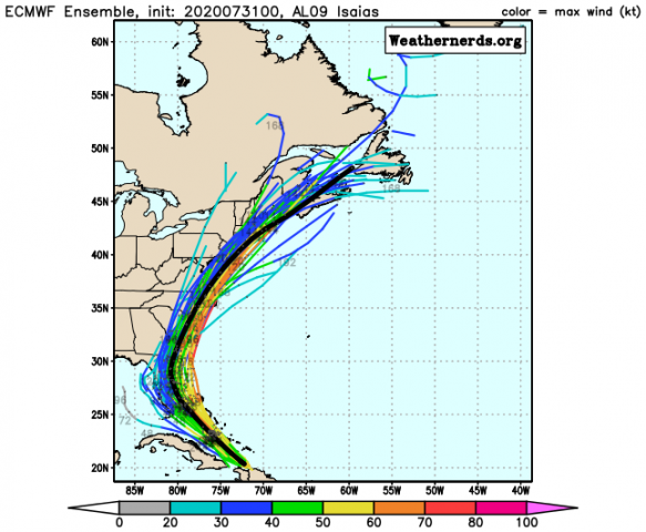
Frank_Wx wrote:EURO Ensembles - oh boy
Hi Frank-- long time no talk. Hope all is well. Just FYI the links are showing up as broken for me-- no images. May just be an issue on my end though.
Regardless, this one has my attention. The similarities it shares with Irene are hard to ignore.

DAYBLAZER- Posts : 228
Reputation : 20
Join date : 2017-03-12
Location : Hopatcong, NJ Sussex County
Re: Hurricane Season 2020-Active Season-
![]() by sroc4 Fri Jul 31, 2020 8:37 am
by sroc4 Fri Jul 31, 2020 8:37 am
_________________
"In weather and in life, there's no winning and losing; there's only winning and learning."
WINTER 2012/2013 TOTALS 43.65"WINTER 2017/2018 TOTALS 62.85" WINTER 2022/2023 TOTALS 4.9"
WINTER 2013/2014 TOTALS 64.85"WINTER 2018/2019 TOTALS 14.25" WINTER 2023/2024 TOTALS 13.1"
WINTER 2014/2015 TOTALS 71.20"WINTER 2019/2020 TOTALS 6.35"
WINTER 2015/2016 TOTALS 35.00"WINTER 2020/2021 TOTALS 37.75"
WINTER 2016/2017 TOTALS 42.25"WINTER 2021/2022 TOTALS 31.65"

sroc4- Admin
- Posts : 8331
Reputation : 301
Join date : 2013-01-07
Location : Wading River, LI
Re: Hurricane Season 2020-Active Season-
![]() by Grselig Fri Jul 31, 2020 8:46 am
by Grselig Fri Jul 31, 2020 8:46 am
Frank_Wx wrote:Looks like I need to pay closer attention to hurricane Isaias....
Just when you thought it was safe to ignore the weather, it pulled you back in.

Grselig- Senior Enthusiast
- Posts : 1408
Reputation : 140
Join date : 2013-03-04
Age : 54
Location : Wayne NJ
Re: Hurricane Season 2020-Active Season-
![]() by sroc4 Fri Jul 31, 2020 8:59 am
by sroc4 Fri Jul 31, 2020 8:59 am
jmanley32 wrote:Frank_Wx wrote:Looks like I need to pay closer attention to hurricane Isaias....
Yes you do I expect hourly updates...lol jk, what are your thoughts?
meanwhile oh boy hwrf....ray your following the hurricane models.
Just remember there are still pretty drastic differences in exact track and intensity inside 48hrs between models. Let alone in 4-5 days from now. There is a fair amount of shear to contend with on both GFS and Euro on the NW flank during this time frame, and I’m even seeing a dry air threat showing up on the euro and to a degree the GFS as well, between about 600-500mb on the SW flank That could play a role in limiting its intensification. Still a lot of details to iron out right out in front of us let along what’s happening out and around the bend.
_________________
"In weather and in life, there's no winning and losing; there's only winning and learning."
WINTER 2012/2013 TOTALS 43.65"WINTER 2017/2018 TOTALS 62.85" WINTER 2022/2023 TOTALS 4.9"
WINTER 2013/2014 TOTALS 64.85"WINTER 2018/2019 TOTALS 14.25" WINTER 2023/2024 TOTALS 13.1"
WINTER 2014/2015 TOTALS 71.20"WINTER 2019/2020 TOTALS 6.35"
WINTER 2015/2016 TOTALS 35.00"WINTER 2020/2021 TOTALS 37.75"
WINTER 2016/2017 TOTALS 42.25"WINTER 2021/2022 TOTALS 31.65"
sroc4- Admin
- Posts : 8331
Reputation : 301
Join date : 2013-01-07
Location : Wading River, LI
Re: Hurricane Season 2020-Active Season-
![]() by rb924119 Fri Jul 31, 2020 9:08 am
by rb924119 Fri Jul 31, 2020 9:08 am
jmanley32 wrote:Frank_Wx wrote:Looks like I need to pay closer attention to hurricane Isaias....
Yes you do I expect hourly updates...lol jk, what are your thoughts?
meanwhile oh boy hwrf....ray your following the hurricane models.
I liked THE MEAN of the Hurricane models, not just HWRF lol though I’d like to see them shift about 50 miles east from where they are, I really like the latest intensity forecast from them.
rb924119- Meteorologist
- Posts : 6888
Reputation : 194
Join date : 2013-02-06
Age : 32
Location : Greentown, Pa
Re: Hurricane Season 2020-Active Season-
![]() by jmanley32 Fri Jul 31, 2020 9:09 am
by jmanley32 Fri Jul 31, 2020 9:09 am
jmanley32- Senior Enthusiast
- Posts : 20512
Reputation : 108
Join date : 2013-12-12
Age : 42
Location : Yonkers, NY
Re: Hurricane Season 2020-Active Season-
![]() by jmanley32 Fri Jul 31, 2020 9:11 am
by jmanley32 Fri Jul 31, 2020 9:11 am
well it also depends on how much land he traverses before coming out on or around midatlantic NJ, that would change the intensity a lot. of course I know you look at them and take a blend.rb924119 wrote:jmanley32 wrote:Frank_Wx wrote:Looks like I need to pay closer attention to hurricane Isaias....
Yes you do I expect hourly updates...lol jk, what are your thoughts?
meanwhile oh boy hwrf....ray your following the hurricane models.
I liked THE MEAN of the Hurricane models, not just HWRF lol though I’d like to see them shift about 50 miles east from where they are, I really like the latest intensity forecast from them.
jmanley32- Senior Enthusiast
- Posts : 20512
Reputation : 108
Join date : 2013-12-12
Age : 42
Location : Yonkers, NY
Re: Hurricane Season 2020-Active Season-
![]() by rb924119 Fri Jul 31, 2020 9:12 am
by rb924119 Fri Jul 31, 2020 9:12 am
sroc4 wrote:jmanley32 wrote:Frank_Wx wrote:Looks like I need to pay closer attention to hurricane Isaias....
Yes you do I expect hourly updates...lol jk, what are your thoughts?
meanwhile oh boy hwrf....ray your following the hurricane models.
Just remember there are still pretty drastic differences in exact track and intensity inside 48hrs between models. Let alone in 4-5 days from now. There is a fair amount of shear to contend with on both GFS and Euro on the NW flank during this time frame, and I’m even seeing a dry air threat showing up on the euro and to a degree the GFS as well, between about 600-500mb on the SW flank That could play a role in limiting its intensification. Still a lot of details to iron out right out in front of us let along what’s happening out and around the bend.
Great points! Although I’m pretty sure I didn’t specifically mention this earlier, this is one reason (or I guess technically two reasons) why I don’t buy the stronger envelope of solutions.
rb924119- Meteorologist
- Posts : 6888
Reputation : 194
Join date : 2013-02-06
Age : 32
Location : Greentown, Pa
Re: Hurricane Season 2020-Active Season-
![]() by jmanley32 Fri Jul 31, 2020 9:16 am
by jmanley32 Fri Jul 31, 2020 9:16 am
Yeah no images eager to see them, scott do you have access? Yes I have been saying irene all this while.DAYBLAZER wrote:Frank_Wx wrote:EURO Ensembles - oh boy
Hi Frank-- long time no talk. Hope all is well. Just FYI the links are showing up as broken for me-- no images. May just be an issue on my end though.
Regardless, this one has my attention. The similarities it shares with Irene are hard to ignore.
jmanley32- Senior Enthusiast
- Posts : 20512
Reputation : 108
Join date : 2013-12-12
Age : 42
Location : Yonkers, NY
Re: Hurricane Season 2020-Active Season-
![]() by Sanchize06 Fri Jul 31, 2020 9:17 am
by Sanchize06 Fri Jul 31, 2020 9:17 am

Sanchize06- Senior Enthusiast
- Posts : 1041
Reputation : 21
Join date : 2013-02-05
Location : Union Beach, NJ
Re: Hurricane Season 2020-Active Season-
![]() by rb924119 Fri Jul 31, 2020 9:18 am
by rb924119 Fri Jul 31, 2020 9:18 am
jmanley32 wrote:well it also depends on how much land he traverses before coming out on or around midatlantic NJ, that would change the intensity a lot. of course I know you look at them and take a blend.rb924119 wrote:jmanley32 wrote:Frank_Wx wrote:Looks like I need to pay closer attention to hurricane Isaias....
Yes you do I expect hourly updates...lol jk, what are your thoughts?
meanwhile oh boy hwrf....ray your following the hurricane models.
I liked THE MEAN of the Hurricane models, not just HWRF lol though I’d like to see them shift about 50 miles east from where they are, I really like the latest intensity forecast from them.
Partially true, but the weaker the system, the less of a factor this becomes *if other factors are still supportive of maintenance/intensification*. For example, all things equal, it usually takes a lot longer for a tropical storm to weaken into a remnant low than it does for a Cat-5 to drop to a tropical storm once over land. Why? Because the stronger the storm, the more perfect conditions need to be in order for it to maintain intensity/strengthen, and any land interaction is less than optimal for a strong storm with an established core.
rb924119- Meteorologist
- Posts : 6888
Reputation : 194
Join date : 2013-02-06
Age : 32
Location : Greentown, Pa
Re: Hurricane Season 2020-Active Season-
![]() by rb924119 Fri Jul 31, 2020 9:21 am
by rb924119 Fri Jul 31, 2020 9:21 am
jmanley32 wrote:Oh I know scott was just showing the one run, and umm they only found 50-maybe 60mph winds in isaias this morning, that was short lived hurricane. what happened? pressure 995mb.
rb924119- Meteorologist
- Posts : 6888
Reputation : 194
Join date : 2013-02-06
Age : 32
Location : Greentown, Pa
Re: Hurricane Season 2020-Active Season-
![]() by jmanley32 Fri Jul 31, 2020 9:27 am
by jmanley32 Fri Jul 31, 2020 9:27 am
 got a bunch of 60-70 knot in there too as they approach area, cat 1 possible, but I say more likely TS IF it gets close.
jmanley32- Senior Enthusiast
- Posts : 20512
Reputation : 108
Join date : 2013-12-12
Age : 42
Location : Yonkers, NY
Re: Hurricane Season 2020-Active Season-
![]() by jmanley32 Fri Jul 31, 2020 10:57 am
by jmanley32 Fri Jul 31, 2020 10:57 am
jmanley32- Senior Enthusiast
- Posts : 20512
Reputation : 108
Join date : 2013-12-12
Age : 42
Location : Yonkers, NY
Re: Hurricane Season 2020-Active Season-
![]() by weatherwatchermom Fri Jul 31, 2020 12:00 pm
by weatherwatchermom Fri Jul 31, 2020 12:00 pm
Frank_Wx wrote:Looks like I need to pay closer attention to hurricane Isaias....
so are you going to be our hurricane hunter??

weatherwatchermom- Senior Enthusiast
- Posts : 3729
Reputation : 77
Join date : 2014-11-25
Age : 60
Location : Hazlet Township, NJ
Re: Hurricane Season 2020-Active Season-
![]() by jmanley32 Fri Jul 31, 2020 12:07 pm
by jmanley32 Fri Jul 31, 2020 12:07 pm

jmanley32- Senior Enthusiast
- Posts : 20512
Reputation : 108
Join date : 2013-12-12
Age : 42
Location : Yonkers, NY
Re: Hurricane Season 2020-Active Season-
![]() by jmanley32 Fri Jul 31, 2020 1:40 pm
by jmanley32 Fri Jul 31, 2020 1:40 pm


Last edited by jmanley32 on Fri Jul 31, 2020 1:59 pm; edited 1 time in total
jmanley32- Senior Enthusiast
- Posts : 20512
Reputation : 108
Join date : 2013-12-12
Age : 42
Location : Yonkers, NY
Re: Hurricane Season 2020-Active Season-
![]() by jmanley32 Fri Jul 31, 2020 1:55 pm
by jmanley32 Fri Jul 31, 2020 1:55 pm
Location: 22.2°N 75.2°W
Moving: NW at 16 mph
Min pressure: 991 mb
Max sustained: 75 mph
jmanley32- Senior Enthusiast
- Posts : 20512
Reputation : 108
Join date : 2013-12-12
Age : 42
Location : Yonkers, NY
Re: Hurricane Season 2020-Active Season-
![]() by jmanley32 Fri Jul 31, 2020 2:31 pm
by jmanley32 Fri Jul 31, 2020 2:31 pm


jmanley32- Senior Enthusiast
- Posts : 20512
Reputation : 108
Join date : 2013-12-12
Age : 42
Location : Yonkers, NY
jmanley32- Senior Enthusiast
- Posts : 20512
Reputation : 108
Join date : 2013-12-12
Age : 42
Location : Yonkers, NY
Re: Hurricane Season 2020-Active Season-
![]() by gigs68 Fri Jul 31, 2020 4:11 pm
by gigs68 Fri Jul 31, 2020 4:11 pm
jmanley32 wrote:where is everyone lol
Probably outside in their yard pruning those vulnerable trees

gigs68- Posts : 142
Reputation : 3
Join date : 2013-01-16
Location : Commack, NY (NW Suffolk)
Page 12 of 25 • 1 ... 7 ... 11, 12, 13 ... 18 ... 25 ![]()
|
|
|