
 Search
Long Range Discussion 20(20) (Ha!)
Page 16 of 30 •  1 ... 9 ... 15, 16, 17 ... 23 ... 30
 ![]()
Re: Long Range Discussion 20(20) (Ha!)
![]() by amugs Wed Dec 30, 2020 8:54 pm
by amugs Wed Dec 30, 2020 8:54 pm
Yes that looks like cold to Arctic. Over 90% of Arctic heat is coming from Norwegian current.
— peikko763
If heat transport from Atlantic decreases so much it will mean cold Arctic at future. Of course heat transfer/freezing up have years to time lags. I say ~10 yearshttps://t.co/rv8buhbYE7 pic.twitter.com/IcBvaG5pdu
(@peikko763) December 27, 2020
AMOC - Atlantic Ocean Multidecadal Oscillation
Yes that looks like cold to Arctic. Over 90% of Arctic heat is coming from Norwegian current.
— peikko763
If heat transport from Atlantic decreases so much it will mean cold Arctic at future. Of course heat transfer/freezing up have years to time lags. I say ~10 years
amugs- Advanced Forecaster - Mod

- Posts : 15091
Join date : 2013-01-07

hyde345- Pro Enthusiast

- Posts : 1082
Join date : 2013-01-08
Re: Long Range Discussion 20(20) (Ha!)
![]() by rb924119 Thu Dec 31, 2020 12:11 am
by rb924119 Thu Dec 31, 2020 12:11 am
rb924119- Meteorologist

- Posts : 6888
Reputation : 194
Join date : 2013-02-06
Age : 32
Location : Greentown, Pa
Re: Long Range Discussion 20(20) (Ha!)
![]() by Snow88 Thu Dec 31, 2020 12:42 am
by Snow88 Thu Dec 31, 2020 12:42 am
Storms after storms
Get ready because this pattern looks explosive

Snow88- Senior Enthusiast

- Posts : 2193
Reputation : 4
Join date : 2013-01-09
Age : 35
Location : Brooklyn, NY
Re: Long Range Discussion 20(20) (Ha!)
![]() by Snow88 Thu Dec 31, 2020 12:44 am
by Snow88 Thu Dec 31, 2020 12:44 am
rb924119 wrote:I’m sorry, but there is literally almost nothing that excites me right now for the next few weeks other than predominantly cold rains unless you’re either on the far northern/western fringes of our forecast area, and even there, it’s not that exciting. Sure we have Atlantic blocking, which has been incredibly elusive in recent years, but when you’re blocking nothing but stale Pacific air without any Arctic tap it does us no good as the heights will likely just keep trying to connect from the western Atlantic and draw too much warmth northward even with favorable storm tracks. Our only hope, in my opinion, is that the NAO blocking can eventually retrograde westward far enough to start substantially altering the northern latitudes of the Pacific domain and allowing truly Arctic highs to get involved, or else I think our goose is cooked again this year. I don’t like what I’m seeing with the Stratosphere, and the tropics are certainly not playing nicely.
Really ? There are alot of things to be excited about. Models have a better pna ridge out west along with the NAO going west based. Epo also trends favorable.
All we need is the cold air. We already have the storms.
The stratosphere right now is taking a huge beating
Snow88- Senior Enthusiast
- Posts : 2193
Reputation : 4
Join date : 2013-01-09
Age : 35
Location : Brooklyn, NY
Definition of few weeks
![]() by chief7 Thu Dec 31, 2020 1:18 am
by chief7 Thu Dec 31, 2020 1:18 am
rb924119 wrote:I’m sorry, but there is literally almost nothing that excites me right now for the next few weeks other than predominantly cold rains unless you’re either on the far northern/western fringes of our forecast area, and even there, it’s not that exciting. Sure we have Atlantic blocking, which has been incredibly elusive in recent years, but when you’re blocking nothing but stale Pacific air without any Arctic tap it does us no good as the heights will likely just keep trying to connect from the western Atlantic and draw too much warmth northward even with favorable storm tracks. Our only hope, in my opinion, is that the NAO blocking can eventually retrograde westward far enough to start substantially altering the northern latitudes of the Pacific domain and allowing truly Arctic highs to get involved, or else I think our goose is cooked again this year. I don’t like what I’m seeing with the Stratosphere, and the tropics are certainly not playing nicely.
chief7- Posts : 132
Reputation : 0
Join date : 2013-11-10
Location : Langhorne pa
chief7- Posts : 132
Reputation : 0
Join date : 2013-11-10
Location : Langhorne pa
Re: Long Range Discussion 20(20) (Ha!)
![]() by heehaw453 Thu Dec 31, 2020 8:20 am
by heehaw453 Thu Dec 31, 2020 8:20 am

heehaw453- Advanced Forecaster

- Posts : 3904
Reputation : 86
Join date : 2014-01-20
Location : Bedminster Township, PA Elevation 600' ASL
Re: Long Range Discussion 20(20) (Ha!)
![]() by heehaw453 Thu Dec 31, 2020 8:27 am
by heehaw453 Thu Dec 31, 2020 8:27 am
rb924119 wrote:I’m sorry, but there is literally almost nothing that excites me right now for the next few weeks other than predominantly cold rains unless you’re either on the far northern/western fringes of our forecast area, and even there, it’s not that exciting. Sure we have Atlantic blocking, which has been incredibly elusive in recent years, but when you’re blocking nothing but stale Pacific air without any Arctic tap it does us no good as the heights will likely just keep trying to connect from the western Atlantic and draw too much warmth northward even with favorable storm tracks. Our only hope, in my opinion, is that the NAO blocking can eventually retrograde westward far enough to start substantially altering the northern latitudes of the Pacific domain and allowing truly Arctic highs to get involved, or else I think our goose is cooked again this year. I don’t like what I’m seeing with the Stratosphere, and the tropics are certainly not playing nicely.
I agree with you in that if we get absolutely no cooperation with the PAC in the EPO domain, then the block in Davis Straight just traps the PAC air. It can still snow of course and probably will, but the KU potential is lost. You'd be looking at light to at most moderate chances and few and far between. If however the cork opens up in the EPO then things will get interesting as the colder air can bleed into the Eastern US. I don't trust the models post 10 days ensembles included, so I'm cautiously optimistic. I also don't think anyone has a good handle of the effects of this SSWE at this time. It's better to be guarded right now.
heehaw453- Advanced Forecaster
- Posts : 3904
Reputation : 86
Join date : 2014-01-20
Location : Bedminster Township, PA Elevation 600' ASL
Re: Long Range Discussion 20(20) (Ha!)
![]() by heehaw453 Thu Dec 31, 2020 8:45 am
by heehaw453 Thu Dec 31, 2020 8:45 am

heehaw453- Advanced Forecaster
- Posts : 3904
Reputation : 86
Join date : 2014-01-20
Location : Bedminster Township, PA Elevation 600' ASL
Re: Long Range Discussion 20(20) (Ha!)
![]() by Frank_Wx Thu Dec 31, 2020 8:47 am
by Frank_Wx Thu Dec 31, 2020 8:47 am
Keep in mind just the day prior, January 2nd, majority of us will see rain and temps surpassing 50 degrees. The storm on the 3rd is working with a moderated and mild air mass, so somehow the cold air needs to get pulled into the core of the low pressure system as it forms off the coast. This certainly is no “bombogenesis” but natural cyclogenesis will take place.

It’s a very weak low along with weak HP to the north. Cold air is absent from the region, but it’s cold ENOUGH near I-84 and places just south of there for it to snow. Climo is helping those areas!
Let’s see how this trends the next couple of days. My guess is we’ll see a cold trend begin, because models are under doing the strength of the low pressure system at this juncture. However, I don’t think it gets cold enough for I-95. We will see little to no snow from this. I am talking about just N&W of I-95 (think Morris, Warren and Hunterdon counties) who may benefit from a cold trend.
6 or more inches of snow, or a Mothrazilla, is the opportunity for those near I-84.
_________________
_______________________________________________________________________________________________________
CLICK HERE to view NJ Strong Snowstorm Classifications

Frank_Wx- Godzilla Seeker

- Posts : 21305
Reputation : 328
Join date : 2013-01-05
Age : 31
Location : Jersey City, NJ -

Re: Long Range Discussion 20(20) (Ha!)
![]() by Frank_Wx Thu Dec 31, 2020 8:51 am
by Frank_Wx Thu Dec 31, 2020 8:51 am
_________________
_______________________________________________________________________________________________________
CLICK HERE to view NJ Strong Snowstorm Classifications
Frank_Wx- Godzilla Seeker
- Posts : 21305
Reputation : 328
Join date : 2013-01-05
Age : 31
Location : Jersey City, NJ -
Re: Long Range Discussion 20(20) (Ha!)
![]() by rb924119 Thu Dec 31, 2020 9:06 am
by rb924119 Thu Dec 31, 2020 9:06 am
Snow88 wrote:rb924119 wrote:I’m sorry, but there is literally almost nothing that excites me right now for the next few weeks other than predominantly cold rains unless you’re either on the far northern/western fringes of our forecast area, and even there, it’s not that exciting. Sure we have Atlantic blocking, which has been incredibly elusive in recent years, but when you’re blocking nothing but stale Pacific air without any Arctic tap it does us no good as the heights will likely just keep trying to connect from the western Atlantic and draw too much warmth northward even with favorable storm tracks. Our only hope, in my opinion, is that the NAO blocking can eventually retrograde westward far enough to start substantially altering the northern latitudes of the Pacific domain and allowing truly Arctic highs to get involved, or else I think our goose is cooked again this year. I don’t like what I’m seeing with the Stratosphere, and the tropics are certainly not playing nicely.
Really ? There are alot of things to be excited about. Models have a better pna ridge out west along with the NAO going west based. Epo also trends favorable.
All we need is the cold air. We already have the storms.
The stratosphere right now is taking a huge beating
Unless you can substantially retract the Pacific jet, any PNA ridge spike is going to be transient and generally lower amplitude because there is going to be a firehouse of energy blasting into the western North America. This is also why we continue to flood North America with Pacific air. Additionally, because there is so much momentum in the mid-latitude belt of the Pacific domain, I’m quite fearful that the retrogression of the NAO domain blocking is stopped short of making it into the PNA/EPO domains and ends up falling apart. This is already being hinted at by the modeling, in my opinion, and if it plays out that way, that will hurt. Regarding the Strat, yes, it’s taking a hit, but that doesn’t guarantee us anything. The vortex could end up over Eurasia and leave us with more of the same, and unfortunately, that’s what looks more likely than not to me based on what I’m seeing.
rb924119- Meteorologist
- Posts : 6888
Reputation : 194
Join date : 2013-02-06
Age : 32
Location : Greentown, Pa
Re: Long Range Discussion 20(20) (Ha!)
![]() by rb924119 Thu Dec 31, 2020 9:08 am
by rb924119 Thu Dec 31, 2020 9:08 am
chief7 wrote:Definition of a few weeks
Extending from Week 2 into Week 3 (beyond the temporal range of most guidance)
rb924119- Meteorologist
- Posts : 6888
Reputation : 194
Join date : 2013-02-06
Age : 32
Location : Greentown, Pa
Re: Long Range Discussion 20(20) (Ha!)
![]() by rb924119 Thu Dec 31, 2020 9:12 am
by rb924119 Thu Dec 31, 2020 9:12 am
heehaw453 wrote:rb924119 wrote:I’m sorry, but there is literally almost nothing that excites me right now for the next few weeks other than predominantly cold rains unless you’re either on the far northern/western fringes of our forecast area, and even there, it’s not that exciting. Sure we have Atlantic blocking, which has been incredibly elusive in recent years, but when you’re blocking nothing but stale Pacific air without any Arctic tap it does us no good as the heights will likely just keep trying to connect from the western Atlantic and draw too much warmth northward even with favorable storm tracks. Our only hope, in my opinion, is that the NAO blocking can eventually retrograde westward far enough to start substantially altering the northern latitudes of the Pacific domain and allowing truly Arctic highs to get involved, or else I think our goose is cooked again this year. I don’t like what I’m seeing with the Stratosphere, and the tropics are certainly not playing nicely.
I agree with you in that if we get absolutely no cooperation with the PAC in the EPO domain, then the block in Davis Straight just traps the PAC air. It can still snow of course and probably will, but the KU potential is lost. You'd be looking at light to at most moderate chances and few and far between. If however the cork opens up in the EPO then things will get interesting as the colder air can bleed into the Eastern US. I don't trust the models post 10 days ensembles included, so I'm cautiously optimistic. I also don't think anyone has a good handle of the effects of this SSWE at this time. It's better to be guarded right now.
Therein lies our differences, I think - I don’t think our retrograding NAO blocking is going to be able make it far enough west with enough amplitude to substantially alter the Pacific domains based on what I’m seeing. I think it ends up falling apart, and any western North American ridge that does spike will certainly be transient and capped at lower amplitude during the process of NAO domain ridging retrogression. However, if the opposite occurs, then yes, we are the same page
rb924119- Meteorologist
- Posts : 6888
Reputation : 194
Join date : 2013-02-06
Age : 32
Location : Greentown, Pa
Re: Long Range Discussion 20(20) (Ha!)
![]() by rb924119 Thu Dec 31, 2020 9:27 am
by rb924119 Thu Dec 31, 2020 9:27 am
Frank_Wx wrote:Those N&W of NYC should prepare for a possible significant snowfall on the 3rd. There’s agreement among models for a low to track off the coast and bring a stripe of moderate to heavy snow across NEPA, SNY, and NWNJ. Boston will also get in on some of the action. It will be interesting to see if this trends colder so that places closer to I-95 (mostly N&W of there) see snow.
Keep in mind just the day prior, January 2nd, majority of us will see rain and temps surpassing 50 degrees. The storm on the 3rd is working with a moderated and mild air mass, so somehow the cold air needs to get pulled into the core of the low pressure system as it forms off the coast. This certainly is no “bombogenesis” but natural cyclogenesis will take place.
It’s a very weak low along with weak HP to the north. Cold air is absent from the region, but it’s cold ENOUGH near I-84 and places just south of there for it to snow. Climo is helping those areas!
Let’s see how this trends the next couple of days. My guess is we’ll see a cold trend begin, because models are under doing the strength of the low pressure system at this juncture. However, I don’t think it gets cold enough for I-95. We will see little to no snow from this. I am talking about just N&W of I-95 (think Morris, Warren and Hunterdon counties) who may benefit from a cold trend.
6 or more inches of snow, or a Mothrazilla, is the opportunity for those near I-84.
Respectfully disagree, Frank, I think this ends up trending a bit warmer as we get closer, and anywhere south of an east-west line along the NY/PA border will be completely out of the game. With your primaries already cutting west without any established block in a modified airmass, the warmth should likely be able to surge further northward regardless of surface storm track. Heehaw has done a great job of highlighting this issue, and to be honest, I think the primaries will end up getting further north and west in time, similarly to Gail.
As for the extended, I again respectfully disagree *based on the difference of how I think the blocking will evolve*. As I said to Heehaw, I don’t think the blocking makes it far enough west to alter the Pacific domains. If that turns out to be incorrect, then yeah, buckle up lol
rb924119- Meteorologist
- Posts : 6888
Reputation : 194
Join date : 2013-02-06
Age : 32
Location : Greentown, Pa
Re: Long Range Discussion 20(20) (Ha!)
![]() by amugs Thu Dec 31, 2020 10:13 am
by amugs Thu Dec 31, 2020 10:13 am
A west base NAO does wonders to the higher than normal chances of snow in the heart of winter. We do not need 15 degree cold air to snow just cold enough which again the heart of winter Jan and to mid Feb is certainly attainable.
Negative West Based NAO along with a 3 SD sigma AO can allow for 50/50 lows, HP over NE Can to get locked in, slow storms down and press them off the coast from cutting to our West.
We have a strong PAC JET but that doesn't not mean we can not snow here. Heck 1993-94 we had a Solid NEG PNA and we did well that winter as the Baroclonic zone set up to our south by the DelMarva. KU chasing we need a PNA ridge yes with the AO and NAO tandem.
But we have a muted overall MJO in phase 2 then 3 which is cold to menza menza in 3.
SSW can send the PV to Siberia true if it splits and then other piece to AK or Kalamazoo MI then we have just very cd and dry weather.
I see that as opportunities we have not seen since 17-18 but possibly better.
Time will tell but many factors in my opinion are pointing us in the positive direction.
_________________
Mugs
AKA:King: Snow Weenie
Self Proclaimed
WINTER 2014-15 : 55.12" +.02 for 6 coatings (avg. 35")
WINTER 2015-16 Total - 29.8" (Avg 35")
WINTER 2016-17 : 39.5" so far

amugs- Advanced Forecaster - Mod
- Posts : 15091
Reputation : 213
Join date : 2013-01-07
Age : 54
Location : Hillsdale,NJ
brownie likes this post
Re: Long Range Discussion 20(20) (Ha!)
![]() by rb924119 Thu Dec 31, 2020 10:37 am
by rb924119 Thu Dec 31, 2020 10:37 am
amugs wrote:Rb,
A west base NAO does wonders to the higher than normal chances of snow in the heart of winter. We do not need 15 degree cold air to snow just cold enough which again the heart of winter Jan and to mid Feb is certainly attainable.
Negative West Based NAO along with a 3 SD sigma AO can allow for 50/50 lows, HP over NE Can to get locked in, slow storms down and press them off the coast from cutting to our West.
We have a strong PAC JET but that doesn't not mean we can not snow here. Heck 1993-94 we had a Solid NEG PNA and we did well that winter as the Baroclonic zone set up to our south by the DelMarva. KU chasing we need a PNA ridge yes with the AO and NAO tandem.
But we have a muted overall MJO in phase 2 then 3 which is cold to menza menza in 3.
SSW can send the PV to Siberia true if it splits and then other piece to AK or Kalamazoo MI then we have just very cd and dry weather.
I see that as opportunities we have not seen since 17-18 but possibly better.
Time will tell but many factors in my opinion are pointing us in the positive direction.
Yes, I agree with you that it can, but you can’t just look at one or two signals and automatically assume it will snow. It’s all connected. Sure, we can snow in a modified airmass during the climatological minimum, but when you routinely start with low-levels that are +3-6C and are relying purely on dynamics/any remaining stale cold air to cool that column without any connection to truly arctic air, and a pattern that doesn’t support that connection, finding snow will still be difficult, especially along the coast.
Regarding your 93-94 analog, we had pacific help, as the EPO/WPO averaged moderately negative, and the PNA was actually slightly positive from Dec-February, coupled with a negative AO. So that allowed truly arctic air masses to be driven into the CONUS and be reinforced. This year, all of our blocking is originating from DOWNSTREAM, which means Atlantic influence on top of Pacific influence. Best example I can think of to demonstrate this as a problem, look at your forecast surface pressure anomalies; they remain to our north and east with nothing but low pressure to our north and west. That’s not a recipe for true cold to press. It’s a recipe that allows for any modified cold to retreat. Until we get a press from the north and west, I do not think that our fortunes will change, and I really don’t see evidence of getting sustained higher pressure to our north and west right now.
rb924119- Meteorologist
- Posts : 6888
Reputation : 194
Join date : 2013-02-06
Age : 32
Location : Greentown, Pa
Re: Long Range Discussion 20(20) (Ha!)
![]() by rb924119 Thu Dec 31, 2020 10:44 am
by rb924119 Thu Dec 31, 2020 10:44 am
rb924119- Meteorologist
- Posts : 6888
Reputation : 194
Join date : 2013-02-06
Age : 32
Location : Greentown, Pa
Re: Long Range Discussion 20(20) (Ha!)
![]() by heehaw453 Thu Dec 31, 2020 11:10 am
by heehaw453 Thu Dec 31, 2020 11:10 am
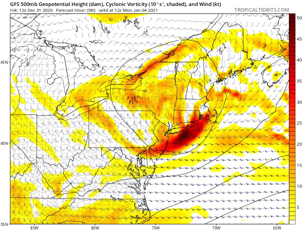
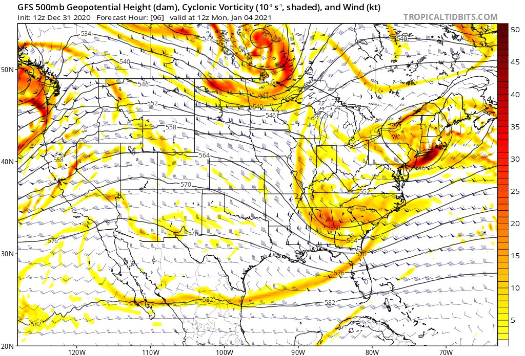
This is the ball game right here IMO. Where does this ULL get stopped. It's not set in stone yet IMO and as I said the block maybe underappreciated by the models right now.

heehaw453- Advanced Forecaster
- Posts : 3904
Reputation : 86
Join date : 2014-01-20
Location : Bedminster Township, PA Elevation 600' ASL
Re: Long Range Discussion 20(20) (Ha!)
![]() by sroc4 Thu Dec 31, 2020 11:58 am
by sroc4 Thu Dec 31, 2020 11:58 am
sroc4 wrote:Bottom line is the lack of cold air at the surface and just above is killing us. The freezing line ahead of the storm extends way up beyond the US Canadian boarder. Yes the dynamics are great but there is nowhere to draw cold air in from. Don’t hold your breath for this one.
Fun to track though. Cheers!
The only difference is the freezing line at the surface is not nearly as far away. In fact its only about 100-150miles away vs 300miles away in early Dec. And the freezing line in the mid levels isn't nearly as far away either. With that storm My neck of the woods was very close to a change over as the storm pulled away. We had the occasional mixing occur. So what's the point? Well one month later we have climatology on our side. For places like the coastal plain its still not a likely scenario for accumulating snow or even white rain, although still possible, but just off the coast needs to pay attention to the details and timing of said details. There still are diff between global models at 500 and 700. Like the system early Dec exact positioning and strength at 700mb will likely dictate if anyone off the coast snows and/or accumulates.
_________________
"In weather and in life, there's no winning and losing; there's only winning and learning."
WINTER 2012/2013 TOTALS 43.65"WINTER 2017/2018 TOTALS 62.85" WINTER 2022/2023 TOTALS 4.9"
WINTER 2013/2014 TOTALS 64.85"WINTER 2018/2019 TOTALS 14.25" WINTER 2023/2024 TOTALS 13.1"
WINTER 2014/2015 TOTALS 71.20"WINTER 2019/2020 TOTALS 6.35"
WINTER 2015/2016 TOTALS 35.00"WINTER 2020/2021 TOTALS 37.75"
WINTER 2016/2017 TOTALS 42.25"WINTER 2021/2022 TOTALS 31.65"

sroc4- Admin
- Posts : 8331
Reputation : 301
Join date : 2013-01-07
Location : Wading River, LI
heehaw453 likes this post
Re: Long Range Discussion 20(20) (Ha!)
![]() by CPcantmeasuresnow Thu Dec 31, 2020 12:14 pm
by CPcantmeasuresnow Thu Dec 31, 2020 12:14 pm


CPcantmeasuresnow- Wx Statistician Guru

- Posts : 7274
Reputation : 230
Join date : 2013-01-07
Age : 103
Location : Eastern Orange County, NY
Re: Long Range Discussion 20(20) (Ha!)
![]() by amugs Thu Dec 31, 2020 12:52 pm
by amugs Thu Dec 31, 2020 12:52 pm
Coming around to EURO and UKMET idea for a further southern snow line of I -80 North. Well see.
_________________
Mugs
AKA:King: Snow Weenie
Self Proclaimed
WINTER 2014-15 : 55.12" +.02 for 6 coatings (avg. 35")
WINTER 2015-16 Total - 29.8" (Avg 35")
WINTER 2016-17 : 39.5" so far
amugs- Advanced Forecaster - Mod
- Posts : 15091
Reputation : 213
Join date : 2013-01-07
Age : 54
Location : Hillsdale,NJ
Re: Long Range Discussion 20(20) (Ha!)
![]() by CPcantmeasuresnow Thu Dec 31, 2020 1:24 pm
by CPcantmeasuresnow Thu Dec 31, 2020 1:24 pm
12Z CMC prefers the Hyde, Jim area of MHV

CPcantmeasuresnow- Wx Statistician Guru
- Posts : 7274
Reputation : 230
Join date : 2013-01-07
Age : 103
Location : Eastern Orange County, NY
Re: Long Range Discussion 20(20) (Ha!)
![]() by heehaw453 Thu Dec 31, 2020 1:26 pm
by heehaw453 Thu Dec 31, 2020 1:26 pm
I think the models are starting to appreciate the block a bit more.
heehaw453- Advanced Forecaster
- Posts : 3904
Reputation : 86
Join date : 2014-01-20
Location : Bedminster Township, PA Elevation 600' ASL
Re: Long Range Discussion 20(20) (Ha!)
![]() by heehaw453 Thu Dec 31, 2020 1:37 pm
by heehaw453 Thu Dec 31, 2020 1:37 pm

heehaw453- Advanced Forecaster
- Posts : 3904
Reputation : 86
Join date : 2014-01-20
Location : Bedminster Township, PA Elevation 600' ASL
Re: Long Range Discussion 20(20) (Ha!)
![]() by heehaw453 Thu Dec 31, 2020 1:46 pm
by heehaw453 Thu Dec 31, 2020 1:46 pm
heehaw453- Advanced Forecaster
- Posts : 3904
Reputation : 86
Join date : 2014-01-20
Location : Bedminster Township, PA Elevation 600' ASL
Page 16 of 30 • 1 ... 9 ... 15, 16, 17 ... 23 ... 30 ![]()
|
|
|