
 Search
Long Range Discussion 22.0
Page 4 of 31 •  1, 2, 3, 4, 5 ... 17 ... 31
 ![]()
Re: Long Range Discussion 22.0
![]() by amugs Thu Nov 04, 2021 10:10 am
by amugs Thu Nov 04, 2021 10:10 am

amugs- Advanced Forecaster - Mod

- Posts : 15091
Join date : 2013-01-07
Re: Long Range Discussion 22.0
![]() by amugs Thu Nov 04, 2021 10:05 pm
by amugs Thu Nov 04, 2021 10:05 pm
Updated run of the ECMWF weeklies are complete.
— Ethan Sacoransky (@blizzardof96) November 4, 2021
They strongly indicate that weeks 3 & 4 of November will kickoff winter across the Eastern US and Canada. Classic signal for significant cold and snow potential. pic.twitter.com/wlrvhuPNOs
What's the significance of this event? The east-asian cutoff low allows the north pacific jet to amplify in a wavelike/stepwise pattern. Notice how this eventually results in a great lakes trough ~Nov 13th. pic.twitter.com/dkr7YeAuFT
— Ethan Sacoransky (@blizzardof96) November 5, 2021
amugs- Advanced Forecaster - Mod
- Posts : 15091
Join date : 2013-01-07
Re: Long Range Discussion 22.0
![]() by sroc4 Sat Nov 06, 2021 7:45 am
by sroc4 Sat Nov 06, 2021 7:45 am
sroc4 wrote:This is always fun to do. Below is the long range ensemble forecasts for both GEFS and Euro ENS depicting the mean 500mb height anomalies, valid 00z November 17th(15days from now) Notice the most prominent feature on both maps is the dark blues south of the Aleutian Islands. IF true this would lead to ridging along the West coast of NA; in turn troughing would be favored in the east. This would def lead to BN air masses and early snow chances; esp for the interior....if true.
Now make sure we keep expectations in check as this is 15days out, and as I pointed out above, if the MJO forecasts come to fruition there will be resistance in the atmosphere. It will be interesting to see how it evolves. Ill try and post updated snap shots of the evolution as we go along.
GEFS
Euro ENS
UPDATE: See above for latest images. First images was the one I posted from 00z 11/02, and the second was 00z 11/06. As you can see both GEFS and Euro Ens cont to feature a trough south of the Aleutians. That is key. The euro ensembles are now showing a stronger signal for a +PNA and -EPO. Both of which would mean a pretty significant cold shot into the NE ala a deep trough of Polar and perhaps even arctic origin. The GEFS on the other hand are not quite as robust on this, at least in this snap shot. On the GEFS image above the black arrow points out that little area of white in between the EPO and PNA regions indicating the possibility of pieces of energy breaking off the mean trough south of the Aleutians resulting in a decrease in the amplitude of the ridging along the west coast; particularly the PNA region. This could result in some Pac air mixing with our polar air mass, and the depth and amplitude of the trough into the NE would be diminished somewhat; the full extent unclear at this point.
The takeaway: It is becoming more and more clear that a significant trough looks likely south of the Aleutian islands; the result of which means troughing into the east. The 7-10day time frame seems to be the transition from a brief N to AN temp period(about a week) to a period of N to BN temps. Given the time of year and climatology I am def gaining confidence that at the very least our friends to the N&W of NYC, esp those with elevation, will get some good chances at seeing some measurable white gold after about the 13th-15th time frame. There are still some questions about the PNA and EPO regions and the duration of which these features are around, but confidence is gaining on a +PNA, -EPO couplet is on the horizon. As an FYI the AO and NAO appear to hover around neutral to slight negative as we head beyond the 7-10day timeframe. It does appear there is at least some staying power to the BN to N temp regime in the NE, but time will tell. Another update some time this week if possible.
_________________
"In weather and in life, there's no winning and losing; there's only winning and learning."
WINTER 2012/2013 TOTALS 43.65"WINTER 2017/2018 TOTALS 62.85" WINTER 2022/2023 TOTALS 4.9"
WINTER 2013/2014 TOTALS 64.85"WINTER 2018/2019 TOTALS 14.25" WINTER 2023/2024 TOTALS 13.1"
WINTER 2014/2015 TOTALS 71.20"WINTER 2019/2020 TOTALS 6.35"
WINTER 2015/2016 TOTALS 35.00"WINTER 2020/2021 TOTALS 37.75"
WINTER 2016/2017 TOTALS 42.25"WINTER 2021/2022 TOTALS 31.65"

sroc4- Admin

- Posts : 8331
Reputation : 301
Join date : 2013-01-07
Location : Wading River, LI
Re: Long Range Discussion 22.0
![]() by amugs Mon Nov 08, 2021 9:25 am
by amugs Mon Nov 08, 2021 9:25 am
Things are bigger in Asia! I crunched the numbers and #snow cover advanced 7 million sq km (from 13+ to 20+) across Central & East Asia the first week of November all south of 60ºN. That is comparable to the Contiguous US becoming snow covered in just one week's time. pic.twitter.com/J6A1gdTIJr
— Judah Cohen (@judah47) November 8, 2021
Good news I would assume.
_________________
Mugs
AKA:King: Snow Weenie
Self Proclaimed
WINTER 2014-15 : 55.12" +.02 for 6 coatings (avg. 35")
WINTER 2015-16 Total - 29.8" (Avg 35")
WINTER 2016-17 : 39.5" so far

amugs- Advanced Forecaster - Mod
- Posts : 15091
Reputation : 213
Join date : 2013-01-07
Age : 54
Location : Hillsdale,NJ
Re: Long Range Discussion 22.0
![]() by amugs Mon Nov 08, 2021 9:28 am
by amugs Mon Nov 08, 2021 9:28 am
_________________
Mugs
AKA:King: Snow Weenie
Self Proclaimed
WINTER 2014-15 : 55.12" +.02 for 6 coatings (avg. 35")
WINTER 2015-16 Total - 29.8" (Avg 35")
WINTER 2016-17 : 39.5" so far
amugs- Advanced Forecaster - Mod
- Posts : 15091
Reputation : 213
Join date : 2013-01-07
Age : 54
Location : Hillsdale,NJ
Re: Long Range Discussion 22.0
![]() by amugs Mon Nov 08, 2021 9:59 am
by amugs Mon Nov 08, 2021 9:59 am
https://www.nymetroweather.com/2021/11/05/nycwinterforecast2021/
December Temps - BN

January Temps - N to SAN

February - AN - SE ridge flexes its muscle

NYC Winter Forecast 2021-2022 Highlights
Temperatures: Slightly warmer than normal (0 to +2)
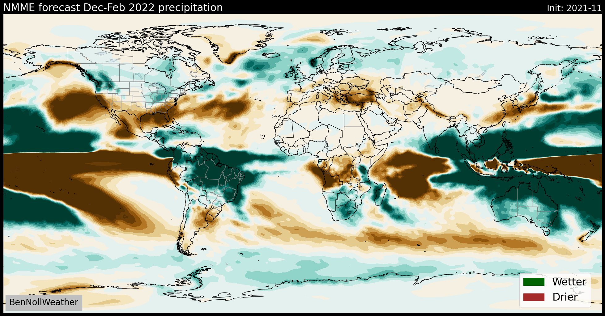
Precipitation: Wetter than normal
Snowfall: Slightly above normal (27-33″)
Winter 2021-2022 is expected to be off to a fast start, with colder than normal and more wintry than normal conditions in the NYC Metro during December. After a transitional month in January, warmer and less wintry than normal conditions are anticipated in February. While temperatures will average slightly above normal, we do anticipate snowfall to average slightly above normal as well.
_________________
Mugs
AKA:King: Snow Weenie
Self Proclaimed
WINTER 2014-15 : 55.12" +.02 for 6 coatings (avg. 35")
WINTER 2015-16 Total - 29.8" (Avg 35")
WINTER 2016-17 : 39.5" so far
amugs- Advanced Forecaster - Mod
- Posts : 15091
Reputation : 213
Join date : 2013-01-07
Age : 54
Location : Hillsdale,NJ
Re: Long Range Discussion 22.0
![]() by amugs Mon Nov 08, 2021 10:10 am
by amugs Mon Nov 08, 2021 10:10 am
why get https://t.co/kvqB5rsu2Z premium? Example post on the GEFS forecasted Dec Stratwarm and strongest analogs. Would be a disaster for the US if that analog package held. I go back thru 1948, line up patterns that are closest, then try to match them up. Labor of love pic.twitter.com/DVjEH1YH8l
— Joe Bastardi (@BigJoeBastardi) November 8, 2021
_________________
Mugs
AKA:King: Snow Weenie
Self Proclaimed
WINTER 2014-15 : 55.12" +.02 for 6 coatings (avg. 35")
WINTER 2015-16 Total - 29.8" (Avg 35")
WINTER 2016-17 : 39.5" so far
amugs- Advanced Forecaster - Mod
- Posts : 15091
Reputation : 213
Join date : 2013-01-07
Age : 54
Location : Hillsdale,NJ
Re: Long Range Discussion 22.0
![]() by Frank_Wx Tue Nov 09, 2021 8:10 am
by Frank_Wx Tue Nov 09, 2021 8:10 am
However, it seems the cold air will not stick around very long. The trough will get booted out by a weaker ridge middle of next week. We're not at a point where the pattern can lock itself in. Too many variables left to be figured out - PV, MJO, etc.
That said, looks like the Strat PV has undergone major strengthening and will go back to a weaker state beginning this weekend. That could potentially lead to another round of arctic air later this month.
_________________
_______________________________________________________________________________________________________
CLICK HERE to view NJ Strong Snowstorm Classifications

Frank_Wx- Godzilla Seeker
- Posts : 21305
Reputation : 328
Join date : 2013-01-05
Age : 31
Location : Jersey City, NJ -

Re: Long Range Discussion 22.0
![]() by amugs Tue Nov 09, 2021 8:42 am
by amugs Tue Nov 09, 2021 8:42 am
If the updated ECMWF monthlies are correct, we are looking at a cold December from the Canadian Prairies to the Great Lakes region.
— Ethan Sacoransky (@blizzardof96) November 8, 2021
The model has a strong signal for North Pacific ridging which introduces cross polar flow into the pattern. Resemblance to December 2008. pic.twitter.com/FdhvF9xrpb
_________________
Mugs
AKA:King: Snow Weenie
Self Proclaimed
WINTER 2014-15 : 55.12" +.02 for 6 coatings (avg. 35")
WINTER 2015-16 Total - 29.8" (Avg 35")
WINTER 2016-17 : 39.5" so far
amugs- Advanced Forecaster - Mod
- Posts : 15091
Reputation : 213
Join date : 2013-01-07
Age : 54
Location : Hillsdale,NJ
Re: Long Range Discussion 22.0
![]() by amugs Tue Nov 09, 2021 8:44 am
by amugs Tue Nov 09, 2021 8:44 am
More Snow?
— Justin Berk (@JustinWeather) November 9, 2021
A New Solar Cycle began last year and data supports this is the time we can expect more snow.
Here is a good case to have Faith in the Flakes based on the last 50 years when this has happened. #FITF and a -NAOhttps://t.co/AwmVzegPg5 pic.twitter.com/Qd0jWr2tY1
_________________
Mugs
AKA:King: Snow Weenie
Self Proclaimed
WINTER 2014-15 : 55.12" +.02 for 6 coatings (avg. 35")
WINTER 2015-16 Total - 29.8" (Avg 35")
WINTER 2016-17 : 39.5" so far
amugs- Advanced Forecaster - Mod
- Posts : 15091
Reputation : 213
Join date : 2013-01-07
Age : 54
Location : Hillsdale,NJ
Re: Long Range Discussion 22.0
![]() by amugs Tue Nov 09, 2021 8:45 am
by amugs Tue Nov 09, 2021 8:45 am


From 33 n Rain
_________________
Mugs
AKA:King: Snow Weenie
Self Proclaimed
WINTER 2014-15 : 55.12" +.02 for 6 coatings (avg. 35")
WINTER 2015-16 Total - 29.8" (Avg 35")
WINTER 2016-17 : 39.5" so far
amugs- Advanced Forecaster - Mod
- Posts : 15091
Reputation : 213
Join date : 2013-01-07
Age : 54
Location : Hillsdale,NJ
Re: Long Range Discussion 22.0
![]() by sroc4 Tue Nov 09, 2021 9:01 am
by sroc4 Tue Nov 09, 2021 9:01 am
amugs wrote:Weakening
From 33 n Rain
They are calling that weakening over at 33&rain Mugs? That looks like strengthening for the next week; then relatively maintained thereafter.
_________________
"In weather and in life, there's no winning and losing; there's only winning and learning."
WINTER 2012/2013 TOTALS 43.65"WINTER 2017/2018 TOTALS 62.85" WINTER 2022/2023 TOTALS 4.9"
WINTER 2013/2014 TOTALS 64.85"WINTER 2018/2019 TOTALS 14.25" WINTER 2023/2024 TOTALS 13.1"
WINTER 2014/2015 TOTALS 71.20"WINTER 2019/2020 TOTALS 6.35"
WINTER 2015/2016 TOTALS 35.00"WINTER 2020/2021 TOTALS 37.75"
WINTER 2016/2017 TOTALS 42.25"WINTER 2021/2022 TOTALS 31.65"
sroc4- Admin
- Posts : 8331
Reputation : 301
Join date : 2013-01-07
Location : Wading River, LI
Re: Long Range Discussion 22.0
![]() by sroc4 Tue Nov 09, 2021 9:03 am
by sroc4 Tue Nov 09, 2021 9:03 am
_________________
"In weather and in life, there's no winning and losing; there's only winning and learning."
WINTER 2012/2013 TOTALS 43.65"WINTER 2017/2018 TOTALS 62.85" WINTER 2022/2023 TOTALS 4.9"
WINTER 2013/2014 TOTALS 64.85"WINTER 2018/2019 TOTALS 14.25" WINTER 2023/2024 TOTALS 13.1"
WINTER 2014/2015 TOTALS 71.20"WINTER 2019/2020 TOTALS 6.35"
WINTER 2015/2016 TOTALS 35.00"WINTER 2020/2021 TOTALS 37.75"
WINTER 2016/2017 TOTALS 42.25"WINTER 2021/2022 TOTALS 31.65"
sroc4- Admin
- Posts : 8331
Reputation : 301
Join date : 2013-01-07
Location : Wading River, LI
Re: Long Range Discussion 22.0
![]() by amugs Tue Nov 09, 2021 9:39 am
by amugs Tue Nov 09, 2021 9:39 am
sroc4 wrote:amugs wrote:Weakening
From 33 n Rain
They are calling that weakening over at 33&rain Mugs? That looks like strengthening for the next week; then relatively maintained thereafter.
After that timeframe we see a weakening my man.
_________________
Mugs
AKA:King: Snow Weenie
Self Proclaimed
WINTER 2014-15 : 55.12" +.02 for 6 coatings (avg. 35")
WINTER 2015-16 Total - 29.8" (Avg 35")
WINTER 2016-17 : 39.5" so far
amugs- Advanced Forecaster - Mod
- Posts : 15091
Reputation : 213
Join date : 2013-01-07
Age : 54
Location : Hillsdale,NJ
Re: Long Range Discussion 22.0
![]() by Frank_Wx Tue Nov 09, 2021 11:35 am
by Frank_Wx Tue Nov 09, 2021 11:35 am
So, probably looking at a weak-moderate Nina this winter. Not too bad.
_________________
_______________________________________________________________________________________________________
CLICK HERE to view NJ Strong Snowstorm Classifications
Frank_Wx- Godzilla Seeker
- Posts : 21305
Reputation : 328
Join date : 2013-01-05
Age : 31
Location : Jersey City, NJ -
Re: Long Range Discussion 22.0
![]() by Frank_Wx Tue Nov 09, 2021 11:38 am
by Frank_Wx Tue Nov 09, 2021 11:38 am
https://1316da03-e6e5-4264-d4a8-7d2a1b50b5ed.filesusr.com/ugd/31d9e0_519744b0d9756384fa8e449e31fdd209.pdf
_________________
_______________________________________________________________________________________________________
CLICK HERE to view NJ Strong Snowstorm Classifications
Frank_Wx- Godzilla Seeker
- Posts : 21305
Reputation : 328
Join date : 2013-01-05
Age : 31
Location : Jersey City, NJ -
Re: Long Range Discussion 22.0
![]() by sroc4 Tue Nov 09, 2021 12:34 pm
by sroc4 Tue Nov 09, 2021 12:34 pm
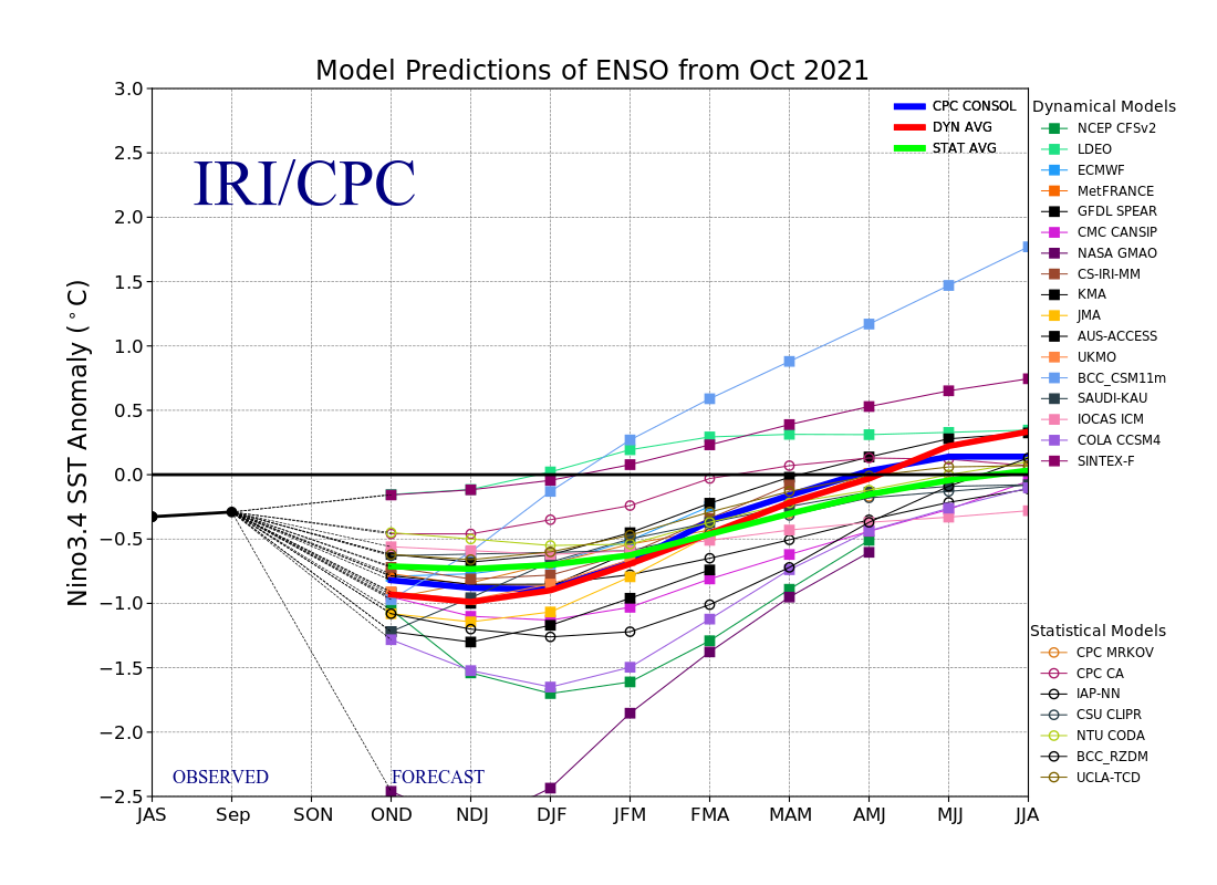
Frank_Wx wrote:Looks like region 3.4 in the ENSO is forecasted to warm a bit, which is good considering we did not want La Nina to overly dominate our pattern. This nicely corresponds to what the avg of stat models are predicting.
So, probably looking at a weak-moderate Nina this winter. Not too bad.
Frank don’t be so sure about that. A mod-strong is still on the table. That map you posted looks like it was from Sept.

_________________
"In weather and in life, there's no winning and losing; there's only winning and learning."
WINTER 2012/2013 TOTALS 43.65"WINTER 2017/2018 TOTALS 62.85" WINTER 2022/2023 TOTALS 4.9"
WINTER 2013/2014 TOTALS 64.85"WINTER 2018/2019 TOTALS 14.25" WINTER 2023/2024 TOTALS 13.1"
WINTER 2014/2015 TOTALS 71.20"WINTER 2019/2020 TOTALS 6.35"
WINTER 2015/2016 TOTALS 35.00"WINTER 2020/2021 TOTALS 37.75"
WINTER 2016/2017 TOTALS 42.25"WINTER 2021/2022 TOTALS 31.65"
sroc4- Admin
- Posts : 8331
Reputation : 301
Join date : 2013-01-07
Location : Wading River, LI
Re: Long Range Discussion 22.0
![]() by algae888 Tue Nov 09, 2021 12:46 pm
by algae888 Tue Nov 09, 2021 12:46 pm
Sub surface is Currently warming And looks like the peak of the LA Nina is late November or very early December. Also the WPO is going negative and to remain that way through late December This should allow very cold air to Work into Canadasroc4 wrote:Frank_Wx wrote:Looks like region 3.4 in the ENSO is forecasted to warm a bit, which is good considering we did not want La Nina to overly dominate our pattern. This nicely corresponds to what the avg of stat models are predicting.
So, probably looking at a weak-moderate Nina this winter. Not too bad.
Frank don’t be so sure about that. A mod-strong is still on the table. That map you posted looks like it was from Sept.

algae888- Advanced Forecaster

- Posts : 5311
Reputation : 46
Join date : 2013-02-05
Age : 61
Location : mt. vernon, new york
Re: Long Range Discussion 22.0
![]() by algae888 Tue Nov 09, 2021 12:52 pm
by algae888 Tue Nov 09, 2021 12:52 pm
algae888- Advanced Forecaster
- Posts : 5311
Reputation : 46
Join date : 2013-02-05
Age : 61
Location : mt. vernon, new york
Re: Long Range Discussion 22.0
![]() by algae888 Tue Nov 09, 2021 1:02 pm
by algae888 Tue Nov 09, 2021 1:02 pm
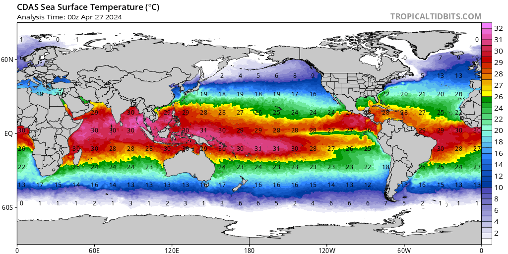
 Don't i don't know why the animations not working but the latest subsurface temperatures for November 4th show significant warming from this map above
algae888- Advanced Forecaster
- Posts : 5311
Reputation : 46
Join date : 2013-02-05
Age : 61
Location : mt. vernon, new york
Re: Long Range Discussion 22.0
![]() by amugs Tue Nov 09, 2021 5:04 pm
by amugs Tue Nov 09, 2021 5:04 pm

_________________
Mugs
AKA:King: Snow Weenie
Self Proclaimed
WINTER 2014-15 : 55.12" +.02 for 6 coatings (avg. 35")
WINTER 2015-16 Total - 29.8" (Avg 35")
WINTER 2016-17 : 39.5" so far
amugs- Advanced Forecaster - Mod
- Posts : 15091
Reputation : 213
Join date : 2013-01-07
Age : 54
Location : Hillsdale,NJ
weatherwatchermom likes this post
Re: Long Range Discussion 22.0
![]() by sroc4 Tue Nov 09, 2021 6:26 pm
by sroc4 Tue Nov 09, 2021 6:26 pm
algae888 wrote:Right now we have a coupled LA Nina with the atmosphere unlike last year which is good news considering LA nina's are often Fast starts to Winter. Also if we peak early enough it may prevent The usually warm 2nd half of winters during LA Nina's. Some good signs today a lot of mixed signals going forward and we will need the help in the North Atlantic this Winter
Al Im not sure why the SSTA animation map isn't working for you but I hope it works for me. I def see what your saying. Here is the Animation (hoping it works) for all to see. In addition is the last 4 month subsurface temp anomaly still frames on avg for the month. The black arrow in Oct and Nov is showing the area that has warmed more recently. This can be clearly seen happening over time on the animation.


But be careful with that. There is one particular met that I have seen a couple of times since this summer have to back track his thoughts because he underestimated the on coming La Nina. He currently is doing the same, calling for weak La Nina conditions, but it would not surprise me if he were to need to back track yet again because I think there will be another surge through the end of the year.
Al you are def correct in that the atmosphere is def in that Base state La nina, unlike last year around this same time. Take a look at the graph below. You can see that this year very abruptly the SOI shot up and went from a neutral state to a strong positive state between June and July and remained ever since; whereas, last year it was a much more modest and slow increase starting from a modest neg state early on before reaching moderate status later on. I think the rapid transition the beginning of the summer has allowed the La Nina more time to establish itself in the base state of the atmosphere. Meaning when other drivers are neutral the La Nina base state takes back over. driving the pattern. The stronger the base state of ENSO, the harder time other drivers will have influencing the pattern...in general.

In general when the SOI is in the positive state its considered La Nina conditions, and when its in the negative state its considered in the El Nino conditions, but more accurately stated when the 30 and 60 day avg is greater than or equal to +8 it is considered La Nina, and less than or equal to -8 its considered El Nino conditions; with values between -8 to +8 its considered La Nada or a neutral ENSO state.
Take a look at the next graph. Look at the time between Oct 20th - Nov 2nd. Notice the Daily contribution between these dates is mostly negative or neutral. The result is both the 30 day and 60 day avg dropped. But also notice the daily values have spiked again into the 20's and the 60 day avg has gone back up above the 8 threshold and the 30day avg is close.

So why is the SOI Important? The SOI value is calculated based on the relative mean surface pressure between Darwin Australia and Tahiti. When Darwin's pressure is lower relative to Tahiti then the SOI value increases. The closer Darwin's pressure comes to Tahiti's pressure the smaller the number becomes, and when Darwin's pressure becomes greater than Tahiti the number goes negative. Again why is that important?
Look at the images below. As we all know air tends to move from areas of HP to areas of LP. So you can picture in your mind that the mean flow of air wants to be westerly or to the west. This is the case when you have a base state in a La Nina.

Now use your imaginations and pretend that the trop Pacific is like a big bathtub filled with water only the temps of the water differ depending on which side of the bath tub (see the image below) or at what depth you are at(see the first two images/animation posted above). You can clearly see that the water to the north of Australia is very warm, and it slowly gets cooler as head east. Now image a giant fan located in the eastern Trop Pac is blowing along the surface. One would imagine that the longer and harder the fan blew to the west the more the relatively cooler waters in the eastern pac might get pushed or displace to the west into areas with relatively warmer waters mixing cooling them relative to normal. You could also just as easily image the opposite effect if the fan was in the west, N of Australia, pushing the relatively warmer waters easterly mixing with the relatively cooler waters in to the east making them warming relative to normal.
One also might imagine that if you were pushing the water on the surface to the west the water that gets displaced from immediately in front of the fan would need to be replaced. So imagine the water beneath the surface(upwelling) rises to replace the displaced water on the surface. So with this visualization it makes sense and one may expect to see colder than normal SSTA develop over time when the fan blows consistently from east to west as in La Nina years, and warmer sea surface temps if the fan blowing west to east during El Nino years. THIS is why and how you use the SOI index as an indicator of the base state of ENSO.
Now see the image below. This is the graph for ENSO region 3.4. You can see at the end of it we get a little rise in the SSTA. Refer back to the SOI index above. It no coincidence that with a flip in the SOI index going neutral to negative during this time frame that we got a surge in SSTA. Why? Image the fan again. Its been blowing fairly steadily at a mod speed for awhile from the east to the west. We have pushed a fair amount of water to the western side of the bath tub and the resistance from the fan has kept it there. What happens if you turn the fan down or off temporarily? You get a reflexively rebound of the water you pushed into the western side of the tub. A wave of warmer waters, relatively speaking, sloshes back, if you will, to the east because the resistance from the blowing fan is reduced. As you can see by the SOI daily contributions above from Nov 3rd through today the values have drastically gone back up strongly positive. The resulting 30day and 90day avg have both gone back up again. The short and md term forecast cont to show the MSLP in Tahit and Darwn to support the more positive SOI values. If we get a few more days of positive values you will see the trend on the graph below go back down pretty quickly.

Now to bring this all home, I really do still think we see predominately positive SOI values for the next 1.5-2 months. And even though there have been some warming in the sub-surfaces and its pushed a little east these areas are very deep and aren't ready to influence the ENSO status just yet. And I think the upwelling that occurs when the fan is blowing westerly, SOI is in a mod to strong positive state, will cont to cool the surface in the ENSO region to reach at least moderate La Nina status. Obv I dont know this for sure, but this is what my Spidey senses tell me. We shall see.
_________________
"In weather and in life, there's no winning and losing; there's only winning and learning."
WINTER 2012/2013 TOTALS 43.65"WINTER 2017/2018 TOTALS 62.85" WINTER 2022/2023 TOTALS 4.9"
WINTER 2013/2014 TOTALS 64.85"WINTER 2018/2019 TOTALS 14.25" WINTER 2023/2024 TOTALS 13.1"
WINTER 2014/2015 TOTALS 71.20"WINTER 2019/2020 TOTALS 6.35"
WINTER 2015/2016 TOTALS 35.00"WINTER 2020/2021 TOTALS 37.75"
WINTER 2016/2017 TOTALS 42.25"WINTER 2021/2022 TOTALS 31.65"
sroc4- Admin
- Posts : 8331
Reputation : 301
Join date : 2013-01-07
Location : Wading River, LI
Frank_Wx likes this post
Re: Long Range Discussion 22.0
![]() by sroc4 Thu Nov 11, 2021 12:34 pm
by sroc4 Thu Nov 11, 2021 12:34 pm
_________________
"In weather and in life, there's no winning and losing; there's only winning and learning."
WINTER 2012/2013 TOTALS 43.65"WINTER 2017/2018 TOTALS 62.85" WINTER 2022/2023 TOTALS 4.9"
WINTER 2013/2014 TOTALS 64.85"WINTER 2018/2019 TOTALS 14.25" WINTER 2023/2024 TOTALS 13.1"
WINTER 2014/2015 TOTALS 71.20"WINTER 2019/2020 TOTALS 6.35"
WINTER 2015/2016 TOTALS 35.00"WINTER 2020/2021 TOTALS 37.75"
WINTER 2016/2017 TOTALS 42.25"WINTER 2021/2022 TOTALS 31.65"
sroc4- Admin
- Posts : 8331
Reputation : 301
Join date : 2013-01-07
Location : Wading River, LI
Re: Long Range Discussion 22.0
![]() by algae888 Thu Nov 11, 2021 2:40 pm
by algae888 Thu Nov 11, 2021 2:40 pm
Today's GEFS and GEPS have corrected colder (western ridge) in line with last night's EPS. todays op euro has some very cold air across Canada by day 9. EPS usually follows suit. Models usually have hard time with pattern in the fall. More than likely fast start to Winter with classic coupled Nina. We shall seesroc4 wrote:What had looked like a fairly promising pattern to end Nov and start Dec is looking more like bleh.
algae888- Advanced Forecaster
- Posts : 5311
Reputation : 46
Join date : 2013-02-05
Age : 61
Location : mt. vernon, new york
Re: Long Range Discussion 22.0
![]() by algae888 Thu Nov 11, 2021 2:43 pm
by algae888 Thu Nov 11, 2021 2:43 pm
algae888- Advanced Forecaster
- Posts : 5311
Reputation : 46
Join date : 2013-02-05
Age : 61
Location : mt. vernon, new york
Re: Long Range Discussion 22.0
![]() by sroc4 Thu Nov 11, 2021 3:18 pm
by sroc4 Thu Nov 11, 2021 3:18 pm
algae888 wrote:I should also add GEFS has below normal 850's day 9 thru the end of the run
Al id take anything you see beyond day 7-10 with a huge grain of salt. Remember the evolution we were follwoing for Nov 17th? What happened to the trough S of the Alutian islands that seemed likely, and what happened to the possible +PNA/-EPO couplet....transient:
GEFS


Euro ENS


There are still some questions about the PNA and EPO regions and the duration of which these features are around, but confidence is gaining on a +PNA, -EPO couplet is on the horizon. As an FYI the AO and NAO appear to hover around neutral to slight negative as we head beyond the 7-10 day time frame. It does appear there is at least some staying power to the BN to N temp regime in the NE, but time will tell.
Well here is the current GEFS Ens(Euro is the same) for 00z Nov 17th. As you can see there is a deep negative now over the WC of Canada and the north west CONUS. The trough coming on the heals of tomorrows rain for next week has no staying power. It gets booted by that energy crashing the coast and the result if the SE ridge immediately flexing 24hrs later.


Here is the next snap shot to follow. So long as there is a negative showing up along the WC of Canada and NW CONUS the cold will be transient. 2-4 days then out. The question will be as the next cold shot swings through can we get a storm track that brings in the cold first vs the SE ridge means warm out ahead and the cold only on the heals of the frontal boundary. If we can lay down some snow pack into NE over the next few weeks hopefully the cold air masses become more dense and diff to scour out.

_________________
"In weather and in life, there's no winning and losing; there's only winning and learning."
WINTER 2012/2013 TOTALS 43.65"WINTER 2017/2018 TOTALS 62.85" WINTER 2022/2023 TOTALS 4.9"
WINTER 2013/2014 TOTALS 64.85"WINTER 2018/2019 TOTALS 14.25" WINTER 2023/2024 TOTALS 13.1"
WINTER 2014/2015 TOTALS 71.20"WINTER 2019/2020 TOTALS 6.35"
WINTER 2015/2016 TOTALS 35.00"WINTER 2020/2021 TOTALS 37.75"
WINTER 2016/2017 TOTALS 42.25"WINTER 2021/2022 TOTALS 31.65"
sroc4- Admin
- Posts : 8331
Reputation : 301
Join date : 2013-01-07
Location : Wading River, LI
Re: Long Range Discussion 22.0
![]() by sroc4 Thu Nov 11, 2021 4:03 pm
by sroc4 Thu Nov 11, 2021 4:03 pm
_________________
"In weather and in life, there's no winning and losing; there's only winning and learning."
WINTER 2012/2013 TOTALS 43.65"WINTER 2017/2018 TOTALS 62.85" WINTER 2022/2023 TOTALS 4.9"
WINTER 2013/2014 TOTALS 64.85"WINTER 2018/2019 TOTALS 14.25" WINTER 2023/2024 TOTALS 13.1"
WINTER 2014/2015 TOTALS 71.20"WINTER 2019/2020 TOTALS 6.35"
WINTER 2015/2016 TOTALS 35.00"WINTER 2020/2021 TOTALS 37.75"
WINTER 2016/2017 TOTALS 42.25"WINTER 2021/2022 TOTALS 31.65"
sroc4- Admin
- Posts : 8331
Reputation : 301
Join date : 2013-01-07
Location : Wading River, LI
Page 4 of 31 • 1, 2, 3, 4, 5 ... 17 ... 31 ![]()
|
|
|