Momentum building for possible storm on JAN 16th?
+45
uanswer2me
brownie
Vinnydula
1190ftalt
chief7
TheAresian
weatherwatchermom
Artingerb
Artechmetals
WeatherBob
billg315
Zhukov1945
Math23x7
RJB8525
Dunnzoo
SENJsnowman
Radz
Lnda23
algae888
aiannone
MattyICE
SoulSingMG
frank 638
Snow88
mmanisca
hurrysundown23
docstox12
jmanley32
amugs
Irish
Grselig
mikeypizano
essexcountypete
phil155
crippo84
hyde345
sroc4
lglickman1
dsix85
bobjohnsonforthehall
CPcantmeasuresnow
heehaw453
nutleyblizzard
rb924119
Frank_Wx
49 posters
Page 15 of 23
Page 15 of 23 •  1 ... 9 ... 14, 15, 16 ... 19 ... 23
 Re: Momentum building for possible storm on JAN 16th?
sroc4 wrote:heehaw453 wrote:A point that I have brought up before is I don't really have a good precedent of an ULL going south of Atlanta and then becoming an inland runner. It's really kind of extreme to do that. Even the 93 superstorm I don't believe ran that far inland more of extreme coastal hugger. Then again a lot of storms don't have TPV sling shot action like this one.
The main 500mb closes and matures so early that the mid level lows get pulled underneath and you begin getting the occluded situation. Obv when the upper and mid level centers start to align you end up pulling the SLP west along with it. Bottom line any time ewe get phasing energy in the middle of the country unless there is a mechanism (which we dont) to keep it suppressed it raises heights too quickly and we get warm sectored.
Yes...and early in the week we saw two main features trend worse:
1) -NAO block trended weaker and more east-based
2) Because of that, the Atlantic storm that was supposed to be our 50-50 low is no more. Instead we have an HP east of Maine
Pretty maddening that a southern slider turned into an apps runner that is probably going to transfer to a low off the coast. But by that point, there's no juice left and we all get dry slotted.
phil155 likes this post
 Re: Momentum building for possible storm on JAN 16th?
sroc4 wrote:heehaw453 wrote:A point that I have brought up before is I don't really have a good precedent of an ULL going south of Atlanta and then becoming an inland runner. It's really kind of extreme to do that. Even the 93 superstorm I don't believe ran that far inland more of extreme coastal hugger. Then again a lot of storms don't have TPV sling shot action like this one.
The main 500mb closes and matures so early that the mid level lows get pulled underneath and you begin getting the occluded situation. Obv when the upper and mid level centers start to align you end up pulling the SLP west along with it. Bottom line any time ewe get phasing energy in the middle of the country unless there is a mechanism (which we dont) to keep it suppressed it raises heights too quickly and we get warm sectored.
I agree but the main culprit IMO is the tpv sling shot effect. There have been ULLs that close off before early. But when they pass underneath Atlanta I can't find an analog where we get an inland runner. Not much resistance of course is like a perfect setup for something like this occur. It's a interesting use case for sure.
heehaw453- Advanced Forecaster

- Posts : 3904
Join date : 2014-01-20
CPcantmeasuresnow likes this post
 Re: Momentum building for possible storm on JAN 16th?
CPcantmeasuresnow wrote:I actually think the NWS map for my area of 6 inches is overdone. I could see 2-3 and then an inch of sleet and freezing rain. If I somehow get out of this, currently as modeled disaster of a setup with 6 inches of snow, I'd be delighted.
Label me highly skeptical of even that much at this point.
Totally agree. These numbers across the board will trend lower in my opinion.
MattyICE- Advanced Forecaster

- Posts : 249
Reputation : 6
Join date : 2017-11-10
Age : 38
Location : Clifton, NJ (Eastern Passaic County)
 Re: Momentum building for possible storm on JAN 16th?
Holy crap. RGEM shows a squall line that goes from the Bahamas all the way up to NYC. I've never seen anything like that.

bobjohnsonforthehall- Posts : 311
Reputation : 19
Join date : 2016-10-02
Location : Flemington NJ
 Re: Momentum building for possible storm on JAN 16th?
bobjohnsonforthehall wrote:Holy crap. RGEM shows a squall line that goes from the Bahamas all the way up to NYC. I've never seen anything like that.
Same here, never seen anything quite like that
phil155- Pro Enthusiast

- Posts : 475
Reputation : 4
Join date : 2019-12-16
 Re: Momentum building for possible storm on JAN 16th?
Sorry I’ve been absent for the last day, but I haven’t had time to provide much substantive comment, and probably won’t until tomorrow. That said, I’m standing firm right now. The energy that will be our secondary shortwave doesn’t come onshore for another day, so we will just be getting it actually sampled by the RAOB network starting with tomorrow’s 12z cycle. Additionally, I am still seeing support for some of my earlier ideas. Not saying they’ll be correct, but I’m going to hold off on changing until I can get a better reassessment.
rb924119- Meteorologist

- Posts : 6888
Reputation : 194
Join date : 2013-02-06
Age : 32
Location : Greentown, Pa
 Re: Momentum building for possible storm on JAN 16th?
CPcantmeasuresnow wrote:I actually think the NWS map for my area of 6 inches is overdone. I could see 2-3 and then an inch of sleet and freezing rain. If I somehow get out of this, currently as modeled disaster of a setup with 6 inches of snow, I'd be delighted.
Label me highly skeptical of even that much at this point.
If the ULL goes west of PHL take the under on the snow.
heehaw453- Advanced Forecaster

- Posts : 3904
Reputation : 86
Join date : 2014-01-20
Location : Bedminster Township, PA Elevation 600' ASL
amugs likes this post
 Re: Momentum building for possible storm on JAN 16th?
rb924119 wrote:Sorry I’ve been absent for the last day, but I haven’t had time to provide much substantive comment, and probably won’t until tomorrow. That said, I’m standing firm right now. The energy that will be our secondary shortwave doesn’t come onshore for another day, so we will just be getting it actually sampled by the RAOB network starting with tomorrow’s 12z cycle. Additionally, I am still seeing support for some of my earlier ideas. Not saying they’ll be correct, but I’m going to hold off on changing until I can get a better reassessment.
RB absolutely no disrespect meant on this, but I am not entirely sure what your ideas w.r.t. to this system are. I'd love to find a ray of optimism on this. Can you elaborate on what you believe might occur?
heehaw453- Advanced Forecaster

- Posts : 3904
Reputation : 86
Join date : 2014-01-20
Location : Bedminster Township, PA Elevation 600' ASL
 Re: Momentum building for possible storm on JAN 16th?
heehaw453 wrote:rb924119 wrote:Sorry I’ve been absent for the last day, but I haven’t had time to provide much substantive comment, and probably won’t until tomorrow. That said, I’m standing firm right now. The energy that will be our secondary shortwave doesn’t come onshore for another day, so we will just be getting it actually sampled by the RAOB network starting with tomorrow’s 12z cycle. Additionally, I am still seeing support for some of my earlier ideas. Not saying they’ll be correct, but I’m going to hold off on changing until I can get a better reassessment.
RB absolutely no disrespect meant on this, but I am not entirely sure what your ideas w.r.t. to this system are. I'd love to find a ray of optimism on this. Can you elaborate on what you believe might occur?
I believe out of respect and nothing against anyone here or speaking for Ray but my assumption is he is waiting until we have better sampling as clearly stated before he makes a call against his beliefs. I thought the energy comes onshore today BUT it may not be fully sampled with good ROAB region until it gets lower in the Canada area than the far sparse regions of NW Canada. Just a contrarian view here.
Again I still believe Delmarva to Eastern end of LI to Boston track. That is about a 50 miles SE shift on the GFS Op model overall. GEFS have a decent amount of members showing this at 6Z and 12Z. Yellow Circle - just pointing this out.
12 Z
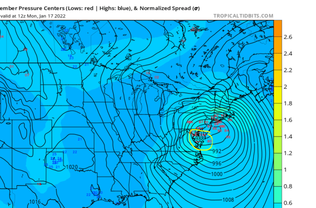
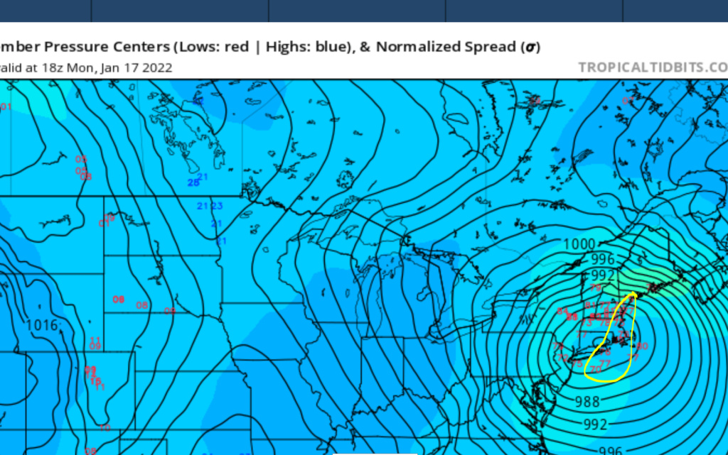
Who is to say at this juncture with the energy not fully sampled or onshore it is not going to happen as stated above? Many thought OTS was happening as of Sunday, others a massive snowstorm, Friday's storm was some OTS and others menial and we had a big NW jump in teh last 36 hours. If that kicker speeds up and the storm is later phasing or both happen the landscape changes.
Just putting it out there. Time will tell about 50 hour still this all starts.
Paul Dorian has an interesting write up:
https://arcfieldweather.com/blog/2022/1/14/1030-am-significant-storm-to-impact-the-eastern-us-from-sunday-into-mondaysnow-ice-rain-coastal-flooding-damaging-winds-all-on-the-tablefront-end-accumulating-snowice-for-i-95-corridor
_________________
Mugs
AKA:King: Snow Weenie
Self Proclaimed
WINTER 2014-15 : 55.12" +.02 for 6 coatings (avg. 35")
WINTER 2015-16 Total - 29.8" (Avg 35")
WINTER 2016-17 : 39.5" so far

amugs- Advanced Forecaster - Mod

- Posts : 15091
Reputation : 213
Join date : 2013-01-07
Age : 54
Location : Hillsdale,NJ
CPcantmeasuresnow and Grselig like this post
 Re: Momentum building for possible storm on JAN 16th?
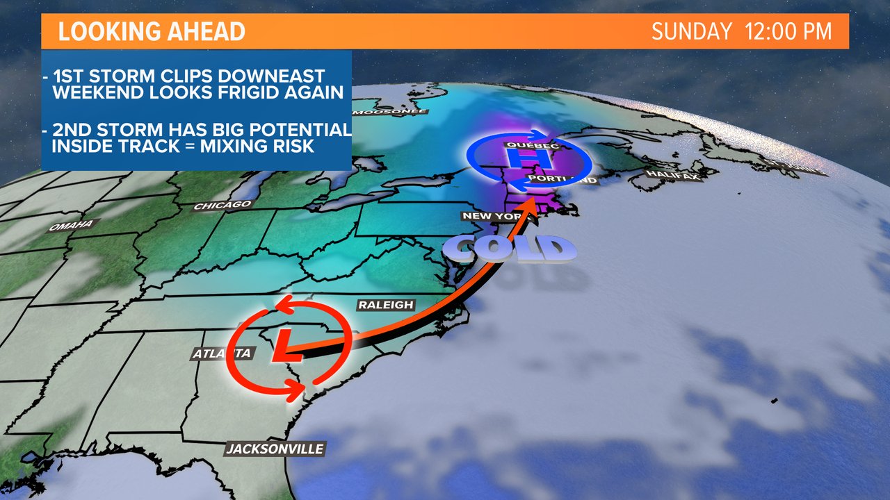
This track would help from the Driscoll on N and especially the HV, NW Nj and EPA overall with more snow than rain but icing may be a tad more due to the warm layer off the ocean.

_________________
Mugs
AKA:King: Snow Weenie
Self Proclaimed
WINTER 2014-15 : 55.12" +.02 for 6 coatings (avg. 35")
WINTER 2015-16 Total - 29.8" (Avg 35")
WINTER 2016-17 : 39.5" so far

amugs- Advanced Forecaster - Mod

- Posts : 15091
Reputation : 213
Join date : 2013-01-07
Age : 54
Location : Hillsdale,NJ
 Re: Momentum building for possible storm on JAN 16th?
heehaw453 wrote:sroc4 wrote:heehaw453 wrote:A point that I have brought up before is I don't really have a good precedent of an ULL going south of Atlanta and then becoming an inland runner. It's really kind of extreme to do that. Even the 93 superstorm I don't believe ran that far inland more of extreme coastal hugger. Then again a lot of storms don't have TPV sling shot action like this one.
The main 500mb closes and matures so early that the mid level lows get pulled underneath and you begin getting the occluded situation. Obv when the upper and mid level centers start to align you end up pulling the SLP west along with it. Bottom line any time ewe get phasing energy in the middle of the country unless there is a mechanism (which we dont) to keep it suppressed it raises heights too quickly and we get warm sectored.
I agree but the main culprit IMO is the tpv sling shot effect. There have been ULLs that close off before early. But when they pass underneath Atlanta I can't find an analog where we get an inland runner. Not much resistance of course is like a perfect setup for something like this occur. It's a interesting use case for sure.
Frank there is no doubt that the lack of a decent -NAO, call it east based vs IMO a weak -NAO that is in rapid retreat, that isnt helping at all. That said when have we ever really needed a -NAO for a big event. The -NAO is the most over rated tele out there...IMHO of course. The neg NAO is what takes a 6-12" or 12-18" and makes it truly special. For me there is a different main culprit here, and heehaw I dont think its the TPV thats causing the sling shot.
You have two pieces of energy coming together in the Ok KS area, phasing and becoming a strong cut off ULL. This alone forming in this location typically leads to rapid height rises along the EC such that the storm track more often than not is west. That is of course without help from other players. From there it dips into the Deep South and reaches its apparent southern most lat before making the turn. Unfort in most instances when you get energy this strong, esp when the atlantic is less than ideal, we need something to suppress heights out ahead or you get the insurgence of the warm air at the mid levels and a storm track west.
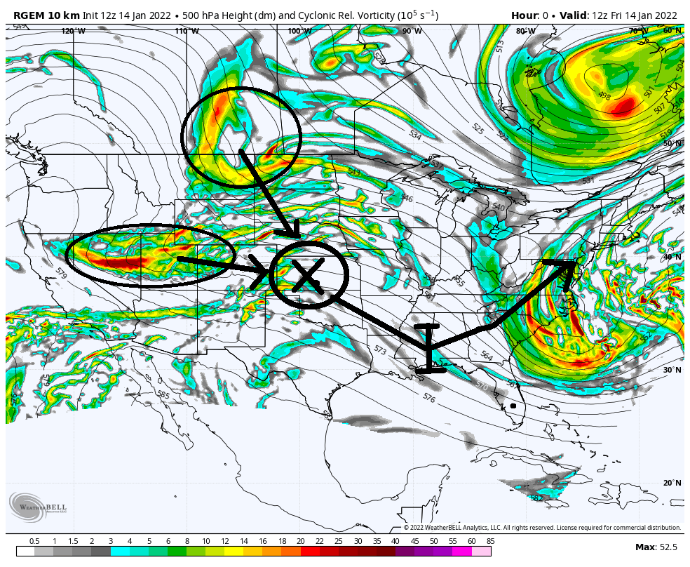
But IMO the main culprit, although there seems to be several, is the trailing s/w I have circled below as our system reaches the deep south. Because of its trajectory diving SE and its relative proximity to our ULL, it is acting to create the focal or pivot point for which the main ULL travels from there(NE). It needed to be further east (blue circle) at this junture, which would have caused it to cont to guide the system further East, before eventually meeting with and tilting the trajectory to the NE a little later.
Either that or like I said in prev posts the TPV needed to be sitting further east to suppress the heights. Either scenario would have allow the confluence to hold on just a little longer. But again as is currently modeled the timing and position of the trailing S/W is triggering the ULL trajectory to the west of us; consequently our mid level and SLP's.

_________________
"In weather and in life, there's no winning and losing; there's only winning and learning."
WINTER 2012/2013 TOTALS 43.65"WINTER 2017/2018 TOTALS 62.85" WINTER 2022/2023 TOTALS 4.9"
WINTER 2013/2014 TOTALS 64.85"WINTER 2018/2019 TOTALS 14.25" WINTER 2023/2024 TOTALS 13.1"
WINTER 2014/2015 TOTALS 71.20"WINTER 2019/2020 TOTALS 6.35"
WINTER 2015/2016 TOTALS 35.00"WINTER 2020/2021 TOTALS 37.75"
WINTER 2016/2017 TOTALS 42.25"WINTER 2021/2022 TOTALS 31.65"

sroc4- Admin

- Posts : 8331
Reputation : 301
Join date : 2013-01-07
Location : Wading River, LI
CPcantmeasuresnow likes this post
 Re: Momentum building for possible storm on JAN 16th?
sroc4 wrote:Man I wish I can devote more time to maps and analysis along side you guys. You all are doing a phenomenal job BTw. I will say this. Frank makes a great point regarding what’s happening in the Atlantic with HP and 50/50 low position etc. that said I really think there are still other ways to avoid the cut but it makes things have to be even more perfectly timed. In general I personally don’t like an earlier phase at all; esp with the Atlantic currently trending the way it is. If we assume the Atlantic trends maintain or get worse then the more phasing and/or the stronger the initial system is the quicker and easier heights out ahead are going to lift into the coastal plain and there will be no resistance to prevent it from cutting and really driving the warm air into the mid levels. So instead I think what we need is to look at the energy behind the main system and the syst6em itself. Rather than phase, which classically turns the system up as the trough goes negative, maybe the trailing energy comes in a little faster and further north such that we would get it to steer the system further south and east as we typically see when the pattern is more progressive, again rather than phase into the back of it which raises heights. We do need it to phase but it has to be a little later to prevent the early cut west with the stronger system and less than perfect Atlantic. Yup Baby bear. The more east based the NAO, the more “progressive” the flow becomes off the coast(relatively speaking). As that happens then we need to start looking at the pacific and hope for a weaker system and/or a later phase.
Timing and strength of all the energy involved with the system itself, out in front of the system, and behind the system is far from know yet. Heck. The energy that is Friday’s apparent swing and miss system is just this morning coming onshore in northern Canada this morning(which I still think eastern sections has a shot at this one). The energy behind our Monday system is even further out so it’s exact strength and timing with respect to our system is far from known.
For now we let the weenies jump and we sit back and watch, then we will start to see how the modeling actually evolves. I agree with heehaw where this may be one of those situations where literally within 36 hours models are walking the track to its final destination.
Focus on the bold and underlined statements above. Several of us made them earlier in the week, and Ray made it again today specifically with regards to the trailing energy I highlighted in my above post. We are still >48hr out so I still believe that we will get a last minute, starting with tomorrows 12z, (maybe 00z tonight), slow but steady "walking" to the final destination for our system....for better OR worse. I think watching the trend with TPV dropping in from the N Tundra, and the trailing energy entering the WC of NA will tell us if we trend a bit more favorable or not.
_________________
"In weather and in life, there's no winning and losing; there's only winning and learning."
WINTER 2012/2013 TOTALS 43.65"WINTER 2017/2018 TOTALS 62.85" WINTER 2022/2023 TOTALS 4.9"
WINTER 2013/2014 TOTALS 64.85"WINTER 2018/2019 TOTALS 14.25" WINTER 2023/2024 TOTALS 13.1"
WINTER 2014/2015 TOTALS 71.20"WINTER 2019/2020 TOTALS 6.35"
WINTER 2015/2016 TOTALS 35.00"WINTER 2020/2021 TOTALS 37.75"
WINTER 2016/2017 TOTALS 42.25"WINTER 2021/2022 TOTALS 31.65"

sroc4- Admin

- Posts : 8331
Reputation : 301
Join date : 2013-01-07
Location : Wading River, LI
CPcantmeasuresnow likes this post
 Re: Momentum building for possible storm on JAN 16th?
BEAST!! Euro going colder and dragging in more cold air from above - helps again with Snow and yes ice in the aforementioned regions. The purple is very impressive deepening offshore which will help drag down the cold air - it is more SE and helps from the changeover for a bit before it happens
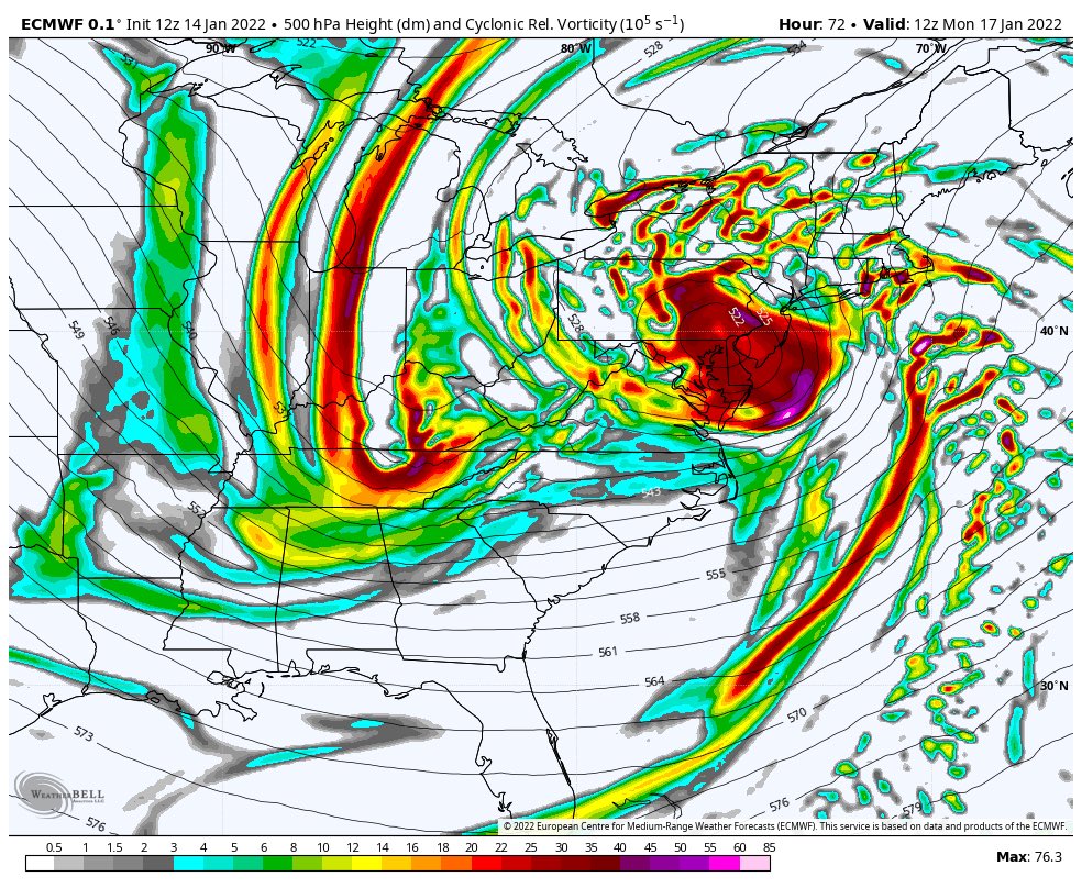
@SROC energies aren't on the field for a while and hence what you, I and Rb (sorry if I missed anyone) have said just like Fridays storm. This is a tough forecast and the NAO head faking us to a degree isn't helping. The GEFS spread still has me intrigued on my track call from yesterday.

@SROC energies aren't on the field for a while and hence what you, I and Rb (sorry if I missed anyone) have said just like Fridays storm. This is a tough forecast and the NAO head faking us to a degree isn't helping. The GEFS spread still has me intrigued on my track call from yesterday.
Last edited by amugs on Fri Jan 14, 2022 2:02 pm; edited 1 time in total
_________________
Mugs
AKA:King: Snow Weenie
Self Proclaimed
WINTER 2014-15 : 55.12" +.02 for 6 coatings (avg. 35")
WINTER 2015-16 Total - 29.8" (Avg 35")
WINTER 2016-17 : 39.5" so far

amugs- Advanced Forecaster - Mod

- Posts : 15091
Reputation : 213
Join date : 2013-01-07
Age : 54
Location : Hillsdale,NJ
 Re: Momentum building for possible storm on JAN 16th?
The operative phrase is "a bit",correct? Do you expect any drastic changes at this point, good or bad, i.e. I-95 corridor or long island gets an all snow event
lglickman1- Pro Enthusiast

- Posts : 319
Reputation : 0
Join date : 2013-02-05
Location : New Rochelle, NY
 Re: Momentum building for possible storm on JAN 16th?
lglickman1 wrote:The operative phrase is "a bit",correct? Do you expect any drastic changes at this point, good or bad, i.e. I-95 corridor or long island gets an all snow event
The chances of the coastal plain getting an all snow or even MAJOR snowstorm is very small. But for areas NW I think there is still hope.
_________________
"In weather and in life, there's no winning and losing; there's only winning and learning."
WINTER 2012/2013 TOTALS 43.65"WINTER 2017/2018 TOTALS 62.85" WINTER 2022/2023 TOTALS 4.9"
WINTER 2013/2014 TOTALS 64.85"WINTER 2018/2019 TOTALS 14.25" WINTER 2023/2024 TOTALS 13.1"
WINTER 2014/2015 TOTALS 71.20"WINTER 2019/2020 TOTALS 6.35"
WINTER 2015/2016 TOTALS 35.00"WINTER 2020/2021 TOTALS 37.75"
WINTER 2016/2017 TOTALS 42.25"WINTER 2021/2022 TOTALS 31.65"

sroc4- Admin

- Posts : 8331
Reputation : 301
Join date : 2013-01-07
Location : Wading River, LI
 Re: Momentum building for possible storm on JAN 16th?
lglickman1 wrote:The operative phrase is "a bit",correct? Do you expect any drastic changes at this point, good or bad, i.e. I-95 corridor or long island gets an all snow event
Glick it woudl have to be a drastic change at this point for the entire i 95 corridor and LI to be all snow - like a 200 mile move SE from what we are seeing now on OP model runs. IF the far LP on teh GEFS outside of my yellow circle I posted come to fruition then there is slim chance but I guess that is all some need.
_________________
Mugs
AKA:King: Snow Weenie
Self Proclaimed
WINTER 2014-15 : 55.12" +.02 for 6 coatings (avg. 35")
WINTER 2015-16 Total - 29.8" (Avg 35")
WINTER 2016-17 : 39.5" so far

amugs- Advanced Forecaster - Mod

- Posts : 15091
Reputation : 213
Join date : 2013-01-07
Age : 54
Location : Hillsdale,NJ
sroc4 likes this post
 Re: Momentum building for possible storm on JAN 16th?
Is there still hope for NYC or we getting snow sleet and rain
frank 638- Senior Enthusiast

- Posts : 2823
Reputation : 37
Join date : 2016-01-01
Age : 40
Location : bronx ny
 Re: Momentum building for possible storm on JAN 16th?
frank 638 wrote:Is there still hope for NYC or we getting snow sleet and rain
Unfortunately, Looks like the latter
lglickman1- Pro Enthusiast

- Posts : 319
Reputation : 0
Join date : 2013-02-05
Location : New Rochelle, NY
 Re: Momentum building for possible storm on JAN 16th?
frank 638 wrote:Is there still hope for NYC or we getting snow sleet and rain
There is always hope Frank. Always. In this case Id hope for "less" sleet and rain and more snow, but expect sleet and rain regardless.
_________________
"In weather and in life, there's no winning and losing; there's only winning and learning."
WINTER 2012/2013 TOTALS 43.65"WINTER 2017/2018 TOTALS 62.85" WINTER 2022/2023 TOTALS 4.9"
WINTER 2013/2014 TOTALS 64.85"WINTER 2018/2019 TOTALS 14.25" WINTER 2023/2024 TOTALS 13.1"
WINTER 2014/2015 TOTALS 71.20"WINTER 2019/2020 TOTALS 6.35"
WINTER 2015/2016 TOTALS 35.00"WINTER 2020/2021 TOTALS 37.75"
WINTER 2016/2017 TOTALS 42.25"WINTER 2021/2022 TOTALS 31.65"

sroc4- Admin

- Posts : 8331
Reputation : 301
Join date : 2013-01-07
Location : Wading River, LI
 Re: Momentum building for possible storm on JAN 16th?
Who knows maybe there’s a miraclesroc4 wrote:frank 638 wrote:Is there still hope for NYC or we getting snow sleet and rain
There is always hope Frank. Always. In this case Id hope for "less" sleet and rain and more snow, but expect sleet and rain regardless.
frank 638- Senior Enthusiast

- Posts : 2823
Reputation : 37
Join date : 2016-01-01
Age : 40
Location : bronx ny
sroc4 and phil155 like this post
 Re: Momentum building for possible storm on JAN 16th?
amugs wrote:This track would help from the Driscoll on N and especially the HV, NW Nj and EPA overall with more snow than rain but icing may be a tad more due to the warm layer off the ocean.
Very misleading graphic. The surface low may very well take this track, but the ULL is what matters most and unfortunately I don't see any model showing the ULL tracking offshore. Your mid levels are tainted. Also, the HP is slipping east. There's no mechanism to hold it in place.
_________________
_______________________________________________________________________________________________________
CLICK HERE to view NJ Strong Snowstorm Classifications
amugs likes this post
 Re: Momentum building for possible storm on JAN 16th?
Yep. Unless you see about 100 miles SE trajectory of the ULL and its mid-level pieces are stacked nicely underneath it this will be an I-81 special. The surface low track is really just a reflection of the ULL direction. There are a myriad of factors bringing the ULL more NNE rather than NE and there is good debate on the reasons. This is a very interesting trajectory for an ULL of that there can be no doubt. That is one reason why I think there could be some wiggle room.
heehaw453- Advanced Forecaster

- Posts : 3904
Reputation : 86
Join date : 2014-01-20
Location : Bedminster Township, PA Elevation 600' ASL
 Re: Momentum building for possible storm on JAN 16th?
Well you know a storm is basically doa when ur about 2 1/2 days out and not many posts, though 15 pages is pretty good for a storm that may not produce for most.

jmanley32- Senior Enthusiast

- Posts : 20512
Reputation : 108
Join date : 2013-12-12
Age : 42
Location : Yonkers, NY
 Re: Momentum building for possible storm on JAN 16th?
How far north of NYC do you think you will have to be to get into the more snowy scenario if this can stay SE a bit? Do you think I stand any chance at all or will it be mainly rain? And I am going to be selfish for a minute and would rather see it make a wide right and stay dry and what appears to potentially be warmer weather with the onshore flow.sroc4 wrote:lglickman1 wrote:The operative phrase is "a bit",correct? Do you expect any drastic changes at this point, good or bad, i.e. I-95 corridor or long island gets an all snow event
The chances of the coastal plain getting an all snow or even MAJOR snowstorm is very small. But for areas NW I think there is still hope.

jmanley32- Senior Enthusiast

- Posts : 20512
Reputation : 108
Join date : 2013-12-12
Age : 42
Location : Yonkers, NY
 Re: Momentum building for possible storm on JAN 16th?
jmanley32 wrote:Well you know a storm is basically doa when ur about 2 1/2 days out and not many posts, though 15 pages is pretty good for a storm that may not produce for most.
Yep, not a single post about the 18z... must be bad....

mikeypizano- Pro Enthusiast

- Posts : 1118
Reputation : 66
Join date : 2017-01-05
Age : 35
Location : Wilkes-Barre/Scranton, PA
RJB8525 likes this post
 Re: Momentum building for possible storm on JAN 16th?
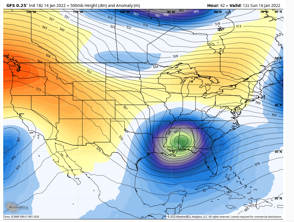
The GFS ULL tickles the GOM. LoL. The short wave is about to bust right through the ridge. That's about a deep a dig as you're going to see. It is extremely bad luck that something like this isn't going to pound the area with a full blown blizzard. very hard to wrap my head around that kind of depth running inland.

heehaw453- Advanced Forecaster

- Posts : 3904
Reputation : 86
Join date : 2014-01-20
Location : Bedminster Township, PA Elevation 600' ASL
amugs likes this post
 Re: Momentum building for possible storm on JAN 16th?
Is it possible we get a last minute 24 hr surprise like boxing day blizzard which was supposed to be a miss? I know not same set up but in terms of guidance doing a complete flip. I agree how does it dive that far south and not bring a blizzard that looks classic.heehaw453 wrote:The GFS ULL tickles the GOM. LoL. The short wave is about to bust right through the ridge. That's about a deep a dig as you're going to see. It is extremely bad luck that something like this isn't going to pound the area with a full blown blizzard. very hard to wrap my head around that kind of depth running inland.

jmanley32- Senior Enthusiast

- Posts : 20512
Reputation : 108
Join date : 2013-12-12
Age : 42
Location : Yonkers, NY
Page 15 of 23 •  1 ... 9 ... 14, 15, 16 ... 19 ... 23
Page 15 of 23
Permissions in this forum:
You cannot reply to topics in this forum|
|
|

 Home
Home