Long Range Thread 25.0
Page 7 of 40 •  1 ... 6, 7, 8 ... 23 ... 40
 Re: Long Range Thread 25.0
sroc4 wrote:Irish wrote:And the pull back from optimism begins...
Nah. Pulling back off from blind optimism. Back to about cautious optimism. Btw hats off on the Cowgirls win.
I see, makes sense. Thank you, definitely a good win. Eagles have the division right now but I think we can beat them, at the very least, compete with them.
Irish- Pro Enthusiast

- Posts : 788
Join date : 2019-01-16
sroc4 likes this post
 Re: Long Range Thread 25.0
The voice of reasonsroc4 wrote:Irish wrote:And the pull back from optimism begins...
Nah. Pulling back off from blind optimism. Back to about cautious optimism. Btw hats off on the Cowgirls win.
heehaw453- Advanced Forecaster

- Posts : 3904
Join date : 2014-01-20
sroc4 and MattyICE like this post
 Re: Long Range Thread 25.0
heehaw453 wrote:The voice of reasonsroc4 wrote:Irish wrote:And the pull back from optimism begins...
Nah. Pulling back off from blind optimism. Back to about cautious optimism. Btw hats off on the Cowgirls win.. Thanks for your detailed write-up as always. I'm still very optimistic that some folks in this forum will be happy with December.
Fly Eagles Fly !!!!!!!!
snowbunny- Posts : 3
Reputation : 0
Join date : 2021-12-25
 Re: Long Range Thread 25.0
heehaw453- Advanced Forecaster

- Posts : 3904
Reputation : 86
Join date : 2014-01-20
Location : Bedminster Township, PA Elevation 600' ASL
 Re: Long Range Thread 25.0

dkodgis- Senior Enthusiast

- Posts : 2492
Reputation : 98
Join date : 2013-12-29
heehaw453 likes this post
 Re: Long Range Thread 25.0
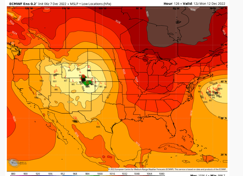
I favor NW I95 for this due to antecedent air mass not being deeply cold. Euro and its EPS have been fairly consistent on this. It's still too far out to take too seriously but bears watching. Light to perhaps moderate potential IMO.
heehaw453- Advanced Forecaster

- Posts : 3904
Reputation : 86
Join date : 2014-01-20
Location : Bedminster Township, PA Elevation 600' ASL
 Re: Long Range Thread 25.0
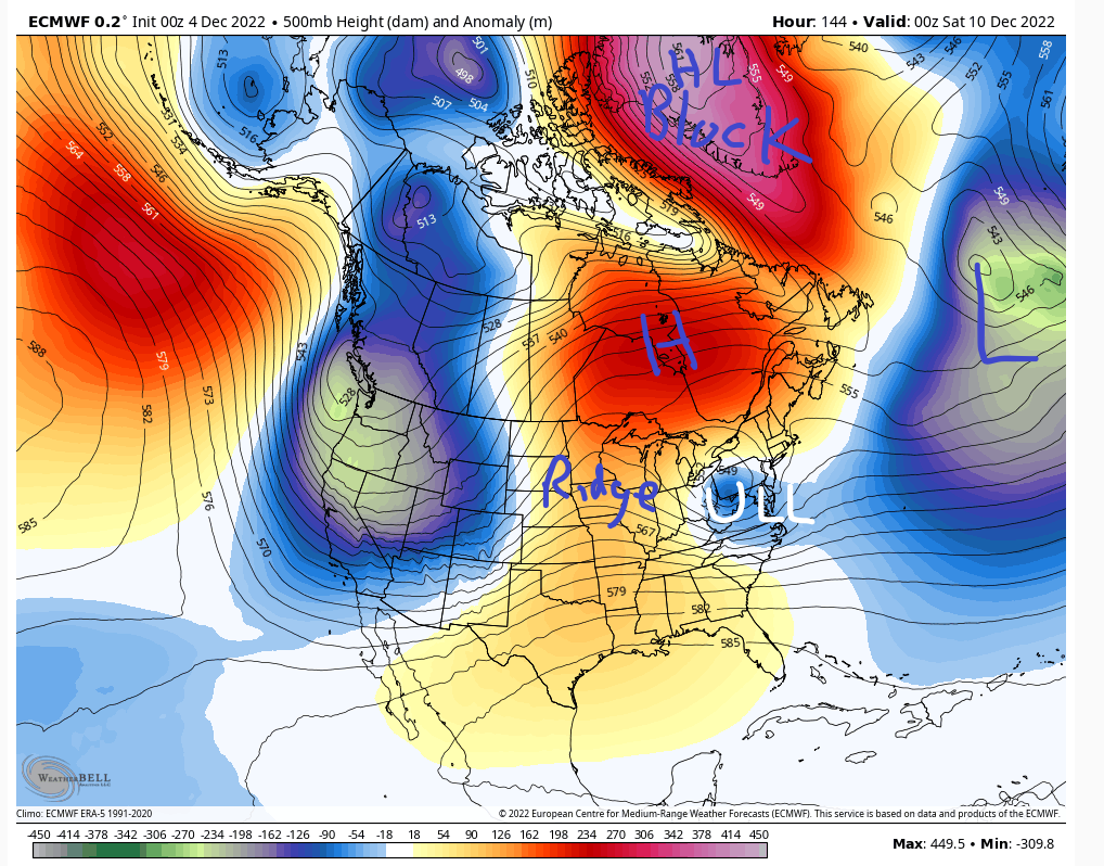
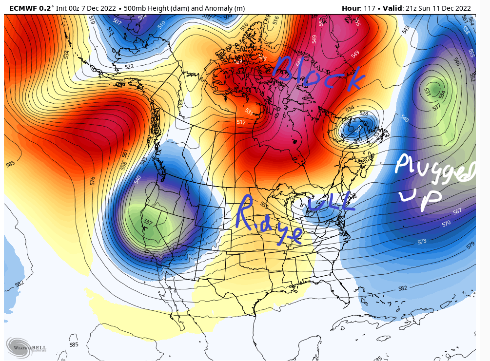
heehaw453 wrote:The Euro depiction of 12/10 shows a very stout HP in Quebec pinned under HL blocking and another H starting to banana out. The ULL has no choice but to go underneath. The atmosphere gets plugged up when the HL blocking sets in. The AO supplying the cold air via the cold high pressure from the arctic. This is why I get excited with a good Atlantic/Arctic. It only takes a window for a ridge to pop to give us a chance. With progressive Atlantic patterns, i.e, w/out the Atlantic blocking you usually need more amplification much further west to have a chance and it's much more thread the needle.
I favor NW I95 for this due to antecedent air mass not being deeply cold. Euro and its EPS have been fairly consistent on this. It's still too far out to take too seriously but bears watching. Light to perhaps moderate potential IMO.
Hmmm. You make some great points here that causes an ear to go up for sure. That said I think there are a few things to point out that need to be over come.
First the air mass to our north really isn't arctic or even polar in its origin. Its more of a modified Pac air mass. By looking at the 500mb wind maps valid for hr 144, the same time stamp as the map you show above, that's the case.

That said as you point out there is a stout (1044 verbatim)HP situated to our north, and a bottle neck in the N Atlantic complimentary of our -NAO. This should prevent that ULL and resulting slp from simply passing well to our west into the GL bringing the warm surge. Instead the result should force a transfer of the surface low pressure(slp) as it heads through the Ohio valley and NW Pa somewhere to our south off the Atlantic coast. As depicted verbatim by last nights 00z euro it develops right off the DelMarVa.
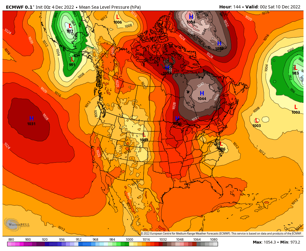
At first glance a developing slp off the Delmarva with a stout HP to the N is normally EXACTLY what we want to see. But the devil is in the details. If we zoom in a little on the MSLP map, see below, you see that the positioning of the HP is a bit too far east. This results in an E to ENE fetch.

So again verbatim this will lead to our surface and mid levels to have wind directions coming off the ocean which is never a good thing. Again esp because our airmass to the north isn't arctic, it's modified pacific. First image shows the surface temps as the slp comes off the Delmarva, again hr 144. You can see there is a rather large contrast in temps along the coast vs just inland. Second image shows the 850mb winds. As you can see they are screaming in from the ENE. And third and fourth images are the 850 mb temps, hr 144 and the next frame hr 150, which shows how the mid levels warm to above freezing, esp along the coast, pretty quickly.

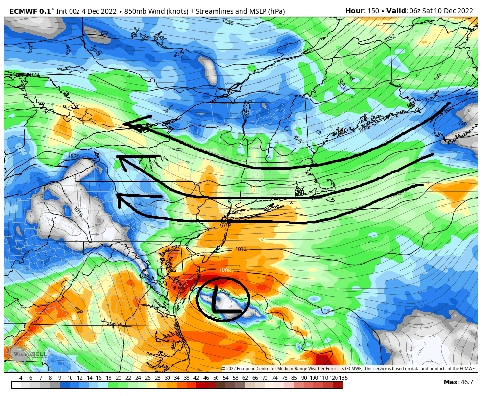
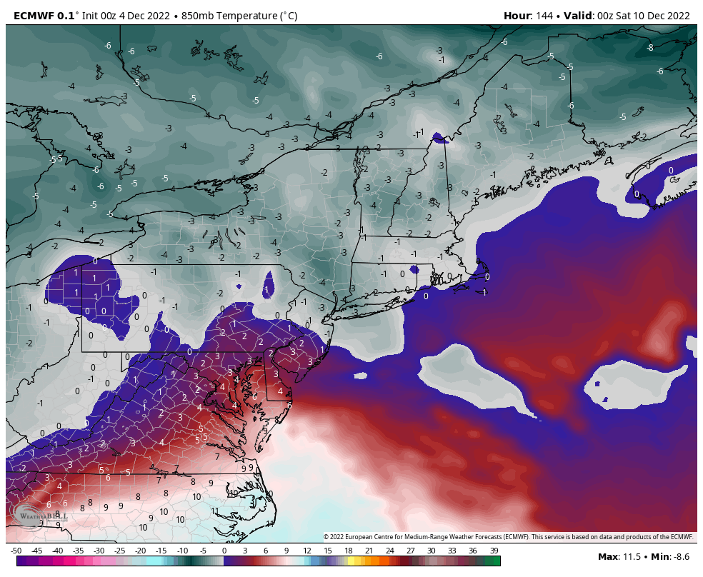
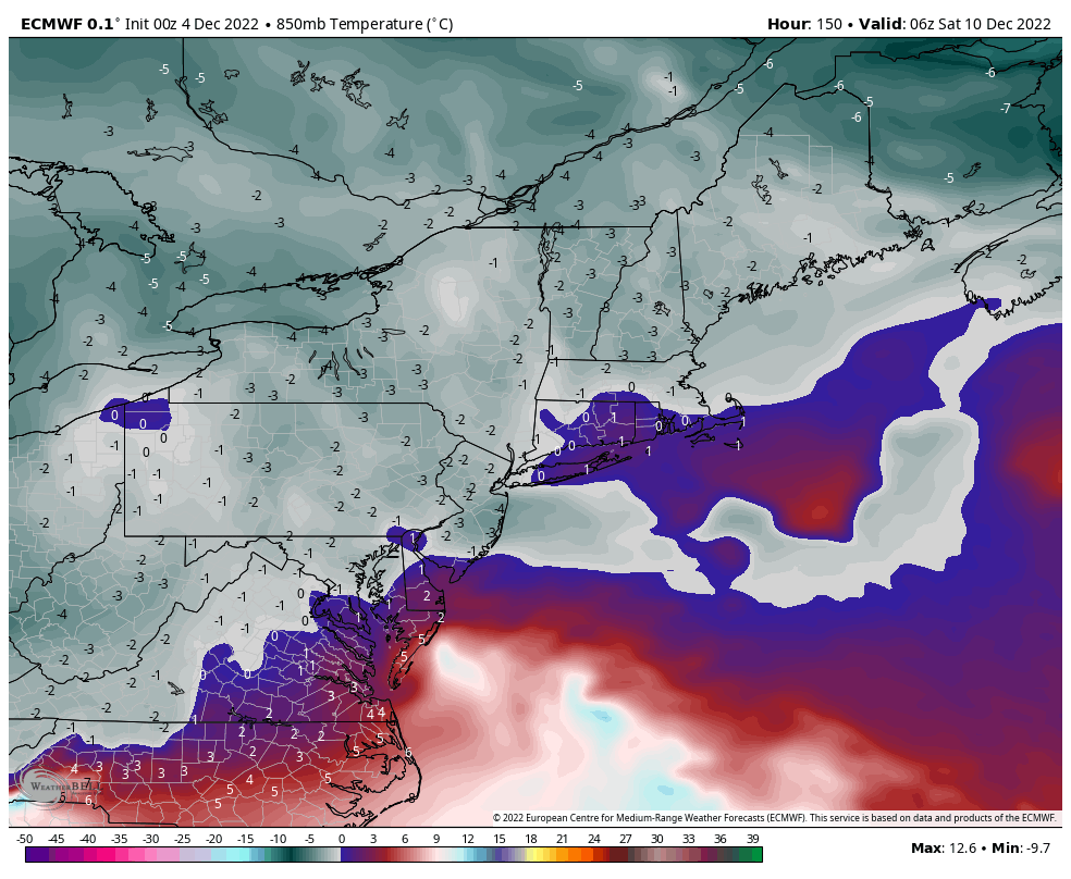
Now here is the thing. This far out still, 6days +/-, trying to read too much into the details of the temp profiles at the surface and mid levels, and the exact positioning of the HP and slp etc is futile as the upper level details are still evolving. As we all know we DO NOT need 20*F temps area wide for it to snow. All we need is "Cold Enough".
A simple shift of that HP north vs west vs east a tad, or how far north the primary slp gets before transferring vs an earlier transfer off the coast, and details of the outcome change dramatically. As you can plainly see the freezing line at 850 is right there. Heehaw as you stated above, areas N&W off the coast have a much higher chance at pulling some white out of this than does the coastal plain but no-one is out of the game just yet. That said a warmer soln for all is also on the table, as is the dreaded freezing rain solns for interior sections if those mid levels warm but the surface temps hold on below freezing which is def a possibly given the set up.
Its something to track for sure. Hopefully many more to come as well.
_________________
"In weather and in life, there's no winning and losing; there's only winning and learning."
WINTER 2012/2013 TOTALS 43.65"WINTER 2017/2018 TOTALS 62.85" WINTER 2022/2023 TOTALS 4.9"
WINTER 2013/2014 TOTALS 64.85"WINTER 2018/2019 TOTALS 14.25" WINTER 2023/2024 TOTALS 13.1"
WINTER 2014/2015 TOTALS 71.20"WINTER 2019/2020 TOTALS 6.35"
WINTER 2015/2016 TOTALS 35.00"WINTER 2020/2021 TOTALS 37.75"
WINTER 2016/2017 TOTALS 42.25"WINTER 2021/2022 TOTALS 31.65"

sroc4- Admin

- Posts : 8331
Reputation : 301
Join date : 2013-01-07
Location : Wading River, LI
SENJsnowman likes this post
 Re: Long Range Thread 25.0


heehaw453- Advanced Forecaster

- Posts : 3904
Reputation : 86
Join date : 2014-01-20
Location : Bedminster Township, PA Elevation 600' ASL
sroc4 likes this post
 Re: Long Range Thread 25.0

heehaw453- Advanced Forecaster

- Posts : 3904
Reputation : 86
Join date : 2014-01-20
Location : Bedminster Township, PA Elevation 600' ASL
sroc4 likes this post
 Re: Long Range Thread 25.0
MattyICE- Advanced Forecaster

- Posts : 249
Reputation : 6
Join date : 2017-11-10
Age : 38
Location : Clifton, NJ (Eastern Passaic County)
snowbunny likes this post
 Re: Long Range Thread 25.0
I know some may say you were touting a change and possible snwow event with this next system - yes that is true and every model & everyone pro met to amatuers for a few days last week where showing such and discussing. What has happened? Lot's and lets put it simple that the blocks, east and west are not there yet and forming at the 500mb in the coming days. THE NAO block is real and when it gets here let it do its thing.
On a more imnportant note the GFS has been so wrong lately after the upgrade and they are asking for input and looking into this: money well spent again (sarcasm!). Th etropical compenent aspect and caculations are offf as has been noted by Bastardi, Bentley and Margarave as well as other pro Mets.
Information on what was included in the recent GFS upgrade from v16.2 to v16.3 can be found here:https://t.co/59dRA5wMAz
— Dr. Alicia M Bentley (@AliciaMBentley) December 4, 2022
If you're seeing issues associated with this (or another) model, please email examples to the EMC Model Evaluation Group (MEG):https://t.co/Mxv3wPvZur pic.twitter.com/fUTeJzmUkZ
So I would seriously caution and not use tihs model moving forward.
As we have seen so many time models have a hell of a time with the pattern in the LR and mid range with the transition of the seasons and patterns. They have notoriously rushed and missed the synoptic set up.
Now we are we seeing out west that starts this weekend that shows promise, an EAMT (East Asian Mountain Torque) that becomes more favorable and helps with the pattern in the pacific set up blocking.

2 black circles show the LOW pressures are no longer present and the jet streak is not raging off the Asian coast. Strong but not raging, need to look half full here peeps you are not stopping the PAC but neeed to ammend it as best one can!
NAO block retrogarde over (from blizzard on USAwx forum)

and then once it ridge bridges with the EPO and they hook - it says the WC trough .........GET OUT OF HERE SUCKER!!

Point out we have snowed in MUCH worse patters and everyone says boy did we thread the needle yada yada BUT reemember this, we avergae 30" plus of snow a season, me I'm at 34" and have bascially hit that or superceded with a 2 winters coming in less than that in the 12 years I have been recording (11-12, last year) snowfall.
We'll see where are at come midweek and later this week to where tihs is going.
_________________
Mugs
AKA:King: Snow Weenie
Self Proclaimed
WINTER 2014-15 : 55.12" +.02 for 6 coatings (avg. 35")
WINTER 2015-16 Total - 29.8" (Avg 35")
WINTER 2016-17 : 39.5" so far

amugs- Advanced Forecaster - Mod

- Posts : 15091
Reputation : 213
Join date : 2013-01-07
Age : 54
Location : Hillsdale,NJ
SENJsnowman and MattyICE like this post
 Re: Long Range Thread 25.0
_________________
Mugs
AKA:King: Snow Weenie
Self Proclaimed
WINTER 2014-15 : 55.12" +.02 for 6 coatings (avg. 35")
WINTER 2015-16 Total - 29.8" (Avg 35")
WINTER 2016-17 : 39.5" so far

amugs- Advanced Forecaster - Mod

- Posts : 15091
Reputation : 213
Join date : 2013-01-07
Age : 54
Location : Hillsdale,NJ
phil155 likes this post
 Re: Long Range Thread 25.0
What have we learned from prev discussions folks? Look at the area South of the Aleutian Islands. What are we seeing? Negatives(cool colors) aka hints at a trough. What does this mean? Positives extending north into Alaska, aka the -EPO domain. What does this mean? We start to erase negatives, ie: trough along the west coast of Canada and N CONUS. THIS!! Is what we need to see. This will prevent the Pac and STJ jets from dominating across the country and flooding it with Warm air. This will allow the arctic air mass to make it far enough south to really matter. This combined with the neg NAO has the potential to be amazing. That said the negative NAO by itself is one of the most over rated teleconnections IMHO. It almost always needs some other influences in order to bring out the true magic of its potential for snow in the NE. GEFS at this hr not quite there but they eventually make it there by the end of the run. There is alot to be excited about with this look. But...........
..........But this is still 14-15days out. This is the LR ensembles. Will this end up just being another mirage in the end, or will this turn out to be a cold and snowy oasis?
I am almost always a glass half full guy, and I make no exception here. The teles are pointingtowards another -EPO and the PNA is starting to trend into positive territory, but again its a long way off so temper expectations for now. I will wait patiently with cautious optimism.


_________________
"In weather and in life, there's no winning and losing; there's only winning and learning."
WINTER 2012/2013 TOTALS 43.65"WINTER 2017/2018 TOTALS 62.85" WINTER 2022/2023 TOTALS 4.9"
WINTER 2013/2014 TOTALS 64.85"WINTER 2018/2019 TOTALS 14.25" WINTER 2023/2024 TOTALS 13.1"
WINTER 2014/2015 TOTALS 71.20"WINTER 2019/2020 TOTALS 6.35"
WINTER 2015/2016 TOTALS 35.00"WINTER 2020/2021 TOTALS 37.75"
WINTER 2016/2017 TOTALS 42.25"WINTER 2021/2022 TOTALS 31.65"

sroc4- Admin

- Posts : 8331
Reputation : 301
Join date : 2013-01-07
Location : Wading River, LI
kalleg and MattyICE like this post
heehaw453- Advanced Forecaster

- Posts : 3904
Reputation : 86
Join date : 2014-01-20
Location : Bedminster Township, PA Elevation 600' ASL
amugs likes this post
 Re: Long Range Thread 25.0


Beyond the CPC, however, the 500 mb pattern on the EURO ensemble mean reflects how the west coast trough is causing ridging in the east, despite the -NAO/-AO couplet. Here is the Normalized 500 mb mean at 12Z for both the 6-10 day and 11-15 day timeframes:


And here the the GEFS PNA projection:

In order for the east coast to have a chance at anything good, you need the PNA to get out of the negative phase. Until then, it's going to be cutters followed by brief cold snaps. As the chart above illustrates, the PNA may turn neutral in a couple of weeks. I'll believe it when I see it though.
Math23x7- Wx Statistician Guru

- Posts : 2379
Reputation : 68
Join date : 2013-01-08
 Re: Long Range Thread 25.0
False. The most important factor for snow for us is the Arctic Oscillation. Don s. Bluewave and psu Hoffman on American weather have numerous stats showing this. Any how peeps get ready for some wild winter weather in the next few weeks models are now starting to figure things out. Last night's guidance was great. First threat this weekendMath23x7 wrote:If there's one thing I've learned in all my years of weather tracking, it's that when it comes to snow/cold in the east: The PNA/EPO supersede the NAO/AO. The NAO and AO are both super negative at the moment, but the -PNA is hurting our weather pattern. The CPC is aware of this with the 6 to 10 and 8 to 14 day temperature outlooks:
Beyond the CPC, however, the 500 mb pattern on the EURO ensemble mean reflects how the west coast trough is causing ridging in the east, despite the -NAO/-AO couplet. Here is the Normalized 500 mb mean at 12Z for both the 6-10 day and 11-15 day timeframes:
And here the the GEFS PNA projection:
In order for the east coast to have a chance at anything good, you need the PNA to get out of the negative phase. Until then, it's going to be cutters followed by brief cold snaps. As the chart above illustrates, the PNA may turn neutral in a couple of weeks. I'll believe it when I see it though.

algae888- Advanced Forecaster

- Posts : 5311
Reputation : 46
Join date : 2013-02-05
Age : 61
Location : mt. vernon, new york
 Re: Long Range Thread 25.0

docstox12- Wx Statistician Guru

- Posts : 8497
Reputation : 222
Join date : 2013-01-07
Age : 73
Location : Monroe NY
 Re: Long Range Thread 25.0
heehaw453- Advanced Forecaster

- Posts : 3904
Reputation : 86
Join date : 2014-01-20
Location : Bedminster Township, PA Elevation 600' ASL
 Re: Long Range Thread 25.0
"The latest guidance suggests that the AO could fall to -3.000 or below during the second week of December. Since 1950, there were 24 cases that saw the AO reach -3.000 or below during December. Mean snowfall for those cases was 6.2" (Median: 6.0"). 50% of such cases saw December wind up with 6.0" or more snow (25% saw 10.0" or more). In contrast, during all other December cases, mean December snowfall was 3.5" (Median: 2.5"). In those cases, 21% of years saw December snowfall of 6.0" or more while 8% saw 10.0" or more snowfall."

algae888- Advanced Forecaster

- Posts : 5311
Reputation : 46
Join date : 2013-02-05
Age : 61
Location : mt. vernon, new york
sroc4 and heehaw453 like this post
 Re: Long Range Thread 25.0
Yup. 6z eps is even more bullishheehaw453 wrote:Sunday night/Monday morning is a threat window for minor to potentially moderate upside for areas NW IMO and possibly but less likely coastal plain. You have a ridge popping and a blocked up Atlantic. If the ridge pops enough and s/w is strong enough then this will be several inches of snow especially NW of route 80 as the Atlantic is not progressive and will give some time for the storm. The mid-levels are plenty cold for this scenario but it's closer to the surface that maybe too warm for coastal plain. A strong system like the Canadian shows is possible too, but right now I think Euro solution is split the difference kind of thing as the this particular setup doesn't feel like sig snow as the ridge is not ideal. Without the ridge allowing for more digging of the ULL then this has a hard ceiling.


algae888- Advanced Forecaster

- Posts : 5311
Reputation : 46
Join date : 2013-02-05
Age : 61
Location : mt. vernon, new york
sroc4 and heehaw453 like this post

SoulSingMG- Senior Enthusiast

- Posts : 2853
Reputation : 74
Join date : 2013-12-11
Location : Long Island City, NY
sroc4 and heehaw453 like this post
 Re: Long Range Thread 25.0
Everyone has their favorites, but I work backwards from the AO and then anything that can align favorably can dramatically enhance the chances of wintry weather. If we had a -5 sigma PNA like last December then I'd be much less optimistic about this December. Also remember the PNA it's not about the number it's about where the ridge pops and what amplitude it pops at. A strong +PNA doesn't mean the ridge axis is good for KU events, we've had PNA values neutral to slightly positive where the ridge pops at the right location/amplitude for a s/w to get the job done. Just cannot have it too hostile...algae888 wrote:From Don s at American weather. The ao is the most important factor by far.
"The latest guidance suggests that the AO could fall to -3.000 or below during the second week of December. Since 1950, there were 24 cases that saw the AO reach -3.000 or below during December. Mean snowfall for those cases was 6.2" (Median: 6.0"). 50% of such cases saw December wind up with 6.0" or more snow (25% saw 10.0" or more). In contrast, during all other December cases, mean December snowfall was 3.5" (Median: 2.5"). In those cases, 21% of years saw December snowfall of 6.0" or more while 8% saw 10.0" or more snowfall."
heehaw453- Advanced Forecaster

- Posts : 3904
Reputation : 86
Join date : 2014-01-20
Location : Bedminster Township, PA Elevation 600' ASL
 Re: Long Range Thread 25.0
Absolutely correct I believe all our major snow storms were a negative PNA Negative AO and the negative NAO. The negative EPO Has to be positioned right otherwise it dumps the cold out West pumps the South East Ridge and forces storms to cut. With a negative AO and NAO that forces storms underneath us Which oftentimes leads to snowy outcomesheehaw453 wrote:Everyone has their favorites, but I work backwards from the AO and then anything that can align favorably can dramatically enhance the chances of wintry weather. If we had a -5 sigma PNA like last December then I'd be much less optimistic about this December. Also remember the PNA it's not about the number it's about where the ridge pops and what amplitude it pops at. A strong +PNA doesn't mean the ridge axis is good for KU events, we've had PNA values neutral to slightly positive where the ridge pops at the right location/amplitude for a s/w to get the job done. Just cannot have it too hostile...algae888 wrote:From Don s at American weather. The ao is the most important factor by far.
"The latest guidance suggests that the AO could fall to -3.000 or below during the second week of December. Since 1950, there were 24 cases that saw the AO reach -3.000 or below during December. Mean snowfall for those cases was 6.2" (Median: 6.0"). 50% of such cases saw December wind up with 6.0" or more snow (25% saw 10.0" or more). In contrast, during all other December cases, mean December snowfall was 3.5" (Median: 2.5"). In those cases, 21% of years saw December snowfall of 6.0" or more while 8% saw 10.0" or more snowfall."

algae888- Advanced Forecaster

- Posts : 5311
Reputation : 46
Join date : 2013-02-05
Age : 61
Location : mt. vernon, new york
 Re: Long Range Thread 25.0
algae888 wrote:From Don s at American weather. The ao is the most important factor by far.
"The latest guidance suggests that the AO could fall to -3.000 or below during the second week of December. Since 1950, there were 24 cases that saw the AO reach -3.000 or below during December. Mean snowfall for those cases was 6.2" (Median: 6.0"). 50% of such cases saw December wind up with 6.0" or more snow (25% saw 10.0" or more). In contrast, during all other December cases, mean December snowfall was 3.5" (Median: 2.5"). In those cases, 21% of years saw December snowfall of 6.0" or more while 8% saw 10.0" or more snowfall."
Good stuff here Al. But just a word of caution. These are just stats. There is no doubt the AO, and to a lesser degree the NAO, is vitally important to dislodging the arctic and polar air masses into the southern latitude's. This(cold air source) is unequivocally and without question of course the first major ingredient needed for snow regardless of the time of year, so the stats provided by DonS are important.
But there is of course nuance embedded within these stats. Id like to see what some of the other parameters are in -AO years that disnt really produce as well as hwat those same parameters were when they did. I def wouldn't underplay the importance of the current status of the EPO and PNA. We have had a strong negative AO and NAO for some time now to no avail. All the while a -3 sigma -PNA and a Positive to neutral EPO. This tells me that most likely the AO and NAO are not controlling the strings right now, but rather the anomalous -PNA and probably to a slight lesser extent the +EPO combined with the background mod La Nina state, and lack of strong MJO influences.
Think of it like this. The jet stream wind pattern is like a thin sheet laying on top of a mattress. Beneath the sheet are balloons. Right now in the AO and NAO domain there are two balloons that are being inflated, anomalously inflated at that. The more negative they are, the more filled with air they are. This represents our upper level ridges. Now picture what happens if the balloons along the PNA domain and EPO domains are relatively empty. The air mass being displaced by the filling balloons in the AO/NAO domains will most likely fall into the void that is the PNA and EPO domains because there is no resistance. Because there is no resistance in the west this allows air to fill the balloon in the SE ridge domain. That said now visualize in the mind we start to let a little of the air out of the AO, and NAO domain, but still keep them full. In addition now we begin to fill the baloon in the EPO domain, and at least add a little air to the PNA region. What do we get? Resistance in the west. So now the west pushes back on the prev dislodged polar and arctic air masses. Because the AO/NAO domains look to remain fairly strongly filled with air although a little less potently full, the path of least resistance begins to look like the balloon in the south east ridge area begins to deflate allowing the air mass to now shift east.
So again there has to be nuance taken into consideration this December. There is no doubt that in my mind at least WE MUST have at least some cooperation in the west in order for the -AO/-NAO couplet to produce fruit. Right now the anomalously strong -PNA/+EPO and background mod La Nina base state is are holding the strings. That said as you can see in the graphs below the changing of how much air is in what balloons and where seems to be in the card, but I warn that the 10-14day forecasts looked more favorable for this very same pattern chage for right now. the 5th-10th. Delayed but not denied??? OR delayed and delayed again, and again, and again? Cautious optimism.
_________________
"In weather and in life, there's no winning and losing; there's only winning and learning."
WINTER 2012/2013 TOTALS 43.65"WINTER 2017/2018 TOTALS 62.85" WINTER 2022/2023 TOTALS 4.9"
WINTER 2013/2014 TOTALS 64.85"WINTER 2018/2019 TOTALS 14.25" WINTER 2023/2024 TOTALS 13.1"
WINTER 2014/2015 TOTALS 71.20"WINTER 2019/2020 TOTALS 6.35"
WINTER 2015/2016 TOTALS 35.00"WINTER 2020/2021 TOTALS 37.75"
WINTER 2016/2017 TOTALS 42.25"WINTER 2021/2022 TOTALS 31.65"

sroc4- Admin

- Posts : 8331
Reputation : 301
Join date : 2013-01-07
Location : Wading River, LI
heehaw453 likes this post
heehaw453- Advanced Forecaster

- Posts : 3904
Reputation : 86
Join date : 2014-01-20
Location : Bedminster Township, PA Elevation 600' ASL
sroc4 and SoulSingMG like this post
 Re: Long Range Thread 25.0
sroc4 wrote:heehaw453 wrote:The Euro depiction of 12/10 shows a very stout HP in Quebec pinned under HL blocking and another H starting to banana out. The ULL has no choice but to go underneath. The atmosphere gets plugged up when the HL blocking sets in. The AO supplying the cold air via the cold high pressure from the arctic. This is why I get excited with a good Atlantic/Arctic. It only takes a window for a ridge to pop to give us a chance. With progressive Atlantic patterns, i.e, w/out the Atlantic blocking you usually need more amplification much further west to have a chance and it's much more thread the needle.
I favor NW I95 for this due to antecedent air mass not being deeply cold. Euro and its EPS have been fairly consistent on this. It's still too far out to take too seriously but bears watching. Light to perhaps moderate potential IMO.
Hmmm. You make some great points here that causes an ear to go up for sure. That said I think there are a few things to point out that need to be over come.
First the air mass to our north really isn't arctic or even polar in its origin. Its more of a modified Pac air mass. By looking at the 500mb wind maps valid for hr 144, the same time stamp as the map you show above, that's the case.
That said as you point out there is a stout (1044 verbatim)HP situated to our north, and a bottle neck in the N Atlantic complimentary of our -NAO. This should prevent that ULL and resulting slp from simply passing well to our west into the GL bringing the warm surge. Instead the result should force a transfer of the surface low pressure(slp) as it heads through the Ohio valley and NW Pa somewhere to our south off the Atlantic coast. As depicted verbatim by last nights 00z euro it develops right off the DelMarVa.
At first glance a developing slp off the Delmarva with a stout HP to the N is normally EXACTLY what we want to see. But the devil is in the details. If we zoom in a little on the MSLP map, see below, you see that the positioning of the HP is a bit too far east. This results in an E to ENE fetch.
So again verbatim this will lead to our surface and mid levels to have wind directions coming off the ocean which is never a good thing. Again esp because our airmass to the north isn't arctic, it's modified pacific. First image shows the surface temps as the slp comes off the Delmarva, again hr 144. You can see there is a rather large contrast in temps along the coast vs just inland. Second image shows the 850mb winds. As you can see they are screaming in from the ENE. And third and fourth images are the 850 mb temps, hr 144 and the next frame hr 150, which shows how the mid levels warm to above freezing, esp along the coast, pretty quickly.
Now here is the thing. This far out still, 6days +/-, trying to read too much into the details of the temp profiles at the surface and mid levels, and the exact positioning of the HP and slp etc is futile as the upper level details are still evolving. As we all know we DO NOT need 20*F temps area wide for it to snow. All we need is "Cold Enough".
A simple shift of that HP north vs west vs east a tad, or how far north the primary slp gets before transferring vs an earlier transfer off the coast, and details of the outcome change dramatically. As you can plainly see the freezing line at 850 is right there. Heehaw as you stated above, areas N&W off the coast have a much higher chance at pulling some white out of this than does the coastal plain but no-one is out of the game just yet. That said a warmer soln for all is also on the table, as is the dreaded freezing rain solns for interior sections if those mid levels warm but the surface temps hold on below freezing which is def a possibly given the set up.
Its something to track for sure. Hopefully many more to come as well.
Remember the Friday sat threat? This could be the key to the Monday threat. This now modeled sheared out energyu could halp draw down just enough cold for the next wave to make a difference. There def is a threat here
_________________
"In weather and in life, there's no winning and losing; there's only winning and learning."
WINTER 2012/2013 TOTALS 43.65"WINTER 2017/2018 TOTALS 62.85" WINTER 2022/2023 TOTALS 4.9"
WINTER 2013/2014 TOTALS 64.85"WINTER 2018/2019 TOTALS 14.25" WINTER 2023/2024 TOTALS 13.1"
WINTER 2014/2015 TOTALS 71.20"WINTER 2019/2020 TOTALS 6.35"
WINTER 2015/2016 TOTALS 35.00"WINTER 2020/2021 TOTALS 37.75"
WINTER 2016/2017 TOTALS 42.25"WINTER 2021/2022 TOTALS 31.65"

sroc4- Admin

- Posts : 8331
Reputation : 301
Join date : 2013-01-07
Location : Wading River, LI
kalleg, SoulSingMG and heehaw453 like this post
Page 7 of 40 •  1 ... 6, 7, 8 ... 23 ... 40
|
|
|

 Home
Home


