
 Search
March 17th-18th Storm Potential Discussion
Page 18 of 21 •  1 ... 10 ... 17, 18, 19, 20, 21
 ![]()
Re: March 17th-18th Storm Potential Discussion
![]() by Math23x7 Fri Mar 14, 2014 11:16 pm
by Math23x7 Fri Mar 14, 2014 11:16 pm
SoulSingMG wrote:WHY do we keep losing our storms @ day 3....WHY, I want to know WHYYYYYYY (crying hysterically......)
Another question to ask: Why were two of our biggest snowstorms (1/21 and 2/3) not on the models at day 3?
Math23x7- Wx Statistician Guru

- Posts : 2379
Join date : 2013-01-08
Re: March 17th-18th Storm Potential Discussion
![]() by algae888 Sat Mar 15, 2014 12:02 am
by algae888 Sat Mar 15, 2014 12:02 am
algae888- Advanced Forecaster

- Posts : 5311
Join date : 2013-02-05
Re: March 17th-18th Storm Potential Discussion
![]() by NjWeatherGuy Sat Mar 15, 2014 12:35 am
by NjWeatherGuy Sat Mar 15, 2014 12:35 am
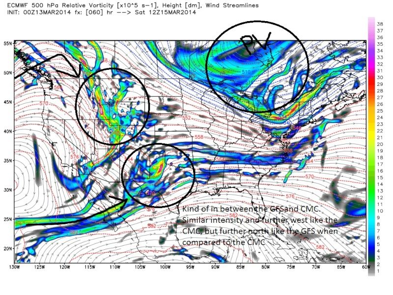
algae888 wrote:every model run from last nights 00z thru todays runs have shown a south push of the PV and the HP to our north. it continues on the 00z gfs and rgem. that is the main reason this storm is south. it's getting squashed by the HP. it's hard to believe that in march we had 2 storm south of us. usually that happens in January. I guess the -epo is to blame. it is strong this year and maybe to strong bringing bitter cold to us. maybe the models are overplaying the cold air I don't know but its just hard to believe its going to snow in Virginia and north Carolina again.
its not the HP, PD2 had a twice as strong high in the same location

NjWeatherGuy- Advanced Forecaster
- Posts : 4100
Reputation : 28
Join date : 2013-01-06
Location : Belle Mead, NJ
Re: March 17th-18th Storm Potential Discussion
![]() by Math23x7 Sat Mar 15, 2014 12:53 am
by Math23x7 Sat Mar 15, 2014 12:53 am
Math23x7- Wx Statistician Guru
- Posts : 2379
Reputation : 68
Join date : 2013-01-08
Re: March 17th-18th Storm Potential Discussion
![]() by Frank_Wx Sat Mar 15, 2014 1:38 am
by Frank_Wx Sat Mar 15, 2014 1:38 am
_________________
_______________________________________________________________________________________________________
CLICK HERE to view NJ Strong Snowstorm Classifications

Frank_Wx- Godzilla Seeker

- Posts : 21305
Reputation : 328
Join date : 2013-01-05
Age : 31
Location : Jersey City, NJ -

Re: March 17th-18th Storm Potential Discussion
![]() by pdubz Sat Mar 15, 2014 4:57 am
by pdubz Sat Mar 15, 2014 4:57 am


pdubz- Pro Enthusiast

- Posts : 539
Reputation : 0
Join date : 2013-09-24
Age : 32
Location : Port Washington,NY (L.I)
Re: March 17th-18th Storm Potential Discussion
![]() by SoulSingMG Sat Mar 15, 2014 5:55 am
by SoulSingMG Sat Mar 15, 2014 5:55 am
pdubz wrote:6z NAM is way south... time to abandon ship
lol. well at least that post made me laugh, despite being HEARTBROKEN again.

SoulSingMG- Senior Enthusiast

- Posts : 2853
Reputation : 74
Join date : 2013-12-11
Location : Long Island City, NY
Re: March 17th-18th Storm Potential Discussion
![]() by pdubz Sat Mar 15, 2014 5:58 am
by pdubz Sat Mar 15, 2014 5:58 am
pdubz- Pro Enthusiast
- Posts : 539
Reputation : 0
Join date : 2013-09-24
Age : 32
Location : Port Washington,NY (L.I)
Re: March 17th-18th Storm Potential Discussion
![]() by SoulSingMG Sat Mar 15, 2014 6:41 am
by SoulSingMG Sat Mar 15, 2014 6:41 am
pdubz wrote:06z GFS is north by 75 miles but im going to act like nothing happened since chances of this reversing are slim to none
Hmmmm. That's a pretty significant bump north actually.
SoulSingMG- Senior Enthusiast
- Posts : 2853
Reputation : 74
Join date : 2013-12-11
Location : Long Island City, NY
Re: March 17th-18th Storm Potential Discussion
![]() by pdubz Sat Mar 15, 2014 6:43 am
by pdubz Sat Mar 15, 2014 6:43 am
SoulSingMG wrote:pdubz wrote:06z GFS is north by 75 miles but im going to act like nothing happened since chances of this reversing are slim to none
Hmmmm. That's a pretty significant bump north actually.
0z GFS

6z GFS

pdubz- Pro Enthusiast
- Posts : 539
Reputation : 0
Join date : 2013-09-24
Age : 32
Location : Port Washington,NY (L.I)
Re: March 17th-18th Storm Potential Discussion
![]() by SoulSingMG Sat Mar 15, 2014 6:48 am
by SoulSingMG Sat Mar 15, 2014 6:48 am
00z run, we were about 75 miles from ANY snow. and about 125 miles form 3-6 inch range.
6z run, we are now in the 1-3" range, and about 50 miles from the 3-6" range in Central Jersey.
That is actually QUITE a difference. Imagine if this becomes a trend for the GFS, what 12z may show...?
SoulSingMG- Senior Enthusiast
- Posts : 2853
Reputation : 74
Join date : 2013-12-11
Location : Long Island City, NY
Re: March 17th-18th Storm Potential Discussion
![]() by essexcountypete Sat Mar 15, 2014 8:03 am
by essexcountypete Sat Mar 15, 2014 8:03 am

essexcountypete- Pro Enthusiast
- Posts : 783
Reputation : 12
Join date : 2013-12-09
Location : Bloomfield, NJ
Re: March 17th-18th Storm Potential Discussion
![]() by jmanley32 Sat Mar 15, 2014 8:15 am
by jmanley32 Sat Mar 15, 2014 8:15 am

jmanley32- Senior Enthusiast
- Posts : 20512
Reputation : 108
Join date : 2013-12-12
Age : 42
Location : Yonkers, NY
Re: March 17th-18th Storm Potential Discussion
![]() by sroc4 Sat Mar 15, 2014 8:29 am
by sroc4 Sat Mar 15, 2014 8:29 am
Euro 00z 3/13/14 :
 " />
" />Euro 00z last night:
 " />
" />They look pretty similar with some slight differences. Pay particular attention to the risge axis and where it is currently centered due west of So. Cal. Now lets see what happens. To do this lets look a little higher in the atmosphere ie: 300mb. Notice there are essentially 3 jet streams here. The Polar jet associated with the PV, the Pacific Jet, and the STJ (sub tropical Jet).
 " />
" />Now lets fast fwd 24hrs at 300mb 12z Sunday. A few things happen here. Now take notice of the ridge axis. Tilted way positive, or SW to NE. But why. Two things happen. There is a strong s/w coming in to the NW west which forces the ridge east, but the stubborn PV forces the pac jet to dig to the SW. As a result the Pac jet phases with the STJ.
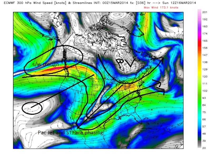 " />
" />Because the axis if the ridge is so pos tilted the resulting trough digs in similarly out ahead of it. We see this as holding back the energy at 500mb. In reality it is the Northern piece of energy in the Pac Jet digging into the base of the trough because of the phase between the Pac jet and STJ. The southern energy is allowed to escape east out ahead of all this because it has no blocking off the east coast to slow down its flow and begins to get sheared out. Lets look at the same time frame, 12z Sunday at 500mb:
 " />
" />And finally 12z Monday. It all starts to break down. The energy gets sheared out because the flow is so progressive out ahead of it due to the pos tilt to the trough.
 " />
" />There is a pos tilted trough, all the energy now in the S is strung out and progressive and a storm track that is well to the south. This overall pattern is now seen on all models. Sorry folks this is going to be another disappointment for most if not all of us for the reasons stated above. There is still a chance S NJ maybe as far north as NYC sees something, but I aint holding my breath on LI. IMO the s/w on the heals of the ridge forces the ridge into the western flank of the PV. The strength of the PV forces the Pac Jet to dig SW. The extreme pos tilt to the ridge axis allows the southern energy to escape out ahead of the northen energy and the northern energy consolidate in the digging the trough, or "holds back" the energy into the SW.
_________________
"In weather and in life, there's no winning and losing; there's only winning and learning."
WINTER 2012/2013 TOTALS 43.65"WINTER 2017/2018 TOTALS 62.85" WINTER 2022/2023 TOTALS 4.9"
WINTER 2013/2014 TOTALS 64.85"WINTER 2018/2019 TOTALS 14.25" WINTER 2023/2024 TOTALS 13.1"
WINTER 2014/2015 TOTALS 71.20"WINTER 2019/2020 TOTALS 6.35"
WINTER 2015/2016 TOTALS 35.00"WINTER 2020/2021 TOTALS 37.75"
WINTER 2016/2017 TOTALS 42.25"WINTER 2021/2022 TOTALS 31.65"

sroc4- Admin
- Posts : 8331
Reputation : 301
Join date : 2013-01-07
Location : Wading River, LI
Re: March 17th-18th Storm Potential Discussion
![]() by pdubz Sat Mar 15, 2014 8:34 am
by pdubz Sat Mar 15, 2014 8:34 am
pdubz- Pro Enthusiast
- Posts : 539
Reputation : 0
Join date : 2013-09-24
Age : 32
Location : Port Washington,NY (L.I)
Re: March 17th-18th Storm Potential Discussion
![]() by CPcantmeasuresnow Sat Mar 15, 2014 8:49 am
by CPcantmeasuresnow Sat Mar 15, 2014 8:49 am
Last edited by CPcantmeasuresnow on Sat Mar 15, 2014 10:29 am; edited 1 time in total

CPcantmeasuresnow- Wx Statistician Guru
- Posts : 7274
Reputation : 230
Join date : 2013-01-07
Age : 103
Location : Eastern Orange County, NY
Re: March 17th-18th Storm Potential Discussion
![]() by skinsfan1177 Sat Mar 15, 2014 9:26 am
by skinsfan1177 Sat Mar 15, 2014 9:26 am

skinsfan1177- Senior Enthusiast
- Posts : 4485
Reputation : 35
Join date : 2013-01-07
Age : 46
Location : Point Pleasant Boro
Re: March 17th-18th Storm Potential Discussion
![]() by Quietace Sat Mar 15, 2014 9:38 am
by Quietace Sat Mar 15, 2014 9:38 am
We will break it with about a 1/4 inch of snow with this storm. Lets hope.skinsfan1177 wrote:Was hoping tp break the 60 inch mark here Ace and I had a great season with snowfall . It was great winter in tracking and everyone on here is great with analysis and keeping people informed and I have learned so much my thing now is to make a decision on getting either storm vista or weather bell and whats the price for them? And is it good for someone who is learning about maps and stuff or is their alternatives?
Skins, i pay Wxbell monthly, and its 19.99. I just charge it to my debit card. I dont know the price of Storm Vista, but i might invest in both next winter, but just keep wxbell over the Summer. Unsure yet. If you really want to see what everyone else is seeing and keep learning and interpreting the models better, and you want or can put the money, in, i guess why not. Pay sites have much more tools than free, and its all in one place. But its really up to you if you want to shell out the money.

Quietace- Meteorologist - Mod

- Posts : 3687
Reputation : 33
Join date : 2013-01-07
Age : 27
Location : Point Pleasant, NJ
Re: March 17th-18th Storm Potential Discussion
![]() by skinsfan1177 Sat Mar 15, 2014 9:51 am
by skinsfan1177 Sat Mar 15, 2014 9:51 am
skinsfan1177- Senior Enthusiast
- Posts : 4485
Reputation : 35
Join date : 2013-01-07
Age : 46
Location : Point Pleasant Boro
Re: March 17th-18th Storm Potential Discussion
![]() by Quietace Sat Mar 15, 2014 10:02 am
by Quietace Sat Mar 15, 2014 10:02 am
Wxbell has a free 7 day trial. Go give it a try then.skinsfan1177 wrote:Thanks Ace appreciate the info yes I feel I need to learn more the only way is to get a paid site and see things for myself. Lets break 60
Quietace- Meteorologist - Mod
- Posts : 3687
Reputation : 33
Join date : 2013-01-07
Age : 27
Location : Point Pleasant, NJ
Re: March 17th-18th Storm Potential Discussion
![]() by amugs Sat Mar 15, 2014 10:32 am
by amugs Sat Mar 15, 2014 10:32 am

_________________
Mugs
AKA:King: Snow Weenie
Self Proclaimed
WINTER 2014-15 : 55.12" +.02 for 6 coatings (avg. 35")
WINTER 2015-16 Total - 29.8" (Avg 35")
WINTER 2016-17 : 39.5" so far

amugs- Advanced Forecaster - Mod

- Posts : 15091
Reputation : 213
Join date : 2013-01-07
Age : 54
Location : Hillsdale,NJ
Re: March 17th-18th Storm Potential Discussion
![]() by Grselig Sat Mar 15, 2014 10:50 am
by Grselig Sat Mar 15, 2014 10:50 am
Greg

Grselig- Senior Enthusiast
- Posts : 1408
Reputation : 140
Join date : 2013-03-04
Age : 54
Location : Wayne NJ
Re: March 17th-18th Storm Potential Discussion
![]() by NjWeatherGuy Sat Mar 15, 2014 11:28 am
by NjWeatherGuy Sat Mar 15, 2014 11:28 am
NjWeatherGuy- Advanced Forecaster
- Posts : 4100
Reputation : 28
Join date : 2013-01-06
Location : Belle Mead, NJ
Re: March 17th-18th Storm Potential Discussion
![]() by aiannone Sat Mar 15, 2014 11:50 am
by aiannone Sat Mar 15, 2014 11:50 am
_________________
-Alex Iannone-

aiannone- Senior Enthusiast - Mod
- Posts : 4813
Reputation : 92
Join date : 2013-01-07
Location : Saint James, LI (Northwest Suffolk Co.)
Re: March 17th-18th Storm Potential Discussion
![]() by aiannone Sat Mar 15, 2014 11:53 am
by aiannone Sat Mar 15, 2014 11:53 am
_________________
-Alex Iannone-
aiannone- Senior Enthusiast - Mod
- Posts : 4813
Reputation : 92
Join date : 2013-01-07
Location : Saint James, LI (Northwest Suffolk Co.)
Re: March 17th-18th Storm Potential Discussion
![]() by NjWeatherGuy Sat Mar 15, 2014 12:36 pm
by NjWeatherGuy Sat Mar 15, 2014 12:36 pm
Mets2695 wrote:12z GFS brings the precip shield further north again due to it depicting a slightly weaker high. Now brings the moderate precip 20mi south of NYC
The .1" line in 6 hours is not moderate, it's over.
NjWeatherGuy- Advanced Forecaster
- Posts : 4100
Reputation : 28
Join date : 2013-01-06
Location : Belle Mead, NJ
Re: March 17th-18th Storm Potential Discussion
![]() by Sanchize06 Sat Mar 15, 2014 2:31 pm
by Sanchize06 Sat Mar 15, 2014 2:31 pm
Sanchize06- Senior Enthusiast
- Posts : 1041
Reputation : 21
Join date : 2013-02-05
Location : Union Beach, NJ
Page 18 of 21 • 1 ... 10 ... 17, 18, 19, 20, 21 ![]()
|
|
|