
 Search
Official Long Range Thread 4.0
Page 39 of 42 •  1 ... 21 ... 38, 39, 40, 41, 42
 ![]()
Re: Official Long Range Thread 4.0
![]() by amugs Thu Dec 11, 2014 1:34 pm
by amugs Thu Dec 11, 2014 1:34 pm
Just in time for back to back snow years on................................MY 45TH BDAY!!!!!
The 17th - last year had a 3" snowfall - could not have asked for a better present - well besides my family taking me to dinner!!
amugs- Advanced Forecaster - Mod

- Posts : 15091
Join date : 2013-01-07
Re: Official Long Range Thread 4.0
![]() by jmanley32 Thu Dec 11, 2014 2:23 pm
by jmanley32 Thu Dec 11, 2014 2:23 pm
jmanley32- Senior Enthusiast

- Posts : 20512
Join date : 2013-12-12
Re: Official Long Range Thread 4.0
![]() by algae888 Thu Dec 11, 2014 2:40 pm
by algae888 Thu Dec 11, 2014 2:40 pm

50/50 lp, hp perfect, closed low over west Virginia and transfer to a coastal and cold. gfs and cmc have low exit off the se coast. still 10 days out but consistent on every model for days now. what are ensemble and means showing?

algae888- Advanced Forecaster

- Posts : 5311
Reputation : 46
Join date : 2013-02-05
Age : 61
Location : mt. vernon, new york
Re: Official Long Range Thread 4.0
![]() by algae888 Thu Dec 11, 2014 2:48 pm
by algae888 Thu Dec 11, 2014 2:48 pm
"The key to a White Christmas is the storm on 12/17. I'll explain to Premium Members tomorrow morning.
New 12Z ECMWF is a lot colder for 12-21 period. Large cold high north of developing coastal low.
Text book set up for 12/21-24 for all of the region."
algae888- Advanced Forecaster
- Posts : 5311
Reputation : 46
Join date : 2013-02-05
Age : 61
Location : mt. vernon, new york
Re: Official Long Range Thread 4.0
![]() by amugs Thu Dec 11, 2014 3:21 pm
by amugs Thu Dec 11, 2014 3:21 pm
jmanley32 wrote:mugs regular GFS does not have much the 17th, I wonder which is right.
That is a good question - bowling ball vort rolling from SW area to the middle of the country and then trying to form a miller b as it cuts and dies over the western PA area and then goes up and into the NAO region to form a nice 50/50 block. Hey i will take a 2-3" event for a possible beast that week xmas that is - GFS has a storm on the 21st then another one xmas
Euro is interested as well
For some reason I can not post storm vista maps - what the h is going on?
_________________
Mugs
AKA:King: Snow Weenie
Self Proclaimed
WINTER 2014-15 : 55.12" +.02 for 6 coatings (avg. 35")
WINTER 2015-16 Total - 29.8" (Avg 35")
WINTER 2016-17 : 39.5" so far

amugs- Advanced Forecaster - Mod
- Posts : 15091
Reputation : 213
Join date : 2013-01-07
Age : 54
Location : Hillsdale,NJ
Re: Official Long Range Thread 4.0
![]() by Frank_Wx Thu Dec 11, 2014 3:44 pm
by Frank_Wx Thu Dec 11, 2014 3:44 pm
_________________
_______________________________________________________________________________________________________
CLICK HERE to view NJ Strong Snowstorm Classifications

Frank_Wx- Godzilla Seeker

- Posts : 21305
Reputation : 328
Join date : 2013-01-05
Age : 31
Location : Jersey City, NJ -


HectorO- Pro Enthusiast

- Posts : 959
Reputation : 27
Join date : 2013-01-11
Re: Official Long Range Thread 4.0
![]() by docstox12 Thu Dec 11, 2014 3:52 pm
by docstox12 Thu Dec 11, 2014 3:52 pm

docstox12- Wx Statistician Guru

- Posts : 8497
Reputation : 222
Join date : 2013-01-07
Age : 73
Location : Monroe NY
Re: Official Long Range Thread 4.0
![]() by sroc4 Thu Dec 11, 2014 4:34 pm
by sroc4 Thu Dec 11, 2014 4:34 pm
17th system to try and set up a 50/50 Low. I mentioned this in my write up a day or two ago. At least I think thats what he is going to talk about.algae888 wrote:steve d on pre xmas storm....
"The key to a White Christmas is the storm on 12/17. I'll explain to Premium Members tomorrow morning.
New 12Z ECMWF is a lot colder for 12-21 period. Large cold high north of developing coastal low.
Text book set up for 12/21-24 for all of the region."
_________________
"In weather and in life, there's no winning and losing; there's only winning and learning."
WINTER 2012/2013 TOTALS 43.65"WINTER 2017/2018 TOTALS 62.85" WINTER 2022/2023 TOTALS 4.9"
WINTER 2013/2014 TOTALS 64.85"WINTER 2018/2019 TOTALS 14.25" WINTER 2023/2024 TOTALS 13.1"
WINTER 2014/2015 TOTALS 71.20"WINTER 2019/2020 TOTALS 6.35"
WINTER 2015/2016 TOTALS 35.00"WINTER 2020/2021 TOTALS 37.75"
WINTER 2016/2017 TOTALS 42.25"WINTER 2021/2022 TOTALS 31.65"

sroc4- Admin
- Posts : 8331
Reputation : 301
Join date : 2013-01-07
Location : Wading River, LI
Re: Official Long Range Thread 4.0
![]() by jmanley32 Thu Dec 11, 2014 6:02 pm
by jmanley32 Thu Dec 11, 2014 6:02 pm

jmanley32- Senior Enthusiast
- Posts : 20512
Reputation : 108
Join date : 2013-12-12
Age : 42
Location : Yonkers, NY
Re: Official Long Range Thread 4.0
![]() by Frank_Wx Thu Dec 11, 2014 6:58 pm
by Frank_Wx Thu Dec 11, 2014 6:58 pm

_________________
_______________________________________________________________________________________________________
CLICK HERE to view NJ Strong Snowstorm Classifications
Frank_Wx- Godzilla Seeker
- Posts : 21305
Reputation : 328
Join date : 2013-01-05
Age : 31
Location : Jersey City, NJ -
Re: Official Long Range Thread 4.0
![]() by CPcantmeasuresnow Thu Dec 11, 2014 7:39 pm
by CPcantmeasuresnow Thu Dec 11, 2014 7:39 pm
NYC received their first trace of snow last winter on November 11 this year only two days off on November 13.
The first one inch snowfall last year was December 10th in CPK this year December 10th again.
The first significant snowfall in CPK last year was December 14th with 5.0 inches, unfortunately I don't see anything right now that will happen within a few days of the 14th, but I can hope.
Last edited by CPcantmeasuresnow on Thu Dec 11, 2014 9:07 pm; edited 1 time in total

CPcantmeasuresnow- Wx Statistician Guru
- Posts : 7274
Reputation : 230
Join date : 2013-01-07
Age : 103
Location : Eastern Orange County, NY
Re: Official Long Range Thread 4.0
![]() by CPcantmeasuresnow Thu Dec 11, 2014 7:46 pm
by CPcantmeasuresnow Thu Dec 11, 2014 7:46 pm
amugs wrote:Middle of the week could be interesting with the system coming out of the lakes interacting with the polar jet. The 12z PGFS even develops a late developing miller B.
Just in time for back to back snow years on................................MY 45TH BDAY!!!!!
The 17th - last year had a 3" snowfall - could not have asked for a better present - well besides my family taking me to dinner!!
Yeah Mugs plus you had a nice lead in to your birthday last year. We had 8 inches of snow on the 14th and NYC had 5 inches on the 14th so I'm guessing it was white where you are going into your birthday, not bad. Great people seem to be born in December and of course Royalty.
CPcantmeasuresnow- Wx Statistician Guru
- Posts : 7274
Reputation : 230
Join date : 2013-01-07
Age : 103
Location : Eastern Orange County, NY
Re: Official Long Range Thread 4.0
![]() by Math23x7 Fri Dec 12, 2014 2:11 am
by Math23x7 Fri Dec 12, 2014 2:11 am
Math23x7- Wx Statistician Guru
- Posts : 2379
Reputation : 68
Join date : 2013-01-08
Re: Official Long Range Thread 4.0
![]() by jmanley32 Fri Dec 12, 2014 8:27 am
by jmanley32 Fri Dec 12, 2014 8:27 am

jmanley32- Senior Enthusiast
- Posts : 20512
Reputation : 108
Join date : 2013-12-12
Age : 42
Location : Yonkers, NY
jmanley32- Senior Enthusiast
- Posts : 20512
Reputation : 108
Join date : 2013-12-12
Age : 42
Location : Yonkers, NY
Re: Official Long Range Thread 4.0
![]() by Quietace Fri Dec 12, 2014 8:36 am
by Quietace Fri Dec 12, 2014 8:36 am
Yup, only 13.5 days out! Hahajmanley32 wrote:Boom!
Good signals on all the models though.

Quietace- Meteorologist - Mod

- Posts : 3687
Reputation : 33
Join date : 2013-01-07
Age : 27
Location : Point Pleasant, NJ

Quietace- Meteorologist - Mod
- Posts : 3687
Reputation : 33
Join date : 2013-01-07
Age : 27
Location : Point Pleasant, NJ
Re: Official Long Range Thread 4.0
![]() by amugs Fri Dec 12, 2014 9:14 am
by amugs Fri Dec 12, 2014 9:14 am

_________________
Mugs
AKA:King: Snow Weenie
Self Proclaimed
WINTER 2014-15 : 55.12" +.02 for 6 coatings (avg. 35")
WINTER 2015-16 Total - 29.8" (Avg 35")
WINTER 2016-17 : 39.5" so far
amugs- Advanced Forecaster - Mod
- Posts : 15091
Reputation : 213
Join date : 2013-01-07
Age : 54
Location : Hillsdale,NJ
Re: Official Long Range Thread 4.0
![]() by Quietace Fri Dec 12, 2014 9:15 am
by Quietace Fri Dec 12, 2014 9:15 am

Quietace- Meteorologist - Mod
- Posts : 3687
Reputation : 33
Join date : 2013-01-07
Age : 27
Location : Point Pleasant, NJ
Re: Official Long Range Thread 4.0
![]() by jmanley32 Fri Dec 12, 2014 9:16 am
by jmanley32 Fri Dec 12, 2014 9:16 am
jmanley32- Senior Enthusiast
- Posts : 20512
Reputation : 108
Join date : 2013-12-12
Age : 42
Location : Yonkers, NY
Re: Official Long Range Thread 4.0
![]() by Quietace Fri Dec 12, 2014 9:19 am
by Quietace Fri Dec 12, 2014 9:19 am
Its early, but we still are not tapping into a truly polar air source. Pre-Christmas event maybe another marginal event but its a long way off to speculate and its just my opinion.jmanley32 wrote:Lookin good on those maps too giggidy, lets just hope its cold enough, which it looks like it will be.
Quietace- Meteorologist - Mod
- Posts : 3687
Reputation : 33
Join date : 2013-01-07
Age : 27
Location : Point Pleasant, NJ
Re: Official Long Range Thread 4.0
![]() by amugs Fri Dec 12, 2014 9:22 am
by amugs Fri Dec 12, 2014 9:22 am
For him to throw that in to me says something - anyone else catch that?
_________________
Mugs
AKA:King: Snow Weenie
Self Proclaimed
WINTER 2014-15 : 55.12" +.02 for 6 coatings (avg. 35")
WINTER 2015-16 Total - 29.8" (Avg 35")
WINTER 2016-17 : 39.5" so far
amugs- Advanced Forecaster - Mod
- Posts : 15091
Reputation : 213
Join date : 2013-01-07
Age : 54
Location : Hillsdale,NJ
Re: Official Long Range Thread 4.0
![]() by jmanley32 Fri Dec 12, 2014 9:23 am
by jmanley32 Fri Dec 12, 2014 9:23 am
jmanley32- Senior Enthusiast
- Posts : 20512
Reputation : 108
Join date : 2013-12-12
Age : 42
Location : Yonkers, NY
Re: Official Long Range Thread 4.0
![]() by Frank_Wx Fri Dec 12, 2014 10:34 am
by Frank_Wx Fri Dec 12, 2014 10:34 am
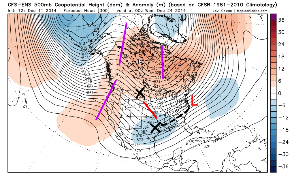
amugs wrote:Ace to add to it NCEP
Can we take a moment to acknowledge how beautiful of an image this is? -NAO, -EPO, -AO. Praise Mary Jospeh Jesus
_________________
_______________________________________________________________________________________________________
CLICK HERE to view NJ Strong Snowstorm Classifications
Frank_Wx- Godzilla Seeker
- Posts : 21305
Reputation : 328
Join date : 2013-01-05
Age : 31
Location : Jersey City, NJ -
Re: Official Long Range Thread 4.0
![]() by sroc4 Fri Dec 12, 2014 10:54 am
by sroc4 Fri Dec 12, 2014 10:54 am
Frank_Wx wrote:amugs wrote:Ace to add to it NCEP
Can we take a moment to acknowledge how beautiful of an image this is? -NAO, -EPO, -AO. Praise Mary Jospeh Jesus
LOL...I thought the same thing. I am in between appts and I just made my employees look at it. They rolled their eyes at me.
_________________
"In weather and in life, there's no winning and losing; there's only winning and learning."
WINTER 2012/2013 TOTALS 43.65"WINTER 2017/2018 TOTALS 62.85" WINTER 2022/2023 TOTALS 4.9"
WINTER 2013/2014 TOTALS 64.85"WINTER 2018/2019 TOTALS 14.25" WINTER 2023/2024 TOTALS 13.1"
WINTER 2014/2015 TOTALS 71.20"WINTER 2019/2020 TOTALS 6.35"
WINTER 2015/2016 TOTALS 35.00"WINTER 2020/2021 TOTALS 37.75"
WINTER 2016/2017 TOTALS 42.25"WINTER 2021/2022 TOTALS 31.65"
sroc4- Admin
- Posts : 8331
Reputation : 301
Join date : 2013-01-07
Location : Wading River, LI
Re: Official Long Range Thread 4.0
![]() by Snow88 Fri Dec 12, 2014 11:01 am
by Snow88 Fri Dec 12, 2014 11:01 am

Snow88- Senior Enthusiast
- Posts : 2193
Reputation : 4
Join date : 2013-01-09
Age : 35
Location : Brooklyn, NY
Page 39 of 42 • 1 ... 21 ... 38, 39, 40, 41, 42 ![]()
|
|
|