
 Search
Update #1: Thursday Sneak Attack?
Page 1 of 4 • 1, 2, 3, 4 ![]()

Update #1: Thursday Sneak Attack?
![]() by aiannone Mon Feb 02, 2015 8:16 pm
by aiannone Mon Feb 02, 2015 8:16 pm
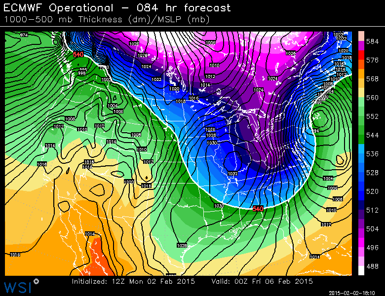
Lets first start with the 12z Euro (says snowstorm) 500mb analysis:

Here we can see the trough really digging as a clipper approaches from the upper plains. This intense digging with the trough due to a strong northern stream allows for this clipper to interact with southern stream energy in the gulf, thus resulting in a phase between the systems and eventually forming a LP off the coast yielding a modest snowstorm for the area.

As the trough moves to the east coast and becomes negatively titled, the LP is able to ride along the trough and thus yield a snowstorm for the area.
So why does the GFS have a "no go" for the area. Well let's take a look:
Here is the 500mb analysis from the 12z GFS. You can clearly see that the northern stream is far weaker, thus the trough is rather progressive and does not interact with the southern stream energy allowing it to scoot off the coast and develop far too late for our area.
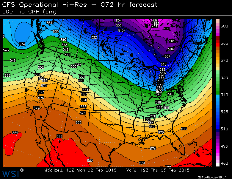
Here you can now see a disorganized elongated, undeveloped area of "lower" pressure well off the coast as a result of the discussed issues.
So what do we take from this? Well the forecast is very uncertain, but I do expect the GFS to trend towards the Euro on this one. This current pattern has suggested strong digging and strong northern streams and I don't see any reason for this to stop. Models tend to do better once storms move out of the area, so tonight's guidance should start some clear trends. My current thoughts would be 60% snowstorm and 40% no snowstorm. Temps and amounts would be worked out much later.
That's all I got for now. Wish I had more time to be more detailed, but that's the info we have now in a nutshell. I'm sure Frank will have a detailed blog out if need be.
Last edited by aiannone on Mon Feb 02, 2015 9:21 pm; edited 1 time in total
_________________
-Alex Iannone-

aiannone- Senior Enthusiast - Mod

- Posts : 4813
Reputation : 92
Join date : 2013-01-07
Location : Saint James, LI (Northwest Suffolk Co.)
Re: Update #1: Thursday Sneak Attack?
![]() by amugs Mon Feb 02, 2015 8:43 pm
by amugs Mon Feb 02, 2015 8:43 pm
_________________
Mugs
AKA:King: Snow Weenie
Self Proclaimed
WINTER 2014-15 : 55.12" +.02 for 6 coatings (avg. 35")
WINTER 2015-16 Total - 29.8" (Avg 35")
WINTER 2016-17 : 39.5" so far

amugs- Advanced Forecaster - Mod
- Posts : 15091
Reputation : 213
Join date : 2013-01-07
Age : 54
Location : Hillsdale,NJ
Re: Update #1: Thursday Sneak Attack?
![]() by devsman Mon Feb 02, 2015 9:07 pm
by devsman Mon Feb 02, 2015 9:07 pm

devsman- Pro Enthusiast

- Posts : 424
Reputation : 4
Join date : 2014-01-01
Age : 48
Location : merrick, ny (south shore of Long Island)
Re: Update #1: Thursday Sneak Attack?
![]() by HeresL Mon Feb 02, 2015 9:17 pm
by HeresL Mon Feb 02, 2015 9:17 pm
Edit: Never mind! The threads were merged and the dates clarified :-) Thanks!
Last edited by HeresL on Mon Feb 02, 2015 9:59 pm; edited 1 time in total
HeresL- Posts : 122
Reputation : 0
Join date : 2013-01-20
Location : West Milford, NJ
Update #1: Thursday Sneak Attack?
![]() by Frank_Wx Mon Feb 02, 2015 9:18 pm
by Frank_Wx Mon Feb 02, 2015 9:18 pm

The arctic front is now off the coast. Temps will plummet into the teens and single digits tonight and cause standing water to rapidly freeze. The Arctic High's diving down into the center of the country are a direct result of the impressive pinched off -EPO over Alaska. We saw some this last winter too.

And it's not just the -EPO helping to configure our upper level pattern. The MJO since the last week of January has been extremely active. When tropical convection gets to or east of the Dateline, this usually signals for a +PNA and an active STJ. The last few storms we have seen have all come with some sort of southern stream energy getting involved in a phase with the northern branch. Clearly the MJO pulse is working in bringing our area storms.
12z EURO

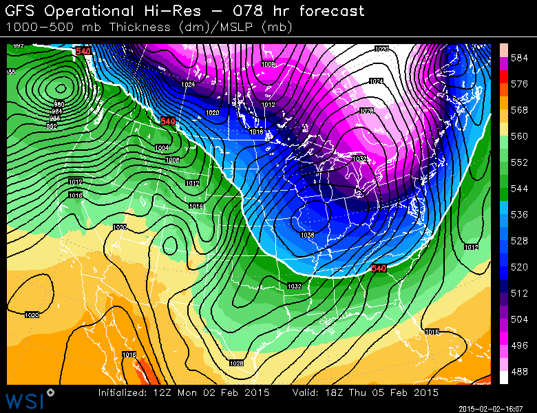
The current state of the PV is in flux. There are multiple Arctic Vortex' over Canada and the Pole that are being ushered down into the U.S. due to the strong -EPO. The large Pacific trough in combination with tropical forcing has consistently kept our PNA in a positive state. These ingredients coupled with some east-based blocking have given us enough for east coast storms. By Thursday morning, the 12z EURO has a nice looking mid-level trough over the eastern U.S. phasing with some southern stream energy.

By Friday morning, this trough has gone negative off our coast and we're once again dealing with another coastal low. That is almost a picture perfect alignment of a Pac. trough, western ridge, and eastern trough. It's a great look on the EURO and would bring another sizable snowfall the our area.

The GFS, of course, differs. Notice how it never digs the northern stream energy and both jets remain un-phased. It still has the -EPO, Pac. trough, and east-based -NAO...so in that regard it is on par with the EURO. It's just a matter of digging the northern stream energy and developing a strong mid-level trough. The GFS has a bias of mis-handling the northern stream energy by usually keeping it too progressive. The EURO has support from its ensembles and the GFS is making incremental trends toward the EURO in each of its runs. So...I definitely feel this potential has to be watched. However, it's certainly possible it amounts to not much like the GFS shows.

The 12z CMC does not look like the EURO, but it still bring a minor snow event to the area. It still digs the northern stream energy much better than the EURO but it's not phasing with southern energy. Instead, it looks more like an arctic front bringing 2-4/3-6 inch type of snows. This is another solution and one that actually makes some sense. The -EPO should allow the northern stream energy to dig much more than the GFS insists. Therefore, I do feel a CMC solution is more likely than that of the GFS.
Either way, I think we will see additional accumulating snowfall this Thursday into Friday. Could be minor, moderate, or heavy. Will depend on how the pattern comes together. But my gut is telling me to side with the EURO then the CMC. Put GFS last even though its been performing pretty well lately.
We shall see
_________________
_______________________________________________________________________________________________________
CLICK HERE to view NJ Strong Snowstorm Classifications

Frank_Wx- Godzilla Seeker

- Posts : 21305
Reputation : 328
Join date : 2013-01-05
Age : 31
Location : Jersey City, NJ -

Re: Update #1: Thursday Sneak Attack?
![]() by Frank_Wx Mon Feb 02, 2015 9:23 pm
by Frank_Wx Mon Feb 02, 2015 9:23 pm
_________________
_______________________________________________________________________________________________________
CLICK HERE to view NJ Strong Snowstorm Classifications
Frank_Wx- Godzilla Seeker
- Posts : 21305
Reputation : 328
Join date : 2013-01-05
Age : 31
Location : Jersey City, NJ -
Re: Update #1: Thursday Sneak Attack?
![]() by aiannone Mon Feb 02, 2015 9:24 pm
by aiannone Mon Feb 02, 2015 9:24 pm
_________________
-Alex Iannone-
aiannone- Senior Enthusiast - Mod
- Posts : 4813
Reputation : 92
Join date : 2013-01-07
Location : Saint James, LI (Northwest Suffolk Co.)
Re: Update #1: Thursday Sneak Attack?
![]() by devsman Mon Feb 02, 2015 9:38 pm
by devsman Mon Feb 02, 2015 9:38 pm
devsman- Pro Enthusiast
- Posts : 424
Reputation : 4
Join date : 2014-01-01
Age : 48
Location : merrick, ny (south shore of Long Island)
Re: Update #1: Thursday Sneak Attack?
![]() by sroc4 Mon Feb 02, 2015 9:52 pm
by sroc4 Mon Feb 02, 2015 9:52 pm
_________________
"In weather and in life, there's no winning and losing; there's only winning and learning."
WINTER 2012/2013 TOTALS 43.65"WINTER 2017/2018 TOTALS 62.85" WINTER 2022/2023 TOTALS 4.9"
WINTER 2013/2014 TOTALS 64.85"WINTER 2018/2019 TOTALS 14.25" WINTER 2023/2024 TOTALS 13.1"
WINTER 2014/2015 TOTALS 71.20"WINTER 2019/2020 TOTALS 6.35"
WINTER 2015/2016 TOTALS 35.00"WINTER 2020/2021 TOTALS 37.75"
WINTER 2016/2017 TOTALS 42.25"WINTER 2021/2022 TOTALS 31.65"

sroc4- Admin
- Posts : 8331
Reputation : 301
Join date : 2013-01-07
Location : Wading River, LI
Re: Update #1: Thursday Sneak Attack?
![]() by elkiehound Mon Feb 02, 2015 10:03 pm
by elkiehound Mon Feb 02, 2015 10:03 pm

elkiehound- Posts : 56
Reputation : 1
Join date : 2013-12-09
Location : Ringoes NJ
Re: Update #1: Thursday Sneak Attack?
![]() by Frank_Wx Mon Feb 02, 2015 10:06 pm
by Frank_Wx Mon Feb 02, 2015 10:06 pm
elkiehound wrote:Mr G says this one could be significant. He did not say Gozilla though
I'm suing the first weatherman that starts naming snowstorms Godzilla. I started this 8 years ago.
_________________
_______________________________________________________________________________________________________
CLICK HERE to view NJ Strong Snowstorm Classifications
Frank_Wx- Godzilla Seeker
- Posts : 21305
Reputation : 328
Join date : 2013-01-05
Age : 31
Location : Jersey City, NJ -
Re: Update #1: Thursday Sneak Attack?
![]() by Dunnzoo Mon Feb 02, 2015 10:15 pm
by Dunnzoo Mon Feb 02, 2015 10:15 pm
Frank_Wx wrote:elkiehound wrote:Mr G says this one could be significant. He did not say Gozilla though
I'm suing the first weatherman that starts naming snowstorms Godzilla. I started this 8 years ago.
Don't worry Frank, they like to use "Epic" and "Historic"
_________________
Janet
Snowfall winter of 2023-2024 17.5"
Snowfall winter of 2022-2023 6.0"
Snowfall winter of 2021-2022 17.6" 1" sleet 2/25/22
Snowfall winter of 2020-2021 51.1"
Snowfall winter of 2019-2020 8.5"
Snowfall winter of 2018-2019 25.1"
Snowfall winter of 2017-2018 51.9"
Snowfall winter of 2016-2017 45.6"
Snowfall winter of 2015-2016 29.5"
Snowfall winter of 2014-2015 50.55"
Snowfall winter of 2013-2014 66.5"

Dunnzoo- Senior Enthusiast - Mod
- Posts : 4882
Reputation : 68
Join date : 2013-01-11
Age : 62
Location : Westwood, NJ
Re: Update #1: Thursday Sneak Attack?
![]() by jmanley32 Mon Feb 02, 2015 10:15 pm
by jmanley32 Mon Feb 02, 2015 10:15 pm

jmanley32- Senior Enthusiast

- Posts : 20512
Reputation : 108
Join date : 2013-12-12
Age : 42
Location : Yonkers, NY
Re: Update #1: Thursday Sneak Attack?
![]() by amugs Mon Feb 02, 2015 10:40 pm
by amugs Mon Feb 02, 2015 10:40 pm
_________________
Mugs
AKA:King: Snow Weenie
Self Proclaimed
WINTER 2014-15 : 55.12" +.02 for 6 coatings (avg. 35")
WINTER 2015-16 Total - 29.8" (Avg 35")
WINTER 2016-17 : 39.5" so far
amugs- Advanced Forecaster - Mod
- Posts : 15091
Reputation : 213
Join date : 2013-01-07
Age : 54
Location : Hillsdale,NJ
Re: Update #1: Thursday Sneak Attack?
![]() by Frank_Wx Mon Feb 02, 2015 10:47 pm
by Frank_Wx Mon Feb 02, 2015 10:47 pm
amugs wrote:Devsman and all in the long range thread I posted the 19z gfs was about 150 miles s & e of the euro shocker it will come a round
They're running the GFS at 19z now too? Silly considering they have an 18z
_________________
_______________________________________________________________________________________________________
CLICK HERE to view NJ Strong Snowstorm Classifications
Frank_Wx- Godzilla Seeker
- Posts : 21305
Reputation : 328
Join date : 2013-01-05
Age : 31
Location : Jersey City, NJ -
Re: Update #1: Thursday Sneak Attack?
![]() by Frank_Wx Mon Feb 02, 2015 10:51 pm
by Frank_Wx Mon Feb 02, 2015 10:51 pm
_________________
_______________________________________________________________________________________________________
CLICK HERE to view NJ Strong Snowstorm Classifications
Frank_Wx- Godzilla Seeker
- Posts : 21305
Reputation : 328
Join date : 2013-01-05
Age : 31
Location : Jersey City, NJ -
Re: Update #1: Thursday Sneak Attack?
![]() by SoulSingMG Mon Feb 02, 2015 10:54 pm
by SoulSingMG Mon Feb 02, 2015 10:54 pm

SoulSingMG- Senior Enthusiast
- Posts : 2853
Reputation : 74
Join date : 2013-12-11
Location : Long Island City, NY
Re: Update #1: Thursday Sneak Attack?
![]() by aiannone Mon Feb 02, 2015 11:00 pm
by aiannone Mon Feb 02, 2015 11:00 pm
sroc4 wrote:Alex Dude!! Great Write up man!! That was like all growed up. And yes I used growed up. It was not autocorrected. In all seriousness that is a great write up. It's going to be fun to watch you get your learn on and see it translate on here. That is unless you get all Cantore on us and become big time and forget about us.
haha thanks Scott! Well I do hope to become the next Cantore, but I will never forget all of you lol. When I'm on TV i'll have to have a rotation schedule with you guys to come cover the storm live with me lol! In the 7 online board I picked up a lot of knowledge from all of you. I owe a bit back lol
_________________
-Alex Iannone-
aiannone- Senior Enthusiast - Mod
- Posts : 4813
Reputation : 92
Join date : 2013-01-07
Location : Saint James, LI (Northwest Suffolk Co.)
Re: Update #1: Thursday Sneak Attack?
![]() by Frank_Wx Mon Feb 02, 2015 11:05 pm
by Frank_Wx Mon Feb 02, 2015 11:05 pm
SoulSingMG wrote:UKIE shows a benchmark storm on Thurs.
Which run?
_________________
_______________________________________________________________________________________________________
CLICK HERE to view NJ Strong Snowstorm Classifications
Frank_Wx- Godzilla Seeker
- Posts : 21305
Reputation : 328
Join date : 2013-01-05
Age : 31
Location : Jersey City, NJ -
Re: Update #1: Thursday Sneak Attack?
![]() by SoulSingMG Tue Feb 03, 2015 1:18 am
by SoulSingMG Tue Feb 03, 2015 1:18 am
SoulSingMG- Senior Enthusiast
- Posts : 2853
Reputation : 74
Join date : 2013-12-11
Location : Long Island City, NY
Re: Update #1: Thursday Sneak Attack?
![]() by algae888 Tue Feb 03, 2015 5:13 am
by algae888 Tue Feb 03, 2015 5:13 am


algae888- Advanced Forecaster

- Posts : 5311
Reputation : 46
Join date : 2013-02-05
Age : 61
Location : mt. vernon, new york

algae888- Advanced Forecaster
- Posts : 5311
Reputation : 46
Join date : 2013-02-05
Age : 61
Location : mt. vernon, new york
Re: Update #1: Thursday Sneak Attack?
![]() by skinsfan1177 Tue Feb 03, 2015 5:37 am
by skinsfan1177 Tue Feb 03, 2015 5:37 am

skinsfan1177- Senior Enthusiast
- Posts : 4485
Reputation : 35
Join date : 2013-01-07
Age : 46
Location : Point Pleasant Boro
Re: Update #1: Thursday Sneak Attack?
![]() by Frank_Wx Tue Feb 03, 2015 7:18 am
by Frank_Wx Tue Feb 03, 2015 7:18 am
_________________
_______________________________________________________________________________________________________
CLICK HERE to view NJ Strong Snowstorm Classifications
Frank_Wx- Godzilla Seeker
- Posts : 21305
Reputation : 328
Join date : 2013-01-05
Age : 31
Location : Jersey City, NJ -
Re: Update #1: Thursday Sneak Attack?
![]() by amugs Tue Feb 03, 2015 7:55 am
by amugs Tue Feb 03, 2015 7:55 am
Frank_Wx wrote:amugs wrote:Devsman and all in the long range thread I posted the 19z gfs was about 150 miles s & e of the euro shocker it will come a round
They're running the GFS at 19z now too? Silly considering they have an 18z
Yes to help save the 18z since it has done so poly they figure wth another run wouldn't hurt. HAHAH bad typing by me once again.
_________________
Mugs
AKA:King: Snow Weenie
Self Proclaimed
WINTER 2014-15 : 55.12" +.02 for 6 coatings (avg. 35")
WINTER 2015-16 Total - 29.8" (Avg 35")
WINTER 2016-17 : 39.5" so far
amugs- Advanced Forecaster - Mod
- Posts : 15091
Reputation : 213
Join date : 2013-01-07
Age : 54
Location : Hillsdale,NJ
Page 1 of 4 • 1, 2, 3, 4 ![]()
|
|
|