
 Search
Polar Blast 2.0 Thursday-Friday, Some Snow Too
Page 3 of 8 •  1, 2, 3, 4, 5, 6, 7, 8
 ![]()
Will CPK get below 0 Thursday night?
Re: Polar Blast 2.0 Thursday-Friday, Some Snow Too
![]() by Frank_Wx Tue Feb 17, 2015 1:16 pm
by Frank_Wx Tue Feb 17, 2015 1:16 pm
Frank_Wx- Godzilla Seeker

- Posts : 21305
Join date : 2013-01-05 -

Re: Polar Blast 2.0 Thursday-Friday, Some Snow Too
![]() by snowday111 Tue Feb 17, 2015 2:14 pm
by snowday111 Tue Feb 17, 2015 2:14 pm
snowday111- Posts : 92
Join date : 2013-01-07
Re: Polar Blast 2.0 Thursday-Friday, Some Snow Too
![]() by Frank_Wx Tue Feb 17, 2015 2:16 pm
by Frank_Wx Tue Feb 17, 2015 2:16 pm
snowday111 wrote:What's the timeframe on this? Thursday morning or Thursday into Friday?
10pm Wednesday through 10am Thursday, then again Thursday night. May come in 2 rounds.
_________________
_______________________________________________________________________________________________________
CLICK HERE to view NJ Strong Snowstorm Classifications

Frank_Wx- Godzilla Seeker
- Posts : 21305
Reputation : 328
Join date : 2013-01-05
Age : 31
Location : Jersey City, NJ -
Re: Polar Blast 2.0 Thursday-Friday, Some Snow Too
![]() by snowday111 Tue Feb 17, 2015 2:17 pm
by snowday111 Tue Feb 17, 2015 2:17 pm
Frank_Wx wrote:snowday111 wrote:What's the timeframe on this? Thursday morning or Thursday into Friday?
10pm Wednesday through 10am Thursday, then again Thursday night. May come in 2 rounds.
Thanks Frank!!
snowday111- Posts : 92
Reputation : 1
Join date : 2013-01-07
Location : Monroe Twp. NJ (Middlesex County)
Re: Polar Blast 2.0 Thursday-Friday, Some Snow Too
![]() by sroc4 Tue Feb 17, 2015 4:06 pm
by sroc4 Tue Feb 17, 2015 4:06 pm
_________________
"In weather and in life, there's no winning and losing; there's only winning and learning."
WINTER 2012/2013 TOTALS 43.65"WINTER 2017/2018 TOTALS 62.85" WINTER 2022/2023 TOTALS 4.9"
WINTER 2013/2014 TOTALS 64.85"WINTER 2018/2019 TOTALS 14.25" WINTER 2023/2024 TOTALS 13.1"
WINTER 2014/2015 TOTALS 71.20"WINTER 2019/2020 TOTALS 6.35"
WINTER 2015/2016 TOTALS 35.00"WINTER 2020/2021 TOTALS 37.75"
WINTER 2016/2017 TOTALS 42.25"WINTER 2021/2022 TOTALS 31.65"

sroc4- Admin
- Posts : 8331
Reputation : 301
Join date : 2013-01-07
Location : Wading River, LI
Re: Polar Blast 2.0 Thursday-Friday, Some Snow Too
![]() by skinsfan1177 Tue Feb 17, 2015 4:53 pm
by skinsfan1177 Tue Feb 17, 2015 4:53 pm

skinsfan1177- Senior Enthusiast

- Posts : 4485
Reputation : 35
Join date : 2013-01-07
Age : 46
Location : Point Pleasant Boro
Re: Polar Blast 2.0 Thursday-Friday, Some Snow Too
![]() by amugs Tue Feb 17, 2015 5:44 pm
by amugs Tue Feb 17, 2015 5:44 pm
skinsfan1177 wrote:Am I hearing coastal areas again have a good chance with this
Possibly Skins - replay of 2014??
_________________
Mugs
AKA:King: Snow Weenie
Self Proclaimed
WINTER 2014-15 : 55.12" +.02 for 6 coatings (avg. 35")
WINTER 2015-16 Total - 29.8" (Avg 35")
WINTER 2016-17 : 39.5" so far

amugs- Advanced Forecaster - Mod

- Posts : 15091
Reputation : 213
Join date : 2013-01-07
Age : 54
Location : Hillsdale,NJ
Re: Polar Blast 2.0 Thursday-Friday, Some Snow Too
![]() by Frank_Wx Tue Feb 17, 2015 6:28 pm
by Frank_Wx Tue Feb 17, 2015 6:28 pm
I'm not sure I've seen any model showing above .10" qpfsroc4 wrote:Frank I think the 1-3" you have scrolling on top is right on, but I think we could see as much as 4"-6" out on the eastern half of LI from late Wed through early Friday. Def an IVT type look to the surface maps. Total QPF amts are anywhere from 0.05"-0.20" depending on the model and the run. With surface temps in the teens and low twenties, and 850's forecasted between -15 and -20 ratios are going to be 30:1 at least; maybe slight higher if the winds remains calm. At 30:1 ratios 0.05-0.20" QPF would be 1.5-6.0" 6" may be ambitious but 4-5" is def attainable IMO.
_________________
_______________________________________________________________________________________________________
CLICK HERE to view NJ Strong Snowstorm Classifications
Frank_Wx- Godzilla Seeker
- Posts : 21305
Reputation : 328
Join date : 2013-01-05
Age : 31
Location : Jersey City, NJ -
Re: Polar Blast 2.0 Thursday-Friday, Some Snow Too
![]() by Frank_Wx Tue Feb 17, 2015 10:47 pm
by Frank_Wx Tue Feb 17, 2015 10:47 pm


_________________
_______________________________________________________________________________________________________
CLICK HERE to view NJ Strong Snowstorm Classifications
Frank_Wx- Godzilla Seeker
- Posts : 21305
Reputation : 328
Join date : 2013-01-05
Age : 31
Location : Jersey City, NJ -
Re: Polar Blast 2.0 Thursday-Friday, Some Snow Too
![]() by Abba701 Wed Feb 18, 2015 12:52 am
by Abba701 Wed Feb 18, 2015 12:52 am
Abba701- Posts : 328
Reputation : 0
Join date : 2013-01-14
Re: Polar Blast 2.0 Thursday-Friday, Some Snow Too
![]() by Abba701 Wed Feb 18, 2015 12:52 am
by Abba701 Wed Feb 18, 2015 12:52 am
Abba701- Posts : 328
Reputation : 0
Join date : 2013-01-14
Re: Polar Blast 2.0 Thursday-Friday, Some Snow Too
![]() by algae888 Wed Feb 18, 2015 4:57 am
by algae888 Wed Feb 18, 2015 4:57 am
LINE OF SNOW SHOWERS PUSHING ACROSS THE AREA AHEAD OF THE ARCTIC
FRONT TONIGHT. MEAN OF SREF/NAM/GFS SNOW IN BUFKIT IS GENERALLY
RIGHT AROUND TO JUST OVER AN INCH. HOWEVER SOME SREF MEMBERS SHOW
3-5 INCHES AT VARIOUS LOCATIONS OVER THE TRI-STATE - MAINLY E.
GIVEN BAND MIGHT WEAKEN GOING OVER THE POCONOS AND THEN REFORM
OVER THE W PART OF THE AREA - HIGHER AMOUNTS EAST DO MAKE SOME
SENSE.
FOR NOW FORECASTING AROUND AN INCH FROM THESE SNOW SHOWERS
TONIGHT...HOWEVER CANNOT RULE OUT THE POTENTIAL FOR ISOLD-SCT 3-5
INCH BURSTS OF SNOW DEPENDING ON EXACT INTENSITY OF LINE. GIVEN
UNCERTAINTY AND TIMING EXPECTED AFTER RUSH HOUR WILL NOT ADDRESS
THREAT WITH A WINTER WEATHER ADVISORY AT THIS TIME. FOR NOW APPEARS
BEST TO HANDLE WITH AN SPS. WILL ALSO MENTION IN HWO.
USED A BLEND OF ECS/MAV/MET GUIDANCE AND NAM 2-METER TEMPERATURES
FOR LOWS TONIGHT...WITH VALUES AROUND 10 DEGREES BELOW NORMAL.
NEXT WRINKLE IN FORECAST IS POTENTIAL FOR SNOW ON THURSDAY IN
RESPONSE TO COASTAL LOW DEVELOPING OFF CAPE COD AND PASSING OF
UPPER TROUGH AXIS. GIVEN AMOUNT OF COLD AIR PUSHING IN ALOFT -
WILL HAVE AT LEAST CONDITIONALLY UNSTABLE LAPSE RATES UP THROUGH
AROUND 700 HPA THURSDAY AFTERNOON SO HAVE KEPT THINGS SNOW SHOWERS
FOR NOW. THERE IS THE POTENTIAL FOR AN ADDITIONAL 1-2 INCHES OF
SNOW ON THURSDAY MAINLY FROM LONG ISLAND AND CT ON TOP OF WHATEVER
IS RECEIVED TONIGHT.

algae888- Advanced Forecaster

- Posts : 5311
Reputation : 46
Join date : 2013-02-05
Age : 61
Location : mt. vernon, new york
Re: Polar Blast 2.0 Thursday-Friday, Some Snow Too
![]() by sroc4 Wed Feb 18, 2015 6:24 am
by sroc4 Wed Feb 18, 2015 6:24 am
Frank_Wx wrote:I'm not sure I've seen any model showing above .10" qpfsroc4 wrote:Frank I think the 1-3" you have scrolling on top is right on, but I think we could see as much as 4"-6" out on the eastern half of LI from late Wed through early Friday. Def an IVT type look to the surface maps. Total QPF amts are anywhere from 0.05"-0.20" depending on the model and the run. With surface temps in the teens and low twenties, and 850's forecasted between -15 and -20 ratios are going to be 30:1 at least; maybe slight higher if the winds remains calm. At 30:1 ratios 0.05-0.20" QPF would be 1.5-6.0" 6" may be ambitious but 4-5" is def attainable IMO.
You are absolutely right about QPF totals, but VV over LI look pretty good at times esp on Thursday as the IVT axis rotates through, and Im not sure global models will pick up on those finer details, and the S/R models are not quite in their wheel house yet. Again 1-3" total Wed night through early Friday is more realistic, however, eastern half of LI still may see isolated higher amts if a few short lived bursts, ie: 1-3hrs worth, of heavy high ratio snow bursts occur. Im going out on a limb and say 3-6" isolated amts from say Sagtikos/Sunken Meadow Pkway on east. Prob wont happen, but as Al pointed out in the NWS discussion above the potential exists.
_________________
"In weather and in life, there's no winning and losing; there's only winning and learning."
WINTER 2012/2013 TOTALS 43.65"WINTER 2017/2018 TOTALS 62.85" WINTER 2022/2023 TOTALS 4.9"
WINTER 2013/2014 TOTALS 64.85"WINTER 2018/2019 TOTALS 14.25" WINTER 2023/2024 TOTALS 13.1"
WINTER 2014/2015 TOTALS 71.20"WINTER 2019/2020 TOTALS 6.35"
WINTER 2015/2016 TOTALS 35.00"WINTER 2020/2021 TOTALS 37.75"
WINTER 2016/2017 TOTALS 42.25"WINTER 2021/2022 TOTALS 31.65"
sroc4- Admin
- Posts : 8331
Reputation : 301
Join date : 2013-01-07
Location : Wading River, LI
Re: Polar Blast 2.0 Thursday-Friday, Some Snow Too
![]() by Frank_Wx Wed Feb 18, 2015 10:46 am
by Frank_Wx Wed Feb 18, 2015 10:46 am
_________________
_______________________________________________________________________________________________________
CLICK HERE to view NJ Strong Snowstorm Classifications
Frank_Wx- Godzilla Seeker
- Posts : 21305
Reputation : 328
Join date : 2013-01-05
Age : 31
Location : Jersey City, NJ -
Re: Polar Blast 2.0 Thursday-Friday, Some Snow Too
![]() by NjWeatherGuy Wed Feb 18, 2015 11:46 am
by NjWeatherGuy Wed Feb 18, 2015 11:46 am

NjWeatherGuy- Advanced Forecaster
- Posts : 4100
Reputation : 28
Join date : 2013-01-06
Location : Belle Mead, NJ
Re: Polar Blast 2.0 Thursday-Friday, Some Snow Too
![]() by jmanley32 Wed Feb 18, 2015 12:09 pm
by jmanley32 Wed Feb 18, 2015 12:09 pm

jmanley32- Senior Enthusiast
- Posts : 20512
Reputation : 108
Join date : 2013-12-12
Age : 42
Location : Yonkers, NY
Re: Polar Blast 2.0 Thursday-Friday, Some Snow Too
![]() by snow247 Wed Feb 18, 2015 1:10 pm
by snow247 Wed Feb 18, 2015 1:10 pm

snow247- Pro Enthusiast

- Posts : 2417
Reputation : 0
Join date : 2014-08-27
Location : Mount Ivy, NY - Elevation 545'
Re: Polar Blast 2.0 Thursday-Friday, Some Snow Too
![]() by Frank_Wx Wed Feb 18, 2015 2:48 pm
by Frank_Wx Wed Feb 18, 2015 2:48 pm
snow247 wrote:Possible school delays tomorrow?
Doubtful. Unless the IVT sets up over your area and does not move. Can't rely on that though
_________________
_______________________________________________________________________________________________________
CLICK HERE to view NJ Strong Snowstorm Classifications
Frank_Wx- Godzilla Seeker
- Posts : 21305
Reputation : 328
Join date : 2013-01-05
Age : 31
Location : Jersey City, NJ -
Re: Polar Blast 2.0 Thursday-Friday, Some Snow Too
![]() by cooladi Wed Feb 18, 2015 3:21 pm
by cooladi Wed Feb 18, 2015 3:21 pm
cooladi- Pro Enthusiast
- Posts : 185
Reputation : 2
Join date : 2013-01-08
Location : East Rockaway, NY 11518
Re: Polar Blast 2.0 Thursday-Friday, Some Snow Too
![]() by Frank_Wx Wed Feb 18, 2015 3:28 pm
by Frank_Wx Wed Feb 18, 2015 3:28 pm
Friday night:

Saturday night:

It's going to be close
_________________
_______________________________________________________________________________________________________
CLICK HERE to view NJ Strong Snowstorm Classifications
Frank_Wx- Godzilla Seeker
- Posts : 21305
Reputation : 328
Join date : 2013-01-05
Age : 31
Location : Jersey City, NJ -
Re: Polar Blast 2.0 Thursday-Friday, Some Snow Too
![]() by algae888 Wed Feb 18, 2015 3:35 pm
by algae888 Wed Feb 18, 2015 3:35 pm


algae888- Advanced Forecaster
- Posts : 5311
Reputation : 46
Join date : 2013-02-05
Age : 61
Location : mt. vernon, new york
Re: Polar Blast 2.0 Thursday-Friday, Some Snow Too
![]() by aiannone Wed Feb 18, 2015 3:53 pm
by aiannone Wed Feb 18, 2015 3:53 pm
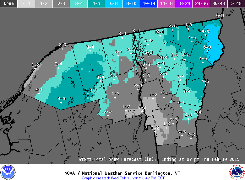
THE NATIONAL WEATHER SERVICE IN BURLINGTON HAS EXTENDED THE
WINTER WEATHER ADVISORY FOR CALEDONIA...ESSEX AND ORLEANS
COUNTIES IN NORTHEASTERN VERMONT...FROM 7 PM THIS EVENING TO 7 PM
EST THURSDAY.
* LOCATIONS...NORTHEASTERN VERMONT.
* HAZARD TYPES...SNOW.
* ACCUMULATIONS...4 TO 6 INCHES OF SNOW.
* MAXIMUM SNOWFALL RATE...UP TO 1 INCH PER HOUR...MAINLY EARLY
THURSDAY MORNING.
* TIMING...LIGHT SNOW WILL OVERSPREAD THE ADVISORY AREA THIS
EVENING AND BECOME STEADIER OVERNIGHT BEFORE ABATING IN
INTENSITY ON THURSDAY.
_________________
-Alex Iannone-

aiannone- Senior Enthusiast - Mod
- Posts : 4813
Reputation : 92
Join date : 2013-01-07
Location : Saint James, LI (Northwest Suffolk Co.)
Re: Polar Blast 2.0 Thursday-Friday, Some Snow Too
![]() by SoulSingMG Wed Feb 18, 2015 4:07 pm
by SoulSingMG Wed Feb 18, 2015 4:07 pm
That inverted trough just pops snow right out of thin air, radar just blew up there. Won't be surprised if someone in that neck of the woods gets 12+ out of this.

SoulSingMG- Senior Enthusiast
- Posts : 2853
Reputation : 74
Join date : 2013-12-11
Location : Long Island City, NY
Re: Polar Blast 2.0 Thursday-Friday, Some Snow Too
![]() by aiannone Wed Feb 18, 2015 4:15 pm
by aiannone Wed Feb 18, 2015 4:15 pm
NWS Grey, Maine

_________________
-Alex Iannone-
aiannone- Senior Enthusiast - Mod
- Posts : 4813
Reputation : 92
Join date : 2013-01-07
Location : Saint James, LI (Northwest Suffolk Co.)
Re: Polar Blast 2.0 Thursday-Friday, Some Snow Too
![]() by Frank_Wx Wed Feb 18, 2015 4:16 pm
by Frank_Wx Wed Feb 18, 2015 4:16 pm
SoulSingMG wrote:Unreal, checkout the radar in Southwestern Maine (Biddeford area)...
That inverted trough just pops snow right out of thin air, radar just blew up there. Won't be surprised if someone in that neck of the woods gets 12+ out of this.

_________________
_______________________________________________________________________________________________________
CLICK HERE to view NJ Strong Snowstorm Classifications
Frank_Wx- Godzilla Seeker
- Posts : 21305
Reputation : 328
Join date : 2013-01-05
Age : 31
Location : Jersey City, NJ -
Re: Polar Blast 2.0 Thursday-Friday, Some Snow Too
![]() by Frank_Wx Wed Feb 18, 2015 4:19 pm
by Frank_Wx Wed Feb 18, 2015 4:19 pm
_________________
_______________________________________________________________________________________________________
CLICK HERE to view NJ Strong Snowstorm Classifications
Frank_Wx- Godzilla Seeker
- Posts : 21305
Reputation : 328
Join date : 2013-01-05
Age : 31
Location : Jersey City, NJ -
Re: Polar Blast 2.0 Thursday-Friday, Some Snow Too
![]() by snow247 Wed Feb 18, 2015 4:54 pm
by snow247 Wed Feb 18, 2015 4:54 pm

snow247- Pro Enthusiast
- Posts : 2417
Reputation : 0
Join date : 2014-08-27
Location : Mount Ivy, NY - Elevation 545'
Page 3 of 8 • 1, 2, 3, 4, 5, 6, 7, 8 ![]()
|
|
|