
 Search
Long Range Thread 9.0
Page 2 of 40 •  1, 2, 3 ... 21 ... 40
 ![]()
Re: Long Range Thread 9.0
![]() by amugs Sat Jan 02, 2016 11:42 pm
by amugs Sat Jan 02, 2016 11:42 pm
amugs- Advanced Forecaster - Mod

- Posts : 15091
Join date : 2013-01-07
Re: Long Range Thread 9.0
![]() by Snow88 Sun Jan 03, 2016 12:24 am
by Snow88 Sun Jan 03, 2016 12:24 am
Snow88- Senior Enthusiast

- Posts : 2193
Join date : 2013-01-09
Re: Long Range Thread 9.0
![]() by Snow88 Sun Jan 03, 2016 12:30 am
by Snow88 Sun Jan 03, 2016 12:30 am

Snow88- Senior Enthusiast
- Posts : 2193
Reputation : 4
Join date : 2013-01-09
Age : 35
Location : Brooklyn, NY
Re: Long Range Thread 9.0
![]() by Snow88 Sun Jan 03, 2016 1:37 am
by Snow88 Sun Jan 03, 2016 1:37 am
Snow88- Senior Enthusiast
- Posts : 2193
Reputation : 4
Join date : 2013-01-09
Age : 35
Location : Brooklyn, NY
Re: Long Range Thread 9.0
![]() by Snow88 Sun Jan 03, 2016 1:46 am
by Snow88 Sun Jan 03, 2016 1:46 am
Snow88- Senior Enthusiast
- Posts : 2193
Reputation : 4
Join date : 2013-01-09
Age : 35
Location : Brooklyn, NY
Re: Long Range Thread 9.0
![]() by HectorO Sun Jan 03, 2016 2:15 am
by HectorO Sun Jan 03, 2016 2:15 am

HectorO- Pro Enthusiast

- Posts : 959
Reputation : 27
Join date : 2013-01-11
Re: Long Range Thread 9.0
![]() by skinsfan1177 Sun Jan 03, 2016 5:51 am
by skinsfan1177 Sun Jan 03, 2016 5:51 am

skinsfan1177- Senior Enthusiast
- Posts : 4485
Reputation : 35
Join date : 2013-01-07
Age : 46
Location : Point Pleasant Boro
Re: Long Range Thread 9.0
![]() by NjWeatherGuy Sun Jan 03, 2016 6:57 am
by NjWeatherGuy Sun Jan 03, 2016 6:57 am
http://mag.ncep.noaa.gov/Image.php?fhr=252&image=data%2Fgfs%2F06%2Fgfs_namer_252_850_temp_mslp_precip.gif&model=gfs&area=namer¶m=850_temp_mslp_precip&group=Model+Guidance&preselected_formatted_cycle_date=20160103+06+UTC&imageSize=M&ps=model

NjWeatherGuy- Advanced Forecaster

- Posts : 4100
Reputation : 28
Join date : 2013-01-06
Location : Belle Mead, NJ
Re: Long Range Thread 9.0
![]() by sroc4 Sun Jan 03, 2016 8:13 am
by sroc4 Sun Jan 03, 2016 8:13 am
All images are depicting the time frame of Jan 8th 12z:
Starting at 500mb:
Jan 1st
 " />
" />Jan 2nd
 " />
" />Jan 3rd
 " />
" />Now the surface:
Jan 1st
 " />
" />Jan 2nd
 " />
" />Jan 3rd
 " />
" />We will have to see where this goes. I am not looking past it entirely just yet, but as of this morning the first system is losing steam in my eyes; although, it never was a strong threat to begin with. I am not going to comment on the second system yet because this first one sets the stage to the second. Happy Sunday!!
_________________
"In weather and in life, there's no winning and losing; there's only winning and learning."
WINTER 2012/2013 TOTALS 43.65"WINTER 2017/2018 TOTALS 62.85" WINTER 2022/2023 TOTALS 4.9"
WINTER 2013/2014 TOTALS 64.85"WINTER 2018/2019 TOTALS 14.25" WINTER 2023/2024 TOTALS 13.1"
WINTER 2014/2015 TOTALS 71.20"WINTER 2019/2020 TOTALS 6.35"
WINTER 2015/2016 TOTALS 35.00"WINTER 2020/2021 TOTALS 37.75"
WINTER 2016/2017 TOTALS 42.25"WINTER 2021/2022 TOTALS 31.65"

sroc4- Admin

- Posts : 8331
Reputation : 301
Join date : 2013-01-07
Location : Wading River, LI
Re: Long Range Thread 9.0
![]() by frank 638 Sun Jan 03, 2016 9:21 am
by frank 638 Sun Jan 03, 2016 9:21 am
frank 638- Senior Enthusiast
- Posts : 2823
Reputation : 37
Join date : 2016-01-01
Age : 40
Location : bronx ny
Re: Long Range Thread 9.0
![]() by CPcantmeasuresnow Sun Jan 03, 2016 9:21 am
by CPcantmeasuresnow Sun Jan 03, 2016 9:21 am
Oh well at least temperatures are now near normal.

CPcantmeasuresnow- Wx Statistician Guru

- Posts : 7274
Reputation : 230
Join date : 2013-01-07
Age : 103
Location : Eastern Orange County, NY
Re: Long Range Thread 9.0
![]() by weatherwatchermom Sun Jan 03, 2016 9:24 am
by weatherwatchermom Sun Jan 03, 2016 9:24 am

weatherwatchermom- Senior Enthusiast
- Posts : 3729
Reputation : 77
Join date : 2014-11-25
Age : 60
Location : Hazlet Township, NJ
Re: Long Range Thread 9.0
![]() by weatherwatchermom Sun Jan 03, 2016 9:32 am
by weatherwatchermom Sun Jan 03, 2016 9:32 am
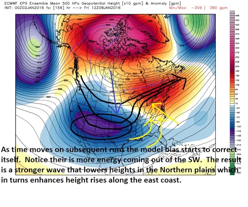
Trying to learn so I have a quest..the vort is the circle that is closed at 540 right...sorry if I asked in wrong place...txamugs wrote:Vort closes off

weatherwatchermom- Senior Enthusiast
- Posts : 3729
Reputation : 77
Join date : 2014-11-25
Age : 60
Location : Hazlet Township, NJ
Re: Long Range Thread 9.0
![]() by Frank_Wx Sun Jan 03, 2016 9:38 am
by Frank_Wx Sun Jan 03, 2016 9:38 am
weatherwatchermom wrote:Trying to learn so I have a quest..the vort is the circle that is closed at 540 right...sorry if I asked in wrong place...txamugs wrote:Vort closes off
That is correct. When a 500mb vort closes off it's less likely to follow the jet stream out to sea. It's also indicative of a very strong piece of upper energy, so any phase would result in a pretty big storm. Lastly, there could already be a surface low reflection under a closed off 500mb vort.
_________________
_______________________________________________________________________________________________________
CLICK HERE to view NJ Strong Snowstorm Classifications

Frank_Wx- Godzilla Seeker
- Posts : 21305
Reputation : 328
Join date : 2013-01-05
Age : 31
Location : Jersey City, NJ -

Re: Long Range Thread 9.0
![]() by Frank_Wx Sun Jan 03, 2016 9:41 am
by Frank_Wx Sun Jan 03, 2016 9:41 am
A lot to like about the setup for Storm #2. Even the EURO jumped on board last night.
_________________
_______________________________________________________________________________________________________
CLICK HERE to view NJ Strong Snowstorm Classifications
Frank_Wx- Godzilla Seeker
- Posts : 21305
Reputation : 328
Join date : 2013-01-05
Age : 31
Location : Jersey City, NJ -
Re: Long Range Thread 9.0
![]() by Guest Sun Jan 03, 2016 10:23 am
by Guest Sun Jan 03, 2016 10:23 am
Guest- Guest
Re: Long Range Thread 9.0
![]() by Frank_Wx Sun Jan 03, 2016 10:31 am
by Frank_Wx Sun Jan 03, 2016 10:31 am
syosnow94 wrote:I'm re-posting this from the banter thread in case no one reads it there because I'm pretty sure that a lot of fellow weenies feel like I do..................If our pattern change is going to deliver storms that bring us rain and upper 30's like storm number 1 does, than I'd like to go back to December. At least I can golf and fish. I hope Frank and the crawl on the homepage are right because guys like me, and CP have reached our patience limit.
People are getting away from my original thoughts and turning them into what I perceive as reality. My Mo Mo from last week ended by giving you my timeline to the pattern change. Here it is again:
Week 4 December: Old pattern regime continues. Expect to continue seeing above normal temperatures.
Week 1 January: Pattern transition begins due to the pulsing MJO into phase 7 / progression of the Scandinavian Ridge. Periods of below normal temperature days mixed with a day or two of slightly above normal.
Week 2 January: The strongest wave of energy transfer from the Troposphere to the Stratosphere should occur and an upper Strat PV displacement is probable. A blocking pattern over the Arctic in conjunction with an active STJ could result in our first significant east coast winter storm event of the season.
Week 3 January: Another period of relaxation is possible depending on whether or not the blocking pattern has staying power. That said, the development of the Aleutian trough in week 2 should keep higher heights confined to western NA. So we could see a pattern that looks closer to week 1 of January. At this point, the Stratospheric PV should be displaced but Tropospheric changes will not arise until later on.
Week 4 January: Full scale pattern change should come to fruition this week. If memory serves me correctly, last winter we saw our pattern change around this time frame as well. By this point, I think we'll see a sustained -AO thank to PV displacement along with a +PNA. Depending on exactly where the Strat PV tracks to will dictate the evolution of the NAO. We're already seeing the QBO trend toward neutral levels. If this trend continues and the blocking pattern the 2nd week of January comes to fruition, it's possible the NAO goes negative much sooner than expected. For now, I think it will go negative around week 4 of January or week 1 of February.
If you notice, I said PATTERN TRANSITION takes place week 1 of January. Which is true, we'll see below normal temps in the beginning of the week with a return to seasonable by the weekend. I even mention there will be a day or two of above normal, which is likely around the time Storm #1 happens between the 8th-9th.
For week #2, I talk about the blocking pattern and how that could deliver our first widespread snow event of the season, hence the scroll. We're seeing Tropical Forcing driven Pacific blocking that will bring Arcric air into the CONUS. I'll talk more about this in tomorrow's Mo Mo.
A true pattern change to sustained cold / snowy weather is not likely until week 4 of January. I remain confident in this prediction.
_________________
_______________________________________________________________________________________________________
CLICK HERE to view NJ Strong Snowstorm Classifications
Frank_Wx- Godzilla Seeker
- Posts : 21305
Reputation : 328
Join date : 2013-01-05
Age : 31
Location : Jersey City, NJ -
Re: Long Range Thread 9.0
![]() by docstox12 Sun Jan 03, 2016 11:16 am
by docstox12 Sun Jan 03, 2016 11:16 am
Steady as she goes according to our Leader Frank.

docstox12- Wx Statistician Guru
- Posts : 8497
Reputation : 222
Join date : 2013-01-07
Age : 73
Location : Monroe NY
Re: Long Range Thread 9.0
![]() by hyde345 Sun Jan 03, 2016 11:49 am
by hyde345 Sun Jan 03, 2016 11:49 am

hyde345- Pro Enthusiast
- Posts : 1082
Reputation : 48
Join date : 2013-01-08
Location : Hyde Park, NY
Re: Long Range Thread 9.0
![]() by weatherwatchermom Sun Jan 03, 2016 12:05 pm
by weatherwatchermom Sun Jan 03, 2016 12:05 pm
Frank_Wx wrote:weatherwatchermom wrote:Trying to learn so I have a quest..the vort is the circle that is closed at 540 right...sorry if I asked in wrong place...txamugs wrote:Vort closes off
That is correct. When a 500mb vort closes off it's less likely to follow the jet stream out to sea. It's also indicative of a very strong piece of upper energy, so any phase would result in a pretty big storm. Lastly, there could already be a surface low reflection under a closed off 500mb vort.
Thank you Frank!!
weatherwatchermom- Senior Enthusiast
- Posts : 3729
Reputation : 77
Join date : 2014-11-25
Age : 60
Location : Hazlet Township, NJ
Re: Long Range Thread 9.0
![]() by sroc4 Sun Jan 03, 2016 3:14 pm
by sroc4 Sun Jan 03, 2016 3:14 pm
weatherwatchermom wrote:Wow what a great write up scott, you are so clear in your explanation...it really helped me(just a snow lover with no background in weather forecasting)to understand!! Thank you!!
Your so welcome.
_________________
"In weather and in life, there's no winning and losing; there's only winning and learning."
WINTER 2012/2013 TOTALS 43.65"WINTER 2017/2018 TOTALS 62.85" WINTER 2022/2023 TOTALS 4.9"
WINTER 2013/2014 TOTALS 64.85"WINTER 2018/2019 TOTALS 14.25" WINTER 2023/2024 TOTALS 13.1"
WINTER 2014/2015 TOTALS 71.20"WINTER 2019/2020 TOTALS 6.35"
WINTER 2015/2016 TOTALS 35.00"WINTER 2020/2021 TOTALS 37.75"
WINTER 2016/2017 TOTALS 42.25"WINTER 2021/2022 TOTALS 31.65"
sroc4- Admin
- Posts : 8331
Reputation : 301
Join date : 2013-01-07
Location : Wading River, LI
Re: Long Range Thread 9.0
![]() by Frank_Wx Sun Jan 03, 2016 3:14 pm
by Frank_Wx Sun Jan 03, 2016 3:14 pm
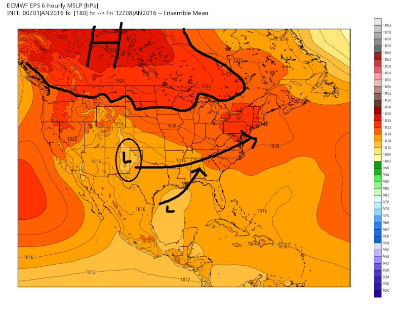
How the southern and northern vorts interact, if at all, will depend on how quickly storm 1 can push north-northeast into Canada. Also, and probably most importantly, the northern stream energy needs to dig into the CONUS instead of cutting off (or phasing) in western Canada. A phase with polar or PV energy will leave the southern vort out to dry and would likely result in a storm track to our west since the SE ridge will be able to amplify again.

_________________
_______________________________________________________________________________________________________
CLICK HERE to view NJ Strong Snowstorm Classifications
Frank_Wx- Godzilla Seeker
- Posts : 21305
Reputation : 328
Join date : 2013-01-05
Age : 31
Location : Jersey City, NJ -
Re: Long Range Thread 9.0
![]() by sroc4 Sun Jan 03, 2016 3:43 pm
by sroc4 Sun Jan 03, 2016 3:43 pm
_________________
"In weather and in life, there's no winning and losing; there's only winning and learning."
WINTER 2012/2013 TOTALS 43.65"WINTER 2017/2018 TOTALS 62.85" WINTER 2022/2023 TOTALS 4.9"
WINTER 2013/2014 TOTALS 64.85"WINTER 2018/2019 TOTALS 14.25" WINTER 2023/2024 TOTALS 13.1"
WINTER 2014/2015 TOTALS 71.20"WINTER 2019/2020 TOTALS 6.35"
WINTER 2015/2016 TOTALS 35.00"WINTER 2020/2021 TOTALS 37.75"
WINTER 2016/2017 TOTALS 42.25"WINTER 2021/2022 TOTALS 31.65"
sroc4- Admin
- Posts : 8331
Reputation : 301
Join date : 2013-01-07
Location : Wading River, LI
Re: Long Range Thread 9.0
![]() by Frank_Wx Sun Jan 03, 2016 3:48 pm
by Frank_Wx Sun Jan 03, 2016 3:48 pm
sroc4 wrote:Euro ensembles look amazing for the second system. And look amazing for cold thereafter.
The control run shows a Godzilla. Hopefully as the week goes on models trend in this direction.

_________________
_______________________________________________________________________________________________________
CLICK HERE to view NJ Strong Snowstorm Classifications
Frank_Wx- Godzilla Seeker
- Posts : 21305
Reputation : 328
Join date : 2013-01-05
Age : 31
Location : Jersey City, NJ -
Re: Long Range Thread 9.0
![]() by sroc4 Sun Jan 03, 2016 3:51 pm
by sroc4 Sun Jan 03, 2016 3:51 pm
Frank_Wx wrote:sroc4 wrote:Euro ensembles look amazing for the second system. And look amazing for cold thereafter.
The control run shows a Godzilla. Hopefully as the week goes on models trend in this direction.
Weather porn.
_________________
"In weather and in life, there's no winning and losing; there's only winning and learning."
WINTER 2012/2013 TOTALS 43.65"WINTER 2017/2018 TOTALS 62.85" WINTER 2022/2023 TOTALS 4.9"
WINTER 2013/2014 TOTALS 64.85"WINTER 2018/2019 TOTALS 14.25" WINTER 2023/2024 TOTALS 13.1"
WINTER 2014/2015 TOTALS 71.20"WINTER 2019/2020 TOTALS 6.35"
WINTER 2015/2016 TOTALS 35.00"WINTER 2020/2021 TOTALS 37.75"
WINTER 2016/2017 TOTALS 42.25"WINTER 2021/2022 TOTALS 31.65"
sroc4- Admin
- Posts : 8331
Reputation : 301
Join date : 2013-01-07
Location : Wading River, LI
Re: Long Range Thread 9.0
![]() by Frank_Wx Sun Jan 03, 2016 4:00 pm
by Frank_Wx Sun Jan 03, 2016 4:00 pm
sroc4 wrote:Euro ensembles look amazing for the second system. And look amazing for cold thereafter.
Ensemble means have such a nice look. Holy cow. Cross Polar Flow city!!

_________________
_______________________________________________________________________________________________________
CLICK HERE to view NJ Strong Snowstorm Classifications
Frank_Wx- Godzilla Seeker
- Posts : 21305
Reputation : 328
Join date : 2013-01-05
Age : 31
Location : Jersey City, NJ -
Re: Long Range Thread 9.0
![]() by jmanley32 Sun Jan 03, 2016 4:01 pm
by jmanley32 Sun Jan 03, 2016 4:01 pm
sroc4 wrote:Frank_Wx wrote:sroc4 wrote:Euro ensembles look amazing for the second system. And look amazing for cold thereafter.
The control run shows a Godzilla. Hopefully as the week goes on models trend in this direction. Omg wow
Weather porn.

jmanley32- Senior Enthusiast
- Posts : 20512
Reputation : 108
Join date : 2013-12-12
Age : 42
Location : Yonkers, NY
Page 2 of 40 • 1, 2, 3 ... 21 ... 40 ![]()
|
|
|