
 Search
Long Range Thread 10.0
Page 24 of 28 •  1 ... 13 ... 23, 24, 25, 26, 27, 28
 ![]()
Re: Long Range Thread 10.0
![]() by amugs Thu Feb 18, 2016 10:58 pm
by amugs Thu Feb 18, 2016 10:58 pm
Goes against the nam, euro and srefs
amugs- Advanced Forecaster - Mod

- Posts : 15091
Join date : 2013-01-07

Snow88- Senior Enthusiast

- Posts : 2193
Join date : 2013-01-09
Re: Long Range Thread 10.0
![]() by SoulSingMG Fri Feb 19, 2016 6:28 am
by SoulSingMG Fri Feb 19, 2016 6:28 am

SoulSingMG- Senior Enthusiast
- Posts : 2853
Reputation : 74
Join date : 2013-12-11
Location : Long Island City, NY
Re: Long Range Thread 10.0
![]() by Frank_Wx Fri Feb 19, 2016 7:36 am
by Frank_Wx Fri Feb 19, 2016 7:36 am

_________________
_______________________________________________________________________________________________________
CLICK HERE to view NJ Strong Snowstorm Classifications

Frank_Wx- Godzilla Seeker

- Posts : 21305
Reputation : 328
Join date : 2013-01-05
Age : 31
Location : Jersey City, NJ -

Re: Long Range Thread 10.0
![]() by sroc4 Fri Feb 19, 2016 8:07 am
by sroc4 Fri Feb 19, 2016 8:07 am
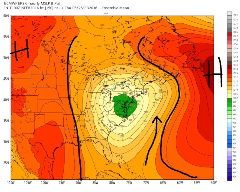
First lets quickly address the weaker Monday threat. Here was the set up from 4days ago:
"By day 6 the LP should move up and out to the NE and the cold frontal boundary should set up somewhere off the east coast. As you can see by the little black circles weak little waves may form along it but you can see a bigger LP gathering over SE Tx and a northern system set to dive into the plains. Im not sure if any of the weak waves along the frontal boundary end up amounting to anything just yet, but the possibility exists.

And here we are today: As you can see a weak wave of LP looks to pass off the coast somewhere south of LI as it rides along the aforementioned frontal boundary. Models still differ on its exact track and intensity. Depending on exactly where and just how strong it is we may see snow showers or light accumulations. Best chance is probably N of I-287/I-80. As of now I think the coastal plain sees light rain but may change to snow showers. This can still trend towards nothing as well. As you can see the does look to be a fresh injection of cold air with HP building during this period so we also may see this trend towards a colder soln if the LP trends a tad stronger.

Now lets focus back in on the bigger threat for mid-late week. Once again the long range teleconnection projections tease us. Like Rb has been pointing out the original +PNA/-EPO/-AO blocking signature that was looking to set up for the system mid-late next week is trending weaker and weaker esp the EPO and AO signals. Recall my concerns from 4days ago regarding this system:
By day 8-10 you can see the southern system comes out and there is going to be an interaction with the northern branch, and a formidable system looks to develop and come up the coast in some way with a decent HP position to the north. You can see by the images there is still plenty of spread, but the means are looking pretty decent at this early stage.


What I dont like is that big old positive(red) in the NW Atlantic. Im worried that it may lead to a track that is inland, although I think the HP and the state of the MJO will help prevent it from cutting as far inland as this one today is. I also hope that the PNA rising trends a tad stronger over time. Signal is strong on GEFS and EPS and op models for a good size storm for the 8-10day. Question is where does it track? We need the PV to be far enough south to prevent the N and S branch from phasing too soon, and immediately cutting when it does. There is still a strong HP trying to build, but the positive heights in the NW Atlantic have to back off a little or center further east to allow the +PNA/-EPO to drive the PV far enough south. Plenty of time to watch. Models will cont to waffle. Lets also see if we can sneak "something" out of an overrunning event in the 6-8day.

Fast foward to last nigts 00z runs.

Plain and simple: Images above: First notice where the center of the trough axis is around the Aleutian Island. Notice it is further N that on the prev run. We need that to be positioned further S of the Islands. This would amp of the jet down stream and allow the PV to sink further S. You can see the PNA ridge is trending nicely; however, its not enough I do believe. The tropical forcing, again as Rb has been hinting at, does not draw the Aleutian trough far enough south, at least not on this model projection verbatim.
In addition: we have lost the HP to the north and the positives in the NW Atlantic are holding strong. Instead of a 50/50 LP which causes blocking and enforces a cold air injection around the counterclockwise winds of a 50/50 low the positives in the NW builds a blocking HP system at or around 50N/50W position and a return flow from the SE similar to the one we encountered on Tuesday ensues. The result is a warm surge of air into the midlevels of an amped up STJ stream system. Without an HP to the N NW of this system the NW Atlantic HP, which escapes before our system arrives, creates a block it but forces it to cut in combination with the Lack of HP to the N and NW of us. Path of least resistance.
Euro ensemble mean:
GFS Ensemble mean:

Here is the EPS MSLP anomaly. 00z 17th notice that the mean LP center was just off the coast and the track was off the coast when the center of the NW Atlantic HP was projected much farther N and E.
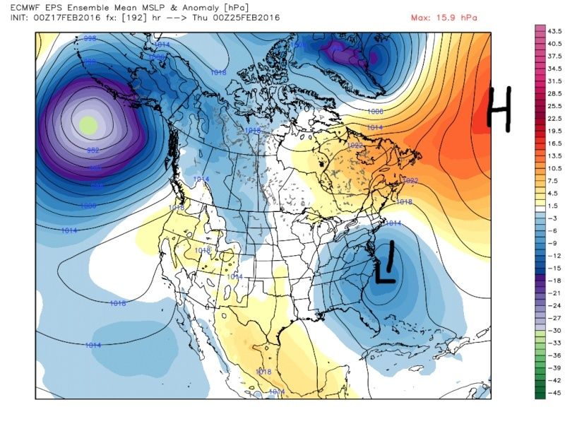
Versus where the MSLP anomalies are on last nights runs. Most important...the position of the HP in the NW Atlantic. Its acting as a block, but it forces the LP track inland and it provides a warm air surge into the system from the S/SE.
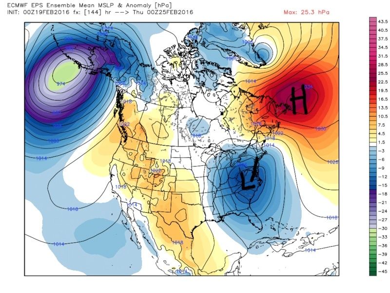
Sorry to be the bearer of bad news here guys, but I am trying to tell it how I see it. I am still confident that we have not seen the final soln yet. Cold air damning could still allow for a front end thumping depending on the exact track, but the trends were not good for a beast of a snowstorm for all of us.
Insult to injury here is the UKIE which again has done pretty well with this sort of set up this winter:
_________________
"In weather and in life, there's no winning and losing; there's only winning and learning."
WINTER 2012/2013 TOTALS 43.65"WINTER 2017/2018 TOTALS 62.85" WINTER 2022/2023 TOTALS 4.9"
WINTER 2013/2014 TOTALS 64.85"WINTER 2018/2019 TOTALS 14.25" WINTER 2023/2024 TOTALS 13.1"
WINTER 2014/2015 TOTALS 71.20"WINTER 2019/2020 TOTALS 6.35"
WINTER 2015/2016 TOTALS 35.00"WINTER 2020/2021 TOTALS 37.75"
WINTER 2016/2017 TOTALS 42.25"WINTER 2021/2022 TOTALS 31.65"

sroc4- Admin
- Posts : 8331
Reputation : 301
Join date : 2013-01-07
Location : Wading River, LI
Re: Long Range Thread 10.0
![]() by RJB8525 Fri Feb 19, 2016 8:23 am
by RJB8525 Fri Feb 19, 2016 8:23 am

RJB8525- Senior Enthusiast
- Posts : 1994
Reputation : 28
Join date : 2013-02-06
Age : 38
Location : Hackettstown, NJ
Re: Long Range Thread 10.0
![]() by skinsfan1177 Fri Feb 19, 2016 8:44 am
by skinsfan1177 Fri Feb 19, 2016 8:44 am

skinsfan1177- Senior Enthusiast
- Posts : 4485
Reputation : 35
Join date : 2013-01-07
Age : 46
Location : Point Pleasant Boro
Re: Long Range Thread 10.0
![]() by weatherwatchermom Fri Feb 19, 2016 8:52 am
by weatherwatchermom Fri Feb 19, 2016 8:52 am

weatherwatchermom- Senior Enthusiast
- Posts : 3730
Reputation : 77
Join date : 2014-11-25
Age : 60
Location : Hazlet Township, NJ
Re: Long Range Thread 10.0
![]() by SNOW MAN Fri Feb 19, 2016 8:53 am
by SNOW MAN Fri Feb 19, 2016 8:53 am
skinsfan1177 wrote:I'm starting to think this may be it lol. Every time the pattern looks to be good well it turns out not good enough.
I'm starting to feel the same way Skins. Where's Mugs I need a boost of optimism.
Last edited by SNOW MAN on Fri Feb 19, 2016 9:10 am; edited 1 time in total

SNOW MAN- Senior Enthusiast
- Posts : 1361
Reputation : 25
Join date : 2013-01-13
Age : 64
Location : Marshalls Creek Pa.
Re: Long Range Thread 10.0
![]() by Guest Fri Feb 19, 2016 9:08 am
by Guest Fri Feb 19, 2016 9:08 am
....with over 40" IMBY I actually and honestly feel like this is one of the most disappointing winters I've ever lived through. 2 storms within a week delivered big time. Erase that week and EVERY other threat has either cut or fizzled. Horrendous winter. Above avg. temps and 2 storms!!! Bullcrap
Guest- Guest
Re: Long Range Thread 10.0
![]() by CPcantmeasuresnow Fri Feb 19, 2016 9:15 am
by CPcantmeasuresnow Fri Feb 19, 2016 9:15 am
syosnow94 wrote:Feel better Frank.
....with over 40" IMBY I actually and honestly feel like this is one of the most disappointing winters I've ever lived through. 2 storms within a week delivered big time. Erase that week and EVERY other threat has either cut or fizzled. Horrendous winter. Above avg. temps and 2 storms!!! Bullcrap
I graded it a D- last week IMBY, an F for the HV as a whole, and a C- in NYC only because of the -1 and Jonas. Take those 2 things away and it's an F so far for everybody.

CPcantmeasuresnow- Wx Statistician Guru

- Posts : 7274
Reputation : 230
Join date : 2013-01-07
Age : 103
Location : Eastern Orange County, NY
Re: Long Range Thread 10.0
![]() by docstox12 Fri Feb 19, 2016 9:29 am
by docstox12 Fri Feb 19, 2016 9:29 am
CPcantmeasuresnow wrote:syosnow94 wrote:Feel better Frank.
....with over 40" IMBY I actually and honestly feel like this is one of the most disappointing winters I've ever lived through. 2 storms within a week delivered big time. Erase that week and EVERY other threat has either cut or fizzled. Horrendous winter. Above avg. temps and 2 storms!!! Bullcrap
I graded it a D- last week IMBY, an F for the HV as a whole, and a C- in NYC only because of the -1 and Jonas. Take those 2 things away and it's an F so far for everybody.
Not to pick nits with you good Buddy, but I'd give the Lower Hudson Valley a D- and the poor guys above I 84 the F.That area has been just horrible this winter.The analog of '82-'83 is playing out so far with that Feb 83 storm the Jonas of that Hellnino year.
However, I choose to always walk on the sunny side of life ( or should I say snowy side) and hope for that big HV Special in early-mid March to even up the score here.At least to get us up to a "C" grade in the HV.

docstox12- Wx Statistician Guru
- Posts : 8497
Reputation : 222
Join date : 2013-01-07
Age : 73
Location : Monroe NY
Re: Long Range Thread 10.0
![]() by chief7 Fri Feb 19, 2016 9:37 am
by chief7 Fri Feb 19, 2016 9:37 am
chief7- Posts : 132
Reputation : 0
Join date : 2013-11-10
Location : Langhorne pa
Re: Long Range Thread 10.0
![]() by kaos00723 Fri Feb 19, 2016 9:44 am
by kaos00723 Fri Feb 19, 2016 9:44 am
kaos00723- Posts : 13
Reputation : 0
Join date : 2016-01-18
Age : 48
Location : Hewitt, NJ
Re: Long Range Thread 10.0
![]() by Guest Fri Feb 19, 2016 9:53 am
by Guest Fri Feb 19, 2016 9:53 am
Guest- Guest
Re: Long Range Thread 10.0
![]() by CPcantmeasuresnow Fri Feb 19, 2016 9:54 am
by CPcantmeasuresnow Fri Feb 19, 2016 9:54 am
docstox12 wrote:CPcantmeasuresnow wrote:syosnow94 wrote:Feel better Frank.
....with over 40" IMBY I actually and honestly feel like this is one of the most disappointing winters I've ever lived through. 2 storms within a week delivered big time. Erase that week and EVERY other threat has either cut or fizzled. Horrendous winter. Above avg. temps and 2 storms!!! Bullcrap
I graded it a D- last week IMBY, an F for the HV as a whole, and a C- in NYC only because of the -1 and Jonas. Take those 2 things away and it's an F so far for everybody.
Not to pick nits with you good Buddy, but I'd give the Lower Hudson Valley a D- and the poor guys above I 84 the F.That area has been just horrible this winter.The analog of '82-'83 is playing out so far with that Feb 83 storm the Jonas of that Hellnino year.
However, I choose to always walk on the sunny side of life ( or should I say snowy side) and hope for that big HV Special in early-mid March to even up the score here.At least to get us up to a "C" grade in the HV.
Doc, please read my posts to the end, I gave our area of the HV a D- and as quoted "an F for the HV as a whole". You're forgiven.
CPcantmeasuresnow- Wx Statistician Guru
- Posts : 7274
Reputation : 230
Join date : 2013-01-07
Age : 103
Location : Eastern Orange County, NY
Re: Long Range Thread 10.0
![]() by sroc4 Fri Feb 19, 2016 9:57 am
by sroc4 Fri Feb 19, 2016 9:57 am
kaos00723 wrote:You guys are hilarious with the model hugging this far out. The chances of it taking that western track the GFS shows is under 3% at best. It doesn't have the slightest clue yet and will continue to be all over the place until Sun/Mon. The energy won't even be on the map until around that time frame either, get a grip!
Kaos...you may be right simply with the fact that the GFS is furthest west and is still lost entirely. Euro and GFS operational models alike are still changing drastically at 500mb from run to run. The GFS should come back east for sure; however, there is no denying the GEFS and the EPS shifting west. That a total of 76 individual model runs (51 Euro members & 25 GFS members) The average of which are showing a track anywhere from Central PA/ Western NY to a coastal hugger. That is not a fluke IMO. Plus there are trends on multiple models, not just the GFS, in other areas of North America which are pointed out and eplained above why a more western track is the most likely, although not set in stone, track. We have seen crazy last minute trends this year, so I am not ruling out anything right now, but your comments are pretty naive. Sorry. No one is hugging a model.
Euro ensemble mean:
GFS Ensemble mean:
_________________
"In weather and in life, there's no winning and losing; there's only winning and learning."
WINTER 2012/2013 TOTALS 43.65"WINTER 2017/2018 TOTALS 62.85" WINTER 2022/2023 TOTALS 4.9"
WINTER 2013/2014 TOTALS 64.85"WINTER 2018/2019 TOTALS 14.25" WINTER 2023/2024 TOTALS 13.1"
WINTER 2014/2015 TOTALS 71.20"WINTER 2019/2020 TOTALS 6.35"
WINTER 2015/2016 TOTALS 35.00"WINTER 2020/2021 TOTALS 37.75"
WINTER 2016/2017 TOTALS 42.25"WINTER 2021/2022 TOTALS 31.65"
sroc4- Admin
- Posts : 8331
Reputation : 301
Join date : 2013-01-07
Location : Wading River, LI
Re: Long Range Thread 10.0
![]() by Frank_Wx Fri Feb 19, 2016 10:00 am
by Frank_Wx Fri Feb 19, 2016 10:00 am
_________________
_______________________________________________________________________________________________________
CLICK HERE to view NJ Strong Snowstorm Classifications
Frank_Wx- Godzilla Seeker
- Posts : 21305
Reputation : 328
Join date : 2013-01-05
Age : 31
Location : Jersey City, NJ -
Re: Long Range Thread 10.0
![]() by jake732 Fri Feb 19, 2016 10:09 am
by jake732 Fri Feb 19, 2016 10:09 am

jake732- Pro Enthusiast

- Posts : 449
Reputation : 0
Join date : 2016-01-03
Location : lakewood, nj -
Re: Long Range Thread 10.0
![]() by Frank_Wx Fri Feb 19, 2016 10:11 am
by Frank_Wx Fri Feb 19, 2016 10:11 am
skinsfan1177 wrote:I'm starting to think this may be it lol. Every time the pattern looks to be good well it turns out not good enough.
jake732 wrote:all rain event for me. see ya next december.
BANTER posts
_________________
_______________________________________________________________________________________________________
CLICK HERE to view NJ Strong Snowstorm Classifications
Frank_Wx- Godzilla Seeker
- Posts : 21305
Reputation : 328
Join date : 2013-01-05
Age : 31
Location : Jersey City, NJ -
Re: Long Range Thread 10.0
![]() by sroc4 Fri Feb 19, 2016 10:44 am
by sroc4 Fri Feb 19, 2016 10:44 am
_________________
"In weather and in life, there's no winning and losing; there's only winning and learning."
WINTER 2012/2013 TOTALS 43.65"WINTER 2017/2018 TOTALS 62.85" WINTER 2022/2023 TOTALS 4.9"
WINTER 2013/2014 TOTALS 64.85"WINTER 2018/2019 TOTALS 14.25" WINTER 2023/2024 TOTALS 13.1"
WINTER 2014/2015 TOTALS 71.20"WINTER 2019/2020 TOTALS 6.35"
WINTER 2015/2016 TOTALS 35.00"WINTER 2020/2021 TOTALS 37.75"
WINTER 2016/2017 TOTALS 42.25"WINTER 2021/2022 TOTALS 31.65"
sroc4- Admin
- Posts : 8331
Reputation : 301
Join date : 2013-01-07
Location : Wading River, LI
Re: Long Range Thread 10.0
![]() by amugs Fri Feb 19, 2016 10:47 am
by amugs Fri Feb 19, 2016 10:47 am
SNOW MAN wrote:skinsfan1177 wrote:I'm starting to think this may be it lol. Every time the pattern looks to be good well it turns out not good enough.
I'm starting to feel the same way Skins. Where's Mugs I need a boost of optimism.
Troops,
Listen up here and listen to me good - I am in no way writing off the mid/late system yet SNAP OUT OF IT!!
We have a =what could be a nice little white gold storm to set things up for the latter part of the week - IF the NAM is write with this system (Monday) then we push that god for saken WAR (West Atlantic ridge) east and up which would allow the storm to get off teh coast or be a coastal hugger. The HP has been underdone IMO and we see this a lot with models and teh position will fluctuate from run to run. We went from a coastal bomb BM to a cutter that cuts to Buffalo in 12 hours - ????
Take one step at a time here but let's all root for the Monday clipper to do some dirty work here cause we will need its help IMO for the later storm.
_________________
Mugs
AKA:King: Snow Weenie
Self Proclaimed
WINTER 2014-15 : 55.12" +.02 for 6 coatings (avg. 35")
WINTER 2015-16 Total - 29.8" (Avg 35")
WINTER 2016-17 : 39.5" so far

amugs- Advanced Forecaster - Mod
- Posts : 15091
Reputation : 213
Join date : 2013-01-07
Age : 54
Location : Hillsdale,NJ
Re: Long Range Thread 10.0
![]() by hyde345 Fri Feb 19, 2016 11:22 am
by hyde345 Fri Feb 19, 2016 11:22 am

hyde345- Pro Enthusiast
- Posts : 1082
Reputation : 48
Join date : 2013-01-08
Location : Hyde Park, NY
Re: Long Range Thread 10.0
![]() by CPcantmeasuresnow Fri Feb 19, 2016 11:23 am
by CPcantmeasuresnow Fri Feb 19, 2016 11:23 am
A very confusing mid week indeed, but at least the GFS is further east but still to warm for the coast. N & W does okay, looks like 4-8 or so. Again numbers and operational runs are pretty meaningless because I see nothing close to any kind of consensus.
As I stated yesterday it's not even that there is model disagreement, each model disagrees with itself from run to run.
CPcantmeasuresnow- Wx Statistician Guru
- Posts : 7274
Reputation : 230
Join date : 2013-01-07
Age : 103
Location : Eastern Orange County, NY
Re: Long Range Thread 10.0
![]() by SNOW MAN Fri Feb 19, 2016 11:32 am
by SNOW MAN Fri Feb 19, 2016 11:32 am
amugs wrote:SNOW MAN wrote:skinsfan1177 wrote:I'm starting to think this may be it lol. Every time the pattern looks to be good well it turns out not good enough.
I'm starting to feel the same way Skins. Where's Mugs I need a boost of optimism.
Troops,
Listen up here and listen to me good - I am in no way writing off the mid/late system yet SNAP OUT OF IT!!
We have a =what could be a nice little white gold storm to set things up for the latter part of the week - IF the NAM is write with this system (Monday) then we push that god for saken WAR (West Atlantic ridge) east and up which would allow the storm to get off teh coast or be a coastal hugger. The HP has been underdone IMO and we see this a lot with models and teh position will fluctuate from run to run. We went from a coastal bomb BM to a cutter that cuts to Buffalo in 12 hours - ????
Take one step at a time here but let's all root for the Monday clipper to do some dirty work here cause we will need its help IMO for the later storm.

I feel like I was just slapped by General Patton. Thank you.
SNOW MAN- Senior Enthusiast
- Posts : 1361
Reputation : 25
Join date : 2013-01-13
Age : 64
Location : Marshalls Creek Pa.
Re: Long Range Thread 10.0
![]() by algae888 Fri Feb 19, 2016 12:32 pm
by algae888 Fri Feb 19, 2016 12:32 pm

algae888- Advanced Forecaster

- Posts : 5311
Reputation : 46
Join date : 2013-02-05
Age : 61
Location : mt. vernon, new york
Re: Long Range Thread 10.0
![]() by jimv45 Fri Feb 19, 2016 12:53 pm
by jimv45 Fri Feb 19, 2016 12:53 pm
jimv45- Senior Enthusiast
- Posts : 1168
Reputation : 36
Join date : 2013-09-20
Location : Hopewell jct.
Page 24 of 28 • 1 ... 13 ... 23, 24, 25, 26, 27, 28 ![]()
|
|
|