
 Search
02/05 "Surprise" Storm Obs. / Final Call Snow Map
Page 2 of 12 •  1, 2, 3, ... 10, 11, 12
 ![]()
Re: 02/05 "Surprise" Storm Obs. / Final Call Snow Map
![]() by Frank_Wx Thu Feb 04, 2016 8:52 pm
by Frank_Wx Thu Feb 04, 2016 8:52 pm
NjWeatherGuy wrote:I must say radar trends arent too great looking. Not seeing much in the way of westward expansion of precip shield and find QPF numbers some models print out here hard to believe. But ill be up late tonight so well see how this unfolds.
Dynamics are not in play yet. They won't be until the middle of the night.
Fededle22 wrote:So what is the expected timing for this storm? I saw that you are saying changeover between 2-4am but how long will it be snowing for us in the 4-7" range? Just trying to plan the day with the wife and kids. Thanks for all of your help guys. By the way, does the fact that this storm is having such as impact on us now, impact our chances for next weeks storm(s)?
It'll end between 11am-1pm. And no, I don't see this storm impacting next week's setup. If you read my blog from that thread you'll see there is a second wave that develops off the coast late Sunday that could affect the Tuesday storm.
Frank_Wx- Godzilla Seeker

- Posts : 21305
Join date : 2013-01-05 -

Re: 02/05 "Surprise" Storm Obs. / Final Call Snow Map
![]() by NjWeatherGuy Thu Feb 04, 2016 8:55 pm
by NjWeatherGuy Thu Feb 04, 2016 8:55 pm
Yeah just looked at how its forecast to unfold via RAP composite reflectivity, 0z QPF totals out momentarily, looks to hold serveFrank_Wx wrote:NjWeatherGuy wrote:I must say radar trends arent too great looking. Not seeing much in the way of westward expansion of precip shield and find QPF numbers some models print out here hard to believe. But ill be up late tonight so well see how this unfolds.
Dynamics are not in play yet. They won't be until the middle of the night.Fededle22 wrote:So what is the expected timing for this storm? I saw that you are saying changeover between 2-4am but how long will it be snowing for us in the 4-7" range? Just trying to plan the day with the wife and kids. Thanks for all of your help guys. By the way, does the fact that this storm is having such as impact on us now, impact our chances for next weeks storm(s)?
It'll end between 11am-1pm. And no, I don't see this storm impacting next week's setup. If you read my blog from that thread you'll see there is a second wave that develops off the coast late Sunday that could affect the Tuesday storm.
NjWeatherGuy- Advanced Forecaster

- Posts : 4100
Join date : 2013-01-06
Re: 02/05 "Surprise" Storm Obs. / Final Call Snow Map
![]() by Frank_Wx Thu Feb 04, 2016 8:56 pm
by Frank_Wx Thu Feb 04, 2016 8:56 pm

_________________
_______________________________________________________________________________________________________
CLICK HERE to view NJ Strong Snowstorm Classifications

Frank_Wx- Godzilla Seeker
- Posts : 21305
Reputation : 328
Join date : 2013-01-05
Age : 31
Location : Jersey City, NJ -
Re: 02/05 "Surprise" Storm Obs. / Final Call Snow Map
![]() by Frank_Wx Thu Feb 04, 2016 8:57 pm
by Frank_Wx Thu Feb 04, 2016 8:57 pm
_________________
_______________________________________________________________________________________________________
CLICK HERE to view NJ Strong Snowstorm Classifications
Frank_Wx- Godzilla Seeker
- Posts : 21305
Reputation : 328
Join date : 2013-01-05
Age : 31
Location : Jersey City, NJ -
Re: 02/05 "Surprise" Storm Obs. / Final Call Snow Map
![]() by NjWeatherGuy Thu Feb 04, 2016 8:58 pm
by NjWeatherGuy Thu Feb 04, 2016 8:58 pm
http://www.twisterdata.com/index.php?prog=forecast&model=RAP&grid=255&model_yyyy=2016&model_mm=02&model_dd=05&model_init_hh=00&fhour=17¶meter=PCPIN&level=15&unit=HR&maximize=n&mode=singlemap&sounding=n&output=image&view=large&archive=false

NjWeatherGuy- Advanced Forecaster
- Posts : 4100
Reputation : 28
Join date : 2013-01-06
Location : Belle Mead, NJ
Re: 02/05 "Surprise" Storm Obs. / Final Call Snow Map
![]() by NjWeatherGuy Thu Feb 04, 2016 9:00 pm
by NjWeatherGuy Thu Feb 04, 2016 9:00 pm
Frank_Wx wrote:00z NAM has sharp cutoff for NW people. Hopefully there's another frontogenesis to expand the snow bands west enough. Now cast event
Looks slightly NW from 18z, or about the same
http://mp1.met.psu.edu/~fxg1/ETAPA_18z/etaloop.html#picture
NjWeatherGuy- Advanced Forecaster
- Posts : 4100
Reputation : 28
Join date : 2013-01-06
Location : Belle Mead, NJ
Re: 02/05 "Surprise" Storm Obs. / Final Call Snow Map
![]() by Frank_Wx Thu Feb 04, 2016 9:01 pm
by Frank_Wx Thu Feb 04, 2016 9:01 pm
0z NAM

18z NAM

Like this
_________________
_______________________________________________________________________________________________________
CLICK HERE to view NJ Strong Snowstorm Classifications
Frank_Wx- Godzilla Seeker
- Posts : 21305
Reputation : 328
Join date : 2013-01-05
Age : 31
Location : Jersey City, NJ -
Re: 02/05 "Surprise" Storm Obs. / Final Call Snow Map
![]() by CPcantmeasuresnow Thu Feb 04, 2016 9:03 pm
by CPcantmeasuresnow Thu Feb 04, 2016 9:03 pm
Frank_Wx wrote:00z NAM has sharp cutoff for NW people. Hopefully there's another frontogenesis to expand the snow bands west enough. Now cast event
No biggie, we're use to it.

CPcantmeasuresnow- Wx Statistician Guru

- Posts : 7274
Reputation : 230
Join date : 2013-01-07
Age : 103
Location : Eastern Orange County, NY
Re: 02/05 "Surprise" Storm Obs. / Final Call Snow Map
![]() by Frank_Wx Thu Feb 04, 2016 9:05 pm
by Frank_Wx Thu Feb 04, 2016 9:05 pm

_________________
_______________________________________________________________________________________________________
CLICK HERE to view NJ Strong Snowstorm Classifications
Frank_Wx- Godzilla Seeker
- Posts : 21305
Reputation : 328
Join date : 2013-01-05
Age : 31
Location : Jersey City, NJ -
Re: 02/05 "Surprise" Storm Obs. / Final Call Snow Map
![]() by snow247 Thu Feb 04, 2016 9:05 pm
by snow247 Thu Feb 04, 2016 9:05 pm
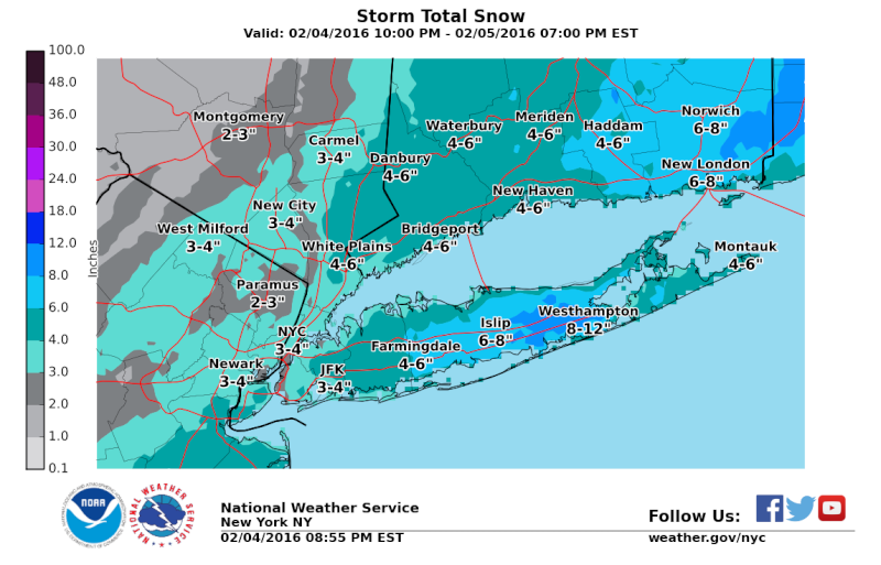
Also noticed Orange County was added to the advisories, 2-4.

snow247- Pro Enthusiast

- Posts : 2417
Reputation : 0
Join date : 2014-08-27
Location : Mount Ivy, NY - Elevation 545'
Re: 02/05 "Surprise" Storm Obs. / Final Call Snow Map
![]() by Frank_Wx Thu Feb 04, 2016 9:06 pm
by Frank_Wx Thu Feb 04, 2016 9:06 pm

_________________
_______________________________________________________________________________________________________
CLICK HERE to view NJ Strong Snowstorm Classifications
Frank_Wx- Godzilla Seeker
- Posts : 21305
Reputation : 328
Join date : 2013-01-05
Age : 31
Location : Jersey City, NJ -
Re: 02/05 "Surprise" Storm Obs. / Final Call Snow Map
![]() by NjWeatherGuy Thu Feb 04, 2016 9:07 pm
by NjWeatherGuy Thu Feb 04, 2016 9:07 pm
NjWeatherGuy- Advanced Forecaster
- Posts : 4100
Reputation : 28
Join date : 2013-01-06
Location : Belle Mead, NJ
Re: 02/05 "Surprise" Storm Obs. / Final Call Snow Map
![]() by snow247 Thu Feb 04, 2016 9:10 pm
by snow247 Thu Feb 04, 2016 9:10 pm
snow247- Pro Enthusiast
- Posts : 2417
Reputation : 0
Join date : 2014-08-27
Location : Mount Ivy, NY - Elevation 545'
Re: 02/05 "Surprise" Storm Obs. / Final Call Snow Map
![]() by aiannone Thu Feb 04, 2016 9:12 pm
by aiannone Thu Feb 04, 2016 9:12 pm
_________________
-Alex Iannone-

aiannone- Senior Enthusiast - Mod

- Posts : 4813
Reputation : 92
Join date : 2013-01-07
Location : Saint James, LI (Northwest Suffolk Co.)
Re: 02/05 "Surprise" Storm Obs. / Final Call Snow Map
![]() by NjWeatherGuy Thu Feb 04, 2016 9:13 pm
by NjWeatherGuy Thu Feb 04, 2016 9:13 pm
http://mp1.met.psu.edu/~fxg1/SREF21PRSNE_21z/srefloop.html#picture
Still quite a spread, some really wind it up and some are a little faster to move it along, still a decent mean and a nowcast for sure
NjWeatherGuy- Advanced Forecaster
- Posts : 4100
Reputation : 28
Join date : 2013-01-06
Location : Belle Mead, NJ
Re: 02/05 "Surprise" Storm Obs. / Final Call Snow Map
![]() by NjWeatherGuy Thu Feb 04, 2016 9:22 pm
by NjWeatherGuy Thu Feb 04, 2016 9:22 pm
Closest location to my house
https://www.google.com/maps/place/Montgomery+Volunteer+Fire+Department+1,+35+Belle+Mead+Griggstown+Road,+Belle+Mead,+NJ+08502,+United+States/@40.2315521,-74.7761644,10z/data=!4m2!3m1!1s0x89c3e91b9427621d:0x6b1bf1cde069eb52
NjWeatherGuy- Advanced Forecaster
- Posts : 4100
Reputation : 28
Join date : 2013-01-06
Location : Belle Mead, NJ
Re: 02/05 "Surprise" Storm Obs. / Final Call Snow Map
![]() by sroc4 Thu Feb 04, 2016 9:23 pm
by sroc4 Thu Feb 04, 2016 9:23 pm
aiannone wrote:WSW for Suffolk County, LI now. 5-8"
Anyone else having trouble with their main website?
_________________
"In weather and in life, there's no winning and losing; there's only winning and learning."
WINTER 2012/2013 TOTALS 43.65"WINTER 2017/2018 TOTALS 62.85" WINTER 2022/2023 TOTALS 4.9"
WINTER 2013/2014 TOTALS 64.85"WINTER 2018/2019 TOTALS 14.25" WINTER 2023/2024 TOTALS 13.1"
WINTER 2014/2015 TOTALS 71.20"WINTER 2019/2020 TOTALS 6.35"
WINTER 2015/2016 TOTALS 35.00"WINTER 2020/2021 TOTALS 37.75"
WINTER 2016/2017 TOTALS 42.25"WINTER 2021/2022 TOTALS 31.65"

sroc4- Admin
- Posts : 8331
Reputation : 301
Join date : 2013-01-07
Location : Wading River, LI
Re: 02/05 "Surprise" Storm Obs. / Final Call Snow Map
![]() by bloc1357 Thu Feb 04, 2016 9:27 pm
by bloc1357 Thu Feb 04, 2016 9:27 pm
sroc4 wrote:aiannone wrote:WSW for Suffolk County, LI now. 5-8"
Anyone else having trouble with their main website?
yeah, uptons main page won't load. If I use new york it is fine
bloc1357- Pro Enthusiast
- Posts : 344
Reputation : 10
Join date : 2013-03-05
Age : 47
Location : West Babylon, NY - 11704
Re: 02/05 "Surprise" Storm Obs. / Final Call Snow Map
![]() by aiannone Thu Feb 04, 2016 9:29 pm
by aiannone Thu Feb 04, 2016 9:29 pm
_________________
-Alex Iannone-
aiannone- Senior Enthusiast - Mod
- Posts : 4813
Reputation : 92
Join date : 2013-01-07
Location : Saint James, LI (Northwest Suffolk Co.)
Re: 02/05 "Surprise" Storm Obs. / Final Call Snow Map
![]() by NjWeatherGuy Thu Feb 04, 2016 9:38 pm
by NjWeatherGuy Thu Feb 04, 2016 9:38 pm
NjWeatherGuy- Advanced Forecaster
- Posts : 4100
Reputation : 28
Join date : 2013-01-06
Location : Belle Mead, NJ
Re: 02/05 "Surprise" Storm Obs. / Final Call Snow Map
![]() by Math23x7 Thu Feb 04, 2016 9:39 pm
by Math23x7 Thu Feb 04, 2016 9:39 pm
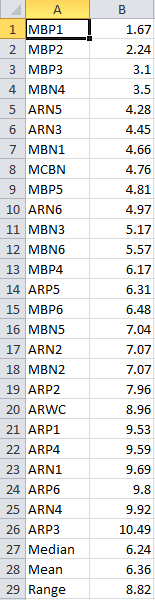
As shown above, the mean is ~6.36" and the median is ~6.24!
Math23x7- Wx Statistician Guru
- Posts : 2379
Reputation : 68
Join date : 2013-01-08
Re: 02/05 "Surprise" Storm Obs. / Final Call Snow Map
![]() by snow247 Thu Feb 04, 2016 9:40 pm
by snow247 Thu Feb 04, 2016 9:40 pm
Last edited by snow247 on Thu Feb 04, 2016 9:42 pm; edited 1 time in total
snow247- Pro Enthusiast
- Posts : 2417
Reputation : 0
Join date : 2014-08-27
Location : Mount Ivy, NY - Elevation 545'
Re: 02/05 "Surprise" Storm Obs. / Final Call Snow Map
![]() by sroc4 Thu Feb 04, 2016 9:40 pm
by sroc4 Thu Feb 04, 2016 9:40 pm
aiannone wrote:

_________________
"In weather and in life, there's no winning and losing; there's only winning and learning."
WINTER 2012/2013 TOTALS 43.65"WINTER 2017/2018 TOTALS 62.85" WINTER 2022/2023 TOTALS 4.9"
WINTER 2013/2014 TOTALS 64.85"WINTER 2018/2019 TOTALS 14.25" WINTER 2023/2024 TOTALS 13.1"
WINTER 2014/2015 TOTALS 71.20"WINTER 2019/2020 TOTALS 6.35"
WINTER 2015/2016 TOTALS 35.00"WINTER 2020/2021 TOTALS 37.75"
WINTER 2016/2017 TOTALS 42.25"WINTER 2021/2022 TOTALS 31.65"
sroc4- Admin
- Posts : 8331
Reputation : 301
Join date : 2013-01-07
Location : Wading River, LI
Re: 02/05 "Surprise" Storm Obs. / Final Call Snow Map
![]() by amugs Thu Feb 04, 2016 9:44 pm
by amugs Thu Feb 04, 2016 9:44 pm
NjWeatherGuy wrote:http://www.ssd.noaa.gov/goes/east/eaus/wv-animated.gif
THAT IS A BEAUTIFUL FETCH OF MOISTURE!!!!
_________________
Mugs
AKA:King: Snow Weenie
Self Proclaimed
WINTER 2014-15 : 55.12" +.02 for 6 coatings (avg. 35")
WINTER 2015-16 Total - 29.8" (Avg 35")
WINTER 2016-17 : 39.5" so far

amugs- Advanced Forecaster - Mod
- Posts : 15091
Reputation : 213
Join date : 2013-01-07
Age : 54
Location : Hillsdale,NJ
Re: 02/05 "Surprise" Storm Obs. / Final Call Snow Map
![]() by sroc4 Thu Feb 04, 2016 9:45 pm
by sroc4 Thu Feb 04, 2016 9:45 pm
amugs wrote:NjWeatherGuy wrote:http://www.ssd.noaa.gov/goes/east/eaus/wv-animated.gif
THAT IS A BEAUTIFUL FETCH OF MOISTURE!!!!

_________________
"In weather and in life, there's no winning and losing; there's only winning and learning."
WINTER 2012/2013 TOTALS 43.65"WINTER 2017/2018 TOTALS 62.85" WINTER 2022/2023 TOTALS 4.9"
WINTER 2013/2014 TOTALS 64.85"WINTER 2018/2019 TOTALS 14.25" WINTER 2023/2024 TOTALS 13.1"
WINTER 2014/2015 TOTALS 71.20"WINTER 2019/2020 TOTALS 6.35"
WINTER 2015/2016 TOTALS 35.00"WINTER 2020/2021 TOTALS 37.75"
WINTER 2016/2017 TOTALS 42.25"WINTER 2021/2022 TOTALS 31.65"
sroc4- Admin
- Posts : 8331
Reputation : 301
Join date : 2013-01-07
Location : Wading River, LI
Re: 02/05 "Surprise" Storm Obs. / Final Call Snow Map
![]() by Frank_Wx Thu Feb 04, 2016 9:48 pm
by Frank_Wx Thu Feb 04, 2016 9:48 pm

_________________
_______________________________________________________________________________________________________
CLICK HERE to view NJ Strong Snowstorm Classifications
Frank_Wx- Godzilla Seeker
- Posts : 21305
Reputation : 328
Join date : 2013-01-05
Age : 31
Location : Jersey City, NJ -
Re: 02/05 "Surprise" Storm Obs. / Final Call Snow Map
![]() by Frank_Wx Thu Feb 04, 2016 9:52 pm
by Frank_Wx Thu Feb 04, 2016 9:52 pm


_________________
_______________________________________________________________________________________________________
CLICK HERE to view NJ Strong Snowstorm Classifications
Frank_Wx- Godzilla Seeker
- Posts : 21305
Reputation : 328
Join date : 2013-01-05
Age : 31
Location : Jersey City, NJ -
Page 2 of 12 • 1, 2, 3, ... 10, 11, 12 ![]()
|
|
|