
 Search
February 8, 2016 Snowfall Observations & Discussions
Page 6 of 20 •  1 ... 5, 6, 7 ... 13 ... 20
 ![]()
Re: February 8, 2016 Snowfall Observations & Discussions
![]() by Frank_Wx Sun Feb 07, 2016 10:28 am
by Frank_Wx Sun Feb 07, 2016 10:28 am
weatherwatchermom wrote:gfs is up next right..
HEATMISER wrote:How much long till we see what the gfs says
At hour 6
Frank_Wx- Godzilla Seeker

- Posts : 21305
Join date : 2013-01-05 -

Re: February 8, 2016 Snowfall Observations & Discussions
![]() by CPcantmeasuresnow Sun Feb 07, 2016 10:30 am
by CPcantmeasuresnow Sun Feb 07, 2016 10:30 am
Frank_Wx wrote:This is amazing. Look at the trough over the Great Lakes digging south and east as the beast storm moves up the coast.

Any chance they phase, or to late and to far apart at this juncture.
CPcantmeasuresnow- Wx Statistician Guru

- Posts : 7274
Join date : 2013-01-07
Re: February 8, 2016 Snowfall Observations & Discussions
![]() by sroc4 Sun Feb 07, 2016 10:30 am
by sroc4 Sun Feb 07, 2016 10:30 am

_________________
"In weather and in life, there's no winning and losing; there's only winning and learning."
WINTER 2012/2013 TOTALS 43.65"WINTER 2017/2018 TOTALS 62.85" WINTER 2022/2023 TOTALS 4.9"
WINTER 2013/2014 TOTALS 64.85"WINTER 2018/2019 TOTALS 14.25" WINTER 2023/2024 TOTALS 13.1"
WINTER 2014/2015 TOTALS 71.20"WINTER 2019/2020 TOTALS 6.35"
WINTER 2015/2016 TOTALS 35.00"WINTER 2020/2021 TOTALS 37.75"
WINTER 2016/2017 TOTALS 42.25"WINTER 2021/2022 TOTALS 31.65"

sroc4- Admin
- Posts : 8331
Reputation : 301
Join date : 2013-01-07
Location : Wading River, LI
Re: February 8, 2016 Snowfall Observations & Discussions
![]() by Frank_Wx Sun Feb 07, 2016 10:32 am
by Frank_Wx Sun Feb 07, 2016 10:32 am
CPcantmeasuresnow wrote:Frank_Wx wrote:This is amazing. Look at the trough over the Great Lakes digging south and east as the beast storm moves up the coast.
Any chance they phase, or to late and to far apart at this juncture.
Too late. The southern energy is too far south and east. The friction in the atmosphere between the two will allow snow squalls to break out across the northeast late Monday into Tuesday. Very unstable atmosphere
_________________
_______________________________________________________________________________________________________
CLICK HERE to view NJ Strong Snowstorm Classifications

Frank_Wx- Godzilla Seeker
- Posts : 21305
Reputation : 328
Join date : 2013-01-05
Age : 31
Location : Jersey City, NJ -
Re: February 8, 2016 Snowfall Observations & Discussions
![]() by sroc4 Sun Feb 07, 2016 10:32 am
by sroc4 Sun Feb 07, 2016 10:32 am
WRF ARW model:

WRF-NMM model:

_________________
"In weather and in life, there's no winning and losing; there's only winning and learning."
WINTER 2012/2013 TOTALS 43.65"WINTER 2017/2018 TOTALS 62.85" WINTER 2022/2023 TOTALS 4.9"
WINTER 2013/2014 TOTALS 64.85"WINTER 2018/2019 TOTALS 14.25" WINTER 2023/2024 TOTALS 13.1"
WINTER 2014/2015 TOTALS 71.20"WINTER 2019/2020 TOTALS 6.35"
WINTER 2015/2016 TOTALS 35.00"WINTER 2020/2021 TOTALS 37.75"
WINTER 2016/2017 TOTALS 42.25"WINTER 2021/2022 TOTALS 31.65"
sroc4- Admin
- Posts : 8331
Reputation : 301
Join date : 2013-01-07
Location : Wading River, LI
Re: February 8, 2016 Snowfall Observations & Discussions
![]() by weatherwatchermom Sun Feb 07, 2016 10:32 am
by weatherwatchermom Sun Feb 07, 2016 10:32 am
Frank_Wx wrote:This is amazing. Look at the trough over the Great Lakes digging south and east as the beast storm moves up the coast.
it is amazing...
i also like to look at this when storms are coming
http://earth.nullschool.net/#current/wind/surface/level/orthographic=-77.53,30.55,891/loc=-73.577,40.085 is that what a ccb looks like?

weatherwatchermom- Senior Enthusiast

- Posts : 3729
Reputation : 77
Join date : 2014-11-25
Age : 60
Location : Hazlet Township, NJ
Re: February 8, 2016 Snowfall Observations & Discussions
![]() by Frank_Wx Sun Feb 07, 2016 10:36 am
by Frank_Wx Sun Feb 07, 2016 10:36 am


HUGE SHIFT BY THE GFS
_________________
_______________________________________________________________________________________________________
CLICK HERE to view NJ Strong Snowstorm Classifications
Frank_Wx- Godzilla Seeker
- Posts : 21305
Reputation : 328
Join date : 2013-01-05
Age : 31
Location : Jersey City, NJ -
Re: February 8, 2016 Snowfall Observations & Discussions
![]() by sroc4 Sun Feb 07, 2016 10:36 am
by sroc4 Sun Feb 07, 2016 10:36 am


_________________
"In weather and in life, there's no winning and losing; there's only winning and learning."
WINTER 2012/2013 TOTALS 43.65"WINTER 2017/2018 TOTALS 62.85" WINTER 2022/2023 TOTALS 4.9"
WINTER 2013/2014 TOTALS 64.85"WINTER 2018/2019 TOTALS 14.25" WINTER 2023/2024 TOTALS 13.1"
WINTER 2014/2015 TOTALS 71.20"WINTER 2019/2020 TOTALS 6.35"
WINTER 2015/2016 TOTALS 35.00"WINTER 2020/2021 TOTALS 37.75"
WINTER 2016/2017 TOTALS 42.25"WINTER 2021/2022 TOTALS 31.65"
sroc4- Admin
- Posts : 8331
Reputation : 301
Join date : 2013-01-07
Location : Wading River, LI
Re: February 8, 2016 Snowfall Observations & Discussions
![]() by sroc4 Sun Feb 07, 2016 10:37 am
by sroc4 Sun Feb 07, 2016 10:37 am
_________________
"In weather and in life, there's no winning and losing; there's only winning and learning."
WINTER 2012/2013 TOTALS 43.65"WINTER 2017/2018 TOTALS 62.85" WINTER 2022/2023 TOTALS 4.9"
WINTER 2013/2014 TOTALS 64.85"WINTER 2018/2019 TOTALS 14.25" WINTER 2023/2024 TOTALS 13.1"
WINTER 2014/2015 TOTALS 71.20"WINTER 2019/2020 TOTALS 6.35"
WINTER 2015/2016 TOTALS 35.00"WINTER 2020/2021 TOTALS 37.75"
WINTER 2016/2017 TOTALS 42.25"WINTER 2021/2022 TOTALS 31.65"
sroc4- Admin
- Posts : 8331
Reputation : 301
Join date : 2013-01-07
Location : Wading River, LI
Re: February 8, 2016 Snowfall Observations & Discussions
![]() by Frank_Wx Sun Feb 07, 2016 10:37 am
by Frank_Wx Sun Feb 07, 2016 10:37 am

_________________
_______________________________________________________________________________________________________
CLICK HERE to view NJ Strong Snowstorm Classifications
Frank_Wx- Godzilla Seeker
- Posts : 21305
Reputation : 328
Join date : 2013-01-05
Age : 31
Location : Jersey City, NJ -
Re: February 8, 2016 Snowfall Observations & Discussions
![]() by Guest Sun Feb 07, 2016 10:40 am
by Guest Sun Feb 07, 2016 10:40 am
Guest- Guest
Re: February 8, 2016 Snowfall Observations & Discussions
![]() by sroc4 Sun Feb 07, 2016 10:40 am
by sroc4 Sun Feb 07, 2016 10:40 am

_________________
"In weather and in life, there's no winning and losing; there's only winning and learning."
WINTER 2012/2013 TOTALS 43.65"WINTER 2017/2018 TOTALS 62.85" WINTER 2022/2023 TOTALS 4.9"
WINTER 2013/2014 TOTALS 64.85"WINTER 2018/2019 TOTALS 14.25" WINTER 2023/2024 TOTALS 13.1"
WINTER 2014/2015 TOTALS 71.20"WINTER 2019/2020 TOTALS 6.35"
WINTER 2015/2016 TOTALS 35.00"WINTER 2020/2021 TOTALS 37.75"
WINTER 2016/2017 TOTALS 42.25"WINTER 2021/2022 TOTALS 31.65"
sroc4- Admin
- Posts : 8331
Reputation : 301
Join date : 2013-01-07
Location : Wading River, LI
Re: February 8, 2016 Snowfall Observations & Discussions
![]() by snow247 Sun Feb 07, 2016 10:40 am
by snow247 Sun Feb 07, 2016 10:40 am
Thoughts?

snow247- Pro Enthusiast

- Posts : 2417
Reputation : 0
Join date : 2014-08-27
Location : Mount Ivy, NY - Elevation 545'
Re: February 8, 2016 Snowfall Observations & Discussions
![]() by Frank_Wx Sun Feb 07, 2016 10:43 am
by Frank_Wx Sun Feb 07, 2016 10:43 am
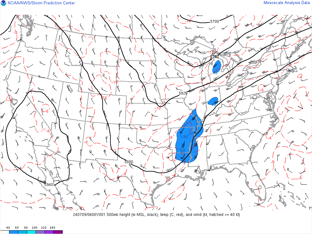
sroc4 wrote:Look GFS has same initiation issue as NAM. Current conditions vs 12z GFS initialization at 500mb. Trough in the SW is neutral on the GFS and even closed already; wheeas current observations clearly tilt it neg. Honestly further NW shift relative towhat GFS is showing is likely IMO
Fantastic observation
_________________
_______________________________________________________________________________________________________
CLICK HERE to view NJ Strong Snowstorm Classifications
Frank_Wx- Godzilla Seeker
- Posts : 21305
Reputation : 328
Join date : 2013-01-05
Age : 31
Location : Jersey City, NJ -
Re: February 8, 2016 Snowfall Observations & Discussions
![]() by sroc4 Sun Feb 07, 2016 10:43 am
by sroc4 Sun Feb 07, 2016 10:43 am

Last edited by sroc4 on Sun Feb 07, 2016 10:44 am; edited 1 time in total
_________________
"In weather and in life, there's no winning and losing; there's only winning and learning."
WINTER 2012/2013 TOTALS 43.65"WINTER 2017/2018 TOTALS 62.85" WINTER 2022/2023 TOTALS 4.9"
WINTER 2013/2014 TOTALS 64.85"WINTER 2018/2019 TOTALS 14.25" WINTER 2023/2024 TOTALS 13.1"
WINTER 2014/2015 TOTALS 71.20"WINTER 2019/2020 TOTALS 6.35"
WINTER 2015/2016 TOTALS 35.00"WINTER 2020/2021 TOTALS 37.75"
WINTER 2016/2017 TOTALS 42.25"WINTER 2021/2022 TOTALS 31.65"
sroc4- Admin
- Posts : 8331
Reputation : 301
Join date : 2013-01-07
Location : Wading River, LI
Re: February 8, 2016 Snowfall Observations & Discussions
![]() by Frank_Wx Sun Feb 07, 2016 10:44 am
by Frank_Wx Sun Feb 07, 2016 10:44 am
syosnow94 wrote:If you look at the water vapor loop the lip off sc looks as if it moves NE then briefly slows and now wobbles slightly west of due north. Plus the wind streams I remember you guys pointing out just before Jonas are pointing due north until south jersey when they begin to point NE. What's the chances all the models completely messed this up? (For the good)
GFS just came NW to bring light snow into LI. I think if this keeps trending more folks will get into light accumulations and LI will get into moderate ones
_________________
_______________________________________________________________________________________________________
CLICK HERE to view NJ Strong Snowstorm Classifications
Frank_Wx- Godzilla Seeker
- Posts : 21305
Reputation : 328
Join date : 2013-01-05
Age : 31
Location : Jersey City, NJ -
Re: February 8, 2016 Snowfall Observations & Discussions
![]() by snow247 Sun Feb 07, 2016 10:46 am
by snow247 Sun Feb 07, 2016 10:46 am
snow247- Pro Enthusiast
- Posts : 2417
Reputation : 0
Join date : 2014-08-27
Location : Mount Ivy, NY - Elevation 545'
Re: February 8, 2016 Snowfall Observations & Discussions
![]() by Frank_Wx Sun Feb 07, 2016 10:46 am
by Frank_Wx Sun Feb 07, 2016 10:46 am
_________________
_______________________________________________________________________________________________________
CLICK HERE to view NJ Strong Snowstorm Classifications
Frank_Wx- Godzilla Seeker
- Posts : 21305
Reputation : 328
Join date : 2013-01-05
Age : 31
Location : Jersey City, NJ -
Re: February 8, 2016 Snowfall Observations & Discussions
![]() by sroc4 Sun Feb 07, 2016 10:50 am
by sroc4 Sun Feb 07, 2016 10:50 am
Frank_Wx wrote:Sroc just realized your time stamp for mesoanalysis is 15z. Your comparing against 12z models. That's why they're different
Im not sure I completely understand. In theory the model image should indicate a time frame later than the current observation right? ie: valid for the 18z timeframe, vs the 15z current observation. So the trough is neg already whereas the GFS wants to keep it positive in its depiction for 18z. This is a good thing right? Or am I interpreting this wrong?
_________________
"In weather and in life, there's no winning and losing; there's only winning and learning."
WINTER 2012/2013 TOTALS 43.65"WINTER 2017/2018 TOTALS 62.85" WINTER 2022/2023 TOTALS 4.9"
WINTER 2013/2014 TOTALS 64.85"WINTER 2018/2019 TOTALS 14.25" WINTER 2023/2024 TOTALS 13.1"
WINTER 2014/2015 TOTALS 71.20"WINTER 2019/2020 TOTALS 6.35"
WINTER 2015/2016 TOTALS 35.00"WINTER 2020/2021 TOTALS 37.75"
WINTER 2016/2017 TOTALS 42.25"WINTER 2021/2022 TOTALS 31.65"
sroc4- Admin
- Posts : 8331
Reputation : 301
Join date : 2013-01-07
Location : Wading River, LI
Re: February 8, 2016 Snowfall Observations & Discussions
![]() by SNOW MAN Sun Feb 07, 2016 10:53 am
by SNOW MAN Sun Feb 07, 2016 10:53 am
Frank_Wx wrote:CPcantmeasuresnow wrote:As one of the more outspoken residents of the snow starved HV, and I've actually had it better here than most, after seeing the last NAM run bury LI again, we do hereby surrender this winter season to the Jersey shore, NYC and LI.
I am done at least for the day. I am taking up residence for the rest of the week on my beloved OTI and my 30 year average snowfall thread.

I'm pretty sure everyone will see accumulating snow Monday-Tuesday. Just a matter of determining how much. I'm very close to saying 2-4 incheS for everyone (both days combined) WITH POCKETS OF 6"+ WHERE THE IVT SETS UP.
Frank would this include the Morris county and EPA area or just Eastern most sections of NJ ? I have a feeling this Winter season (snow wise) is pretty much over in my neck of the woods. It just seems we're always on the very edge of all these systems this year.
The only hope I have for a decent snowfall is maybe between the 15th and 18th. The Mets out at Penn State spoke about this event in the 12 day outlook Friday evening. The only thing that made me nervous about this one was they said it could be a mixed event. Thanks.

SNOW MAN- Senior Enthusiast
- Posts : 1361
Reputation : 25
Join date : 2013-01-13
Age : 64
Location : Marshalls Creek Pa.
Re: February 8, 2016 Snowfall Observations & Discussions
![]() by Quietace Sun Feb 07, 2016 10:55 am
by Quietace Sun Feb 07, 2016 10:55 am

Quietace- Meteorologist - Mod

- Posts : 3687
Reputation : 33
Join date : 2013-01-07
Age : 27
Location : Point Pleasant, NJ
Re: February 8, 2016 Snowfall Observations & Discussions
![]() by Frank_Wx Sun Feb 07, 2016 11:14 am
by Frank_Wx Sun Feb 07, 2016 11:14 am
sroc4 wrote:Frank_Wx wrote:Sroc just realized your time stamp for mesoanalysis is 15z. Your comparing against 12z models. That's why they're different
Im not sure I completely understand. In theory the model image should indicate a time frame later than the current observation right? ie: valid for the 18z timeframe, vs the 15z current observation. So the trough is neg already whereas the GFS wants to keep it positive in its depiction for 18z. This is a good thing right? Or am I interpreting this wrong?
The mesoanalysis shows it ran at 15z so you can only compare that against 15z model runs. There's a 3 hour difference between the time stamps you posted.

_________________
_______________________________________________________________________________________________________
CLICK HERE to view NJ Strong Snowstorm Classifications
Frank_Wx- Godzilla Seeker
- Posts : 21305
Reputation : 328
Join date : 2013-01-05
Age : 31
Location : Jersey City, NJ -
Re: February 8, 2016 Snowfall Observations & Discussions
![]() by Frank_Wx Sun Feb 07, 2016 11:15 am
by Frank_Wx Sun Feb 07, 2016 11:15 am
SNOW MAN wrote:Frank_Wx wrote:CPcantmeasuresnow wrote:As one of the more outspoken residents of the snow starved HV, and I've actually had it better here than most, after seeing the last NAM run bury LI again, we do hereby surrender this winter season to the Jersey shore, NYC and LI.
I am done at least for the day. I am taking up residence for the rest of the week on my beloved OTI and my 30 year average snowfall thread.
I'm pretty sure everyone will see accumulating snow Monday-Tuesday. Just a matter of determining how much. I'm very close to saying 2-4 incheS for everyone (both days combined) WITH POCKETS OF 6"+ WHERE THE IVT SETS UP.
Frank would this include the Morris county and EPA area or just Eastern most sections of NJ ? I have a feeling this Winter season (snow wise) is pretty much over in my neck of the woods. It just seems we're always on the very edge of all these systems this year.
The only hope I have for a decent snowfall is maybe between the 15th and 18th. The Mets out at Penn State spoke about this event in the 12 day outlook Friday evening. The only thing that made me nervous about this one was they said it could be a mixed event. Thanks.
Snow should breakout in eastern PA tomorrow too. Best chance will be to your south and east though.
_________________
_______________________________________________________________________________________________________
CLICK HERE to view NJ Strong Snowstorm Classifications
Frank_Wx- Godzilla Seeker
- Posts : 21305
Reputation : 328
Join date : 2013-01-05
Age : 31
Location : Jersey City, NJ -
Re: February 8, 2016 Snowfall Observations & Discussions
![]() by Frank_Wx Sun Feb 07, 2016 11:25 am
by Frank_Wx Sun Feb 07, 2016 11:25 am


_________________
_______________________________________________________________________________________________________
CLICK HERE to view NJ Strong Snowstorm Classifications
Frank_Wx- Godzilla Seeker
- Posts : 21305
Reputation : 328
Join date : 2013-01-05
Age : 31
Location : Jersey City, NJ -
Re: February 8, 2016 Snowfall Observations & Discussions
![]() by skinsfan1177 Sun Feb 07, 2016 11:26 am
by skinsfan1177 Sun Feb 07, 2016 11:26 am

skinsfan1177- Senior Enthusiast
- Posts : 4485
Reputation : 35
Join date : 2013-01-07
Age : 46
Location : Point Pleasant Boro
Re: February 8, 2016 Snowfall Observations & Discussions
![]() by snow247 Sun Feb 07, 2016 11:33 am
by snow247 Sun Feb 07, 2016 11:33 am
snow247- Pro Enthusiast
- Posts : 2417
Reputation : 0
Join date : 2014-08-27
Location : Mount Ivy, NY - Elevation 545'
Re: February 8, 2016 Snowfall Observations & Discussions
![]() by Frank_Wx Sun Feb 07, 2016 11:33 am
by Frank_Wx Sun Feb 07, 2016 11:33 am
skinsfan1177 wrote:Are we still looking at 2-4 event for the coast Tommorow. And when should it start?
Yes, 6-7am
_________________
_______________________________________________________________________________________________________
CLICK HERE to view NJ Strong Snowstorm Classifications
Frank_Wx- Godzilla Seeker
- Posts : 21305
Reputation : 328
Join date : 2013-01-05
Age : 31
Location : Jersey City, NJ -
Page 6 of 20 • 1 ... 5, 6, 7 ... 13 ... 20 ![]()
|
|
|