
 Search
Long Range Thread 11.0
Page 2 of 27 •  1, 2, 3 ... 14 ... 27
 ![]()
Re: Long Range Thread 11.0
![]() by algae888 Wed Feb 24, 2016 3:41 pm
by algae888 Wed Feb 24, 2016 3:41 pm

unless eps is is way off I would expect big models changes going forward. ao tanking and mjo phase 8 near neutral nao eps looks right. I mean one of these nice long range forecasts has to hold.


algae888- Advanced Forecaster

- Posts : 5311
Join date : 2013-02-05
Re: Long Range Thread 11.0
![]() by Frank_Wx Wed Feb 24, 2016 5:22 pm
by Frank_Wx Wed Feb 24, 2016 5:22 pm
sroc4 wrote:
At the end of the 2015 calendar year I did a write up highlighting the fact that the true drivers behind the exceptional Dec warmth was not driven by the strong El Nino, but rather Strong MJO influence in large part to the anomalously warm SST of the Indian Ocean, combined with the exceptionally cold and tight strat vortex limiting the ability for the AO to get neg etc. and that El nino took what would have been warmer than normal already, and made Dec historically warmer than normal. https://www.njstrongweatherforum.com/t610-mjo-has-played-a-major-role-to-this-point
Jan was our transition, and Feb was supposed to be when we achieved the neg NAO with colder temp anomalies for the month as a whole and a mean storm track much further east in part by many the factors you pointed out in your above discussion.
It has been my contention, certainly regarding Dec, but even February, that the main driver is in fact NOT El Nino(or is it), but once again the MJO and Stratospheric conditions. Now do not get me wrong, I know El Nino played a huge role in why the mean storm track was so far west in Feb and why the temp anomalies were as warm as they were. Because of Nino STJ systems were exceptionally amped/juiced and if/when interacted with N energy or even on their own would raise heights out ahead of it quickly and because their was no real Atlantic blocking to slow things down the STJ systems tended to cut. And if not for the exceptionally strong El Nino MAYBE, we could have overcome the lack of a -NAO despite the fact that the +PDO influences and the N Pac is in its waning stages. Last year was a pefect example. El Nino was just beginning to percolate, and the +PDO was still dominating the N Pac, and it played a critical role in the second half by sustaining the -EPO/+PNA and was surely was the driving force behind the cold and snowy NE in the second half despite a +NAO, and AO.
So again when I look back on Feb and look into March, the question I pose is do I still think that the MJO and the fact that the anomalously strong stratosphere, (although had been under attack since Jan, has def weakened) never fully achieved a true SSWE and the vortex never fully split and/or displaced for any extended periods, as being the main driving force behind the winter, and not El Nino?? Was El Nino able to flex its muscle and have its influences on our winter as a result of the prev noted factors, OR did El Nino Lead to the prev noted factors and drive everything?
With regards to the MJO influences the warm Indian Ocean I believe played a strong role in this equation but do not think El Nino influenced it. Going back to last summer even we had a few really strong tropical systems affect areas that don't normally see them in the IO affecting areas of the middle east. Maybe a hint that the IO was going to also influence winter??
The exceptionally strong tight vortex we saw, esp in the first half of the winter, may have been influenced by the strength of El Nino, or could the combination of such exceptionally warm trop Pac in all nino regions, and basically the entire IO have led to an exceptionally cold and strong Strat vortex as a result of the N Hemisphere attempting to achieve equilibrium and balance? I haven't looked, but I would like to know what the strat vortex looked like and how it behaved during analogue years when we had SST anomalies as high as they were in both the IO and Trop Pac. I cant imagine that there are too many with the extremes we saw this year. And therefore because of the exceptionally warm equatorial SSTA a colder and stronger than Normal Strat vortex developed. Even when under constant warming attack, in part thanks to the elevated Siberian snow cover, the shear strength was too much to over come, or there just wasn't enough time.
Tom Frank or who ever I would love to hear your thoughts on Nino as a driver or enhancer or comination etc???.
I'll start by saying I'll probably have a Winter in Review out sometime in March or early April. I usually grade my winter forecast and look back at what went right and wrong. Since sea surface temperatures are the premier driver of our weather I do think the MJO / Indian Ocean played some role. Ultimately, I think it's a combination of many things that kept virtually the entire U.S. above average DJF.

I don't have the December MJO plot but I recall it being active. By January it was primarily weak / uninfluential and now in February we're seeing it revive through phases 4 to 8. The anomalously warm December I think can be attributed to a few things:
1. Tropical forcing near or east of 120W. This supports a NPAC trough positioned just off the west coast. Not only was the PNA very negative, but it was enhanced by energy literally breaking off the PV in Siberia and digging all the way into the SW CONUS. That on top of an amplified STJ spells DOOM from the get go.
2. Stratosphere PV was recorded as being the one of the strongest on record. This means our AO was probably anomalously positive. The cold air was bottled up in the Pole. Not even Canada was cold and snow cover in central and eastern Canada was non existent. WHY was the Strat PV so strong? I do not know yet without having done any research. We saw above normal WAF (wave activity flux) this year but even that wasn't enough to combat the PV.
3. The MJO. I honestly think the MJO was overridden by the STJ / forcing. Remember that in December we saw one of the most impressive WWB events on record. Westerlies were just howling across 180 and 120W. That is a signal El Nino was very strong at the time and dominating our pattern. While the IO is seeing above normal SSTAs, likely the reason for an active MJO, I don't think it played a critical role for us in December. January we know it was inactive but here we are in February and it's reemerged. What's interesting is, if you look at 500mb composites of all MJO phases during El Nino regimes, almost ALL of them have a pretty warm look for the CONUS. There certainly isn't one that points to extreme cold. Why is that? Likely because MJO waves are easily eroded by the STJ and that's why literature ultimately suggests the MJO is a non factor in Nino years.
4. The NAO. This may correlate back to the Stratosphere PV not getting displaced which disallowed heights over Greenland to rise. However, the more I look at past winter outlooks and see how many times I've failed with predicting the -NAO, the more convinced I become that the NAO is NOT PREDICTABLE. Yes, that's right. I don't think the NAO can accurately be predicted in advance. We had the best setup possible in regards to Atlantic SSTAs and still saw a +NAO. I think the stars need to align all the way from a neutral QBO to a successful SSWE to favorable ATL SSTA'S in order for the NAO to go negative over a long period of time.
Frank_Wx- Godzilla Seeker

- Posts : 21305
Join date : 2013-01-05 -

Re: Long Range Thread 11.0
![]() by sroc4 Wed Feb 24, 2016 10:21 pm
by sroc4 Wed Feb 24, 2016 10:21 pm
Frank_Wx wrote:sroc4 wrote:
At the end of the 2015 calendar year I did a write up highlighting the fact that the true drivers behind the exceptional Dec warmth was not driven by the strong El Nino, but rather Strong MJO influence in large part to the anomalously warm SST of the Indian Ocean, combined with the exceptionally cold and tight strat vortex limiting the ability for the AO to get neg etc. and that El nino took what would have been warmer than normal already, and made Dec historically warmer than normal. https://www.njstrongweatherforum.com/t610-mjo-has-played-a-major-role-to-this-point
Jan was our transition, and Feb was supposed to be when we achieved the neg NAO with colder temp anomalies for the month as a whole and a mean storm track much further east in part by many the factors you pointed out in your above discussion.
It has been my contention, certainly regarding Dec, but even February, that the main driver is in fact NOT El Nino(or is it), but once again the MJO and Stratospheric conditions. Now do not get me wrong, I know El Nino played a huge role in why the mean storm track was so far west in Feb and why the temp anomalies were as warm as they were. Because of Nino STJ systems were exceptionally amped/juiced and if/when interacted with N energy or even on their own would raise heights out ahead of it quickly and because their was no real Atlantic blocking to slow things down the STJ systems tended to cut. And if not for the exceptionally strong El Nino MAYBE, we could have overcome the lack of a -NAO despite the fact that the +PDO influences and the N Pac is in its waning stages. Last year was a pefect example. El Nino was just beginning to percolate, and the +PDO was still dominating the N Pac, and it played a critical role in the second half by sustaining the -EPO/+PNA and was surely was the driving force behind the cold and snowy NE in the second half despite a +NAO, and AO.
So again when I look back on Feb and look into March, the question I pose is do I still think that the MJO and the fact that the anomalously strong stratosphere, (although had been under attack since Jan, has def weakened) never fully achieved a true SSWE and the vortex never fully split and/or displaced for any extended periods, as being the main driving force behind the winter, and not El Nino?? Was El Nino able to flex its muscle and have its influences on our winter as a result of the prev noted factors, OR did El Nino Lead to the prev noted factors and drive everything?
With regards to the MJO influences the warm Indian Ocean I believe played a strong role in this equation but do not think El Nino influenced it. Going back to last summer even we had a few really strong tropical systems affect areas that don't normally see them in the IO affecting areas of the middle east. Maybe a hint that the IO was going to also influence winter??
The exceptionally strong tight vortex we saw, esp in the first half of the winter, may have been influenced by the strength of El Nino, or could the combination of such exceptionally warm trop Pac in all nino regions, and basically the entire IO have led to an exceptionally cold and strong Strat vortex as a result of the N Hemisphere attempting to achieve equilibrium and balance? I haven't looked, but I would like to know what the strat vortex looked like and how it behaved during analogue years when we had SST anomalies as high as they were in both the IO and Trop Pac. I cant imagine that there are too many with the extremes we saw this year. And therefore because of the exceptionally warm equatorial SSTA a colder and stronger than Normal Strat vortex developed. Even when under constant warming attack, in part thanks to the elevated Siberian snow cover, the shear strength was too much to over come, or there just wasn't enough time.
Tom Frank or who ever I would love to hear your thoughts on Nino as a driver or enhancer or comination etc???.
I'll start by saying I'll probably have a Winter in Review out sometime in March or early April. I usually grade my winter forecast and look back at what went right and wrong. Since sea surface temperatures are the premier driver of our weather I do think the MJO / Indian Ocean played some role. Ultimately, I think it's a combination of many things that kept virtually the entire U.S. above average DJF.
I don't have the December MJO plot but I recall it being active. By January it was primarily weak / uninfluential and now in February we're seeing it revive through phases 4 to 8. The anomalously warm December I think can be attributed to a few things:
1. Tropical forcing near or east of 120W. This supports a NPAC trough positioned just off the west coast. Not only was the PNA very negative, but it was enhanced by energy literally breaking off the PV in Siberia and digging all the way into the SW CONUS. That on top of an amplified STJ spells DOOM from the get go.
2. Stratosphere PV was recorded as being the one of the strongest on record. This means our AO was probably anomalously positive. The cold air was bottled up in the Pole. Not even Canada was cold and snow cover in central and eastern Canada was non existent. WHY was the Strat PV so strong? I do not know yet without having done any research. We saw above normal WAF (wave activity flux) this year but even that wasn't enough to combat the PV.
3. The MJO. I honestly think the MJO was overridden by the STJ / forcing. Remember that in December we saw one of the most impressive WWB events on record. Westerlies were just howling across 180 and 120W. That is a signal El Nino was very strong at the time and dominating our pattern. While the IO is seeing above normal SSTAs, likely the reason for an active MJO, I don't think it played a critical role for us in December. January we know it was inactive but here we are in February and it's reemerged. What's interesting is, if you look at 500mb composites of all MJO phases during El Nino regimes, almost ALL of them have a pretty warm look for the CONUS. There certainly isn't one that points to extreme cold. Why is that? Likely because MJO waves are easily eroded by the STJ and that's why literature ultimately suggests the MJO is a non factor in Nino years.
4. The NAO. This may correlate back to the Stratosphere PV not getting displaced which disallowed heights over Greenland to rise. However, the more I look at past winter outlooks and see how many times I've failed with predicting the -NAO, the more convinced I become that the NAO is NOT PREDICTABLE. Yes, that's right. I don't think the NAO can accurately be predicted in advance. We had the best setup possible in regards to Atlantic SSTAs and still saw a +NAO. I think the stars need to align all the way from a neutral QBO to a successful SSWE to favorable ATL SSTA'S in order for the NAO to go negative over a long period of time.
Frank I am going to respectfully disagree with some of your conclusions regarding the MJO. Here are the plots for end of Nov and Dec:

As you can see the MJO was in phase 3 at the end of November, before briefly entering the COD where it emerged in phase 4 and propagated eastward throughout december strongly through the warm phases 4-6. If you refer back to the write up I had(link above) about this I posted these pictures.
 " />
" /> " />
" />The MJO propagating through phases 3-6 lead to a Walker circulation much more typical of a La Nina Year when looking at where the strongest Convection and forcing is located in the Trop Pac during Dec.
 " />
" />OLR anomalies clearly show the MJO convection propagating eastward through the warm phases during this time and also clearly show that the trop forcing associated with the El Nino was centered just east of the date line, and not east of 120W like you indicated above.
 " />
" />If you recall it was the NW CONUS and SW Canada that was inundated by storms, and areas like SW Cali remained bone dry which is not typical during el ninos. El Nino years usually yield a storm track into the SW conus via the "Pineapple express". In fact the focus of OLR and tropical forcing has never really deviated from between the dateline and 150W even now. The combinations of MJO/Strat and where the strongest OLR anomalies are led to a storm track that was anything but typical of an el nino year leading me to believe it was not the driver but rather the enhancer.

In the month of Dec the PNA was actually not very negative at all. The PNA was positive with he exception of a brief time where it was neutral and about 0.5 std deveation neg during the middle of the month.
Going back to the images above of the typical Walker circulation and tropical forcing during an el nino vs La nina type look the pattern was anything but El Nino during the month of Dec. MJO influences very clearly dominated aided by the anomalously strong Strat PV that kept the west cold but the east warm due to the +AO. The El Ninos influence was to take what was always going to be warmer than normal due to the main drivers, and made it historically warmer than normal.
You can also see that as of Jan 12th the MJO was technically in phase 1 albeit weakly but the forcings from the IO were clearly affecting the pattern leading to the Ak vortex rocking back and forth east into western Canada then back west a bit etc. during the first half of Jan:

 " />
" />The incredible WWB event you refer to actually took place in early Jan not December. You can see the current WWB taking place on or slight west of the DL right now as well.

Now of course Feb the MJO once again came out in the warm phases, and strongly as well, but the influences were not nearly as profound. Well for one the Strat PV has def taken its punches, and was/is def not as it was back in Dec when it was wound up tighter than a drum. IMO the changes to the strat in Jan and early Feb def played a pivotal role in why we were able to land the blizzard, and why we had some cold and snow in late Jan and early Feb and in part why Feb isn't going to be warmer than it could have been, but clearly did not pan out like myself and many others had thought. Here was a post I made to Syo on January 12th regarding the AO/EPO/PNA:
"I am still hopeful though that the -EPO and +PNA are still major players this year, however, we need the Eastern Pac to "chill out" again esp regarding the PNA ridging. However, I believe the eventual sustained winter pattern WILL NOT be driven by the -EPO blocking (like it was the last 2 winters), but rather, a more sustained -AO/-NAO/+PNA blocking pattern. This will only be achieved; however, by the sudden stratospheric warming event that has been so prominently discussed coming to fruition IMO. I still believe that this holds the key to my idea on how the rest of the winter unfolds. Many people much smarter than me, Isotherm leads the charge on this front IMHO, with guys like Frank and Earthlight second in command, strongly believe that this Strat warming event forecasted is for real, and WILL happen towards the end of the month. This I think is also what leads to the rapid demise of this horrible El Nino as has been predicted by most of the statistical models. IF this blocking tandem come to fruition, and we get some -EPO cooperation as well, instead of the many 1-6" events we saw last year, we get more of the 6-12" or greater possibilities. We may have to contend with; however, that some of these potentials are wet not white, esp coast and esp early on, because of the El Nino influences like we are seeing with next weekends threat(which is not dead).
"
We had the +PNA for Feb but basically lost the EPO entirely and the AO as a whole was neutral to slight pos. I thought we would have at least the -EPO/+PNA couplet again since we are still in a +PDO phase. but it unfort didn't happen. Anyway there is a lot to be learned from this year on so many levels. Hopefully we still have some surprises ahead.
_________________
"In weather and in life, there's no winning and losing; there's only winning and learning."
WINTER 2012/2013 TOTALS 43.65"WINTER 2017/2018 TOTALS 62.85" WINTER 2022/2023 TOTALS 4.9"
WINTER 2013/2014 TOTALS 64.85"WINTER 2018/2019 TOTALS 14.25" WINTER 2023/2024 TOTALS 13.1"
WINTER 2014/2015 TOTALS 71.20"WINTER 2019/2020 TOTALS 6.35"
WINTER 2015/2016 TOTALS 35.00"WINTER 2020/2021 TOTALS 37.75"
WINTER 2016/2017 TOTALS 42.25"WINTER 2021/2022 TOTALS 31.65"

sroc4- Admin
- Posts : 8331
Reputation : 301
Join date : 2013-01-07
Location : Wading River, LI
Re: Long Range Thread 11.0
![]() by Frank_Wx Wed Feb 24, 2016 10:50 pm
by Frank_Wx Wed Feb 24, 2016 10:50 pm
December 2015 500mb height anomaly

Despite what the charts say this is a negative PNA. I still get nightmares remembering what models were doing in December - driving Siberian upper energy into the SW CONUS allowing the SE Ridge to rise up the east coast.
Back to the MJO - I think you have a profound understanding of the MJO in general. Probably better than me. And yes the forcing was not at 120W. It was between 180 and 150W. What I was thinking about was ENSO region 1+2 being the warmest of all the ENSO regions. So while forcing was central / east-central based, SSTAs were still warmest in ENSO region 1+2 compared to 3.4. Historically when ENSO region 1+2 is the warmest of the other regions it favors the SE ridge to pump.
Back to the MJO, I think what you and Tom are insinuating is probably true. The forcing over the IO took away from the forcing over the Dateline. Because if the forcing over the Dateline that we saw in December influenced the pattern the PNA would not have been negative. The NPAC trough would have retrograded to the Aleutians like we see now.
But who knows. One can also argue during strong El Nino years maybe the retrograding pattern takes time to unfold. I do think the cold Stratosphere, positive QBO, east-based Nino STJ, and MJO all played a role in why December ended like it did. Can we say which one had the greatest influence? I'm not sure. I don't think I can.
_________________
_______________________________________________________________________________________________________
CLICK HERE to view NJ Strong Snowstorm Classifications

Frank_Wx- Godzilla Seeker
- Posts : 21305
Reputation : 328
Join date : 2013-01-05
Age : 31
Location : Jersey City, NJ -
Re: Long Range Thread 11.0
![]() by Snow88 Thu Feb 25, 2016 9:06 am
by Snow88 Thu Feb 25, 2016 9:06 am

Snow88- Senior Enthusiast

- Posts : 2193
Reputation : 4
Join date : 2013-01-09
Age : 35
Location : Brooklyn, NY
Re: Long Range Thread 11.0
![]() by Frank_Wx Thu Feb 25, 2016 9:28 am
by Frank_Wx Thu Feb 25, 2016 9:28 am
Snow88 wrote:Looks like next weeks storm is going to be a lakes cutter
Please, don't say this too loudly. You'll give someone a heart attack.
_________________
_______________________________________________________________________________________________________
CLICK HERE to view NJ Strong Snowstorm Classifications
Frank_Wx- Godzilla Seeker
- Posts : 21305
Reputation : 328
Join date : 2013-01-05
Age : 31
Location : Jersey City, NJ -
Re: Long Range Thread 11.0
![]() by Snow88 Thu Feb 25, 2016 9:49 am
by Snow88 Thu Feb 25, 2016 9:49 am
Frank_Wx wrote:Snow88 wrote:Looks like next weeks storm is going to be a lakes cutter
Please, don't say this too loudly. You'll give someone a heart attack.
I really hope that's not the case but as of right now, it looks like it. Euro went towards it and the EPS is starting to also. The overrunning looks to be further north on the EPS. It will depend on the high up north just like this past storm. After next weeks storm, another low will be right on its heels. Euro para and GFS show a clipper bombing out near the coast.
Snow88- Senior Enthusiast
- Posts : 2193
Reputation : 4
Join date : 2013-01-09
Age : 35
Location : Brooklyn, NY
Re: Long Range Thread 11.0
![]() by algae888 Thu Feb 25, 2016 11:58 am
by algae888 Thu Feb 25, 2016 11:58 am

algae888- Advanced Forecaster
- Posts : 5311
Reputation : 46
Join date : 2013-02-05
Age : 61
Location : mt. vernon, new york
Re: Long Range Thread 11.0
![]() by algae888 Thu Feb 25, 2016 12:12 pm
by algae888 Thu Feb 25, 2016 12:12 pm
algae888- Advanced Forecaster
- Posts : 5311
Reputation : 46
Join date : 2013-02-05
Age : 61
Location : mt. vernon, new york
Re: Long Range Thread 11.0
![]() by Isotherm Thu Feb 25, 2016 12:56 pm
by Isotherm Thu Feb 25, 2016 12:56 pm
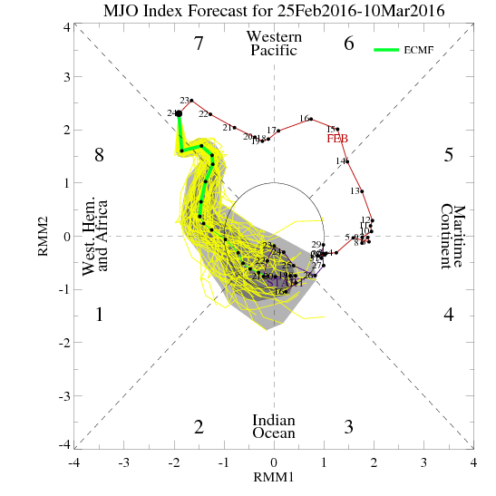
+MT/+AAM jet extension with MJO phase 8/dateline standing wave constructive interference and stratospheric vortex destruction post March 5-6th with full trop-strat coupling should yield the tropospheric geopotential height response in the high latitudes. I know folks are skeptical regarding the -NAO, and rightfully so, but again, the indicators we see going forward have largely not been seen over this winter. We'll see I guess. February didn't really produce to anyone's expectations, but it still appears that a favorable late season Nino pattern may occur.
The MJO enters phase 8 on February 29th, so approximately 7 days later we should expect the downstream response, putting us in the March 6th+ period [which agrees with stratospheric progression].

Isotherm- Advanced Forecaster
- Posts : 231
Reputation : 4
Join date : 2014-09-01
Age : 33
Location : Monmouth County, NJ -
Re: Long Range Thread 11.0
![]() by Isotherm Thu Feb 25, 2016 1:08 pm
by Isotherm Thu Feb 25, 2016 1:08 pm
I agree re blizzard causation. Trop kara ridge--> strat perturbation --> - AO plunge.
Isotherm- Advanced Forecaster
- Posts : 231
Reputation : 4
Join date : 2014-09-01
Age : 33
Location : Monmouth County, NJ -
Re: Long Range Thread 11.0
![]() by Frank_Wx Thu Feb 25, 2016 1:23 pm
by Frank_Wx Thu Feb 25, 2016 1:23 pm
Here is the next displacement taking place between now and March 5th. As Tom said, after the 5th-6th period we should see the Troposphere respond to this next warming event.


Today's 12z GEFS look enticing after the 5th. The Arctic is beginning to look pretty warm with a pinched off ridge north of Alaska and a possible -NAO forming. The NPAC trough is far enough west to keep the ridge pumping over the western US.

What's going to be key with this forecast is not exactly the NAO - I do think it'll go negative - but probably the Pacific. If the Aleutian Low moves too close to the west coast it will shun the ridge east and destroy our chance of a sustained cold pattern.

The MJO going into a favorable phase should hopefully keep the trough west near the Aleutians. The GEFS also have a progressive bias. Much better look in the LR today. I'm happy.
_________________
_______________________________________________________________________________________________________
CLICK HERE to view NJ Strong Snowstorm Classifications
Frank_Wx- Godzilla Seeker
- Posts : 21305
Reputation : 328
Join date : 2013-01-05
Age : 31
Location : Jersey City, NJ -
Re: Long Range Thread 11.0
![]() by algae888 Thu Feb 25, 2016 4:27 pm
by algae888 Thu Feb 25, 2016 4:27 pm


algae888- Advanced Forecaster
- Posts : 5311
Reputation : 46
Join date : 2013-02-05
Age : 61
Location : mt. vernon, new york
Re: Long Range Thread 11.0
![]() by amugs Thu Feb 25, 2016 5:06 pm
by amugs Thu Feb 25, 2016 5:06 pm
_________________
Mugs
AKA:King: Snow Weenie
Self Proclaimed
WINTER 2014-15 : 55.12" +.02 for 6 coatings (avg. 35")
WINTER 2015-16 Total - 29.8" (Avg 35")
WINTER 2016-17 : 39.5" so far

amugs- Advanced Forecaster - Mod

- Posts : 15091
Reputation : 213
Join date : 2013-01-07
Age : 54
Location : Hillsdale,NJ
Re: Long Range Thread 11.0
![]() by NjWeatherGuy Thu Feb 25, 2016 5:08 pm
by NjWeatherGuy Thu Feb 25, 2016 5:08 pm

NjWeatherGuy- Advanced Forecaster
- Posts : 4100
Reputation : 28
Join date : 2013-01-06
Location : Belle Mead, NJ
Re: Long Range Thread 11.0
![]() by Frank_Wx Thu Feb 25, 2016 5:39 pm
by Frank_Wx Thu Feb 25, 2016 5:39 pm

_________________
_______________________________________________________________________________________________________
CLICK HERE to view NJ Strong Snowstorm Classifications
Frank_Wx- Godzilla Seeker
- Posts : 21305
Reputation : 328
Join date : 2013-01-05
Age : 31
Location : Jersey City, NJ -
Re: Long Range Thread 11.0
![]() by Frank_Wx Thu Feb 25, 2016 5:42 pm
by Frank_Wx Thu Feb 25, 2016 5:42 pm

Also needs the HP to the north to be further south

_________________
_______________________________________________________________________________________________________
CLICK HERE to view NJ Strong Snowstorm Classifications
Frank_Wx- Godzilla Seeker
- Posts : 21305
Reputation : 328
Join date : 2013-01-05
Age : 31
Location : Jersey City, NJ -
Re: Long Range Thread 11.0
![]() by Frank_Wx Thu Feb 25, 2016 5:55 pm
by Frank_Wx Thu Feb 25, 2016 5:55 pm

_________________
_______________________________________________________________________________________________________
CLICK HERE to view NJ Strong Snowstorm Classifications
Frank_Wx- Godzilla Seeker
- Posts : 21305
Reputation : 328
Join date : 2013-01-05
Age : 31
Location : Jersey City, NJ -
Re: Long Range Thread 11.0
![]() by amugs Thu Feb 25, 2016 6:40 pm
by amugs Thu Feb 25, 2016 6:40 pm
holy Hannah that us less than 10 days away could.it be? Finally. I posted this last week that it showed the same wow we have some consistent modelling here. IF this is being depicted by Monday then blow me down Popeye!!!Frank_Wx wrote:12z gefs split the PV at 10hPa today.
_________________
Mugs
AKA:King: Snow Weenie
Self Proclaimed
WINTER 2014-15 : 55.12" +.02 for 6 coatings (avg. 35")
WINTER 2015-16 Total - 29.8" (Avg 35")
WINTER 2016-17 : 39.5" so far
amugs- Advanced Forecaster - Mod
- Posts : 15091
Reputation : 213
Join date : 2013-01-07
Age : 54
Location : Hillsdale,NJ
Re: Long Range Thread 11.0
![]() by algae888 Thu Feb 25, 2016 7:36 pm
by algae888 Thu Feb 25, 2016 7:36 pm


algae888- Advanced Forecaster
- Posts : 5311
Reputation : 46
Join date : 2013-02-05
Age : 61
Location : mt. vernon, new york
Re: Long Range Thread 11.0
![]() by CPcantmeasuresnow Thu Feb 25, 2016 7:46 pm
by CPcantmeasuresnow Thu Feb 25, 2016 7:46 pm

CPcantmeasuresnow- Wx Statistician Guru

- Posts : 7274
Reputation : 230
Join date : 2013-01-07
Age : 103
Location : Eastern Orange County, NY
Re: Long Range Thread 11.0
![]() by algae888 Thu Feb 25, 2016 7:58 pm
by algae888 Thu Feb 25, 2016 7:58 pm
cp I believe there are a couple of factors. one is the western atlantic ridge which has been unusually strong this year and it is preventing storms from moving due east. if the hp to the north is weaker than the WAR then the low will move towards the path of least resistance. also if the low is wound up and strong west of the Mississippi then it would be steered northward as that would raise heights off the east coast and strengthen the WAR. so we need a weaker system as it moves through the central US and a weaker WAR. still time with this one. plenty of s/w in the flow. I believe one of these are going to trend good for us.CPcantmeasuresnow wrote:There's a very nice High parked in a good spot over Ontario on most of these runs. I'm not sure why this thing has been cutting on many models considering where that high is positioned, but when it comes to this stuff I barely know the basics.
algae888- Advanced Forecaster
- Posts : 5311
Reputation : 46
Join date : 2013-02-05
Age : 61
Location : mt. vernon, new york
Re: Long Range Thread 11.0
![]() by rb924119 Thu Feb 25, 2016 8:22 pm
by rb924119 Thu Feb 25, 2016 8:22 pm
amugs wrote:Scott,
Thank you for correcting my error on the Strat - I meant it as yuo explained but wrote in in between classes!
To the question of the PV - I would love to hear or see something that explains this beast.
Excellent discussion here and where is Ray to chime in?
I am also perplexed on the MJO from his study in the fall on the MJO in nino years for it being in the mean of phases 8,1,2 - dam IO!!!
I've been here; just lurking haha I've been busy with work, first off, and secondly, I honestly can't add anything to your discussion. You guys have hit every topic deeply and accurately. Why mess with perfection? lol
rb924119- Meteorologist

- Posts : 6888
Reputation : 194
Join date : 2013-02-06
Age : 32
Location : Greentown, Pa
Snow88- Senior Enthusiast
- Posts : 2193
Reputation : 4
Join date : 2013-01-09
Age : 35
Location : Brooklyn, NY
Re: Long Range Thread 11.0
![]() by Snow88 Thu Feb 25, 2016 11:09 pm
by Snow88 Thu Feb 25, 2016 11:09 pm
Snow88- Senior Enthusiast
- Posts : 2193
Reputation : 4
Join date : 2013-01-09
Age : 35
Location : Brooklyn, NY
Re: Long Range Thread 11.0
![]() by hyde345 Thu Feb 25, 2016 11:29 pm
by hyde345 Thu Feb 25, 2016 11:29 pm

hyde345- Pro Enthusiast

- Posts : 1082
Reputation : 48
Join date : 2013-01-08
Location : Hyde Park, NY
Re: Long Range Thread 11.0
![]() by Snow88 Thu Feb 25, 2016 11:41 pm
by Snow88 Thu Feb 25, 2016 11:41 pm
Snow88- Senior Enthusiast
- Posts : 2193
Reputation : 4
Join date : 2013-01-09
Age : 35
Location : Brooklyn, NY
Page 2 of 27 • 1, 2, 3 ... 14 ... 27 ![]()
|
|
|