
 Search
August 2013 Observation & Discussions Thread
Page 1 of 3 • 1, 2, 3 ![]()

August 2013 Observation & Discussions Thread
![]() by Frank_Wx Thu Aug 01, 2013 10:30 am
by Frank_Wx Thu Aug 01, 2013 10:30 am
Last edited by Frank_Wx on Sat Aug 31, 2013 8:53 pm; edited 1 time in total

Frank_Wx- Godzilla Seeker

- Posts : 21305
Reputation : 328
Join date : 2013-01-05
Age : 31
Location : Jersey City, NJ -

Re: August 2013 Observation & Discussions Thread
![]() by Quietace Thu Aug 01, 2013 5:52 pm
by Quietace Thu Aug 01, 2013 5:52 pm


And the GFS at the end of its run want to keep the ridging to the west with a trough in the east past mid month continually displacing the Bermuda high far east. We will see if the pattern holds true and keeps it displaced west past mid month or if it will have a chance to rebuild back into the area if the persistent troughs weaken a bit, which is a possibility.


Quietace- Meteorologist - Mod

- Posts : 3687
Reputation : 33
Join date : 2013-01-07
Age : 27
Location : Point Pleasant, NJ
Re: August 2013 Observation & Discussions Thread
![]() by Frank_Wx Thu Aug 01, 2013 11:48 pm
by Frank_Wx Thu Aug 01, 2013 11:48 pm
Frank_Wx- Godzilla Seeker
- Posts : 21305
Reputation : 328
Join date : 2013-01-05
Age : 31
Location : Jersey City, NJ -
Re: August 2013 Observation & Discussions Thread
![]() by Frank_Wx Fri Aug 02, 2013 1:11 am
by Frank_Wx Fri Aug 02, 2013 1:11 am
http://njstrongweather.blogspot.com/2013/08/exactly-how-cool-will-it-get.html
Frank_Wx- Godzilla Seeker
- Posts : 21305
Reputation : 328
Join date : 2013-01-05
Age : 31
Location : Jersey City, NJ -
Re: August 2013 Observation & Discussions Thread
![]() by HeresL Sat Aug 03, 2013 8:39 am
by HeresL Sat Aug 03, 2013 8:39 am

HeresL- Posts : 122
Reputation : 0
Join date : 2013-01-20
Location : West Milford, NJ
Re: August 2013 Observation & Discussions Thread
![]() by Frank_Wx Mon Aug 05, 2013 9:25 am
by Frank_Wx Mon Aug 05, 2013 9:25 am
Frank_Wx- Godzilla Seeker
- Posts : 21305
Reputation : 328
Join date : 2013-01-05
Age : 31
Location : Jersey City, NJ -
Re: August 2013 Observation & Discussions Thread
![]() by Quietace Wed Aug 07, 2013 8:38 pm
by Quietace Wed Aug 07, 2013 8:38 pm
The GEM has a 594 DM high popping a strong + PNA ridge in the west. You can also notice the HP center is further west itself. This allows the Upper Level Vort over Canada to react and form a sharper and stronger vort with tighter pressure gradients over the Eastern US and Build a strong 1023mb high on the back side of the trough

With the tight trough over the Eastern US with a strong Vort Max over Canada it allows even cooler air to filter in behind the departing ULL bringing much below average 850's and in turn temperatures.

The GFS on the other hand has a much weaker Hp is the SW that is displaced further east due to the GFS's accelerated movement of the ULL. With out the HP being further west and in a more stronger and dominating position, it is unable to form a more vertically oriented Positive ridge in the west, therefore not allowing the ULL to dive further south and enhance the trough, making the pattern in the Eastern US more zonal than the GEM.
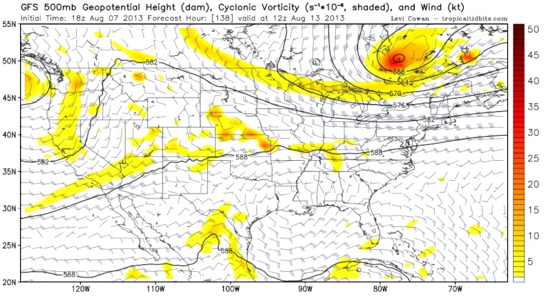
At 150 hours you can easy see the difference between the GFS and GEM, the GFS has the ULL much father to the east than the GEM, and a almost complete zonal pattern with little vertical tilt to the Jet stream. this allows more seasonable temperatures to stay in the area with a west wind rather than a cool NW or N wind and allowing the bulk of the cooler weather to the west.


Their has been a trend to a weaker trough in the east in this time period over the last day or two. If this trend continues we will not see much below average temps, but if the global guidance holds suite we could be in for a even more pronounced cool down. We will see how models trened the next couple days.
Quietace- Meteorologist - Mod
- Posts : 3687
Reputation : 33
Join date : 2013-01-07
Age : 27
Location : Point Pleasant, NJ
Re: August 2013 Observation & Discussions Thread
![]() by Frank_Wx Wed Aug 07, 2013 9:37 pm
by Frank_Wx Wed Aug 07, 2013 9:37 pm
Frank_Wx- Godzilla Seeker
- Posts : 21305
Reputation : 328
Join date : 2013-01-05
Age : 31
Location : Jersey City, NJ -
Re: August 2013 Observation & Discussions Thread
![]() by Frank_Wx Thu Aug 08, 2013 7:09 pm
by Frank_Wx Thu Aug 08, 2013 7:09 pm
Frank_Wx- Godzilla Seeker
- Posts : 21305
Reputation : 328
Join date : 2013-01-05
Age : 31
Location : Jersey City, NJ -
Re: August 2013 Observation & Discussions Thread
![]() by Frank_Wx Thu Aug 08, 2013 7:19 pm
by Frank_Wx Thu Aug 08, 2013 7:19 pm
I would have to say 1-2+ inches of rain instead of only 1 inch. Especially in localized areas who keep seeing t-storms.Frank_Wx wrote:Wednesday-Friday of this week could bring moderate rain at times. Looks pretty unsettled. I would bet atleaat 1.00 inches of rain likely.
Frank_Wx- Godzilla Seeker
- Posts : 21305
Reputation : 328
Join date : 2013-01-05
Age : 31
Location : Jersey City, NJ -
Re: August 2013 Observation & Discussions Thread
![]() by Dunnzoo Sat Aug 10, 2013 9:46 am
by Dunnzoo Sat Aug 10, 2013 9:46 am
_________________
Janet
Snowfall winter of 2023-2024 17.5"
Snowfall winter of 2022-2023 6.0"
Snowfall winter of 2021-2022 17.6" 1" sleet 2/25/22
Snowfall winter of 2020-2021 51.1"
Snowfall winter of 2019-2020 8.5"
Snowfall winter of 2018-2019 25.1"
Snowfall winter of 2017-2018 51.9"
Snowfall winter of 2016-2017 45.6"
Snowfall winter of 2015-2016 29.5"
Snowfall winter of 2014-2015 50.55"
Snowfall winter of 2013-2014 66.5"

Dunnzoo- Senior Enthusiast - Mod

- Posts : 4882
Reputation : 68
Join date : 2013-01-11
Age : 62
Location : Westwood, NJ
Re: August 2013 Observation & Discussions Thread
![]() by Frank_Wx Sat Aug 10, 2013 2:34 pm
by Frank_Wx Sat Aug 10, 2013 2:34 pm
Frank_Wx- Godzilla Seeker
- Posts : 21305
Reputation : 328
Join date : 2013-01-05
Age : 31
Location : Jersey City, NJ -
Re: August 2013 Observation & Discussions Thread
![]() by Quietace Sat Aug 10, 2013 4:13 pm
by Quietace Sat Aug 10, 2013 4:13 pm
Well considering we have had...no severe weather....no hurricanes....no heat waves.... and barley any rain......i guess looking at temperature forecasts and sun angles are now considered fun......lol...maybe its time for a very preliminary winter forecast to be in the works...i mean there is nothing else to do....Frank_Wx wrote:This has been a really boring month, eh?
Quietace- Meteorologist - Mod
- Posts : 3687
Reputation : 33
Join date : 2013-01-07
Age : 27
Location : Point Pleasant, NJ
Re: August 2013 Observation & Discussions Thread
![]() by Dunnzoo Sat Aug 10, 2013 6:14 pm
by Dunnzoo Sat Aug 10, 2013 6:14 pm
_________________
Janet
Snowfall winter of 2023-2024 17.5"
Snowfall winter of 2022-2023 6.0"
Snowfall winter of 2021-2022 17.6" 1" sleet 2/25/22
Snowfall winter of 2020-2021 51.1"
Snowfall winter of 2019-2020 8.5"
Snowfall winter of 2018-2019 25.1"
Snowfall winter of 2017-2018 51.9"
Snowfall winter of 2016-2017 45.6"
Snowfall winter of 2015-2016 29.5"
Snowfall winter of 2014-2015 50.55"
Snowfall winter of 2013-2014 66.5"
Dunnzoo- Senior Enthusiast - Mod
- Posts : 4882
Reputation : 68
Join date : 2013-01-11
Age : 62
Location : Westwood, NJ
Re: August 2013 Observation & Discussions Thread
![]() by Quietace Sat Aug 10, 2013 6:28 pm
by Quietace Sat Aug 10, 2013 6:28 pm
Don't count on it, some models are hinting that the Bermuda high might have a chance to retrograde back west by the end of August with warm and humid above average temperatures. But we dont have to much model support yet so its preliminary.Dunnzoo wrote:I'm looking at temps for the next few weeks since I will be vacationing in Seaside Park starting the 17th until Labor Day. Would love for these moderate temps to stick around for the rest of the month. So far I see no 90's at the shore for the next 2 weeks!
Quietace- Meteorologist - Mod
- Posts : 3687
Reputation : 33
Join date : 2013-01-07
Age : 27
Location : Point Pleasant, NJ
Re: August 2013 Observation & Discussions Thread
![]() by Frank_Wx Mon Aug 12, 2013 8:33 am
by Frank_Wx Mon Aug 12, 2013 8:33 am
Frank_Wx- Godzilla Seeker
- Posts : 21305
Reputation : 328
Join date : 2013-01-05
Age : 31
Location : Jersey City, NJ -
Re: August 2013 Observation & Discussions Thread
![]() by Frank_Wx Mon Aug 12, 2013 11:29 pm
by Frank_Wx Mon Aug 12, 2013 11:29 pm
Frank_Wx- Godzilla Seeker
- Posts : 21305
Reputation : 328
Join date : 2013-01-05
Age : 31
Location : Jersey City, NJ -
Re: August 2013 Observation & Discussions Thread
![]() by Snow88 Wed Aug 14, 2013 1:58 am
by Snow88 Wed Aug 14, 2013 1:58 am

Snow88- Senior Enthusiast

- Posts : 2193
Reputation : 4
Join date : 2013-01-09
Age : 35
Location : Brooklyn, NY
Re: August 2013 Observation & Discussions Thread
![]() by Frank_Wx Thu Aug 15, 2013 6:01 pm
by Frank_Wx Thu Aug 15, 2013 6:01 pm
Frank_Wx- Godzilla Seeker
- Posts : 21305
Reputation : 328
Join date : 2013-01-05
Age : 31
Location : Jersey City, NJ -
Re: August 2013 Observation & Discussions Thread
![]() by Quietace Fri Aug 16, 2013 3:09 pm
by Quietace Fri Aug 16, 2013 3:09 pm
Quietace- Meteorologist - Mod
- Posts : 3687
Reputation : 33
Join date : 2013-01-07
Age : 27
Location : Point Pleasant, NJ
Re: August 2013 Observation & Discussions Thread
![]() by Quietace Fri Aug 16, 2013 9:06 pm
by Quietace Fri Aug 16, 2013 9:06 pm


Courtesy to Weather Bell....
Quietace- Meteorologist - Mod
- Posts : 3687
Reputation : 33
Join date : 2013-01-07
Age : 27
Location : Point Pleasant, NJ
Re: August 2013 Observation & Discussions Thread
![]() by Frank_Wx Fri Aug 16, 2013 9:16 pm
by Frank_Wx Fri Aug 16, 2013 9:16 pm
Frank_Wx- Godzilla Seeker
- Posts : 21305
Reputation : 328
Join date : 2013-01-05
Age : 31
Location : Jersey City, NJ -
Re: August 2013 Observation & Discussions Thread
![]() by Quietace Sat Aug 17, 2013 7:07 am
by Quietace Sat Aug 17, 2013 7:07 am


lol, look at the blocking and serious -NAO it wants to develop in September, just enhances the probability of cool weather.
And the EURO flipped with the GFS last night, the EURO brings abut 1.5 inches of rain for southern Coastal NJ, while GFS has almost nothing. NYC stays dry with either solution with just heavy cloud cover.
Quietace- Meteorologist - Mod
- Posts : 3687
Reputation : 33
Join date : 2013-01-07
Age : 27
Location : Point Pleasant, NJ
Re: August 2013 Observation & Discussions Thread
![]() by Frank_Wx Sat Aug 17, 2013 12:49 pm
by Frank_Wx Sat Aug 17, 2013 12:49 pm
Frank_Wx- Godzilla Seeker
- Posts : 21305
Reputation : 328
Join date : 2013-01-05
Age : 31
Location : Jersey City, NJ -
Re: August 2013 Observation & Discussions Thread
![]() by Quietace Sat Aug 17, 2013 1:06 pm
by Quietace Sat Aug 17, 2013 1:06 pm

Quietace- Meteorologist - Mod
- Posts : 3687
Reputation : 33
Join date : 2013-01-07
Age : 27
Location : Point Pleasant, NJ
Page 1 of 3 • 1, 2, 3 ![]()
|
|
|