
 Search
Long Range Thread 13.0
Page 23 of 40 •  1 ... 13 ... 22, 23, 24 ... 31 ... 40
 ![]()
Re: Long Range Thread 13.0
![]() by track17 Sun Jan 08, 2017 9:36 am
by track17 Sun Jan 08, 2017 9:36 am
track17- Posts : 454
Join date : 2016-01-09
Re: Long Range Thread 13.0
![]() by skinsfan1177 Sun Jan 08, 2017 10:03 am
by skinsfan1177 Sun Jan 08, 2017 10:03 am
skinsfan1177- Senior Enthusiast

- Posts : 4485
Join date : 2013-01-07
Re: Long Range Thread 13.0
![]() by rb924119 Sun Jan 08, 2017 10:11 am
by rb924119 Sun Jan 08, 2017 10:11 am
rb924119- Meteorologist

- Posts : 6888
Reputation : 194
Join date : 2013-02-06
Age : 32
Location : Greentown, Pa
Re: Long Range Thread 13.0
![]() by jake732 Sun Jan 08, 2017 10:39 am
by jake732 Sun Jan 08, 2017 10:39 am

jake732- Pro Enthusiast

- Posts : 449
Reputation : 0
Join date : 2016-01-03
Location : lakewood, nj -

Re: Long Range Thread 13.0
![]() by skinsfan1177 Sun Jan 08, 2017 10:57 am
by skinsfan1177 Sun Jan 08, 2017 10:57 am

skinsfan1177- Senior Enthusiast
- Posts : 4485
Reputation : 35
Join date : 2013-01-07
Age : 46
Location : Point Pleasant Boro
Re: Long Range Thread 13.0
![]() by skinsfan1177 Sun Jan 08, 2017 11:01 am
by skinsfan1177 Sun Jan 08, 2017 11:01 am
Now it all depends on getting on the right side of boundary. And if those Hs are in place
skinsfan1177- Senior Enthusiast
- Posts : 4485
Reputation : 35
Join date : 2013-01-07
Age : 46
Location : Point Pleasant Boro
Re: Long Range Thread 13.0
![]() by SoulSingMG Sun Jan 08, 2017 11:09 am
by SoulSingMG Sun Jan 08, 2017 11:09 am
rb924119 wrote:REALLY getting fired up about the next 12-14 day period. Upon further inspection, I am seeing THREE chances for white gold. Things could be very interesting for us!! Video to come (hopefully) by the end of today.
You're never this excited! Can't wait to see the video


SoulSingMG- Senior Enthusiast
- Posts : 2853
Reputation : 74
Join date : 2013-12-11
Location : Long Island City, NY
Re: Long Range Thread 13.0
![]() by jake732 Sun Jan 08, 2017 11:13 am
by jake732 Sun Jan 08, 2017 11:13 am
jake732- Pro Enthusiast
- Posts : 449
Reputation : 0
Join date : 2016-01-03
Location : lakewood, nj -
Re: Long Range Thread 13.0
![]() by skinsfan1177 Sun Jan 08, 2017 11:40 am
by skinsfan1177 Sun Jan 08, 2017 11:40 am
jake732 wrote:to many sleepless nights to track a rain storm....if if if everything goes right then it can snow.
Jake your optimism is some4himg else. You where thinking nothing for this storm and we got 8 inches . it's a week away tracking is fun either way
skinsfan1177- Senior Enthusiast
- Posts : 4485
Reputation : 35
Join date : 2013-01-07
Age : 46
Location : Point Pleasant Boro
Re: Long Range Thread 13.0
![]() by jake732 Sun Jan 08, 2017 11:42 am
by jake732 Sun Jan 08, 2017 11:42 am
skinsfan1177 wrote:jake732 wrote:to many sleepless nights to track a rain storm....if if if everything goes right then it can snow.
Jake your optimism is some4himg else. You where thinking nothing for this storm and we got 8 inches . it's a week away tracking is fun either way
deep deep down i though we would get hit and we did.
jake732- Pro Enthusiast
- Posts : 449
Reputation : 0
Join date : 2016-01-03
Location : lakewood, nj -
Re: Long Range Thread 13.0
![]() by jmanley32 Sun Jan 08, 2017 12:05 pm
by jmanley32 Sun Jan 08, 2017 12:05 pm
Did ya see the snow map holy god, its not a godzilla its a roidzilla! Verbatim that is and it IS the CMC. I'll post the snow map in banter.skinsfan1177 wrote:
Now it all depends on getting on the right side of boundary. And if those Hs are in place

jmanley32- Senior Enthusiast
- Posts : 20512
Reputation : 108
Join date : 2013-12-12
Age : 42
Location : Yonkers, NY
Re: Long Range Thread 13.0
![]() by CPcantmeasuresnow Sun Jan 08, 2017 12:07 pm
by CPcantmeasuresnow Sun Jan 08, 2017 12:07 pm
jmanley32 wrote:Did ya see the snow map holy god, its not a godzilla its a roidzilla! Verbatim that is and it IS the CMC. I'll post the snow map in banter.skinsfan1177 wrote:
Now it all depends on getting on the right side of boundary. And if those Hs are in place
Come on Jman post it

CPcantmeasuresnow- Wx Statistician Guru

- Posts : 7274
Reputation : 230
Join date : 2013-01-07
Age : 103
Location : Eastern Orange County, NY
Re: Long Range Thread 13.0
![]() by algae888 Sun Jan 08, 2017 1:28 pm
by algae888 Sun Jan 08, 2017 1:28 pm

algae888- Advanced Forecaster

- Posts : 5311
Reputation : 46
Join date : 2013-02-05
Age : 61
Location : mt. vernon, new york
Re: Long Range Thread 13.0
![]() by algae888 Sun Jan 08, 2017 1:38 pm
by algae888 Sun Jan 08, 2017 1:38 pm

with strong hp in that position in mid jan the 540 line would usually be in the Carolina with suppression for our area.

however look at the /se ridge on the euro ensembles. that would set up a very strong gradient near us. s/e ridge can at times be our friend. all comes down to timing. so as scott says we track.! fun winter for me so far!
edit also note the very blocky pattern in the atlantic. fun times ahead
algae888- Advanced Forecaster
- Posts : 5311
Reputation : 46
Join date : 2013-02-05
Age : 61
Location : mt. vernon, new york
Re: Long Range Thread 13.0
![]() by Frank_Wx Sun Jan 08, 2017 7:19 pm
by Frank_Wx Sun Jan 08, 2017 7:19 pm
_________________
_______________________________________________________________________________________________________
CLICK HERE to view NJ Strong Snowstorm Classifications

Frank_Wx- Godzilla Seeker

- Posts : 21305
Reputation : 328
Join date : 2013-01-05
Age : 31
Location : Jersey City, NJ -
Re: Long Range Thread 13.0
![]() by Math23x7 Mon Jan 09, 2017 12:11 am
by Math23x7 Mon Jan 09, 2017 12:11 am
Math23x7- Wx Statistician Guru
- Posts : 2379
Reputation : 68
Join date : 2013-01-08
Re: Long Range Thread 13.0
![]() by docstox12 Mon Jan 09, 2017 2:01 am
by docstox12 Mon Jan 09, 2017 2:01 am

docstox12- Wx Statistician Guru
- Posts : 8497
Reputation : 222
Join date : 2013-01-07
Age : 73
Location : Monroe NY
Re: Long Range Thread 13.0
![]() by sroc4 Mon Jan 09, 2017 7:27 am
by sroc4 Mon Jan 09, 2017 7:27 am
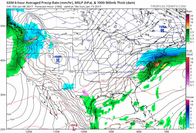
How Long Will The January Thaw Last? And What Will Follow?
From looking at the computer model and analog forecasts, it seems pretty certain that something approximating the "January Thaw" will be affecting most of the nation between January 13 and 22. But the question many forecasters have on their minds is, "Is winter over"? If you look at past history of the season so far, the volatile pattern swings back and forth between intense cold snaps and bizarre warm-up, with the tendency for the milder air to establish its presence over the southern and eastern tiers of the nation. This alignment has been repeated in the first week of January. So right off the bat we can say that any major surges of warmth have a tendency to be pushed out by portions of the vast cold air field across Canada, aided and abetted by the impressive snowpack that is touching the Gulf Coast at this time.
Keep in mind that I do not expect that snow cover to stay in the Deep South. The ice and snow field may actually recede into the far northern tier of the country to the right of the Continental Divide during the middle of the month. But here, climatology and the analogs point out that the southern branch wind field will work its magic, likely setting up a broad storm near Baja California by the end of the third week of the month. This is not a La Nina winter; rather, this is a negative/neutral ENSO signal that has sometimes displayed tendencies like an El Nino, with an impressive subtropical jet stream. If the ECMWF and GFS series are correct with energy from the northern jet stream digging through the Intermountain Region and phasing with the lower latitude wind maximum, the resultant cyclone will roll through Texas and into the lower Great Lakes around January 22 - 24. Such a track, of course, would pull the mean 500MB trough yet again into the Great Plains and Mississippi Valley. Cold air drainage into the western 2/3 of the nation would surely follow.
But a potentially new rub shows up in the weekly forecasts of the CFS and ECMWF platforms: strong -EPO/+PNA ridging from Alaska to California. The analog depiction seems a little fast with this development (January 22), but I am confident that a warm/dry West vs. cold/stormy Central East configuration is likely to occur shortly thereafter, and quite possibly last through February and the first half of March. The 1996 comparison has some value here, albeit with a colder outcome like 2014 or 2015. If dual blocking signatures emerge again along the entire Pacific shoreline and Greenland, the most recent Arctic intrusion will seem like just "part of the pattern" of the winter of 2016-2017.
With some more eastern U.S. snow and ice events thrown into the mix, just for fun.
Last edited by sroc4 on Mon Jan 09, 2017 7:59 am; edited 1 time in total
_________________
"In weather and in life, there's no winning and losing; there's only winning and learning."
WINTER 2012/2013 TOTALS 43.65"WINTER 2017/2018 TOTALS 62.85" WINTER 2022/2023 TOTALS 4.9"
WINTER 2013/2014 TOTALS 64.85"WINTER 2018/2019 TOTALS 14.25" WINTER 2023/2024 TOTALS 13.1"
WINTER 2014/2015 TOTALS 71.20"WINTER 2019/2020 TOTALS 6.35"
WINTER 2015/2016 TOTALS 35.00"WINTER 2020/2021 TOTALS 37.75"
WINTER 2016/2017 TOTALS 42.25"WINTER 2021/2022 TOTALS 31.65"

sroc4- Admin
- Posts : 8331
Reputation : 301
Join date : 2013-01-07
Location : Wading River, LI
Re: Long Range Thread 13.0
![]() by sroc4 Mon Jan 09, 2017 7:40 am
by sroc4 Mon Jan 09, 2017 7:40 am
_________________
"In weather and in life, there's no winning and losing; there's only winning and learning."
WINTER 2012/2013 TOTALS 43.65"WINTER 2017/2018 TOTALS 62.85" WINTER 2022/2023 TOTALS 4.9"
WINTER 2013/2014 TOTALS 64.85"WINTER 2018/2019 TOTALS 14.25" WINTER 2023/2024 TOTALS 13.1"
WINTER 2014/2015 TOTALS 71.20"WINTER 2019/2020 TOTALS 6.35"
WINTER 2015/2016 TOTALS 35.00"WINTER 2020/2021 TOTALS 37.75"
WINTER 2016/2017 TOTALS 42.25"WINTER 2021/2022 TOTALS 31.65"
sroc4- Admin
- Posts : 8331
Reputation : 301
Join date : 2013-01-07
Location : Wading River, LI
Re: Long Range Thread 13.0
![]() by sroc4 Mon Jan 09, 2017 7:56 am
by sroc4 Mon Jan 09, 2017 7:56 am
https://www.longpaddock.qld.gov.au/seasonalclimateoutlook/southernoscillationindex/30daysoivalues/
However, beyond 48hrs it should come back down towards neutral territory, and there is some evidence that by the end of the week we could see a significant crash of the SOI as it appears that there will be HP building over Darwin Australia and pressures lower around Tahiti. The MJO forecasts correlate nicely with the SOI spike as it is coming out in phases 5 and 6; however if the Md range MJO forecasts are correct they could be hinting at coming out in phase 1. That said, and this has been said many times thus far this winter season, the Md and LR MJO forecasts have been deplorable at best. IF we get a significant enough SOI crash , on the order of -15 to -20 or lower for a few days, expect a favorable MJO pulse, the result of which would likely lead to a trough and potentially a snow threat about 5-7days later. Keep in mind; however, that the possibility of an SOI crash exists, but doesn't mean it is guaranteed. LR forecast to the Darwin Tahiti regions of course can change just like in our back yards.


Last edited by sroc4 on Tue Jan 10, 2017 12:32 pm; edited 1 time in total
_________________
"In weather and in life, there's no winning and losing; there's only winning and learning."
WINTER 2012/2013 TOTALS 43.65"WINTER 2017/2018 TOTALS 62.85" WINTER 2022/2023 TOTALS 4.9"
WINTER 2013/2014 TOTALS 64.85"WINTER 2018/2019 TOTALS 14.25" WINTER 2023/2024 TOTALS 13.1"
WINTER 2014/2015 TOTALS 71.20"WINTER 2019/2020 TOTALS 6.35"
WINTER 2015/2016 TOTALS 35.00"WINTER 2020/2021 TOTALS 37.75"
WINTER 2016/2017 TOTALS 42.25"WINTER 2021/2022 TOTALS 31.65"
sroc4- Admin
- Posts : 8331
Reputation : 301
Join date : 2013-01-07
Location : Wading River, LI
Re: Long Range Thread 13.0
![]() by Guest Mon Jan 09, 2017 8:12 am
by Guest Mon Jan 09, 2017 8:12 am
Guest- Guest
Re: Long Range Thread 13.0
![]() by CPcantmeasuresnow Mon Jan 09, 2017 8:19 am
by CPcantmeasuresnow Mon Jan 09, 2017 8:19 am
syosnow94 wrote:I know this Cosgrove guy is a highly educated Met, but any mention comparing this winter over our area to 1996 is OUTRAGEOUS IMHO!! We had 17 snow events of 3" or more that year.
In fairness what he's saying is late January through Mid March could be similar. 1995/96 had snow from November through April so I get your point.
95/96 was also the only year to my knowledge that LI recorded 5 consecutive months of 10 inches or more of snow which happened in December 1995 and Jan, Feb, Mar and April of 1996. They also had a couple of storm in November 1995 but didn't reach 10 inches that month or it would have been 6.
CPcantmeasuresnow- Wx Statistician Guru
- Posts : 7274
Reputation : 230
Join date : 2013-01-07
Age : 103
Location : Eastern Orange County, NY
Re: Long Range Thread 13.0
![]() by Guest Mon Jan 09, 2017 8:28 am
by Guest Mon Jan 09, 2017 8:28 am
Guest- Guest
Re: Long Range Thread 13.0
![]() by sroc4 Mon Jan 09, 2017 8:49 am
by sroc4 Mon Jan 09, 2017 8:49 am
_________________
"In weather and in life, there's no winning and losing; there's only winning and learning."
WINTER 2012/2013 TOTALS 43.65"WINTER 2017/2018 TOTALS 62.85" WINTER 2022/2023 TOTALS 4.9"
WINTER 2013/2014 TOTALS 64.85"WINTER 2018/2019 TOTALS 14.25" WINTER 2023/2024 TOTALS 13.1"
WINTER 2014/2015 TOTALS 71.20"WINTER 2019/2020 TOTALS 6.35"
WINTER 2015/2016 TOTALS 35.00"WINTER 2020/2021 TOTALS 37.75"
WINTER 2016/2017 TOTALS 42.25"WINTER 2021/2022 TOTALS 31.65"
sroc4- Admin
- Posts : 8331
Reputation : 301
Join date : 2013-01-07
Location : Wading River, LI
Re: Long Range Thread 13.0
![]() by docstox12 Mon Jan 09, 2017 9:04 am
by docstox12 Mon Jan 09, 2017 9:04 am
docstox12- Wx Statistician Guru
- Posts : 8497
Reputation : 222
Join date : 2013-01-07
Age : 73
Location : Monroe NY
Re: Long Range Thread 13.0
![]() by amugs Mon Jan 09, 2017 9:23 am
by amugs Mon Jan 09, 2017 9:23 am
Take the stratosphere and soi and the grease truck along with all this - their is terrestrial (planetary) alignment configuration that will make February rock an dit i son course - unless in the next 10 days something goes awry. URANUS (no ones on this forum) is going to align at 60* with earths perigee and cause us to go into the freezer for February usually lasting about 20 - 25 days from my research after hearing Jim Witt talk about this. Time frame he said is late January through later February. His analog comparisons - and Jim dont take this literally, you will blow a gasket or two by doing so it is just as Scott said for comparison sakes:
Years of analog:
1917-18
1947-48
1977-78
1993-94
2014-15
Unusual to have this planetary pattern so close from recorded data.
He is calling for 8* BN for NYC & 8" AN in snowfall for NYC and the NYC metro, HV and Mid Atlantic Region.
We have a typical thaw incoming and then we reload.
Interesting tidbits and I do not know how this will play out but we have had high latitude volcanic activity. Joe D did a write about a week ago. The Alaskan aleutian chain have seen two volcanoes eruptions, considerable to a degree over teh past 4 week - spewing ash about 10K into the atmosphere. We would need that top go about 20K more to have a great effect on our weather and the upper winds to help blowing this our way. Watch this happens for March & April!!
_________________
Mugs
AKA:King: Snow Weenie
Self Proclaimed
WINTER 2014-15 : 55.12" +.02 for 6 coatings (avg. 35")
WINTER 2015-16 Total - 29.8" (Avg 35")
WINTER 2016-17 : 39.5" so far

amugs- Advanced Forecaster - Mod

- Posts : 15091
Reputation : 213
Join date : 2013-01-07
Age : 54
Location : Hillsdale,NJ
Re: Long Range Thread 13.0
![]() by CPcantmeasuresnow Mon Jan 09, 2017 9:39 am
by CPcantmeasuresnow Mon Jan 09, 2017 9:39 am
amugs wrote:i'LL SAY IT ONE MORE TIME:
Take the stratosphere and soi and the grease truck along with all this - their is terrestrial (planetary) alignment configuration that will make February rock an dit i son course - unless in the next 10 days something goes awry. URANUS (no ones on this forum) is going to align at 60* with earths perigee and cause us to go into the freezer for February usually lasting about 20 - 25 days from my research after hearing Jim Witt talk about this. Time frame he said is late January through later February. His analog comparisons - and Jim dont take this literally, you will blow a gasket or two by doing so it is just as Scott said for comparison sakes:
Years of analog:
1917-18
1947-48
1977-78
1993-94
2014-15
Unusual to have this planetary pattern so close from recorded data.
He is calling for 8* BN for NYC & 8" AN in snowfall for NYC and the NYC metro, HV and Mid Atlantic Region.
We have a typical thaw incoming and then we reload.
Interesting tidbits and I do not know how this will play out but we have had high latitude volcanic activity. Joe D did a write about a week ago. The Alaskan aleutian chain have seen two volcanoes eruptions, considerable to a degree over teh past 4 week - spewing ash about 10K into the atmosphere. We would need that top go about 20K more to have a great effect on our weather and the upper winds to help blowing this our way. Watch this happens for March & April!!
I'd love a cold and snowy March because to me March is just another winter month, especially the first 3 weeks of March. Oh hell I'd love a cold and snowy May if we can get it, a cold and snowy June might be a little too much even for me (but certainly not for Snowman if he reads this), not to mention the planet wide turmoil that would cause, see the summer of 1816 in the northeast or was it 1815?, it has happened.
CPcantmeasuresnow- Wx Statistician Guru
- Posts : 7274
Reputation : 230
Join date : 2013-01-07
Age : 103
Location : Eastern Orange County, NY
Page 23 of 40 • 1 ... 13 ... 22, 23, 24 ... 31 ... 40 ![]()
|
|
|