
 Search
Long Range Thread 13.0
Page 38 of 40 •  1 ... 20 ... 37, 38, 39, 40
 ![]()
Re: Long Range Thread 13.0
![]() by rb924119 Wed Jan 18, 2017 3:38 pm
by rb924119 Wed Jan 18, 2017 3:38 pm
Frank_Wx wrote:Most likely, this would change to snow for almost everyone. But temps, especially this far out, mean nothing.

This one better be a "Northwest Special" for those of us that reside on the northwestern fringes of this board's membership zone, because we've paid our fair share of dues these last several years ahahaha I'd have a breakdown if this ends up as a repeat of last year's, and I'm sure I wouldn't be alone lmao five straight days of jackpot only to watch it drift 60-80 miles south within the last 24 hours; how does that even happen anyway??? Ahahaha
rb924119- Meteorologist

- Posts : 6888
Join date : 2013-02-06
Re: Long Range Thread 13.0
![]() by jmanley32 Wed Jan 18, 2017 4:46 pm
by jmanley32 Wed Jan 18, 2017 4:46 pm

jmanley32- Senior Enthusiast

- Posts : 20512
Join date : 2013-12-12
Re: Long Range Thread 13.0
![]() by Frank_Wx Wed Jan 18, 2017 8:12 pm
by Frank_Wx Wed Jan 18, 2017 8:12 pm
What bull.
This means we need to rely on perfectly times phasing or 50/50 Low placement to get a big storm for our area. Makes things a bit more difficult, but it's happened many times before.
_________________
_______________________________________________________________________________________________________
CLICK HERE to view NJ Strong Snowstorm Classifications

Frank_Wx- Godzilla Seeker

- Posts : 21305
Reputation : 328
Join date : 2013-01-05
Age : 31
Location : Jersey City, NJ -

Re: Long Range Thread 13.0
![]() by devsman Thu Jan 19, 2017 7:46 am
by devsman Thu Jan 19, 2017 7:46 am

devsman- Pro Enthusiast

- Posts : 424
Reputation : 4
Join date : 2014-01-01
Age : 48
Location : merrick, ny (south shore of Long Island)
Re: Long Range Thread 13.0
![]() by Frank_Wx Thu Jan 19, 2017 8:51 am
by Frank_Wx Thu Jan 19, 2017 8:51 am
devsman wrote:KNow its a long ways away but I love the look of the GFS on Feb 2nd with that possible phase. Is that what "we" mean my a miller b? Northern stream energy phasing with stj?
That would be a classic Miller A.
The 06z GFS brought tears to my eyes. SO EXCITED!!!!!!!!!!!!!!!
_________________
_______________________________________________________________________________________________________
CLICK HERE to view NJ Strong Snowstorm Classifications
Frank_Wx- Godzilla Seeker
- Posts : 21305
Reputation : 328
Join date : 2013-01-05
Age : 31
Location : Jersey City, NJ -
Re: Long Range Thread 13.0
![]() by devsman Thu Jan 19, 2017 9:46 am
by devsman Thu Jan 19, 2017 9:46 am
Frank_Wx wrote:devsman wrote:KNow its a long ways away but I love the look of the GFS on Feb 2nd with that possible phase. Is that what "we" mean my a miller b? Northern stream energy phasing with stj?
That would be a classic Miller A.
The 06z GFS brought tears to my eyes. SO EXCITED!!!!!!!!!!!!!!!
Thanks. Always confuse those. Those phases always get my blood rushing. Now we wait and pray.
devsman- Pro Enthusiast
- Posts : 424
Reputation : 4
Join date : 2014-01-01
Age : 48
Location : merrick, ny (south shore of Long Island)
Re: Long Range Thread 13.0
![]() by Guest Thu Jan 19, 2017 10:09 am
by Guest Thu Jan 19, 2017 10:09 am
Frank_Wx wrote:devsman wrote:KNow its a long ways away but I love the look of the GFS on Feb 2nd with that possible phase. Is that what "we" mean my a miller b? Northern stream energy phasing with stj?
That would be a classic Miller A.
The 06z GFS brought tears to my eyes. SO EXCITED!!!!!!!!!!!!!!!
Please post a map in banter. We need eye candy.
Guest- Guest
Re: Long Range Thread 13.0
![]() by Frank_Wx Thu Jan 19, 2017 1:24 pm
by Frank_Wx Thu Jan 19, 2017 1:24 pm

_________________
_______________________________________________________________________________________________________
CLICK HERE to view NJ Strong Snowstorm Classifications
Frank_Wx- Godzilla Seeker
- Posts : 21305
Reputation : 328
Join date : 2013-01-05
Age : 31
Location : Jersey City, NJ -
Re: Long Range Thread 13.0
![]() by Frank_Wx Thu Jan 19, 2017 1:37 pm
by Frank_Wx Thu Jan 19, 2017 1:37 pm

_________________
_______________________________________________________________________________________________________
CLICK HERE to view NJ Strong Snowstorm Classifications
Frank_Wx- Godzilla Seeker
- Posts : 21305
Reputation : 328
Join date : 2013-01-05
Age : 31
Location : Jersey City, NJ -
Re: Long Range Thread 13.0
![]() by amugs Thu Jan 19, 2017 1:40 pm
by amugs Thu Jan 19, 2017 1:40 pm

_________________
Mugs
AKA:King: Snow Weenie
Self Proclaimed
WINTER 2014-15 : 55.12" +.02 for 6 coatings (avg. 35")
WINTER 2015-16 Total - 29.8" (Avg 35")
WINTER 2016-17 : 39.5" so far

amugs- Advanced Forecaster - Mod

- Posts : 15091
Reputation : 213
Join date : 2013-01-07
Age : 54
Location : Hillsdale,NJ
Re: Long Range Thread 13.0
![]() by Frank_Wx Thu Jan 19, 2017 1:43 pm
by Frank_Wx Thu Jan 19, 2017 1:43 pm
amugs wrote:Frank holy crap ×2 this is falling off the cliff 10hPa going nuetral? Thinking they go easterly ?
Check my updated post in the other thread regarding the Strat
_________________
_______________________________________________________________________________________________________
CLICK HERE to view NJ Strong Snowstorm Classifications
Frank_Wx- Godzilla Seeker
- Posts : 21305
Reputation : 328
Join date : 2013-01-05
Age : 31
Location : Jersey City, NJ -
Re: Long Range Thread 13.0
![]() by skinsfan1177 Thu Jan 19, 2017 2:24 pm
by skinsfan1177 Thu Jan 19, 2017 2:24 pm

skinsfan1177- Senior Enthusiast
- Posts : 4485
Reputation : 35
Join date : 2013-01-07
Age : 46
Location : Point Pleasant Boro
Re: Long Range Thread 13.0
![]() by Armando Salvadore Thu Jan 19, 2017 3:07 pm
by Armando Salvadore Thu Jan 19, 2017 3:07 pm

This is in the 11-15....
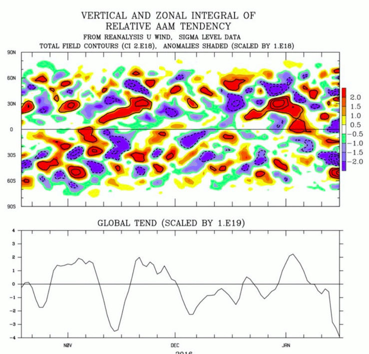
12Z GEFS backs it up with more wave 1 warming as that trough over Europe and Scandinavian ridge implodes even more. However, this still has to work its way down into 50mb before transitioning into the lower levels and then a reflection of a surface. Still, this is enough to make it interesting for the troposphere coupling POSSIBLY come mid Feb. Regardless, what has been discussed for some time now favors a wintry and cold regime beginning next weekend.
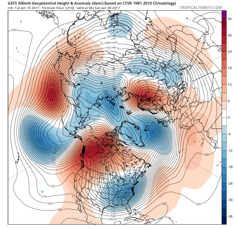
Here is your -EPO support right here as -AAM anomalies manifest over the tropics.

Armando Salvadore- Advanced Forecaster

- Posts : 171
Reputation : 0
Join date : 2016-12-23
Location : Springfield, NJ
Re: Long Range Thread 13.0
![]() by skinsfan1177 Fri Jan 20, 2017 10:26 am
by skinsfan1177 Fri Jan 20, 2017 10:26 am
skinsfan1177- Senior Enthusiast
- Posts : 4485
Reputation : 35
Join date : 2013-01-07
Age : 46
Location : Point Pleasant Boro
Re: Long Range Thread 13.0
![]() by algae888 Fri Jan 20, 2017 12:08 pm
by algae888 Fri Jan 20, 2017 12:08 pm

algae888- Advanced Forecaster
- Posts : 5311
Reputation : 46
Join date : 2013-02-05
Age : 61
Location : mt. vernon, new york
Re: Long Range Thread 13.0
![]() by algae888 Fri Jan 20, 2017 2:25 pm
by algae888 Fri Jan 20, 2017 2:25 pm
algae888- Advanced Forecaster
- Posts : 5311
Reputation : 46
Join date : 2013-02-05
Age : 61
Location : mt. vernon, new york
Re: Long Range Thread 13.0
![]() by Snow88 Fri Jan 20, 2017 2:44 pm
by Snow88 Fri Jan 20, 2017 2:44 pm
algae888 wrote:Ensambles a breaking down the pattern change by February 4th with the ridge popping back up in the east. Not good sign
What ensembles? I don't see any ridge on the ensembles.

Snow88- Senior Enthusiast
- Posts : 2193
Reputation : 4
Join date : 2013-01-09
Age : 35
Location : Brooklyn, NY
Re: Long Range Thread 13.0
![]() by algae888 Fri Jan 20, 2017 3:08 pm
by algae888 Fri Jan 20, 2017 3:08 pm
Snow Heights are rising in the East the trough is now on the Canadian border and the PNA Ridge is now retrograding back towards the aleutians not a good signSnow88 wrote:algae888 wrote:Ensambles a breaking down the pattern change by February 4th with the ridge popping back up in the east. Not good sign
What ensembles? I don't see any ridge on the ensembles.
algae888- Advanced Forecaster
- Posts : 5311
Reputation : 46
Join date : 2013-02-05
Age : 61
Location : mt. vernon, new york
Re: Long Range Thread 13.0
![]() by Frank_Wx Fri Jan 20, 2017 3:17 pm
by Frank_Wx Fri Jan 20, 2017 3:17 pm


Also, don't forget the changes we're seeing at the Stratosphere will not transcend down to the Trop until 2 weeks later. So I think there could be a brief 3-5 day period of warmer than normal days in after February 5th, but then a second pattern change should happen close to the middle of the month.
_________________
_______________________________________________________________________________________________________
CLICK HERE to view NJ Strong Snowstorm Classifications
Frank_Wx- Godzilla Seeker
- Posts : 21305
Reputation : 328
Join date : 2013-01-05
Age : 31
Location : Jersey City, NJ -
Re: Long Range Thread 13.0
![]() by Frank_Wx Fri Jan 20, 2017 3:19 pm
by Frank_Wx Fri Jan 20, 2017 3:19 pm
_________________
_______________________________________________________________________________________________________
CLICK HERE to view NJ Strong Snowstorm Classifications
Frank_Wx- Godzilla Seeker
- Posts : 21305
Reputation : 328
Join date : 2013-01-05
Age : 31
Location : Jersey City, NJ -
Re: Long Range Thread 13.0
![]() by CPcantmeasuresnow Fri Jan 20, 2017 3:28 pm
by CPcantmeasuresnow Fri Jan 20, 2017 3:28 pm
Frank_Wx wrote:The 27th to 4th time frame is expected to be below to much below normal. I remain confident there will be a storm event to track within that time frame.
Normal being NYC highs in the upper 30's this time of year and lows in the 26-27 range. I'm only seeing normal to above normal on my trusty weather channel app. For that time period, not a single below normal forget about much below. I will however defer to you and hope as usually happens you know something they don't.

CPcantmeasuresnow- Wx Statistician Guru

- Posts : 7274
Reputation : 230
Join date : 2013-01-07
Age : 103
Location : Eastern Orange County, NY
Re: Long Range Thread 13.0
![]() by Frank_Wx Fri Jan 20, 2017 6:45 pm
by Frank_Wx Fri Jan 20, 2017 6:45 pm
They key will be the AO. I expect it to go negative at some point after the 4th or 5th. This will lock the Trop PV over central/eastern Canada. As long as the Wave 1 event comes to fruition, which it looks like it will, we should see a period of -WPO/-EPO/-AO conditions. The magnitude of the Wave 1 event is a big deal too. Today, models don't seem as robust with it which means warmer temperatures halt at 10hPa instead of penetrating to 30-50hPa. That's a negative trend I hope is a blip. One reason why models could be backing off is the MJO wave may die off sooner than anticipated. We'll see, can't go off of data for one day.
_________________
_______________________________________________________________________________________________________
CLICK HERE to view NJ Strong Snowstorm Classifications
Frank_Wx- Godzilla Seeker
- Posts : 21305
Reputation : 328
Join date : 2013-01-05
Age : 31
Location : Jersey City, NJ -
Re: Long Range Thread 13.0
![]() by Frank_Wx Fri Jan 20, 2017 6:48 pm
by Frank_Wx Fri Jan 20, 2017 6:48 pm
CPcantmeasuresnow wrote:Frank_Wx wrote:The 27th to 4th time frame is expected to be below to much below normal. I remain confident there will be a storm event to track within that time frame.
Normal being NYC highs in the upper 30's this time of year and lows in the 26-27 range. I'm only seeing normal to above normal on my trusty weather channel app. For that time period, not a single below normal forget about much below. I will however defer to you and hope as usually happens you know something they don't.
Yea, actually next weekend doesn't look bad at all. It'll get near nornal again but not very much below. 29th is probably a better date to set for below normal temps to return.
_________________
_______________________________________________________________________________________________________
CLICK HERE to view NJ Strong Snowstorm Classifications
Frank_Wx- Godzilla Seeker
- Posts : 21305
Reputation : 328
Join date : 2013-01-05
Age : 31
Location : Jersey City, NJ -
Re: Long Range Thread 13.0
![]() by jmanley32 Fri Jan 20, 2017 6:51 pm
by jmanley32 Fri Jan 20, 2017 6:51 pm

jmanley32- Senior Enthusiast
- Posts : 20512
Reputation : 108
Join date : 2013-12-12
Age : 42
Location : Yonkers, NY
Re: Long Range Thread 13.0
![]() by Frank_Wx Fri Jan 20, 2017 6:54 pm
by Frank_Wx Fri Jan 20, 2017 6:54 pm
jmanley32 wrote:Is there still a chance that during that time frame it will be a godzilla or higher?
Yes, but the absence of blocking makes it tougher.
_________________
_______________________________________________________________________________________________________
CLICK HERE to view NJ Strong Snowstorm Classifications
Frank_Wx- Godzilla Seeker
- Posts : 21305
Reputation : 328
Join date : 2013-01-05
Age : 31
Location : Jersey City, NJ -
Re: Long Range Thread 13.0
![]() by Guest Fri Jan 20, 2017 7:00 pm
by Guest Fri Jan 20, 2017 7:00 pm
Hopefully this is only a blip. because with all the hype about the 27th going forward, coming on the heels of missing out on an epic blizzard with this Monday's monster would be crushing to say the least!
Guest- Guest
Re: Long Range Thread 13.0
![]() by Isotherm Sat Jan 21, 2017 1:16 pm
by Isotherm Sat Jan 21, 2017 1:16 pm
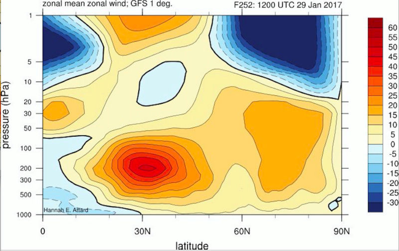
The anticipated wave-1 increase via the tropospheric precursor pattern and concomitant MJO propagation support has led to an enhanced convergence of energy at the vortex, resulting in sufficient forcing to temporarily displace the stratospheric vortex from the center of the pole. The vortex will be pushed toward Greenland at 50-10hpa by D 10. However, after which, wave-1 convergence begins to decline, and with no follow-up wave-2 assault, and so the resultant outcome may be a near miss; namely, the reduction of zonal winds at 60N/10hpa to weakly positive levels (no reversal). Right now, it appears the wave driving will be sufficient to induce a mean zonal wind reversal at the top of the atmosphere (1hpa), but not further down. Even in the case that zonal winds are temporarily reversed at 10hpa, there are a couple of significant issues: 1) This potential displacement event will likely not be one which results in the subsequent destruction of the vortex, but rather, a rapid reconsolidation and intensification of the PNJ; and, 2) Even if a SSW event were to occur, based upon my research, this would likely be an ineffectively propagating SSW event. In other words, the significant warming at the upper levels of the atmosphere will not induce meaningful alterations of the z500 northern annular mode.
What the near miss/borderline displacement will effectuate is a weaker stratospheric vortex, making it more susceptible to future assaults. The evolution of the tropospheric pattern is such that wave-2 should begin to increase by day 10, with potentially a robust spike by 2/10. Given an expected weaker vortex, a potent wave-2 attack could possibly induce a more meaningful stratospheric reversal toward mid February. However, of course, at that point, we are approaching late winter, and the effect of stratospheric warming events tends to be less dramatic. But there are examples in the data w/ analogous background conditions to this year which featured mid/late Feb SSW events. And I currently favor late winter (later in Feb into March) for the best opportunity for a genuine negative AO pattern in the troposphere. However, this is only one possibility. If the wave driving doesn’t progress, we could run the early February regime through March.
Now, what is the early February regime? The MJO aided ephemeral alterations with PNA spike and concomitant downstream trough in the East will rapidly transition into a retracted jet / Aleutian ridge / NW US trough pattern by early February – classic La Nina regime.
There will be a transient window 1/28-2/3 for a deep coastal storm on the east coast which could produce snow, when the PNA is conducive. If we do not capitalize on that period, all hope is not lost. I think poleward ridging will develop in the Aleutians given tropical forcing progression and AAM/GWO tendencies. This will force the return of a NW US trough, but if there’s sufficient geopotential height rises extending into the Arctic and/or northeast Greenland from the Scandinavian side, the baroclinic gradient would be sufficiently suppressed to permit a wintry event down to our latitude. If there’s insufficient extension of the poleward ridge, the pattern will be similar to December with February climatology: a snowier pattern for much of New England but not necessarily that good from coastal SNE southward. Overall, Feb 1-15 looks normal to warmer than normal, but not blowtorch. There will be possibilities of snow, but it isn’t a great looking winter pattern. I do believe we will achieve at least one moderate or greater snow event in the 1/28-2/12 period.
Beyond that time, the determinants of a blocky pattern will be contingent upon MJO aid, stratosphere, and other factors. At this point, I would lean toward a continuation of the largely +AO/NAO regime with an initial +PNA transient, leading toward a –EPO/-PNA for most of the first half of February. The weakened state of the stratospheric vortex should permit the neutralization of geopotential heights in the Arctic such that the upcoming few weeks is more favorable than the winter thus far for the possibility of snow. It will favor the Lakes, New England and interior however.
A resurgence of wave-2 in early-mid February could eventually lead to genuine AO/NAO pattern for later Feb-March but that is still highly speculative, and I am not willing to attach significant confidence to the idea just yet.
In sum: it appears to be the type of pattern which will gradually inch us close to my seasonal numbers of 20-26" for NYC. It's not a great pattern for NYC but it could be occasionally "serviceable" with opportunities, given February climatology and sufficient poleward ridging. That's the type of regime which will continue to favor the northern tier / New England. Temperature wise, it looks near normal to above at times at our latitude following the cold shot.
Isotherm- Advanced Forecaster
- Posts : 231
Reputation : 4
Join date : 2014-09-01
Age : 33
Location : Monmouth County, NJ -
Page 38 of 40 • 1 ... 20 ... 37, 38, 39, 40 ![]()
|
|
|