
 Search
January 7th-8th Wave 2 Snow Event
Page 7 of 25 •  1 ... 6, 7, 8 ... 16 ... 25
 ![]()
Re: January 7th-8th Wave 2 Snow Event
![]() by algae888 Thu Jan 05, 2017 4:28 am
by algae888 Thu Jan 05, 2017 4:28 am
Dry Friday night into the first part of Saturday as high pressure
noses in to the north. Then attention turns to low pressure
developing along the Southeast coast on Saturday and moving
northeast. The system is just coming onshore the West Coast, so
there is now better raob sampling of its associated mass fields.
Operational model consensus has little to no accumulation, but with
the event still 60-72 hours out, even a modest 50-mile jog NW of
model forecast, as often happens with these types of systems, could
still mean a 1-3" accumulation for eastern Long Island and SE CT,
and the 03Z SREF mean suggests this possibility. The forecast will
reflect potential for half that much, with slight chance PoP as far
west as NYC metro and western CT, and 30-40 PoP for Suffolk and
Middlesex/New London. This also maintains continuity with the
previous forecast. Lows during this time will be in the teens to
lower 20s, with highs on Sat from the 20s to lower 30s.
algae888- Advanced Forecaster

- Posts : 5311
Join date : 2013-02-05
Re: January 7th-8th Wave 2 Snow Event
![]() by algae888 Thu Jan 05, 2017 4:52 am
by algae888 Thu Jan 05, 2017 4:52 am


stronger southern stream by about 3mb. so close!
algae888- Advanced Forecaster
- Posts : 5311
Join date : 2013-02-05
Re: January 7th-8th Wave 2 Snow Event
![]() by nutleyblizzard Thu Jan 05, 2017 6:29 am
by nutleyblizzard Thu Jan 05, 2017 6:29 am

nutleyblizzard- Senior Enthusiast

- Posts : 1952
Reputation : 41
Join date : 2014-01-30
Age : 57
Location : Nutley, new jersey
Re: January 7th-8th Wave 2 Snow Event
![]() by skinsfan1177 Thu Jan 05, 2017 6:38 am
by skinsfan1177 Thu Jan 05, 2017 6:38 am

skinsfan1177- Senior Enthusiast
- Posts : 4485
Reputation : 35
Join date : 2013-01-07
Age : 46
Location : Point Pleasant Boro
Re: January 7th-8th Wave 2 Snow Event
![]() by sroc4 Thu Jan 05, 2017 7:13 am
by sroc4 Thu Jan 05, 2017 7:13 am
All that said the end result of this threat is def not quite etched in stone yet. Unfort I am fairly confident that areas N&W of I-95 are pretty much out of the game for accumulating snow; however S&E of I-95, and even more so for the immediate NJ and LI coastline are still in line for a minor, "maybe" moderate event best case scenario esp if we still have a jog of as little as 50miles or so +/- as was nicely stated by the Upton discussion posted above. Let me also be clear on he fact that another jog 50miles S&E and everyone is out of the game.
As you can see below as of initiation of the 00z Suites the N energy that is the steering mechanism to our system is still way up N only now diving into Canada. So again there is still wiggle room for models to adjust the exact track. What has become more clear however, is that the southern branch energy will not be quite as strong as the euro soln showed from 12z Jan 3rd and 00z Jan 4th as it digs into the SE CONUS. Even this; however, has a small window to improve as well. So I will cont to moniotor the system, but remain quieter than the past few days.

Now before I go this morning I would like to acknowledge a certain someone who has remained unnervingly quite throughout the past 5 days. I know he has been checking in on the discussions; however, here was a post he had about this system back on Dec 30th.
Careful, it's not a +PNA pattern. Look at the ensembles. It's a trough just off of western/northwestern North America, which favors ridge amplification east of the PNA region and troughing over the Northeast. With a pattern like that, I suspect any system will end up remaining mostly, if not entirely offshore by the time it reaches our latitude, as stronger confluence develops overhead between the backside of the trough and eastern flank of the central U.S. ridge. However, with the progged east-based NAO block, it might buckle the flow enough to where northern New England can capitalize. Just my opinion, though; certainly not fact. I could very well be wrong.
My gut is telling me that despite the teasing from the models he continued to feel confident about the general outcome of the system due to the big picture he saw in the pattern, and didn't want to sound like a broken record by telling it how it is and didn't want to burst any bubbles because of the excitement procured by the occasional run of a more favorable outcome on certain models at certain times along the way. Obv I don't want to speak form the man him self but hopefully he will come out from behind the curtain and take his humble bow. lol
Sooooo

RAY (rb)!!!!!!!!!!!!!!!!!!
_________________
"In weather and in life, there's no winning and losing; there's only winning and learning."
WINTER 2012/2013 TOTALS 43.65"WINTER 2017/2018 TOTALS 62.85" WINTER 2022/2023 TOTALS 4.9"
WINTER 2013/2014 TOTALS 64.85"WINTER 2018/2019 TOTALS 14.25" WINTER 2023/2024 TOTALS 13.1"
WINTER 2014/2015 TOTALS 71.20"WINTER 2019/2020 TOTALS 6.35"
WINTER 2015/2016 TOTALS 35.00"WINTER 2020/2021 TOTALS 37.75"
WINTER 2016/2017 TOTALS 42.25"WINTER 2021/2022 TOTALS 31.65"

sroc4- Admin

- Posts : 8331
Reputation : 301
Join date : 2013-01-07
Location : Wading River, LI
Re: January 7th-8th Wave 2 Snow Event
![]() by Frank_Wx Thu Jan 05, 2017 7:57 am
by Frank_Wx Thu Jan 05, 2017 7:57 am
_________________
_______________________________________________________________________________________________________
CLICK HERE to view NJ Strong Snowstorm Classifications

Frank_Wx- Godzilla Seeker
- Posts : 21305
Reputation : 328
Join date : 2013-01-05
Age : 31
Location : Jersey City, NJ -

Re: January 7th-8th Wave 2 Snow Event
![]() by Frank_Wx Thu Jan 05, 2017 8:02 am
by Frank_Wx Thu Jan 05, 2017 8:02 am

_________________
_______________________________________________________________________________________________________
CLICK HERE to view NJ Strong Snowstorm Classifications
Frank_Wx- Godzilla Seeker
- Posts : 21305
Reputation : 328
Join date : 2013-01-05
Age : 31
Location : Jersey City, NJ -
Re: January 7th-8th Wave 2 Snow Event
![]() by Sanchize06 Thu Jan 05, 2017 9:22 am
by Sanchize06 Thu Jan 05, 2017 9:22 am

Sanchize06- Senior Enthusiast
- Posts : 1041
Reputation : 21
Join date : 2013-02-05
Location : Union Beach, NJ
Re: January 7th-8th Wave 2 Snow Event
![]() by Sanchize06 Thu Jan 05, 2017 9:28 am
by Sanchize06 Thu Jan 05, 2017 9:28 am

Sanchize06- Senior Enthusiast
- Posts : 1041
Reputation : 21
Join date : 2013-02-05
Location : Union Beach, NJ
Re: January 7th-8th Wave 2 Snow Event
![]() by Frank_Wx Thu Jan 05, 2017 9:29 am
by Frank_Wx Thu Jan 05, 2017 9:29 am

_________________
_______________________________________________________________________________________________________
CLICK HERE to view NJ Strong Snowstorm Classifications
Frank_Wx- Godzilla Seeker
- Posts : 21305
Reputation : 328
Join date : 2013-01-05
Age : 31
Location : Jersey City, NJ -
Re: January 7th-8th Wave 2 Snow Event
![]() by aiannone Thu Jan 05, 2017 9:30 am
by aiannone Thu Jan 05, 2017 9:30 am
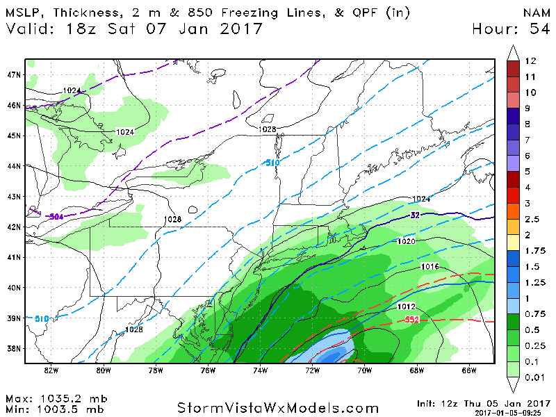

Nam Definitely a bit west of 0z. 12z on top, 0z on bottom
_________________
-Alex Iannone-

aiannone- Senior Enthusiast - Mod

- Posts : 4813
Reputation : 92
Join date : 2013-01-07
Location : Saint James, LI (Northwest Suffolk Co.)
Re: January 7th-8th Wave 2 Snow Event
![]() by Frank_Wx Thu Jan 05, 2017 9:31 am
by Frank_Wx Thu Jan 05, 2017 9:31 am
_________________
_______________________________________________________________________________________________________
CLICK HERE to view NJ Strong Snowstorm Classifications
Frank_Wx- Godzilla Seeker
- Posts : 21305
Reputation : 328
Join date : 2013-01-05
Age : 31
Location : Jersey City, NJ -


Quietace- Meteorologist - Mod

- Posts : 3687
Reputation : 33
Join date : 2013-01-07
Age : 27
Location : Point Pleasant, NJ
Re: January 7th-8th Wave 2 Snow Event
![]() by Frank_Wx Thu Jan 05, 2017 9:32 am
by Frank_Wx Thu Jan 05, 2017 9:32 am
_________________
_______________________________________________________________________________________________________
CLICK HERE to view NJ Strong Snowstorm Classifications
Frank_Wx- Godzilla Seeker
- Posts : 21305
Reputation : 328
Join date : 2013-01-05
Age : 31
Location : Jersey City, NJ -
Re: January 7th-8th Wave 2 Snow Event
![]() by Sanchize06 Thu Jan 05, 2017 9:32 am
by Sanchize06 Thu Jan 05, 2017 9:32 am
Frank_Wx wrote:SREFS AND NAM HAVE MODERATE SNOW FOR THE COAST SATURDAY EVENING. WE'LL SEE IF GLOBAL MODELS JOIN THE PARTY. THERE IS A PIECE OF THE PV TRYING TO PHASE INTO THE SOUTHERN S/W.
Sanchize06- Senior Enthusiast
- Posts : 1041
Reputation : 21
Join date : 2013-02-05
Location : Union Beach, NJ
Re: January 7th-8th Wave 2 Snow Event
![]() by aiannone Thu Jan 05, 2017 9:32 am
by aiannone Thu Jan 05, 2017 9:32 am
Frank_Wx wrote:The post Alex just made shows the 00z vs. 12z NAM at the same time frame. LOOK AT THAT WEST SHIFT
_________________
-Alex Iannone-
aiannone- Senior Enthusiast - Mod
- Posts : 4813
Reputation : 92
Join date : 2013-01-07
Location : Saint James, LI (Northwest Suffolk Co.)


Quietace- Meteorologist - Mod
- Posts : 3687
Reputation : 33
Join date : 2013-01-07
Age : 27
Location : Point Pleasant, NJ
Re: January 7th-8th Wave 2 Snow Event
![]() by bobjohnsonforthehall Thu Jan 05, 2017 9:39 am
by bobjohnsonforthehall Thu Jan 05, 2017 9:39 am
Frank_Wx wrote:The post Alex just made shows the 00z vs. 12z NAM at the same time frame. LOOK AT THAT WEST SHIFT
Is it a shift west or a shift north? Or both?

bobjohnsonforthehall- Posts : 311
Reputation : 19
Join date : 2016-10-02
Location : Flemington NJ
Re: January 7th-8th Wave 2 Snow Event
![]() by jmanley32 Thu Jan 05, 2017 9:40 am
by jmanley32 Thu Jan 05, 2017 9:40 am

jmanley32- Senior Enthusiast
- Posts : 20512
Reputation : 108
Join date : 2013-12-12
Age : 42
Location : Yonkers, NY
Re: January 7th-8th Wave 2 Snow Event
![]() by Quietace Thu Jan 05, 2017 9:41 am
by Quietace Thu Jan 05, 2017 9:41 am


Quietace- Meteorologist - Mod
- Posts : 3687
Reputation : 33
Join date : 2013-01-07
Age : 27
Location : Point Pleasant, NJ

Sanchize06- Senior Enthusiast
- Posts : 1041
Reputation : 21
Join date : 2013-02-05
Location : Union Beach, NJ
Re: January 7th-8th Wave 2 Snow Event
![]() by sroc4 Thu Jan 05, 2017 9:53 am
by sroc4 Thu Jan 05, 2017 9:53 am

_________________
"In weather and in life, there's no winning and losing; there's only winning and learning."
WINTER 2012/2013 TOTALS 43.65"WINTER 2017/2018 TOTALS 62.85" WINTER 2022/2023 TOTALS 4.9"
WINTER 2013/2014 TOTALS 64.85"WINTER 2018/2019 TOTALS 14.25" WINTER 2023/2024 TOTALS 13.1"
WINTER 2014/2015 TOTALS 71.20"WINTER 2019/2020 TOTALS 6.35"
WINTER 2015/2016 TOTALS 35.00"WINTER 2020/2021 TOTALS 37.75"
WINTER 2016/2017 TOTALS 42.25"WINTER 2021/2022 TOTALS 31.65"
sroc4- Admin
- Posts : 8331
Reputation : 301
Join date : 2013-01-07
Location : Wading River, LI
Re: January 7th-8th Wave 2 Snow Event
![]() by Frank_Wx Thu Jan 05, 2017 10:00 am
by Frank_Wx Thu Jan 05, 2017 10:00 am

_________________
_______________________________________________________________________________________________________
CLICK HERE to view NJ Strong Snowstorm Classifications
Frank_Wx- Godzilla Seeker
- Posts : 21305
Reputation : 328
Join date : 2013-01-05
Age : 31
Location : Jersey City, NJ -
Re: January 7th-8th Wave 2 Snow Event
![]() by Frank_Wx Thu Jan 05, 2017 10:04 am
by Frank_Wx Thu Jan 05, 2017 10:04 am

_________________
_______________________________________________________________________________________________________
CLICK HERE to view NJ Strong Snowstorm Classifications
Frank_Wx- Godzilla Seeker
- Posts : 21305
Reputation : 328
Join date : 2013-01-05
Age : 31
Location : Jersey City, NJ -
Re: January 7th-8th Wave 2 Snow Event
![]() by Frank_Wx Thu Jan 05, 2017 10:05 am
by Frank_Wx Thu Jan 05, 2017 10:05 am

_________________
_______________________________________________________________________________________________________
CLICK HERE to view NJ Strong Snowstorm Classifications
Frank_Wx- Godzilla Seeker
- Posts : 21305
Reputation : 328
Join date : 2013-01-05
Age : 31
Location : Jersey City, NJ -
Page 7 of 25 • 1 ... 6, 7, 8 ... 16 ... 25 ![]()
|
|
|