
 Search
FEB 6TH POTENTIAL Update
Page 1 of 2 • 1, 2 ![]()

FEB 6TH POTENTIAL Update
![]() by sroc4 Tue Jan 31, 2017 10:34 am
by sroc4 Tue Jan 31, 2017 10:34 am
There seems to be a little bit of a war regarding the progression of the MJO from the GEFs vs the rest really. Regarding the 5th-7th system the CMC cutting unfort fits if the European...if euro MJO progression holds true. The GEFS led the way with the current progression of 8-1-2, and the euro played catch up with it. We shall see/hope this is the case once again
From two mets about the MJO
"The MJO helped set off the pattern change that we are seeing now, and the wave breaking in the Pacific it helped set off keeps its effects going a bit longer. But it initially came through in such a warm regime with a strong PAC Jet that there was a huge lag between the MJO phase and our actual temperatures.
I'm currently analyzing the MJO, I'm skeptical of all guidance right now as we all should be, however I currently think that a compromise between the ECMWF and GEFS is most likely, leaving tropical forcing and background state plus omega Arctic North Pacific ridge leading to snow for all of us. " JM
Even still a compromise still has our MJO come out in late 5-6 which may still allow our SE ridge to flex if the -EPO/-WPO arctic blocking regime is over modeled at all, and or axis is shifted west. After all this entire winter we have been under the background influence of La Nina forcings. So if other pattern enhancers do not end up being as strong as originally thought then that SE ridge pops back up. There are no gaurantees either way at this stage.
When looking at the snow event earlier in Jan the European came around to the GFS's idea of the MJO coming out in phases 8-1-2, so it made sense that there was no reason to believe the European could not come back around to the idea the GEFS had a few days ago having the MJO pulse come out in 7 and propagate through 7-8-1. Looking at the temp anomaly map below if the GEFS were correct we would be transitioning from 7 a warm but transitional phase into the colder phases of 8-1.

However this clearly is no longer the case. I wish I saved the GEFS and EPS MJO forecast from a few days ago to show you the diff vs now. For now you can see the GEFS have trended to the euro with fairly good agreement of a modest MJO pulse coming out in phase 4 before propagating modestly through phases 5-6 which if you look at the map above clearly are warm phases in the east.


Now in the quoted sections above from the Jan 27th discussions I mentioned that the MJO is not the only player on the field. (...if other pattern enhancers do not end up being as strong as originally thought then that SE ridge pops back up.) The trop Pac has persistently been governing our big picture pattern throughout the winter thus far(La Nina like forcings which is consistent with MJO in these warm phases 4-5-6) with short term pattern changers like anomalous -EPO and or -WPO ridging for example. This is beginning to shape up no different for the upcoming chances on both the 6th and the 9th-10th; however, in no way is the final soln written in stone.
Specifically regarding the 6th threat now. Initially I was worried about the SE ridge rearing up and we get a cutting soln for the 6th because of the MJO concerns in the warm phases. This is still possible for the 6th; however, I think the anomalous -EPO/-WPO ridge will prevent that from happening, but the big picture is undergoing the transition to a pattern that is in FACT consistent with a modest MJO pulse into these warm phases. (this is why a nasty cutting system following the 6th is totally possible once the -EPO/-WPO ridge backs off a retrogrades back after the 6th. Lets look at the models.
With now both GFS and Euro MJO forecasts com,ing in line we have to ask if the Modeling is consistent with this forecast, and unfort it is. On both the GFS, and Euro we are now consistently getting a more anomalous trough along the west coast of Canada instead of having that trough retrograde back and consolidate more with the sub Aleutian trough. This is what Ray was highlighting in his video might happen if the GFS from several days ago was correct. Lets loomk at the upper level pattern. H5, as of Sunday 12z

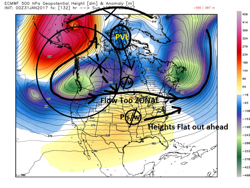
Two extremely important things have evolved in the modeling over the last several days.
1) Our Pac short wave(s/w) has trended weaker. If we want to have any chance at snow we need it to trend back stronger, but not too strong. As has been pointed out already a stronger system will help to raise heights out ahead of it which changes the storm track from west to east to more NE. A weak system like is modeled now does not do that, and since other key features are less than ideal the system will remain on a very zonal trajectory, aka west to east.
2) In the images above focus on the large area I have circled along the west coast of Canada. This is the area I am most concerned with as GFS op, Euro Op as well as both Ensemble mean forecasts are coming into alignment. The idea that a broad trough that communicates with centra Canada instead of this trough cutting off from the main cross polar flow and retrograding back off the west coast of Canada leads to a zonal flow across the Northern CONUS. With that nice strong -EPO/-WPO ridge one would expect a digging s/w into the conus, but instead this zonal flow prevents the arctic air from digging. The result is little or no phasing at all with the Pac s/w and the s/w embedded within the polar jet. No phasing means heights will remain flat out ahead of our Pac s/w system; esp if that system remains weak.
Looking back at the image above what did not happen is we are not getting the stronger ridge bridging between the Scandinavian ridge and the -EPO/-WPO bridge. The result is the polar vortex lobe (PVL) I have labeled is too far north. We need that lobe to sink south over the Hudson Bay in order to force the western Canadian trough to cutoff from the cross polar flow. (seen as the dashed line in this region). This in turn allows the s/w in the northern branch to dig into the conus rather than harmlessly head west to east waving at our Pac s/w from across the zonal flow N of the boarder. Like two kids waving at each other in cars driving side by side. If the car in the L lane decides to steer itself into the car in the R lane, then you go BOOM with our system. Unfortunately the evolution in the modeling fits very nicely with the evolution in the MJO forecasting.
Just to show you what the GFS looked like a few days ago here is H5...same time frame, but from the 12z Jan 29th GFS run. Notice instead of the anomalous trough along the west coast of Canada(dashed lines in image below) we actually have warm height anomalies indicating ridging in this region and we maintain the true cross polar flow set up by the anomalous -EPO/-WPO ridge which allows the N branch s/w to dig into the CONUS and a much better system along the EC as a result.

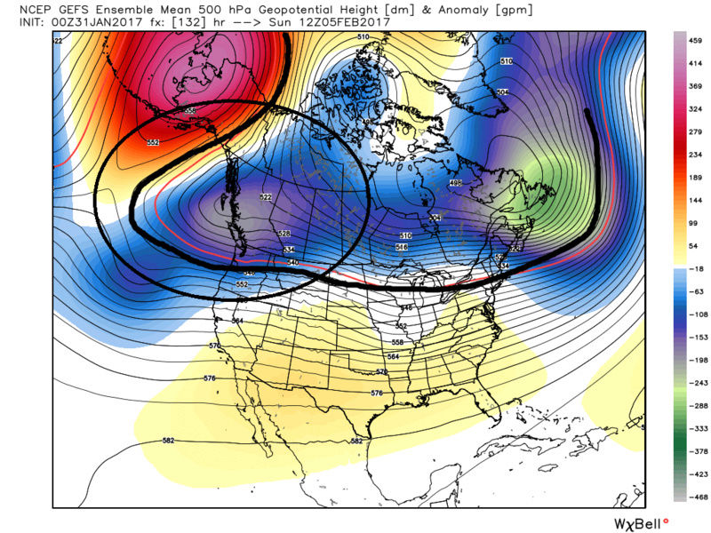
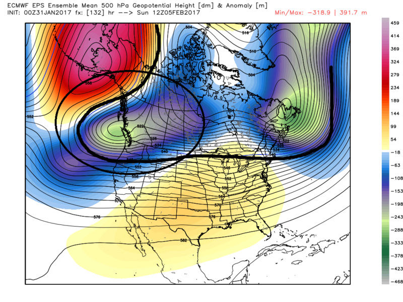
Below is the GEFS and the EPS. Just look how close they are with each other, as well as their operational forecasts above: Disconcerting to say the least.
The reason we likely don't get a cutting system and a true flare up of the SE ridge is because the -EPO/-WPO has the tail end of the very cold air mass associated with the passing clipper that is happening now and over the next 24 hrs. This prevents the SE ridge from going crazy. This is also why as Ray and Frank point out that IF we can get the Pac s/w energy to trend stronger the balance between this cold air mass and the flare up of the SE ridge may allow heights to raise out ahead of the system just enough to allow a transfer to the coast and a better trajectory in a NE direction rather than a strait W to E. This would allow for at least a modest event. IMHO unless we get more digging of the N s/w Godzilla is off the table for now. And unless the Pac s/w trends stronger maybe even Mothrazilla comes off the table. The idea of seeing nothing, esp N sections is unfort still on the table as well. Like has been stated the energy that is this system does not come on shore until at least late Friday into early Sat so we will see how things go. This is only how things are modeled now. Again major big picture ideas can still evolve some so lets see. Temper expectations though as trends have not been our friend thus far.
The last thought is to the potential system behind this one for the 9th time frame. Again the way the pattern is setting up the most likely result will be a cutter due to the evolution of the trop Pac as outline above. We would be in the heart of the phase 5-6 MJO pulse for this system IF the forecast wee to verify...please don't shoot the messenger.
_________________
"In weather and in life, there's no winning and losing; there's only winning and learning."
WINTER 2012/2013 TOTALS 43.65"WINTER 2017/2018 TOTALS 62.85" WINTER 2022/2023 TOTALS 4.9"
WINTER 2013/2014 TOTALS 64.85"WINTER 2018/2019 TOTALS 14.25" WINTER 2023/2024 TOTALS 13.1"
WINTER 2014/2015 TOTALS 71.20"WINTER 2019/2020 TOTALS 6.35"
WINTER 2015/2016 TOTALS 35.00"WINTER 2020/2021 TOTALS 37.75"
WINTER 2016/2017 TOTALS 42.25"WINTER 2021/2022 TOTALS 31.65"

sroc4- Admin

- Posts : 8331
Reputation : 301
Join date : 2013-01-07
Location : Wading River, LI
Re: FEB 6TH POTENTIAL Update
![]() by sroc4 Tue Jan 31, 2017 10:35 am
by sroc4 Tue Jan 31, 2017 10:35 am
_________________
"In weather and in life, there's no winning and losing; there's only winning and learning."
WINTER 2012/2013 TOTALS 43.65"WINTER 2017/2018 TOTALS 62.85" WINTER 2022/2023 TOTALS 4.9"
WINTER 2013/2014 TOTALS 64.85"WINTER 2018/2019 TOTALS 14.25" WINTER 2023/2024 TOTALS 13.1"
WINTER 2014/2015 TOTALS 71.20"WINTER 2019/2020 TOTALS 6.35"
WINTER 2015/2016 TOTALS 35.00"WINTER 2020/2021 TOTALS 37.75"
WINTER 2016/2017 TOTALS 42.25"WINTER 2021/2022 TOTALS 31.65"
sroc4- Admin
- Posts : 8331
Reputation : 301
Join date : 2013-01-07
Location : Wading River, LI
Re: FEB 6TH POTENTIAL Update
![]() by rb924119 Tue Jan 31, 2017 11:11 am
by rb924119 Tue Jan 31, 2017 11:11 am
rb924119- Meteorologist

- Posts : 6889
Reputation : 194
Join date : 2013-02-06
Age : 32
Location : Greentown, Pa
Re: FEB 6TH POTENTIAL Update
![]() by amugs Tue Jan 31, 2017 11:37 am
by amugs Tue Jan 31, 2017 11:37 am
So frustrating and unfortunate, we still have a chance but that is about 30% in my book about but could change of course.
Also, the sun has a massive coronal hole which will not help us at all as pointed out by another forum member and sunspots albeit weak are upticking the last few days.

Coronal Hole - UGGHHHH!!!
http://spaceweather.com/
_________________
Mugs
AKA:King: Snow Weenie
Self Proclaimed
WINTER 2014-15 : 55.12" +.02 for 6 coatings (avg. 35")
WINTER 2015-16 Total - 29.8" (Avg 35")
WINTER 2016-17 : 39.5" so far

amugs- Advanced Forecaster - Mod

- Posts : 15091
Reputation : 213
Join date : 2013-01-07
Age : 54
Location : Hillsdale,NJ
Re: FEB 6TH POTENTIAL Update
![]() by sroc4 Tue Jan 31, 2017 12:06 pm
by sroc4 Tue Jan 31, 2017 12:06 pm
But the European model has been much more muted with the pulse when compared to the more recent GEFS runs. We will see if the modeling still has some tricks up its sleeve. Don't be surprised if the answer to that is yes. For better or worse.
_________________
"In weather and in life, there's no winning and losing; there's only winning and learning."
WINTER 2012/2013 TOTALS 43.65"WINTER 2017/2018 TOTALS 62.85" WINTER 2022/2023 TOTALS 4.9"
WINTER 2013/2014 TOTALS 64.85"WINTER 2018/2019 TOTALS 14.25" WINTER 2023/2024 TOTALS 13.1"
WINTER 2014/2015 TOTALS 71.20"WINTER 2019/2020 TOTALS 6.35"
WINTER 2015/2016 TOTALS 35.00"WINTER 2020/2021 TOTALS 37.75"
WINTER 2016/2017 TOTALS 42.25"WINTER 2021/2022 TOTALS 31.65"
sroc4- Admin
- Posts : 8331
Reputation : 301
Join date : 2013-01-07
Location : Wading River, LI
Re: FEB 6TH POTENTIAL Update
![]() by amugs Tue Jan 31, 2017 12:12 pm
by amugs Tue Jan 31, 2017 12:12 pm
_________________
Mugs
AKA:King: Snow Weenie
Self Proclaimed
WINTER 2014-15 : 55.12" +.02 for 6 coatings (avg. 35")
WINTER 2015-16 Total - 29.8" (Avg 35")
WINTER 2016-17 : 39.5" so far
amugs- Advanced Forecaster - Mod
- Posts : 15091
Reputation : 213
Join date : 2013-01-07
Age : 54
Location : Hillsdale,NJ
Re: FEB 6TH POTENTIAL Update
![]() by Guest Tue Jan 31, 2017 12:22 pm
by Guest Tue Jan 31, 2017 12:22 pm
amugs wrote:Scott^^ i hear ya but the fact that this 1 two week period was to be a changing pattern and one to more wintry and multiple snow chances is getting beatin' down. Incredible IMO but its the weather.
not incredible......totally par for the course this winter. good news is cutter forecast to follow. That will verify.
Guest- Guest

SoulSingMG- Senior Enthusiast

- Posts : 2853
Reputation : 74
Join date : 2013-12-11
Location : Long Island City, NY
Re: FEB 6TH POTENTIAL Update
![]() by nutleyblizzard Tue Jan 31, 2017 3:02 pm
by nutleyblizzard Tue Jan 31, 2017 3:02 pm
I was thinking of the same thing this morning. If the Super Bowl storm remains weak, would it affect the pattern going forward? Our only hope is that the models brings the storm back like SteveD says.SoulSingMG wrote:FWIW......

nutleyblizzard- Senior Enthusiast
- Posts : 1952
Reputation : 41
Join date : 2014-01-30
Age : 57
Location : Nutley, new jersey
Re: FEB 6TH POTENTIAL Update
![]() by sroc4 Tue Jan 31, 2017 3:11 pm
by sroc4 Tue Jan 31, 2017 3:11 pm
SoulSingMG wrote:FWIW......
This is nothing new. It was stated in the original write up. (Like has been stated the energy that is this system does not come on shore until at least late Friday into early Sat so we will see how things go. This is only how things are modeled now. Again major big picture ideas can still evolve some so lets see.)
He is correct in that if there is a phase or even a partial phase the results after the 6th will be altered. Enough to prevent a cutter around the 8th-9th? I'm not so sure, but altered to what we see now, maybe.
_________________
"In weather and in life, there's no winning and losing; there's only winning and learning."
WINTER 2012/2013 TOTALS 43.65"WINTER 2017/2018 TOTALS 62.85" WINTER 2022/2023 TOTALS 4.9"
WINTER 2013/2014 TOTALS 64.85"WINTER 2018/2019 TOTALS 14.25" WINTER 2023/2024 TOTALS 13.1"
WINTER 2014/2015 TOTALS 71.20"WINTER 2019/2020 TOTALS 6.35"
WINTER 2015/2016 TOTALS 35.00"WINTER 2020/2021 TOTALS 37.75"
WINTER 2016/2017 TOTALS 42.25"WINTER 2021/2022 TOTALS 31.65"
sroc4- Admin
- Posts : 8331
Reputation : 301
Join date : 2013-01-07
Location : Wading River, LI
Re: FEB 6TH POTENTIAL Update
![]() by Ronniek Tue Jan 31, 2017 3:13 pm
by Ronniek Tue Jan 31, 2017 3:13 pm
Ronniek- Posts : 13
Reputation : 0
Join date : 2013-12-24
Re: FEB 6TH POTENTIAL Update
![]() by frank 638 Tue Jan 31, 2017 5:02 pm
by frank 638 Tue Jan 31, 2017 5:02 pm
frank 638- Senior Enthusiast
- Posts : 2823
Reputation : 37
Join date : 2016-01-01
Age : 40
Location : bronx ny
Re: FEB 6TH POTENTIAL Update
![]() by Guest Tue Jan 31, 2017 5:09 pm
by Guest Tue Jan 31, 2017 5:09 pm
frank 638 wrote:So let me guess for the Super Bowl storm we will get another coating to an 1 of snow followed by another rainstorm on the 8 the of Feb what a great winter so far


Guest- Guest
frank 638- Senior Enthusiast
- Posts : 2823
Reputation : 37
Join date : 2016-01-01
Age : 40
Location : bronx ny
Re: FEB 6TH POTENTIAL Update
![]() by Guest Tue Jan 31, 2017 5:17 pm
by Guest Tue Jan 31, 2017 5:17 pm
syosnow94 wrote:frank 638 wrote:So let me guess for the Super Bowl storm we will get another coating to an 1 of snow followed by another rainstorm on the 8 the of Feb what a great winter so far
Nobody is more deserving of having "enthusiast" in their title than you are.
Guest- Guest

HectorO- Pro Enthusiast

- Posts : 959
Reputation : 27
Join date : 2013-01-11
Re: FEB 6TH POTENTIAL Update
![]() by Guest Tue Jan 31, 2017 5:35 pm
by Guest Tue Jan 31, 2017 5:35 pm
HectorO wrote:What the hell is a Mothrazilla?
6-11 inches.
Followed by Godzilla (12-23), Roidzilla (24-35) and the Frankzilla (36+) .
Sroc, I've tried to delete this post and the one above it, but there is no delete option where there should be.
Last edited by TheAresian on Tue Jan 31, 2017 5:52 pm; edited 2 times in total
Guest- Guest
Re: FEB 6TH POTENTIAL Update
![]() by sroc4 Tue Jan 31, 2017 5:37 pm
by sroc4 Tue Jan 31, 2017 5:37 pm
_________________
"In weather and in life, there's no winning and losing; there's only winning and learning."
WINTER 2012/2013 TOTALS 43.65"WINTER 2017/2018 TOTALS 62.85" WINTER 2022/2023 TOTALS 4.9"
WINTER 2013/2014 TOTALS 64.85"WINTER 2018/2019 TOTALS 14.25" WINTER 2023/2024 TOTALS 13.1"
WINTER 2014/2015 TOTALS 71.20"WINTER 2019/2020 TOTALS 6.35"
WINTER 2015/2016 TOTALS 35.00"WINTER 2020/2021 TOTALS 37.75"
WINTER 2016/2017 TOTALS 42.25"WINTER 2021/2022 TOTALS 31.65"
sroc4- Admin
- Posts : 8331
Reputation : 301
Join date : 2013-01-07
Location : Wading River, LI
Re: FEB 6TH POTENTIAL Update
![]() by Guest Tue Jan 31, 2017 5:38 pm
by Guest Tue Jan 31, 2017 5:38 pm
Guest- Guest
Re: FEB 6TH POTENTIAL Update
![]() by sroc4 Tue Jan 31, 2017 5:44 pm
by sroc4 Tue Jan 31, 2017 5:44 pm
TheAresian wrote:The SOI is the highest it's been in 3 weeks. Doesn't that fit in with the idea that there is a 5-7 days lag between the SOI and the effects on the east coast?
The SOI daily value is a shade over 12 which is typical of La Niña. It is the first time it's been here since early Jan. But it fits with the MJO projections unfort. Esp if we get a few more days in positive territory
_________________
"In weather and in life, there's no winning and losing; there's only winning and learning."
WINTER 2012/2013 TOTALS 43.65"WINTER 2017/2018 TOTALS 62.85" WINTER 2022/2023 TOTALS 4.9"
WINTER 2013/2014 TOTALS 64.85"WINTER 2018/2019 TOTALS 14.25" WINTER 2023/2024 TOTALS 13.1"
WINTER 2014/2015 TOTALS 71.20"WINTER 2019/2020 TOTALS 6.35"
WINTER 2015/2016 TOTALS 35.00"WINTER 2020/2021 TOTALS 37.75"
WINTER 2016/2017 TOTALS 42.25"WINTER 2021/2022 TOTALS 31.65"
sroc4- Admin
- Posts : 8331
Reputation : 301
Join date : 2013-01-07
Location : Wading River, LI
Re: FEB 6TH POTENTIAL Update
![]() by RJB8525 Tue Jan 31, 2017 5:55 pm
by RJB8525 Tue Jan 31, 2017 5:55 pm
TheAresian wrote:syosnow94 wrote:frank 638 wrote:So let me guess for the Super Bowl storm we will get another coating to an 1 of snow followed by another rainstorm on the 8 the of Feb what a great winter so far
Nobody is more deserving of having "enthusiast" in their title than you are.
This just made my day. Can't stop laughing

RJB8525- Senior Enthusiast
- Posts : 1994
Reputation : 28
Join date : 2013-02-06
Age : 38
Location : Hackettstown, NJ
Re: FEB 6TH POTENTIAL Update
![]() by Frank_Wx Tue Jan 31, 2017 7:29 pm
by Frank_Wx Tue Jan 31, 2017 7:29 pm

You can clearly spot the energy of interest on guidance. It's over the Mid Atlantic on this particular frame. But notice what's happening out west. A strong storm is pushing into Washington which forces the ridge to collapse east. Northern or polar energy ends up staying in Canada as opposed to digging into the eastern CONUS.
Most likely, this will not change and my SCI tomorrow morning will be updated to a lower percentage. I don't see how models suddenly bring the western ridge back, unless that PAC NW storm slows down significantly. The southern energy itself could still bring us minor snow amounts so we'll keep watching it. But the Mothrazilla+ event looks unlikely. Very frustrating.
_________________
_______________________________________________________________________________________________________
CLICK HERE to view NJ Strong Snowstorm Classifications

Frank_Wx- Godzilla Seeker
- Posts : 21305
Reputation : 328
Join date : 2013-01-05
Age : 31
Location : Jersey City, NJ -

Re: FEB 6TH POTENTIAL Update
![]() by rb924119 Wed Feb 01, 2017 11:09 am
by rb924119 Wed Feb 01, 2017 11:09 am
rb924119- Meteorologist
- Posts : 6889
Reputation : 194
Join date : 2013-02-06
Age : 32
Location : Greentown, Pa
Re: FEB 6TH POTENTIAL Update
![]() by SNOW MAN Wed Feb 01, 2017 11:26 am
by SNOW MAN Wed Feb 01, 2017 11:26 am
rb924119 wrote:DONT LOOK NOW, BUT 12Z GFS IMPROVED CONSIDERABLY WITH THE WESTERN RIDGE FOR SUNDAY
Sorry Rb I just can't get excited anymore. My bubble has been burst to many times this year.

SNOW MAN- Senior Enthusiast
- Posts : 1361
Reputation : 25
Join date : 2013-01-13
Age : 64
Location : Marshalls Creek Pa.
Re: FEB 6TH POTENTIAL Update
![]() by algae888 Wed Feb 01, 2017 11:27 am
by algae888 Wed Feb 01, 2017 11:27 am
Yeah rb big changes on the operational GFS today. February 6th storm really intensifies and acts as a block and now have a new system a day later which is snow to rain nice front and thump models are obviously having a hard time with the setup as all guidance from last night is starting to Trend colder in the mid-range that's why we can't model hump and panic when there's a few operational runs that show unfavorable patternrb924119 wrote:DONT LOOK NOW, BUT 12Z GFS IMPROVED CONSIDERABLY WITH THE WESTERN RIDGE FOR SUNDAY
Last edited by algae888 on Wed Feb 01, 2017 11:28 am; edited 1 time in total

algae888- Advanced Forecaster

- Posts : 5311
Reputation : 46
Join date : 2013-02-05
Age : 61
Location : mt. vernon, new york
Page 1 of 2 • 1, 2 ![]()
|
|
|