
 Search
Friday, March 10th "Wave 1" Minor Snow Event
+22
2004blackwrx
RJB8525
mmanisca
mikeypizano
frank 638
algae888
amugs
GreyBeard
Math23x7
skinsfan1177
dkodgis
billg315
Snow88
nutleyblizzard
sroc4
Armando Salvadore
SoulSingMG
weatherwatchermom
jake732
rb924119
jmanley32
Frank_Wx
26 posters
Page 8 of 8 •  1, 2, 3, 4, 5, 6, 7, 8
Re: Friday, March 10th "Wave 1" Minor Snow Event
![]() by jmanley32 Thu Mar 09, 2017 12:48 am
by jmanley32 Thu Mar 09, 2017 12:48 am
Saw his map a large part of northern jersey is in his 4-6.Snow88 wrote:Joe Cioffi is going with 4-6 for NYC with more in Long Island and less in NJ.
jmanley32- Senior Enthusiast

- Posts : 20512
Join date : 2013-12-12
Re: Friday, March 10th "Wave 1" Minor Snow Event
![]() by Snow88 Thu Mar 09, 2017 1:00 am
by Snow88 Thu Mar 09, 2017 1:00 am
Euro looks great for the area on Friday
Snow88- Senior Enthusiast
- Posts : 2193
Join date : 2013-01-09
Re: Friday, March 10th "Wave 1" Minor Snow Event
![]() by Snow88 Thu Mar 09, 2017 1:10 am
by Snow88 Thu Mar 09, 2017 1:10 am
3-5 for NYC with slightly more to the north on the Euro for Friday

Snow88- Senior Enthusiast
- Posts : 2193
Reputation : 4
Join date : 2013-01-09
Age : 35
Location : Brooklyn, NY
Re: Friday, March 10th "Wave 1" Minor Snow Event
![]() by 2004blackwrx Thu Mar 09, 2017 1:30 am
by 2004blackwrx Thu Mar 09, 2017 1:30 am
Without seeing it sounds like models are maybe coming to more on a consensus 24 hours out
2004blackwrx- Pro Enthusiast

- Posts : 576
Reputation : 9
Join date : 2013-01-14
Location : Wappinger NY
Re: Friday, March 10th "Wave 1" Minor Snow Event
![]() by frank 638 Thu Mar 09, 2017 5:31 am
by frank 638 Thu Mar 09, 2017 5:31 am
Winter weather advisory has gone up 3 to 5 inches of snow
frank 638- Senior Enthusiast
- Posts : 2823
Reputation : 37
Join date : 2016-01-01
Age : 40
Location : bronx ny
Re: Friday, March 10th "Wave 1" Minor Snow Event
![]() by Frank_Wx Thu Mar 09, 2017 5:49 am
by Frank_Wx Thu Mar 09, 2017 5:49 am
My forecast is for 3-6" of snow mainly on cold surfaces from EPA to NYC and LI. Includes SNY and NNJ. Those north and south of this zone likely in 1 to 3 inches. Midnight start time with an end time around Noon.
_________________
_______________________________________________________________________________________________________
CLICK HERE to view NJ Strong Snowstorm Classifications

Frank_Wx- Godzilla Seeker

- Posts : 21305
Reputation : 328
Join date : 2013-01-05
Age : 31
Location : Jersey City, NJ -

Re: Friday, March 10th "Wave 1" Minor Snow Event
![]() by rb924119 Thu Mar 09, 2017 6:19 am
by rb924119 Thu Mar 09, 2017 6:19 am
I honestly still think the models are overdoing this some. The cold air is coming in at the same time as the precip, it's not there before it, so some will be lost to melting regardless of it being dark. Secondly, ratios will be 14-16:1, yes, but that means more QPF will be lost to ground cooling because of the lack of water content. Secondly, there is no real anomalous moisture source for this; it's roughly around 0.5" PWAT content. With your best column-deep forcing occurring between approximately 09/10z and 13/14z, that gives you a 3-4 hour window of best snowfall rates. So, out of the 0.5" PWAT values that move overhead in the six-hour period between 06z and 12z, in my opinion it would be safe to assume that 1/2 to 2/3 of that 0.5" PWAT is fully precipitated out during the period of best ascent. Using the numbers and an average of 15:1 ratio, that yields a general 2-4/3-5" event, with most of that likely being confined to the elevations, and the rest of the snow that falls before and after this period roughly negating losses to melting from above and below. The coastal plain will have a harder time accumulating because of the warmer temperatures combined with sunrise occurring during the best snowfall rates.
So, I generally agree with Frank, although I personally feel that most five- and six-inch amounts will likely be confined to the East End and southeastern New England. Map to come later.
So, I generally agree with Frank, although I personally feel that most five- and six-inch amounts will likely be confined to the East End and southeastern New England. Map to come later.
rb924119- Meteorologist

- Posts : 6888
Reputation : 194
Join date : 2013-02-06
Age : 32
Location : Greentown, Pa
Re: Friday, March 10th "Wave 1" Minor Snow Event
![]() by SENJsnowman Thu Mar 09, 2017 6:42 am
by SENJsnowman Thu Mar 09, 2017 6:42 am
I completely agree. This set up is identical to what we had a month ago...at least it is for down the Shore. Temps in the high 50s, even low 60s the day before, so we needed a crash of 25-30 degrees overnight...except the storm came first. Rained (hard) for 3 hours and then snowed for about 3...it all added up to a slushy, mushy 1"...my 6 year old was so disappointed that she refused to recognized it as having snowed. Unless the cold gets here first this time around (and there is no indication that it will), I don't see how we'll get a different result south of I-195.
I haven't even told my daughter about tomorrow and don't have any real excitement for it myself.
Now, Tuesday on the other hand...
I haven't even told my daughter about tomorrow and don't have any real excitement for it myself.
Now, Tuesday on the other hand...
SENJsnowman- Senior Enthusiast
- Posts : 1186
Reputation : 61
Join date : 2017-01-06
Age : 51
Location : Bayville, NJ
Re: Friday, March 10th "Wave 1" Minor Snow Event
![]() by rb924119 Thu Mar 09, 2017 6:47 am
by rb924119 Thu Mar 09, 2017 6:47 am
Something else to consider is the general lack of decent isentropic lift with this system as well.....
rb924119- Meteorologist
- Posts : 6888
Reputation : 194
Join date : 2013-02-06
Age : 32
Location : Greentown, Pa
Re: Friday, March 10th "Wave 1" Minor Snow Event
![]() by sroc4 Thu Mar 09, 2017 6:54 am
by sroc4 Thu Mar 09, 2017 6:54 am
So here is my first call snowfall map. As I had alluded to in prev posts I believe there will be a fairly robust baroclinic zone with warm Atlantic moisture and temps to the south and the arctic air mass to the N which will enhance vertical motion.

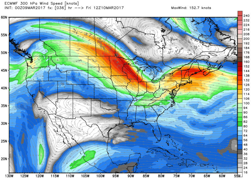
A second feature which appears consistent now on both GFS and Euro is a 300mb jet streak favorably positioned over N NE. The positioning and timing is such that as the surface LP reaches the coast it is within the favorable R Rear Quadrant of the JS which divergence aloft to the N will further enhance vertical motion and deepen the LP more rapidly, but not bomb out, enhancing QPF esp over eastern half of our area.


Additionally in prev posts I alluded to the possibility of a storm track more west to east vs one that maybe took a slight SW to NE trajectory. Latest model data including both globals and now s/r modeling indicates the trough digging more than prev forecasted into the Ohio valley. With such a vigorous vort max associated with the trough and the trough appearing to go at least neutral, but maybe even slight neg, as it approaches the region I suspect the system may end up more robust than people think. This is more of a hunch though so take it with a grain of salt.
Right now given all the above reasoning I think a bust on the low side for some areas is possible. We shall see. An updated map will be issued tonight if needed.


A second feature which appears consistent now on both GFS and Euro is a 300mb jet streak favorably positioned over N NE. The positioning and timing is such that as the surface LP reaches the coast it is within the favorable R Rear Quadrant of the JS which divergence aloft to the N will further enhance vertical motion and deepen the LP more rapidly, but not bomb out, enhancing QPF esp over eastern half of our area.
Additionally in prev posts I alluded to the possibility of a storm track more west to east vs one that maybe took a slight SW to NE trajectory. Latest model data including both globals and now s/r modeling indicates the trough digging more than prev forecasted into the Ohio valley. With such a vigorous vort max associated with the trough and the trough appearing to go at least neutral, but maybe even slight neg, as it approaches the region I suspect the system may end up more robust than people think. This is more of a hunch though so take it with a grain of salt.
Right now given all the above reasoning I think a bust on the low side for some areas is possible. We shall see. An updated map will be issued tonight if needed.
_________________
"In weather and in life, there's no winning and losing; there's only winning and learning."
WINTER 2012/2013 TOTALS 43.65"WINTER 2017/2018 TOTALS 62.85" WINTER 2022/2023 TOTALS 4.9"
WINTER 2013/2014 TOTALS 64.85"WINTER 2018/2019 TOTALS 14.25" WINTER 2023/2024 TOTALS 13.1"
WINTER 2014/2015 TOTALS 71.20"WINTER 2019/2020 TOTALS 6.35"
WINTER 2015/2016 TOTALS 35.00"WINTER 2020/2021 TOTALS 37.75"
WINTER 2016/2017 TOTALS 42.25"WINTER 2021/2022 TOTALS 31.65"

sroc4- Admin
- Posts : 8331
Reputation : 301
Join date : 2013-01-07
Location : Wading River, LI
Re: Friday, March 10th "Wave 1" Minor Snow Event
![]() by sroc4 Thu Mar 09, 2017 7:06 am
by sroc4 Thu Mar 09, 2017 7:06 am
New thread
_________________
"In weather and in life, there's no winning and losing; there's only winning and learning."
WINTER 2012/2013 TOTALS 43.65"WINTER 2017/2018 TOTALS 62.85" WINTER 2022/2023 TOTALS 4.9"
WINTER 2013/2014 TOTALS 64.85"WINTER 2018/2019 TOTALS 14.25" WINTER 2023/2024 TOTALS 13.1"
WINTER 2014/2015 TOTALS 71.20"WINTER 2019/2020 TOTALS 6.35"
WINTER 2015/2016 TOTALS 35.00"WINTER 2020/2021 TOTALS 37.75"
WINTER 2016/2017 TOTALS 42.25"WINTER 2021/2022 TOTALS 31.65"
sroc4- Admin
- Posts : 8331
Reputation : 301
Join date : 2013-01-07
Location : Wading River, LI
Re: Friday, March 10th "Wave 1" Minor Snow Event
![]() by SNOW MAN Thu Mar 09, 2017 7:07 am
by SNOW MAN Thu Mar 09, 2017 7:07 am
sroc4 wrote:So here is my first call snowfall map. As I had alluded to in prev posts I believe there will be a fairly robust baroclinic zone with warm Atlantic moisture and temps to the south and the arctic air mass to the N which will enhance vertical motion.
A second feature which appears consistent now on both GFS and Euro is a 300mb jet streak favorably positioned over N NE. The positioning and timing is such that as the surface LP reaches the coast it is within the favorable R Rear Quadrant of the JS which divergence aloft to the N will further enhance vertical motion and deepen the LP more rapidly, but not bomb out, enhancing QPF esp over eastern half of our area.
Additionally in prev posts I alluded to the possibility of a storm track more west to east vs one that maybe took a slight SW to NE trajectory. Latest model data including both globals and now s/r modeling indicates the trough digging more than prev forecasted into the Ohio valley. With such a vigorous vort max associated with the trough and the trough appearing to go at least neutral, but maybe even slight neg, as it approaches the region I suspect the system may end up more robust than people think. This is more of a hunch though so take it with a grain of salt.
Right now given all the above reasoning I think a bust on the low side for some areas is possible. We shall see. An updated map will be issued tonight if needed.
Doc, I have a question about your map. Is there any way for you to make the state line more clear between PA. and N.J. ? It's really hard to see it. Of course I live in PA. and it would be a big help. I live just above where N.J. protrudes into PA. by the Gap. And thanks for all the work you put into this site. It's really appreciated. I still love your photo you use as your avatar. Thanks.

SNOW MAN- Senior Enthusiast
- Posts : 1361
Reputation : 25
Join date : 2013-01-13
Age : 64
Location : Marshalls Creek Pa.
Re: Friday, March 10th "Wave 1" Minor Snow Event
![]() by sroc4 Thu Mar 09, 2017 7:19 am
by sroc4 Thu Mar 09, 2017 7:19 am
Snow man I tried to fix a little. Check the other thread
_________________
"In weather and in life, there's no winning and losing; there's only winning and learning."
WINTER 2012/2013 TOTALS 43.65"WINTER 2017/2018 TOTALS 62.85" WINTER 2022/2023 TOTALS 4.9"
WINTER 2013/2014 TOTALS 64.85"WINTER 2018/2019 TOTALS 14.25" WINTER 2023/2024 TOTALS 13.1"
WINTER 2014/2015 TOTALS 71.20"WINTER 2019/2020 TOTALS 6.35"
WINTER 2015/2016 TOTALS 35.00"WINTER 2020/2021 TOTALS 37.75"
WINTER 2016/2017 TOTALS 42.25"WINTER 2021/2022 TOTALS 31.65"
sroc4- Admin
- Posts : 8331
Reputation : 301
Join date : 2013-01-07
Location : Wading River, LI
Re: Friday, March 10th "Wave 1" Minor Snow Event
![]() by skinsfan1177 Thu Mar 09, 2017 9:23 am
by skinsfan1177 Thu Mar 09, 2017 9:23 am
I like the hi res nam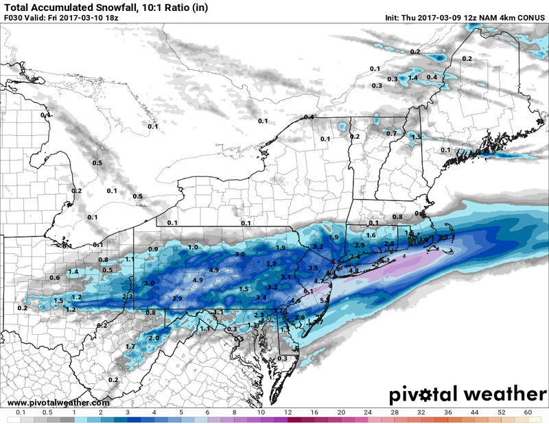

skinsfan1177- Senior Enthusiast
- Posts : 4485
Reputation : 35
Join date : 2013-01-07
Age : 46
Location : Point Pleasant Boro
Page 8 of 8 • 1, 2, 3, 4, 5, 6, 7, 8
Permissions in this forum:
You cannot reply to topics in this forum|
|
|