
 Search
March 14, 2017 Storm In Review
Page 1 of 3 • 1, 2, 3 ![]()

March 14, 2017 Storm In Review
![]() by Frank_Wx Tue Mar 14, 2017 8:41 pm
by Frank_Wx Tue Mar 14, 2017 8:41 pm
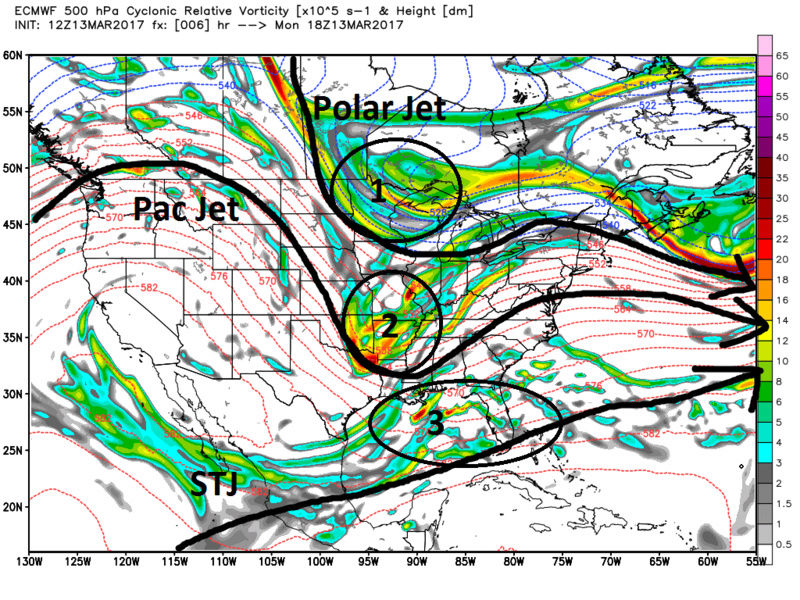
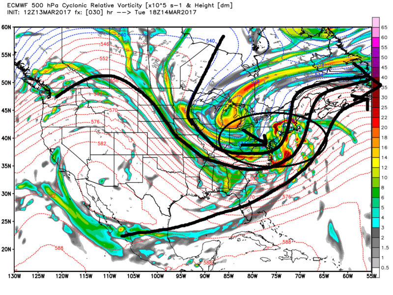
Clearly this storm did not go as planned for many forecasters. I said in one of the threads I do not make excuses for myself. Fact of the matter is, the NAO was positive, the upper level phasing was sloppy, there was a ridge over Newfoundland, and from a climo standpoint the month of March does not typically yield widespread Roidzilla type snowfall amounts. Upon further review it was pretty evident the writing was on the wall this one for the coastal plain. However, I am extremely happy for the interior since it seems they have missed out on being the bullseye with many storm events in the last few years. This set-up was RIPE for them.

In addition to the red flags mentioned, I also do not like the look of the mid level trough. It is situated too far west and the system itself amplified too quickly. 500mb did not close off likely due to the lack of confluence or blocking to our north. There was virtually NO cold air in the middle levels. A 50-50 Low would have helped us in that department.

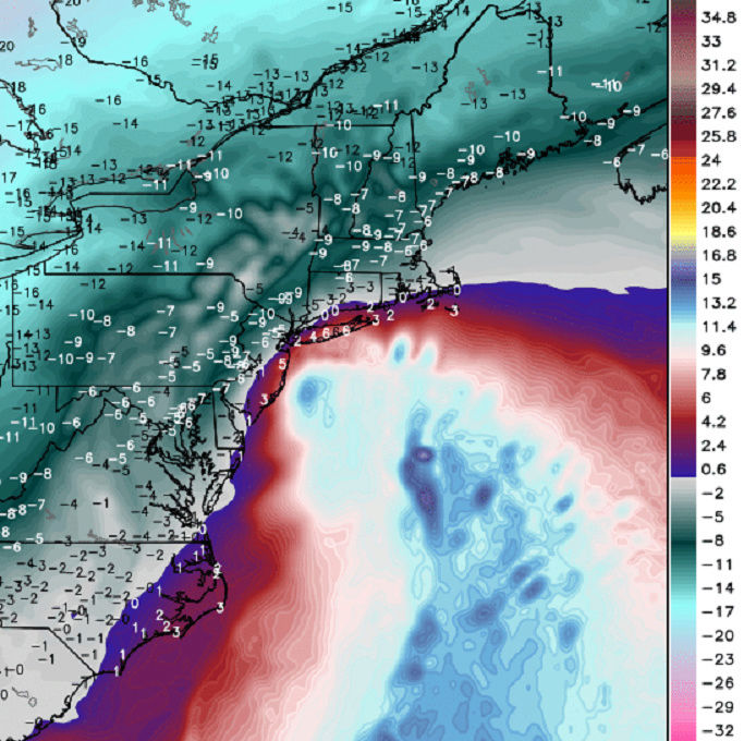
Lastly, the 700mb low tracked too far west. Lack of frontogenesis promoted lighter precip rates which limited dynamic cooling. This is why the mix line was able to advance so far N&W. It got into NW NJ and eastern PA at one point.

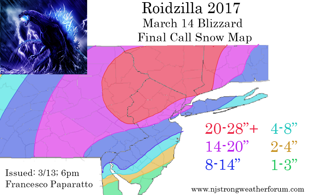
Overall, a disappointing forecast but one with lessons to take away. Everything needed to be shifted N&W by 50-75 miles. There is also something to be said about the modeling. I mean, the 00z EURO last night - which was consistent for the last 3 days - had the 850mb isotherm well off the coast. All the models did a horrific job with the temperatures. BUT, that is why good Mets do not use models. If we just looked at the 500mb pattern like I just did above, one should be able to deduce models were likely to bust.
Lastly - many new members joined the forum. We also set a record for the number of people browsing. I encourage all "guests" who are not registered and prefer to just read to register and join in on the discussions. You do not have to know anything about the weather. I promise. I use to have a setting on the forum where guests could not view any pictures I upload. Obviously I took it down because I want everyone to gain as much information and knowledge as possible while reading the content of NJ Strong. It's not just me who provides so many great forecasts. I can name at least 10 people. Welcome to the community!
Have a great night
Francesco Paparatto
_________________
_______________________________________________________________________________________________________
CLICK HERE to view NJ Strong Snowstorm Classifications

Frank_Wx- Godzilla Seeker

- Posts : 21305
Reputation : 328
Join date : 2013-01-05
Age : 31
Location : Jersey City, NJ -

Re: March 14, 2017 Storm In Review
![]() by mikeypizano Tue Mar 14, 2017 8:44 pm
by mikeypizano Tue Mar 14, 2017 8:44 pm

mikeypizano- Pro Enthusiast

- Posts : 1118
Reputation : 66
Join date : 2017-01-05
Age : 35
Location : Wilkes-Barre/Scranton, PA
Re: March 14, 2017 Storm In Review
![]() by CPcantmeasuresnow Tue Mar 14, 2017 8:50 pm
by CPcantmeasuresnow Tue Mar 14, 2017 8:50 pm
And speaking of the models last nights HRRRR had Red Sox Suck for 44 inches, they recieved 4.4 last I checked. Now that's a bad forecast.

CPcantmeasuresnow- Wx Statistician Guru

- Posts : 7274
Reputation : 230
Join date : 2013-01-07
Age : 103
Location : Eastern Orange County, NY
Re: March 14, 2017 Storm In Review
![]() by Guest Tue Mar 14, 2017 8:52 pm
by Guest Tue Mar 14, 2017 8:52 pm
Guest- Guest
Re: March 14, 2017 Storm In Review
![]() by track17 Tue Mar 14, 2017 8:52 pm
by track17 Tue Mar 14, 2017 8:52 pm
track17- Posts : 454
Reputation : 4
Join date : 2016-01-09
Re: March 14, 2017 Storm In Review
![]() by petep1000 Tue Mar 14, 2017 8:52 pm
by petep1000 Tue Mar 14, 2017 8:52 pm

petep1000- Posts : 35
Reputation : 0
Join date : 2016-01-18
Age : 65
Location : West Orange
Re: March 14, 2017 Storm In Review
![]() by algae888 Tue Mar 14, 2017 8:55 pm
by algae888 Tue Mar 14, 2017 8:55 pm

algae888- Advanced Forecaster

- Posts : 5311
Reputation : 46
Join date : 2013-02-05
Age : 61
Location : mt. vernon, new york
Re: March 14, 2017 Storm In Review
![]() by SENJsnowman Tue Mar 14, 2017 9:19 pm
by SENJsnowman Tue Mar 14, 2017 9:19 pm
Back on Jan 7, I was able to tell everyone I knew in the Ocean and Monmouth that we were about to get hit pretty hard. Most of the Shore who relied on the pro Mets had no idea until they woke up to the storm on Saturday morning what was happening.
This time around, you all knew a big storm was coming way before anyone was talking about and you knew the coast was going to have mixing issues. The Hour by Hour still shots you guys posted from the model runs for Sun and Mon told the story...SENJ was going to get pummelled with heavy rain almost from the start. I told all my local friends and neighbors "We aint getting the snow, no need to endure a run to ShopRite".
For me, the big lesson was this: LR models can tell you a storm is a-coming, SR models can give you a general idea of the track, and now-casting tells you what is actually going to happen and where.
Mother nature wouldn't have it any other way!
Great job and thanks again.
SENJsnowman- Senior Enthusiast

- Posts : 1186
Reputation : 61
Join date : 2017-01-06
Age : 51
Location : Bayville, NJ
Re: March 14, 2017 Storm In Review
![]() by jimv45 Tue Mar 14, 2017 9:20 pm
by jimv45 Tue Mar 14, 2017 9:20 pm
jimv45- Senior Enthusiast
- Posts : 1168
Reputation : 36
Join date : 2013-09-20
Location : Hopewell jct.
Re: March 14, 2017 Storm In Review
![]() by crippo84 Tue Mar 14, 2017 9:51 pm
by crippo84 Tue Mar 14, 2017 9:51 pm
I was slightly more disappointed in Nemo a few years back. That one exploded just a bit too late for the city while parts of LI received almost 3 feet in places.
Nothing takes the cake from Juno however. It was expected to be historic, potentially shattering the NYC snowfall record even the afternoon it had started snowing. Having never had experienced a major snowstorm, I was extremely disappointed with that bust. I think most of us were punched in the gut with that one. But last years unexpected record breaker made up for it for me anyway. Today's storm started trending out of our favor (coast-wise) starting early yesterday, if not earlier than that, so this one wasn't that upsetting. Again kudos to our forecasters here. I come here over any mainstream weather forecast.

crippo84- Posts : 383
Reputation : 20
Join date : 2013-11-07
Age : 40
Location : East Village, NYC
Re: March 14, 2017 Storm In Review
![]() by roccuweather Tue Mar 14, 2017 10:02 pm
by roccuweather Tue Mar 14, 2017 10:02 pm

roccuweather- Posts : 37
Reputation : 0
Join date : 2014-03-01
Location : Bradley Beach, NJ
Re: March 14, 2017 Storm In Review
![]() by jake732 Tue Mar 14, 2017 10:27 pm
by jake732 Tue Mar 14, 2017 10:27 pm

jake732- Pro Enthusiast
- Posts : 449
Reputation : 0
Join date : 2016-01-03
Location : lakewood, nj -
Re: March 14, 2017 Storm In Review
![]() by jmanley32 Tue Mar 14, 2017 10:39 pm
by jmanley32 Tue Mar 14, 2017 10:39 pm
WESTCHESTER COUNTY...
EASTCHESTER 15.2 855 PM 3/14 PUBLIC
JEFFERSON VALLEY 15.2 715 PM 3/14 TRAINED SPOTTER
DOBBS FERRY 15.0 447 PM 3/14 PUBLIC
SCARSDALE 15.0 519 PM 3/14 PUBLIC
SOMERS 14.5 423 PM 3/14 TRAINED SPOTTER
CROTON HEIGHTS 14.5 428 PM 3/14 PUBLIC
YORKTOWN HEIGHTS 14.5 442 PM 3/14 PUBLIC
MOUNT KISCO 14.2 515 PM 3/14 PUBLIC
IRVINGTON 14.0 306 PM 3/14 PUBLIC
BEDFORD 13.7 600 PM 3/14 TRAINED SPOTTER
ARMONK 12.4 948 PM 3/14 FIRE DEPT/RESCUE
MONTROSE 12.0 428 PM 3/14 TRAINED SPOTTER
KATONAH 11.0 504 PM 3/14 TRAINED SPOTTER
WHITE PLAINS 9.4 350 PM 3/14 TRAINED SPOTTER
PELHAM 8.8 200 PM 3/14 TRAINED SPOTTER
YONKERS 8.0 852 PM 3/14 TRAINED SPOTTER

jmanley32- Senior Enthusiast
- Posts : 20512
Reputation : 108
Join date : 2013-12-12
Age : 42
Location : Yonkers, NY
Re: March 14, 2017 Storm In Review
![]() by SoulSingMG Tue Mar 14, 2017 11:33 pm
by SoulSingMG Tue Mar 14, 2017 11:33 pm
jmanley32 wrote:Frank you did a great, tireless job no matter the outcome. The cutoff was amazing, this from NWS like Al said Eastchester NY recorded 15 inches while yonkers only 8, eastchester is a 10-15 min drive for me, its NOT far maybe less than 10 miles, and by trained spotters see below, the lowest amounts are southern westchester. Only one I think is wrong is white plains, they are well north and no way only got 9.4 I am over my seasonal average I cannot complain too much though I did earlier in a moment of frustration, the shoveling was back breaking, Yonkers schools are actually closed tomorrow too and the roads are still a mess, DOT has so far done a terrible job here.
WESTCHESTER COUNTY...
EASTCHESTER 15.2 855 PM 3/14 PUBLIC
JEFFERSON VALLEY 15.2 715 PM 3/14 TRAINED SPOTTER
DOBBS FERRY 15.0 447 PM 3/14 PUBLIC
SCARSDALE 15.0 519 PM 3/14 PUBLIC
SOMERS 14.5 423 PM 3/14 TRAINED SPOTTER
CROTON HEIGHTS 14.5 428 PM 3/14 PUBLIC
YORKTOWN HEIGHTS 14.5 442 PM 3/14 PUBLIC
MOUNT KISCO 14.2 515 PM 3/14 PUBLIC
IRVINGTON 14.0 306 PM 3/14 PUBLIC
BEDFORD 13.7 600 PM 3/14 TRAINED SPOTTER
ARMONK 12.4 948 PM 3/14 FIRE DEPT/RESCUE
MONTROSE 12.0 428 PM 3/14 TRAINED SPOTTER
KATONAH 11.0 504 PM 3/14 TRAINED SPOTTER
WHITE PLAINS 9.4 350 PM 3/14 TRAINED SPOTTER
PELHAM 8.8 200 PM 3/14 TRAINED SPOTTER
YONKERS 8.0 852 PM 3/14 TRAINED SPOTTER
Confident we got a solid 10/11" here in Port Chester, patted down by sleet galore. Nasty clearing process out there; everything is rock solid.
I feel like we're all holed up in a weather house on here during times of tracking these type of events, and some of us post more than others and certainly carry different levels of knowledge in weather, but I for one am thankful for this community (kudos, Frank), am proud to be learning from you all, and really appreciate the forum companionship in our shared obsession! :-)

SoulSingMG- Senior Enthusiast
- Posts : 2853
Reputation : 74
Join date : 2013-12-11
Location : Long Island City, NY
Re: March 14, 2017 Storm In Review
![]() by docstox12 Wed Mar 15, 2017 12:25 am
by docstox12 Wed Mar 15, 2017 12:25 am

docstox12- Wx Statistician Guru
- Posts : 8497
Reputation : 222
Join date : 2013-01-07
Age : 73
Location : Monroe NY
Re: March 14, 2017 Storm In Review
![]() by Sparky Sparticles Wed Mar 15, 2017 6:59 am
by Sparky Sparticles Wed Mar 15, 2017 6:59 am
Our final tally here in urban Hudson County was 5.8 inches, and of that, 3.4 was snow, the rest a mix of all the other crap that fell.
This morning, everything is SOLID ice. Already a number of cars on the block have tried to get out, and if their tires weren't completely encased in ice because they didn't shovel out yesterday, everything under and around them was solid ice with no traction, so their tires just kept spinning. One guy across the street from my apartment has been at it for over an hour, spinning, spinning, spinning. He slid into the car parked next to him twice and just kept trying to get out. He slid a bit in the other direction again so at least their cars are no longer touching, but there's no denying who made the dent in the guy's fender. So far the only vehicle I've seen actually driving down the street was a Jeep.

Sparky Sparticles- Posts : 124
Reputation : 1
Join date : 2014-02-11
Age : 70
Location : Bayonne, NJ
Re: March 14, 2017 Storm In Review
![]() by docstox12 Wed Mar 15, 2017 7:05 am
by docstox12 Wed Mar 15, 2017 7:05 am
Sparky Sparticles wrote:As soon as I woke up yesterday seeing the rain I knew the counts would be off. Then it started it's little cha-cha, going back and forth from normal snow, to sleet, to fat flakes, to rain, to super fine snow, to hail and sleet, to - - you get the picture.
Our final tally here in urban Hudson County was 5.8 inches, and of that, 3.4 was snow, the rest a mix of all the other crap that fell.
This morning, everything is SOLID ice. Already a number of cars on the block have tried to get out, and if their tires weren't completely encased in ice because they didn't shovel out yesterday, everything under and around them was solid ice with no traction, so their tires just kept spinning. One guy across the street from my apartment has been at it for over an hour, spinning, spinning, spinning. He slid into the car parked next to him twice and just kept trying to get out. He slid a bit in the other direction again so at least their cars are no longer touching, but there's no denying who made the dent in the guy's fender. So far the only vehicle I've seen actually driving down the street was a Jeep.
Just awful, and I have always said I would rather have plain rain than a slop storm like that.I got lucky because this storms more western track favored my area, the HV, with pure snow.Stay safe, Sir.
docstox12- Wx Statistician Guru
- Posts : 8497
Reputation : 222
Join date : 2013-01-07
Age : 73
Location : Monroe NY
Re: March 14, 2017 Storm In Review
![]() by Scullybutcher Wed Mar 15, 2017 7:46 am
by Scullybutcher Wed Mar 15, 2017 7:46 am

Scullybutcher- Pro Enthusiast
- Posts : 543
Reputation : 16
Join date : 2013-02-06
Location : North Smithtown, western Suffolk county, long island
Re: March 14, 2017 Storm In Review
![]() by devsman Wed Mar 15, 2017 8:11 am
by devsman Wed Mar 15, 2017 8:11 am

devsman- Pro Enthusiast
- Posts : 424
Reputation : 4
Join date : 2014-01-01
Age : 48
Location : merrick, ny (south shore of Long Island)
Re: March 14, 2017 Storm In Review
![]() by keliza52 Wed Mar 15, 2017 8:16 am
by keliza52 Wed Mar 15, 2017 8:16 am
Peace,
_______
Karen

keliza52- Posts : 51
Reputation : 0
Join date : 2013-12-08
Location : Hackettstown, NJ
Re: March 14, 2017 Storm In Review
![]() by Frank_Wx Wed Mar 15, 2017 8:43 am
by Frank_Wx Wed Mar 15, 2017 8:43 am
My favorite was the mid-day chat we did on Monday. That was SO much fun. I may have to do more of those in the future. I like them better than night one's.
_________________
_______________________________________________________________________________________________________
CLICK HERE to view NJ Strong Snowstorm Classifications
Frank_Wx- Godzilla Seeker
- Posts : 21305
Reputation : 328
Join date : 2013-01-05
Age : 31
Location : Jersey City, NJ -
Re: March 14, 2017 Storm In Review
![]() by sroc4 Wed Mar 15, 2017 9:06 am
by sroc4 Wed Mar 15, 2017 9:06 am


Seen a little differently


Unfort by the time the Polar jet began phasing the mid layer warm air surge had done its dirty work.

_________________
"In weather and in life, there's no winning and losing; there's only winning and learning."
WINTER 2012/2013 TOTALS 43.65"WINTER 2017/2018 TOTALS 62.85" WINTER 2022/2023 TOTALS 4.9"
WINTER 2013/2014 TOTALS 64.85"WINTER 2018/2019 TOTALS 14.25" WINTER 2023/2024 TOTALS 13.1"
WINTER 2014/2015 TOTALS 71.20"WINTER 2019/2020 TOTALS 6.35"
WINTER 2015/2016 TOTALS 35.00"WINTER 2020/2021 TOTALS 37.75"
WINTER 2016/2017 TOTALS 42.25"WINTER 2021/2022 TOTALS 31.65"

sroc4- Admin
- Posts : 8331
Reputation : 301
Join date : 2013-01-07
Location : Wading River, LI
Re: March 14, 2017 Storm In Review
![]() by billg315 Wed Mar 15, 2017 9:50 am
by billg315 Wed Mar 15, 2017 9:50 am

billg315- Advanced Forecaster - Mod

- Posts : 4461
Reputation : 185
Join date : 2015-01-24
Age : 50
Location : Flemington, NJ
Re: March 14, 2017 Storm In Review
![]() by Dtone Wed Mar 15, 2017 11:38 am
by Dtone Wed Mar 15, 2017 11:38 am
devsman wrote:Just got to work in Flushing Queens. These roads are the worst of seen here in any storm. I had to park half mile away from my school. Every car is trapped in ice. Deblasio did a horrible job. Cars are stranded in the street. Bad bad job NYC.
Yeah it is bad. To be fair I think its more the nature of sleet compared to snow then anything the city could of done.
Just b/c there wasn't epic snow totals closer to the coast doesn't mean it wasn't a impactful storm. I would of had a easier time with 2 feet of pure snow than a foot of sleet. It sucks.
I have co workers from LI and they were shocked at the acclumations once they crossed the Whitestone.
Dtone- Wx Statistician Guru
- Posts : 1738
Reputation : 9
Join date : 2013-08-26
Location : Bronx, NY
Re: March 14, 2017 Storm In Review
![]() by Frank_Wx Wed Mar 15, 2017 11:51 am
by Frank_Wx Wed Mar 15, 2017 11:51 am
billg315 wrote:I posted a story in banter, because I think its a better place for the discussion. But I would love to get people's thoughts/reactions because I found it stunning. The story I posted in Banter is an A.P. story where the NWS acknowledges thinking their prediction was overdone Monday afternoon, but not adjusting the totals downward because they wanted people to be prepared anyway. It's the first time I remember the NWS admitting they left a forecast out there they didn't really believe in, to achieve a "preparedness" goal. I submit, (and I really do respect these guys and the tough work they do) that for their credibility alone, as well as scientific honesty, this was a mistake.
Agree it was a mistake. The purpose of an accurate forecast is to gain the trust of the general public. When the next storm comes around, maybe less people will take their forecast seriously. Don't these guys have a way to measure their performance? If, say, at the end of the year you have an 85% accuracy but your goal is 90%, then you're hurting yourself personally too. I just do not understand that logic.
_________________
_______________________________________________________________________________________________________
CLICK HERE to view NJ Strong Snowstorm Classifications
Frank_Wx- Godzilla Seeker
- Posts : 21305
Reputation : 328
Join date : 2013-01-05
Age : 31
Location : Jersey City, NJ -
Page 1 of 3 • 1, 2, 3 ![]()
|
|
|