
 Search
2017-18 Winter Discussion thread
Page 3 of 6 •  1, 2, 3, 4, 5, 6
 ![]()
Re: 2017-18 Winter Discussion thread
![]() by algae888 Tue Oct 03, 2017 8:53 pm
by algae888 Tue Oct 03, 2017 8:53 pm
algae888- Advanced Forecaster

- Posts : 5311
Join date : 2013-02-05
Re: 2017-18 Winter Discussion thread
![]() by sroc4 Tue Oct 03, 2017 9:39 pm
by sroc4 Tue Oct 03, 2017 9:39 pm
algae888 wrote:this is not a nina att. pac still very warm. even if nina does develop will it be to late to affect winter esp early winter...
major warming taking place...
i think we can forget a moderate nina . weak maybe. we shall see.

Al keep in mind there is a lot more than just the surface temps when evaluating if this Nina is coming or not. The SOI has been screaming positive for about 10 days with at least another 3-5days of the same.
https://www.longpaddock.qld.gov.au/seasonalclimateoutlook/southernoscillationindex/30daysoivalues/
In addition the subsurface temps have been building. With continued prominent easterly's as seen by the SOI these subsurface temps will cont to come up and propagate westward on the surface. Weak or Mod Nina is looking more and more likely as we head further into the fall. Notice between Sept 16th and the 21st we had a neg burst on the SOI. And notice the dates the turn on the Nino region graphs turned towards positive. About 7-10days post neg burst. I can almost guarantee those tropical tidbit maps and graphs will be trending back towards negative and colder anomalies within the next week to ten days from now if not sooner.
sroc4- Admin

- Posts : 8331
Join date : 2013-01-07
Re: 2017-18 Winter Discussion thread
![]() by algae888 Tue Oct 03, 2017 10:12 pm
by algae888 Tue Oct 03, 2017 10:12 pm

algae888- Advanced Forecaster
- Posts : 5311
Reputation : 46
Join date : 2013-02-05
Age : 61
Location : mt. vernon, new york
Re: 2017-18 Winter Discussion thread
![]() by HectorO Tue Oct 03, 2017 10:15 pm
by HectorO Tue Oct 03, 2017 10:15 pm

HectorO- Pro Enthusiast

- Posts : 959
Reputation : 27
Join date : 2013-01-11
Re: 2017-18 Winter Discussion thread
![]() by algae888 Wed Oct 04, 2017 8:16 am
by algae888 Wed Oct 04, 2017 8:16 am
hector weather is all about probabilities. the probability of a cold and snowy winter goes up with weak enso but like you said bad winters do happen within weak enso as other factors also play a role in our weather. this it what makes weather esp winter weather so fascinating! which will drive our winter pattern this year? ENSO, PDO, AO,NAO, EPO, QBO, MJO, just to name a few.HectorO wrote:This is where it gets confusing. People complain about la niña and people complain about El Nino. Just which is it that helps us out? I've seen bad winters with both in place.
algae888- Advanced Forecaster
- Posts : 5311
Reputation : 46
Join date : 2013-02-05
Age : 61
Location : mt. vernon, new york
Re: 2017-18 Winter Discussion thread
![]() by algae888 Wed Oct 04, 2017 9:26 am
by algae888 Wed Oct 04, 2017 9:26 am
algae888- Advanced Forecaster
- Posts : 5311
Reputation : 46
Join date : 2013-02-05
Age : 61
Location : mt. vernon, new york
Re: 2017-18 Winter Discussion thread
![]() by algae888 Wed Oct 04, 2017 9:35 am
by algae888 Wed Oct 04, 2017 9:35 am
algae888- Advanced Forecaster
- Posts : 5311
Reputation : 46
Join date : 2013-02-05
Age : 61
Location : mt. vernon, new york
Re: 2017-18 Winter Discussion thread
![]() by algae888 Wed Oct 04, 2017 9:39 am
by algae888 Wed Oct 04, 2017 9:39 am

dec 2010

current
algae888- Advanced Forecaster
- Posts : 5311
Reputation : 46
Join date : 2013-02-05
Age : 61
Location : mt. vernon, new york
Re: 2017-18 Winter Discussion thread
![]() by algae888 Wed Oct 04, 2017 9:49 am
by algae888 Wed Oct 04, 2017 9:49 am

algae888- Advanced Forecaster
- Posts : 5311
Reputation : 46
Join date : 2013-02-05
Age : 61
Location : mt. vernon, new york
Re: 2017-18 Winter Discussion thread
![]() by algae888 Wed Oct 04, 2017 10:32 am
by algae888 Wed Oct 04, 2017 10:32 am


algae888- Advanced Forecaster
- Posts : 5311
Reputation : 46
Join date : 2013-02-05
Age : 61
Location : mt. vernon, new york
Re: 2017-18 Winter Discussion thread
![]() by amugs Wed Oct 04, 2017 10:43 am
by amugs Wed Oct 04, 2017 10:43 am
84-85 IMO was a good winter and I remember it vividly since we froze in late Jan through late February and had a nice glacier then too.algae888 wrote:2010/2011 last mod nina we had a fantastic winter 61.9" of snow. similarities- nina did not hit moderate levels until mid winter (assuming we get to mod. this year), however we were coming out of a moderate nino. not a good match IMO. 67/68 and better yet 84/85 seem to match our current enso. not good years for snow lovers however both of those years had an early start to winter....
Mod Nina in 2010-11 was great due to the fact we had very low solar and massive blocking with a permanent N AO basically that winter.
Some analog years: 67-68 a good analog maybe teh best at this point - Mod to High N QBO, N to COLD PDO, ENSO -.5 to -.5.

Other years: ENSO-PDO-QBO combo (55, 65, 71, 75, 96, 01, 06) Of note 6 of these 7 years featured a neg AO and NAO.

Time will tell and we have to see how the next 6-7 weeks shape up for this
_________________
Mugs
AKA:King: Snow Weenie
Self Proclaimed
WINTER 2014-15 : 55.12" +.02 for 6 coatings (avg. 35")
WINTER 2015-16 Total - 29.8" (Avg 35")
WINTER 2016-17 : 39.5" so far

amugs- Advanced Forecaster - Mod

- Posts : 15091
Reputation : 213
Join date : 2013-01-07
Age : 54
Location : Hillsdale,NJ
Re: 2017-18 Winter Discussion thread
![]() by algae888 Wed Oct 04, 2017 11:48 am
by algae888 Wed Oct 04, 2017 11:48 am
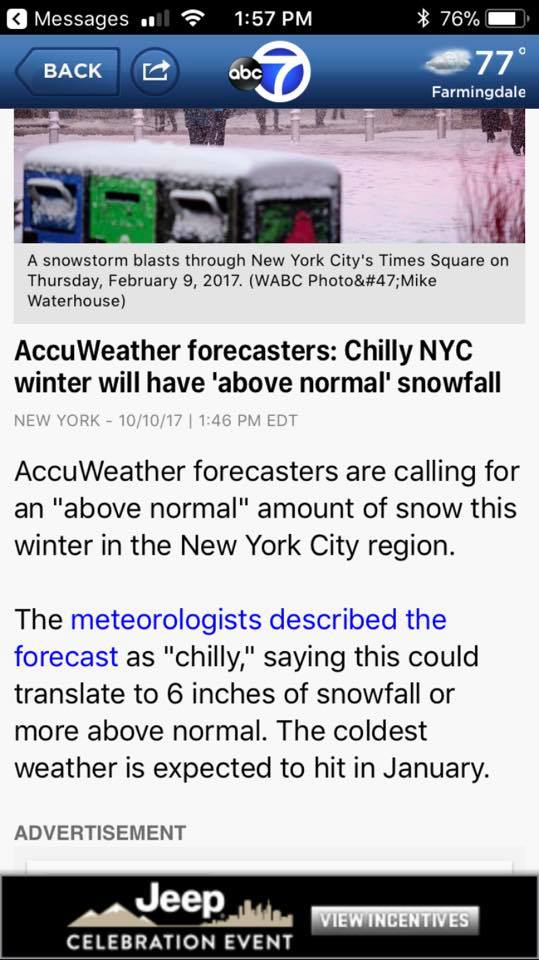
https://www.accuweather.com/en/weather-news/2017-2018-us-winter-forecast/70002894
here is an part of there forecast...
Cold and snow to strike Northeast, mid-Atlantic
A chilly winter is in store for the Northeast and mid-Atlantic, particularly when compared to last year. For most of both regions, this will translate to an above-normal snow season.
“Areas in the I-95 corridor will average close to normal, within a few inches,” AccuWeather Lead Long-Range Forecaster Paul Pastelok said. “Areas away from the I-95 corridor have a better chance at a big snowfall.”
New York City and Red Sox Suck, Massachusetts, may be the exceptions to this, with early predictions calling for 6 inches of snowfall or more above normal in both cities.
algae888- Advanced Forecaster
- Posts : 5311
Reputation : 46
Join date : 2013-02-05
Age : 61
Location : mt. vernon, new york
Re: 2017-18 Winter Discussion thread
![]() by Frank_Wx Wed Oct 04, 2017 2:17 pm
by Frank_Wx Wed Oct 04, 2017 2:17 pm
It will be interesting to see how La Nina and the MJO may try to influence our winter weather pattern too. Lots to watch out for.
_________________
_______________________________________________________________________________________________________
CLICK HERE to view NJ Strong Snowstorm Classifications

Frank_Wx- Godzilla Seeker
- Posts : 21305
Reputation : 328
Join date : 2013-01-05
Age : 31
Location : Jersey City, NJ -

Re: 2017-18 Winter Discussion thread
![]() by sroc4 Wed Oct 04, 2017 4:06 pm
by sroc4 Wed Oct 04, 2017 4:06 pm
Frank_Wx wrote:My big take away for winter at this time is we're headed to solar minimum with an easterly QBO already established. I personally believe that raises the probability of a sudden stratospheric warming event occurring sometime in January or early February. Furthermore, blocking in the Barents-Kara seas and negative height anomalies across Siberia favor a positive SAI (snow advanced index) though all of October. Statistically that means our AO this winter could be negative and the Polar Vortex will be in a weakened state, further adding credence to a possible SSWE taking place.
It will be interesting to see how La Nina and the MJO may try to influence our winter weather pattern too. Lots to watch out for.
Great points Frank. We have to hope that the SSWE doesnt occur too early this season like it did last year. Recall the warming event we had in mid to late Oct last year that gave us some snow for areas off the coast around Turkey day the in first half of Dec. By Jan the Strat vortex re strengthened and was a problem for the rest of the winter., But like you said we have an easterly QBO rather than a strengthening westerly QBO like we had throughout last winter.
_________________
"In weather and in life, there's no winning and losing; there's only winning and learning."
WINTER 2012/2013 TOTALS 43.65"WINTER 2017/2018 TOTALS 62.85" WINTER 2022/2023 TOTALS 4.9"
WINTER 2013/2014 TOTALS 64.85"WINTER 2018/2019 TOTALS 14.25" WINTER 2023/2024 TOTALS 13.1"
WINTER 2014/2015 TOTALS 71.20"WINTER 2019/2020 TOTALS 6.35"
WINTER 2015/2016 TOTALS 35.00"WINTER 2020/2021 TOTALS 37.75"
WINTER 2016/2017 TOTALS 42.25"WINTER 2021/2022 TOTALS 31.65"

sroc4- Admin
- Posts : 8331
Reputation : 301
Join date : 2013-01-07
Location : Wading River, LI
Re: 2017-18 Winter Discussion thread
![]() by weatherwatchermom Thu Oct 05, 2017 5:42 pm
by weatherwatchermom Thu Oct 05, 2017 5:42 pm
amugs wrote:Tom,
So true and the 500MB set up is ideal the brings us an early winter as some wold coin it starting in Mid Nov. Lots of High Latitude blocking for Omega and Banana High along with the elusive but famous Greenland block. I would sign with my blood right now for a winter that is being advertised right now by the EURO. We all things can change. Time will certainly tell.
SNOW FORECAST
500MB set up
Precip WOW
TEMPS - Feb skews the Nov - Jan cold which is about 2* BN
Enjoy this eye candy!
.png)
.png)
I would take this after the last couple of winters...where do I sign...

weatherwatchermom- Senior Enthusiast

- Posts : 3729
Reputation : 77
Join date : 2014-11-25
Age : 60
Location : Hazlet Township, NJ
Re: 2017-18 Winter Discussion thread
![]() by sroc4 Sat Oct 07, 2017 9:06 am
by sroc4 Sat Oct 07, 2017 9:06 am
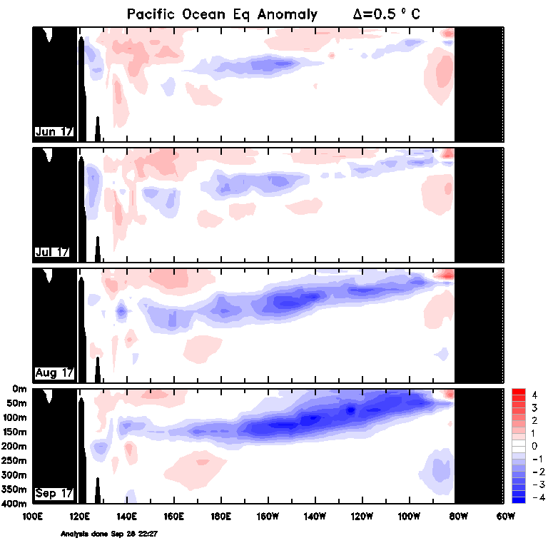
algae888 wrote:Yes scott i have seen and been momitoring the sub surface temps. While steadily cooling i do not think it will cool a very warm pacific to modetate nina levels. Point is that we are not even close to an official nina (3 months of -.5 ot greater sst.)Even if pac cooled to that level noaa will not classify nina until jan at earliest if i am not mistaken. So my thinking and question is how much of an effect will the cooling pac have on our early winter season. Mid nov to jan 1st. Obviously we can have nina like conditions even if we are not in a nina however my feeling att is that nina like conditions may not be constant for first part of winter.
Al you are correct as far as defining an official La Nina. I believe the NWS defines it as having an ONI (Oceanic Nino Index - 3month avg) of Less than or equal to -0.5 for 5 consecutive months. For those who don't know what this is click here: http://origin.cpc.ncep.noaa.gov/products/analysis_monitoring/ensostuff/ONI_v5.php The latest ONI for the (July/Aug/Sept) is in at -0.1, still neutral so if we assume Oct reaches -0.5 then an official Nina wont be defined until Feb. But the atmospheric effects will have been felt before then should current Trop Pac conditions persist.
So my thinking and question is how much of an effect will the cooling pac have on our early winter season. This is a great question Al; one that will be answered for us soon enough. Recall our convo from Oct 3rd. As you can see the current strong positive SOI has now triggered the turn back towards the negative as anticipated.


How low will this latest SOI positive burst take us in the various Nino regions we shall see. Looking at the short and medium range Equatorial Pac MSLP anomalies it doesn't look like the SOI is going to dip any time soon either, so I anticipate a decent drop in those graphs above for the next 2 weeks or so.
https://www.longpaddock.qld.gov.au/seasonalclimateoutlook/southernoscillationindex/30daysoivalues/
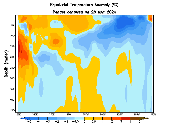
Interesting to look at the Sub surface temps from this year compared to this time last year.
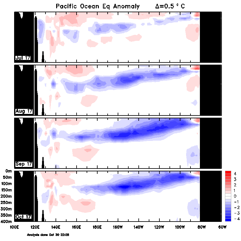
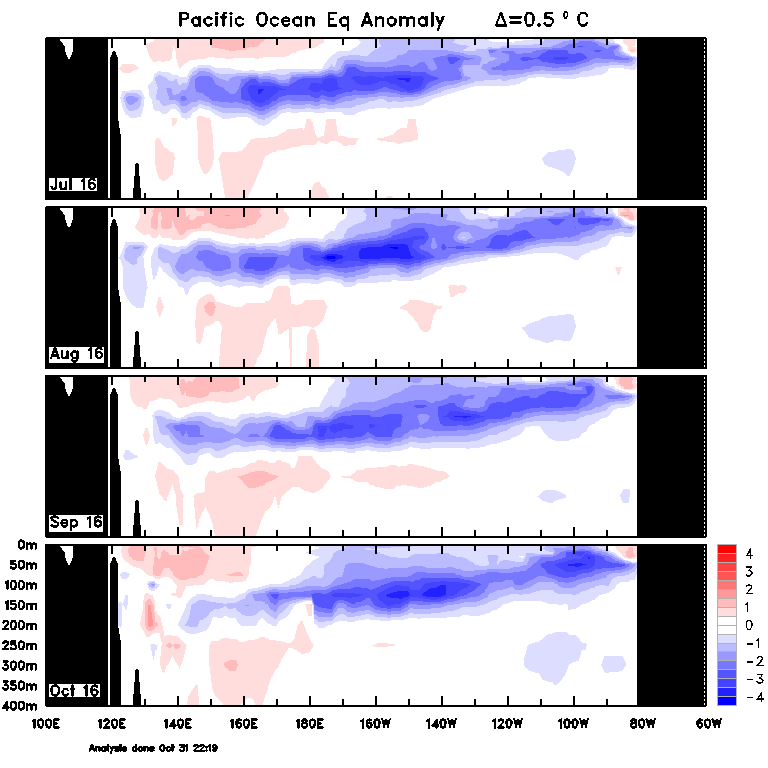
Not all that dissimilar with the exception of July where the colder anomalies were much stronger last year vs this year. Now look at last year July 2016 through Jan 2017. Notice that by January the subsurface temps had backed off big time.
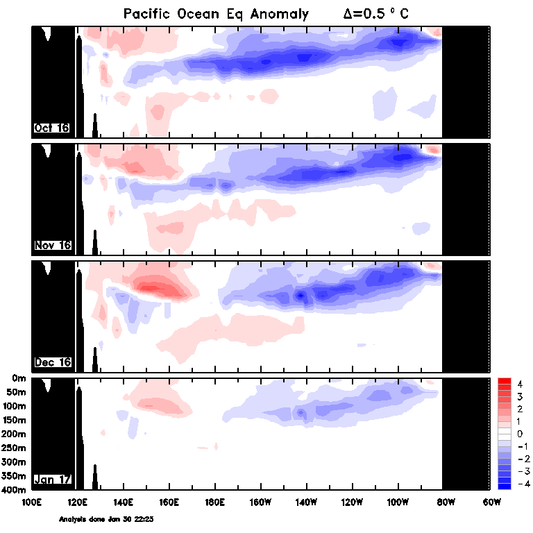
So what happens to the SST in the Trop Pac this year through Jan? Well. Currently we are in a very strong persistent positive burst of the SOI. This would mean that for the up coming few weeks we should cont to see the trend towards neg regarding the SSTA in the Nino regions. If we look at the trend of the SOI Monthly from last year this time to this year you'll notice that there was a rapid drop to the SOI (weakening of the easterlies) headed into Oct followed by a neutral SOI Monthly between Nov-Feb. However; This year we are currently not seeing the same trend towards a neg SOI, but instead a positive one. At least for the foreseeable future. This tells me that the La Nina will cont to progress, at least for now, before backing off. When it backs off is still debatable at this point. So for me the trends cont to point towards a weak to Mod La Nina for our winter, but obv much can change between now and then. ENSO status is only one driver that will influence the outcome of our winter. Last year the Strat PV centered itself over the Asian side of the N Hemisphere and that was hugely influential as to why we were so stinking warm. This year we have a very different QBO (easterly) vs the strong +QBO(westerly) this year. Interesting times ahead.

_________________
"In weather and in life, there's no winning and losing; there's only winning and learning."
WINTER 2012/2013 TOTALS 43.65"WINTER 2017/2018 TOTALS 62.85" WINTER 2022/2023 TOTALS 4.9"
WINTER 2013/2014 TOTALS 64.85"WINTER 2018/2019 TOTALS 14.25" WINTER 2023/2024 TOTALS 13.1"
WINTER 2014/2015 TOTALS 71.20"WINTER 2019/2020 TOTALS 6.35"
WINTER 2015/2016 TOTALS 35.00"WINTER 2020/2021 TOTALS 37.75"
WINTER 2016/2017 TOTALS 42.25"WINTER 2021/2022 TOTALS 31.65"
sroc4- Admin
- Posts : 8331
Reputation : 301
Join date : 2013-01-07
Location : Wading River, LI
Re: 2017-18 Winter Discussion thread
![]() by algae888 Mon Oct 09, 2017 5:45 am
by algae888 Mon Oct 09, 2017 5:45 am
algae888- Advanced Forecaster
- Posts : 5311
Reputation : 46
Join date : 2013-02-05
Age : 61
Location : mt. vernon, new york
Re: 2017-18 Winter Discussion thread
![]() by sroc4 Mon Oct 09, 2017 8:17 am
by sroc4 Mon Oct 09, 2017 8:17 am
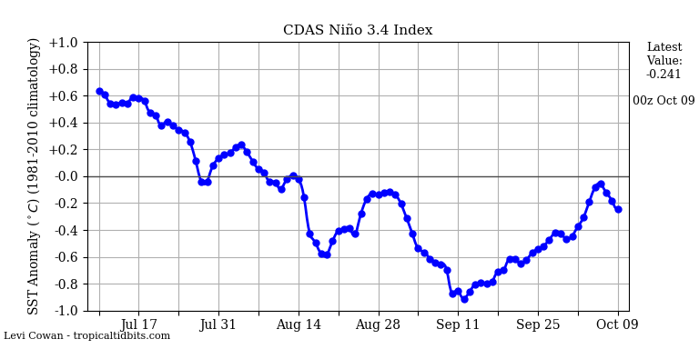
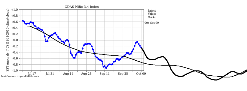
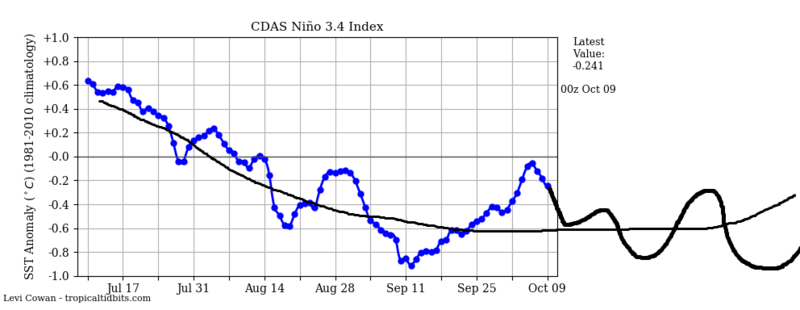
algae888 wrote:Scott even though the Soi is positive the only region significantly dropping is 1.2. Region 4 has started to warm and Region 3 and 3.4 look to be leveling off. Also take a look at National Weather Service subsurface Temps there is no cold pool east of the Date Line and even the cold pool off the South American Coast has now shown signs of warming. I'm calling for a la nina in only region 1.2 the rest of the enso cold neutral for this winter.
Al Nino 1.2 is such a shallow section of water in the Trop Pac that its temp changes cannot be interpreted in the big picture. It is highly volatile and can change very very rapidly; therefore up or down is insignificant when looking at the big picture of ENSO. Nino 1.2 will likely have several mood swings throughout the season and be up and down more rapidly than any other region.
Regarding ENSO its Nino 3.4 that "officially" characterizes the ENSO status, but Nino 3 and Nino 4 of course play a role in the big picture (east based, west based vs entire region etc.). At the present there is simply no way to say with any certainty if any of these regions(4, 3.4 or 3) are continuing to cool, or are truly leveling off. Things like SST changes in such large deep regions; then the delayed effects of said changes on the atmosphere, cannot be looked at on such a small time scale. In a few months from now we will be able to look back on early Oct to know if this time frame was truly the leveling off of the SSTA.
Temp Changes in Nino 1.2 and the long term effects on the atmosphere in the long run are analogous to a knee jerk reflex reaction from the hammer on the patellar ligament and trying to build muscle from the knee jerk reflex alone; whereas, the changes in the other regions are analogous to going to the gym every day and running and lifting weights. How consistent and how intense your work out is dictates the results of the work out. But the end results on the body come mid-late winter will be dictated by the consistency and type of the work outs throughout the entire time frame; not how good or bad a work out is on any given week or even month. High weights with low reps builds muscle quickly but not endurance. Lower weights and higher reps builds the size of the muscle slower, but builds endurance for the muscle group. Obv up through this time frame the work outs have been fairly consistent and the trop Pac has been slowly building muscle towards a weak La Nina or neutral conditions, but what happens over the next 2-3 months will really dictate the end result. Yes if we are truly leveling off right now then the end result will be a Neutral winter to maybe a weak La Nina at best, but the effects of the current status of the SOI(strength of the easterlies in the Trop Pac), the full effects of which, will not be seen for a few weeks. And if we cont to get these positive bursts overall throughout the remainder of the Fall we will likely continue towards weak to mod La nina territory. One thing is for certain is that over all the warmer anomalies over the Western Pac (nino 4) have trended cooler and since the summer. The remainder of the Nino regions have done the same over all.

Al is def correct in that there has been a subtle change overall to the intensity of the sub surface temps and there has been what appears to be a leveling off to the cooling of the Nino regions. However; was the more recent changes because we had a run of weakly neg to neutral SOI (slowing of the easterlies in trop Pac) in early to mid Sept, combined with an active Topical Atlantic basin causing the Walker Cell/Hadley Cell configuration shift such that we had a warming trend? With the Atlantic basin quieting down do we resume our work outs towards La Nina, or have we really leveled off? Questions that simply cannot be answered at the moment. The next CPC discussion on ENSO status will come out late this week or early next week.
_________________
"In weather and in life, there's no winning and losing; there's only winning and learning."
WINTER 2012/2013 TOTALS 43.65"WINTER 2017/2018 TOTALS 62.85" WINTER 2022/2023 TOTALS 4.9"
WINTER 2013/2014 TOTALS 64.85"WINTER 2018/2019 TOTALS 14.25" WINTER 2023/2024 TOTALS 13.1"
WINTER 2014/2015 TOTALS 71.20"WINTER 2019/2020 TOTALS 6.35"
WINTER 2015/2016 TOTALS 35.00"WINTER 2020/2021 TOTALS 37.75"
WINTER 2016/2017 TOTALS 42.25"WINTER 2021/2022 TOTALS 31.65"
sroc4- Admin
- Posts : 8331
Reputation : 301
Join date : 2013-01-07
Location : Wading River, LI

Snow88- Senior Enthusiast
- Posts : 2193
Reputation : 4
Join date : 2013-01-09
Age : 35
Location : Brooklyn, NY
Re: 2017-18 Winter Discussion thread
![]() by HectorO Tue Oct 10, 2017 4:23 pm
by HectorO Tue Oct 10, 2017 4:23 pm
Snow88 wrote:
As opposed to our annual January thaw lol.
HectorO- Pro Enthusiast
- Posts : 959
Reputation : 27
Join date : 2013-01-11
Re: 2017-18 Winter Discussion thread
![]() by sroc4 Thu Oct 12, 2017 2:20 pm
by sroc4 Thu Oct 12, 2017 2:20 pm
Click the link for the full discussion: http://www.cpc.ncep.noaa.gov/products/analysis_monitoring/enso_advisory/ensodisc.pdf
Synopsis: La Niña conditions are favored (~55-65%) during the Northern Hemisphere fall and
winter 2017-18.
During September, ENSO-neutral conditions were reflected in near-to-below average sea surface
temperatures (SSTs) across most of the central and eastern Pacific Ocean (Fig. 1). The weekly Niño
indices were volatile during the month, with negative values increasing to near zero during the past week
in the Niño-4, Niño-3.4, and Niño-3 regions (Fig. 2). In contrast, sub-surface temperature anomalies were
increasingly negative during September (Fig. 3), reflecting the shallow depth of the thermocline across
the central and eastern Pacific (Fig. 4). Also, convection was suppressed near the International Date Line
and enhanced near Indonesia (Fig. 5). Over the western equatorial Pacific Ocean, low-level trade winds
were anomalously easterly and upper-level winds were anomalously westerly. Overall, the ocean and
atmosphere system remains consistent with ENSO-neutral, although edging closer to La Niña conditions.
For the upcoming Northern Hemisphere fall and winter 2017-18, a weak La Niña is favored in the
dynamical model averages of the IRI/CPC plume (Fig. 6) and North American Multi-Model Ensemble
(NMME) (Fig. 7). Several models indicate a period of near-average Niño-3.4 values in the upcoming
weeks, but then predict reinvigorated growth of negative SST anomalies across the equatorial Pacific
Ocean. These forecasts are supported by the ongoing easterly wind anomalies across portions of the
Pacific Ocean and the reservoir of below-average subsurface temperatures. In summary, La Niña
conditions are favored (~55-65%) during the Northern Hemisphere fall and winter 2017-18 (click
CPC/IRI consensus forecast for the chance of each outcome for each 3-month period).
Here is the graph for the various ENSO climate prediction models. Notice the one that is most negative. It is the NCEP CFS v2. The line on this graph represents the ensemble mean.
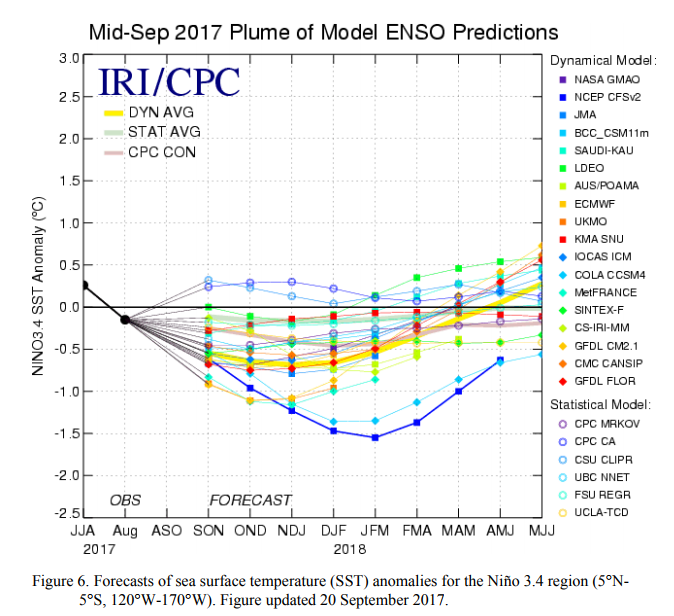
Here is the NCEP CFS v2 website and the last 16 forecasts. With blue lines representing the 8 most recent runs. Notice the last 8 runs lean more negative. That doesnt necesarilly mena anything yet as it has jumped around; however, I would like to point out that this particular model in the late spring time frame was the first one to catch on to the idea that the possible return to El Nino status for the time frame we are in now was not going to happen and began showing the ENSO go back into the negative territory as we approached Fall. It has consistently throughout the summer slowly trended more negative. Again whether it ends up right about the intensity of this oncoming La Nina is far from certain at this stage, but something to raise an eyebrow, because again the stronger the La Nina the more robust the influences it will have on the big picture for the winter. Statistics favor a milder winter in the east the stronger the La Nina is; however, we had mod La Ninas and still had great winters. Obv all the other drivers/pattern enhancers still need to be plugged into such an equation when determining the final result.

_________________
"In weather and in life, there's no winning and losing; there's only winning and learning."
WINTER 2012/2013 TOTALS 43.65"WINTER 2017/2018 TOTALS 62.85" WINTER 2022/2023 TOTALS 4.9"
WINTER 2013/2014 TOTALS 64.85"WINTER 2018/2019 TOTALS 14.25" WINTER 2023/2024 TOTALS 13.1"
WINTER 2014/2015 TOTALS 71.20"WINTER 2019/2020 TOTALS 6.35"
WINTER 2015/2016 TOTALS 35.00"WINTER 2020/2021 TOTALS 37.75"
WINTER 2016/2017 TOTALS 42.25"WINTER 2021/2022 TOTALS 31.65"
sroc4- Admin
- Posts : 8331
Reputation : 301
Join date : 2013-01-07
Location : Wading River, LI
Re: 2017-18 Winter Discussion thread
![]() by algae888 Thu Oct 12, 2017 8:38 pm
by algae888 Thu Oct 12, 2017 8:38 pm


day 10 ridge starting to build out west. by day 15 look at what we have....


nice -nao showing up. that is a cold and snowy pattern in winter. let's hope it holds and continues for winter.
algae888- Advanced Forecaster
- Posts : 5311
Reputation : 46
Join date : 2013-02-05
Age : 61
Location : mt. vernon, new york
Re: 2017-18 Winter Discussion thread
![]() by devsman Thu Oct 12, 2017 9:04 pm
by devsman Thu Oct 12, 2017 9:04 pm

devsman- Pro Enthusiast
- Posts : 424
Reputation : 4
Join date : 2014-01-01
Age : 48
Location : merrick, ny (south shore of Long Island)
Re: 2017-18 Winter Discussion thread
![]() by rb924119 Thu Oct 12, 2017 9:35 pm
by rb924119 Thu Oct 12, 2017 9:35 pm
rb924119- Meteorologist

- Posts : 6888
Reputation : 194
Join date : 2013-02-06
Age : 32
Location : Greentown, Pa
Re: 2017-18 Winter Discussion thread
![]() by docstox12 Fri Oct 13, 2017 5:19 am
by docstox12 Fri Oct 13, 2017 5:19 am
devsman wrote:Lee Goldberg said today that he expects normal temps for the winter with above normal snowfall. Here's to hoping.
Don't know what Lee's source is to base this forecast on but I do respect him as a Meteorologist who is very accurate, so I hope this long range prediction is true.

docstox12- Wx Statistician Guru

- Posts : 8497
Reputation : 222
Join date : 2013-01-07
Age : 73
Location : Monroe NY
Re: 2017-18 Winter Discussion thread
![]() by amugs Fri Oct 13, 2017 7:38 am
by amugs Fri Oct 13, 2017 7:38 am
rb924119 wrote:As we've seen every winter season in my working memory, should be taken with hesitation (just as a warning, my memory is horrible lmao) models do tend to rush the true pattern changes. While it looks good now, I think what we see now for day ten and beyond will ultimately be transient, as much as I hate to admit.
Pattern is going more towards normal as we moved beyond next weekend from the looks as of now of course. Of course we will be transient to a degree as we try to shake out all of this tropical air that these beasts have transported up this way fro the last 6-7 weeks and we have a pig belly trough stuck up in teh GOA.
Reasons why what I showed back in the beginning of OCtober for a mid month change to more normal and the trough sticking aorund in teh NE as we had this past summer was the hcane brigade which could be directly related to the MJO phase 2, Nina state in the EPAC, Low shear and boiling Hotlantic and the SOI going to SD 9 which is way AN from its normal range. As does with weather it takes time to shake things out so to speak. A recurving typhoon will help but the pig eyed AL LP looks to be pulling back.
Also my and everyone else's favorite - solar, the sun that is - was VERY active during the stretch as well but has since calmed down to nill which will help with HL blocking over teh top.
Time will tell and I am sure a Zito curve ball from his prime will be thrown into teh mix!
_________________
Mugs
AKA:King: Snow Weenie
Self Proclaimed
WINTER 2014-15 : 55.12" +.02 for 6 coatings (avg. 35")
WINTER 2015-16 Total - 29.8" (Avg 35")
WINTER 2016-17 : 39.5" so far
amugs- Advanced Forecaster - Mod
- Posts : 15091
Reputation : 213
Join date : 2013-01-07
Age : 54
Location : Hillsdale,NJ
Re: 2017-18 Winter Discussion thread
![]() by algae888 Sat Oct 14, 2017 6:45 pm
by algae888 Sat Oct 14, 2017 6:45 pm
if enso doesn't cool drastically the next few weeks esp nino 3.4 and 4 we are looking at a muted enso and pdo (which warmed in September but now cooling) both of which will have less impact on our sensible weather and allow other factors like the strat soi mjo to name a few to have more influence on our weather. throw in the very warm waters in the north atlantic which could help with the nao domain, lead me to believe that we could be in for a nice winter if you like cold and snow. right now I see no glaring issues unless of course nina gets to moderate or the pdo tanks. nina winters usually start early (front loaded) so get ready for the ride people.
algae888- Advanced Forecaster
- Posts : 5311
Reputation : 46
Join date : 2013-02-05
Age : 61
Location : mt. vernon, new york
Page 3 of 6 • 1, 2, 3, 4, 5, 6 ![]()