
 Search
Tracking Hurricane Irma
Page 20 of 35 •  1 ... 11 ... 19, 20, 21 ... 27 ... 35
 ![]()
Re: Tracking Hurricane Irma
![]() by SoulSingMG Mon Sep 04, 2017 7:32 am
by SoulSingMG Mon Sep 04, 2017 7:32 am
SoulSingMG- Senior Enthusiast

- Posts : 2853
Join date : 2013-12-11
Re: Tracking Hurricane Irma
![]() by sroc4 Mon Sep 04, 2017 7:36 am
by sroc4 Mon Sep 04, 2017 7:36 am

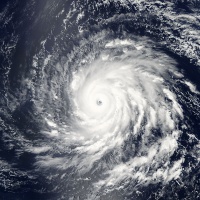
The sat loop imagery looks like she has undergone an eye wall replacement cycle over night and looks quite healthy this morning. Models have shifted the track south and west taking her through the Bahamas and near the Northern coast of Cuba in about4-6 days. Modeling conts to trend towards stronger ridging into the SW Atlantic which is ultimately what steers her in this direction; however, there is still much uncertainty esp beyond this time frame.
Check out this sat loop. http://col.st/Okdge This site is really cool. You can play with it and create your own sat loops using different overlays etc. R click to zoom in and out.


sroc4- Admin

- Posts : 8331
Join date : 2013-01-07
Re: Tracking Hurricane Irma
![]() by rb924119 Mon Sep 04, 2017 7:51 am
by rb924119 Mon Sep 04, 2017 7:51 am
rb924119- Meteorologist

- Posts : 6888
Reputation : 194
Join date : 2013-02-06
Age : 32
Location : Greentown, Pa
Re: Tracking Hurricane Irma
![]() by sroc4 Mon Sep 04, 2017 7:58 am
by sroc4 Mon Sep 04, 2017 7:58 am
SUMMARY OF 800 AM AST...1200 UTC...INFORMATION
----------------------------------------------
LOCATION...16.8N 52.6W
ABOUT 610 MI...980 KM E OF THE LEEWARD ISLANDS
MAXIMUM SUSTAINED WINDS...120 MPH...195 KM/H
PRESENT MOVEMENT...WSW OR 255 DEGREES AT 14 MPH...22 KM/H
MINIMUM CENTRAL PRESSURE...947 MB...27.96 INCHES
_________________
"In weather and in life, there's no winning and losing; there's only winning and learning."
WINTER 2012/2013 TOTALS 43.65"WINTER 2017/2018 TOTALS 62.85" WINTER 2022/2023 TOTALS 4.9"
WINTER 2013/2014 TOTALS 64.85"WINTER 2018/2019 TOTALS 14.25" WINTER 2023/2024 TOTALS 13.1"
WINTER 2014/2015 TOTALS 71.20"WINTER 2019/2020 TOTALS 6.35"
WINTER 2015/2016 TOTALS 35.00"WINTER 2020/2021 TOTALS 37.75"
WINTER 2016/2017 TOTALS 42.25"WINTER 2021/2022 TOTALS 31.65"

sroc4- Admin
- Posts : 8331
Reputation : 301
Join date : 2013-01-07
Location : Wading River, LI
Re: Tracking Hurricane Irma
![]() by rb924119 Mon Sep 04, 2017 8:02 am
by rb924119 Mon Sep 04, 2017 8:02 am
sroc4 wrote:8am update: As expected a bump up in he winds.
SUMMARY OF 800 AM AST...1200 UTC...INFORMATION
----------------------------------------------
LOCATION...16.8N 52.6W
ABOUT 610 MI...980 KM E OF THE LEEWARD ISLANDS
MAXIMUM SUSTAINED WINDS...120 MPH...195 KM/H
PRESENT MOVEMENT...WSW OR 255 DEGREES AT 14 MPH...22 KM/H
MINIMUM CENTRAL PRESSURE...947 MB...27.96 INCHES
That's an increase of 14mb in strength SINCE THE LAST UPDATE
rb924119- Meteorologist
- Posts : 6888
Reputation : 194
Join date : 2013-02-06
Age : 32
Location : Greentown, Pa
Re: Tracking Hurricane Irma
![]() by Radz Mon Sep 04, 2017 8:07 am
by Radz Mon Sep 04, 2017 8:07 am
sroc4 wrote:8am update: As expected a bump up in he winds.
SUMMARY OF 800 AM AST...1200 UTC...INFORMATION
----------------------------------------------
LOCATION...16.8N 52.6W
ABOUT 610 MI...980 KM E OF THE LEEWARD ISLANDS
MAXIMUM SUSTAINED WINDS...120 MPH...195 KM/H
PRESENT MOVEMENT...WSW OR 255 DEGREES AT 14 MPH...22 KM/H
MINIMUM CENTRAL PRESSURE...947 MB...27.96 INCHES
RI for sure, and looks amazing on satellite imagery currently

Radz- Pro Enthusiast

- Posts : 1028
Reputation : 17
Join date : 2013-01-12
Location : Cortlandt Manor NY
Re: Tracking Hurricane Irma
![]() by sroc4 Mon Sep 04, 2017 8:14 am
by sroc4 Mon Sep 04, 2017 8:14 am
_________________
"In weather and in life, there's no winning and losing; there's only winning and learning."
WINTER 2012/2013 TOTALS 43.65"WINTER 2017/2018 TOTALS 62.85" WINTER 2022/2023 TOTALS 4.9"
WINTER 2013/2014 TOTALS 64.85"WINTER 2018/2019 TOTALS 14.25" WINTER 2023/2024 TOTALS 13.1"
WINTER 2014/2015 TOTALS 71.20"WINTER 2019/2020 TOTALS 6.35"
WINTER 2015/2016 TOTALS 35.00"WINTER 2020/2021 TOTALS 37.75"
WINTER 2016/2017 TOTALS 42.25"WINTER 2021/2022 TOTALS 31.65"
sroc4- Admin
- Posts : 8331
Reputation : 301
Join date : 2013-01-07
Location : Wading River, LI
Re: Tracking Hurricane Irma
![]() by sroc4 Mon Sep 04, 2017 8:22 am
by sroc4 Mon Sep 04, 2017 8:22 am
_________________
"In weather and in life, there's no winning and losing; there's only winning and learning."
WINTER 2012/2013 TOTALS 43.65"WINTER 2017/2018 TOTALS 62.85" WINTER 2022/2023 TOTALS 4.9"
WINTER 2013/2014 TOTALS 64.85"WINTER 2018/2019 TOTALS 14.25" WINTER 2023/2024 TOTALS 13.1"
WINTER 2014/2015 TOTALS 71.20"WINTER 2019/2020 TOTALS 6.35"
WINTER 2015/2016 TOTALS 35.00"WINTER 2020/2021 TOTALS 37.75"
WINTER 2016/2017 TOTALS 42.25"WINTER 2021/2022 TOTALS 31.65"
sroc4- Admin
- Posts : 8331
Reputation : 301
Join date : 2013-01-07
Location : Wading River, LI
Re: Tracking Hurricane Irma
![]() by sroc4 Mon Sep 04, 2017 8:37 am
by sroc4 Mon Sep 04, 2017 8:37 am

Last edited by sroc4 on Mon Sep 04, 2017 8:56 am; edited 1 time in total
_________________
"In weather and in life, there's no winning and losing; there's only winning and learning."
WINTER 2012/2013 TOTALS 43.65"WINTER 2017/2018 TOTALS 62.85" WINTER 2022/2023 TOTALS 4.9"
WINTER 2013/2014 TOTALS 64.85"WINTER 2018/2019 TOTALS 14.25" WINTER 2023/2024 TOTALS 13.1"
WINTER 2014/2015 TOTALS 71.20"WINTER 2019/2020 TOTALS 6.35"
WINTER 2015/2016 TOTALS 35.00"WINTER 2020/2021 TOTALS 37.75"
WINTER 2016/2017 TOTALS 42.25"WINTER 2021/2022 TOTALS 31.65"
sroc4- Admin
- Posts : 8331
Reputation : 301
Join date : 2013-01-07
Location : Wading River, LI
Re: Tracking Hurricane Irma
![]() by Radz Mon Sep 04, 2017 8:38 am
by Radz Mon Sep 04, 2017 8:38 am
Radz- Pro Enthusiast
- Posts : 1028
Reputation : 17
Join date : 2013-01-12
Location : Cortlandt Manor NY
Re: Tracking Hurricane Irma
![]() by amugs Mon Sep 04, 2017 10:17 am
by amugs Mon Sep 04, 2017 10:17 am

Why cause look at what his favorite EPS models know suggests. Windshield wiper effect

Sroc our boy SANVU coming into play know - time will tell his downstream effetcs and how deep the trough gets, PNA spike, over teh top block etc - also Isotherm pointed out two possible tracks examining the upper air pattern - one a direct hit into Fla and then a turn N int op the SE and dyes off but can bring flooding rains up through our area, 2 - a turn N and hit OBX and cintinue N hugging the coast. He remains on this course as he has since he started tracking.
This is the track he likes in similarity - history loves to repeat itself and many experienced mets like Jim Witt always point this out!

_________________
Mugs
AKA:King: Snow Weenie
Self Proclaimed
WINTER 2014-15 : 55.12" +.02 for 6 coatings (avg. 35")
WINTER 2015-16 Total - 29.8" (Avg 35")
WINTER 2016-17 : 39.5" so far

amugs- Advanced Forecaster - Mod

- Posts : 15091
Reputation : 213
Join date : 2013-01-07
Age : 54
Location : Hillsdale,NJ
rb924119- Meteorologist
- Posts : 6888
Reputation : 194
Join date : 2013-02-06
Age : 32
Location : Greentown, Pa
Re: Tracking Hurricane Irma
![]() by amugs Mon Sep 04, 2017 10:21 am
by amugs Mon Sep 04, 2017 10:21 am

_________________
Mugs
AKA:King: Snow Weenie
Self Proclaimed
WINTER 2014-15 : 55.12" +.02 for 6 coatings (avg. 35")
WINTER 2015-16 Total - 29.8" (Avg 35")
WINTER 2016-17 : 39.5" so far
amugs- Advanced Forecaster - Mod
- Posts : 15091
Reputation : 213
Join date : 2013-01-07
Age : 54
Location : Hillsdale,NJ
Re: Tracking Hurricane Irma
![]() by jwalsh Mon Sep 04, 2017 11:10 am
by jwalsh Mon Sep 04, 2017 11:10 am
...HURRICANE WARNINGS ISSUED FOR PORTIONS OF THE LEEWARD ISLANDS...
...HURRICANE WATCHES ISSUED FOR THE BRITISH AND U.S. VIRGIN ISLANDS
AND PUERTO RICO...
SUMMARY OF 1100 AM AST...1500 UTC...INFORMATION
-----------------------------------------------
LOCATION...16.8N 53.3W
ABOUT 560 MI...905 KM E OF THE LEEWARD ISLANDS
MAXIMUM SUSTAINED WINDS...120 MPH...195 KM/H
PRESENT MOVEMENT...WSW OR 255 DEGREES AT 14 MPH...22 KM/H
MINIMUM CENTRAL PRESSURE...944 MB...27.88 INCHES
jwalsh- Posts : 60
Reputation : 0
Join date : 2016-01-18
Location : Commack, NY
Re: Tracking Hurricane Irma
![]() by rb924119 Mon Sep 04, 2017 11:23 am
by rb924119 Mon Sep 04, 2017 11:23 am
https://drive.google.com/open?id=0Byod2Sk27yNYMkpaRUFEUEdwblk
Keep in mind that the increase in SST anomalies along the bigger islands doesn't necessarily help my track idea (as a guiding low-level pressure boundary for the lower-level circulation to follow), but what it DOES do is mean that much more latent heat to feed into the ridge that I think will continue to trend stronger given the factors outlined in the video. However, as Irma would get into the Gulf, those cooler anomalies combined with the anomalous cool landmass juxtaposed with the warmer anomalies further east would likely allow Irma to remain very strong or maybe even intensify some **if the circulation remains north of the mountainous islands of Cuba/D.R.**, which I think makes the most sense given how these systems like to avoid contact with surface of higher friction (remember how Matthew(?) danced through the channel between those islands last year, I think it was). Why? Enhanced low-level convergence due to the temperature anomalies in the lower-levels.
Enjoy!!
rb924119- Meteorologist
- Posts : 6888
Reputation : 194
Join date : 2013-02-06
Age : 32
Location : Greentown, Pa
Re: Tracking Hurricane Irma
![]() by Frank_Wx Mon Sep 04, 2017 11:39 am
by Frank_Wx Mon Sep 04, 2017 11:39 am
jwalsh wrote:Advisory 21 - wind speed and movement the same, pressure down 3 mb
...HURRICANE WARNINGS ISSUED FOR PORTIONS OF THE LEEWARD ISLANDS...
...HURRICANE WATCHES ISSUED FOR THE BRITISH AND U.S. VIRGIN ISLANDS
AND PUERTO RICO...
SUMMARY OF 1100 AM AST...1500 UTC...INFORMATION
-----------------------------------------------
LOCATION...16.8N 53.3W
ABOUT 560 MI...905 KM E OF THE LEEWARD ISLANDS
MAXIMUM SUSTAINED WINDS...120 MPH...195 KM/H
PRESENT MOVEMENT...WSW OR 255 DEGREES AT 14 MPH...22 KM/H
MINIMUM CENTRAL PRESSURE...944 MB...27.88 INCHES
Irma is likely to keep intensifying. Very scary storm for whoever is in its path. I think we may begin seeing consensus with models beginning tomorrow. Ensembles starting to come around to a Florida to North Carolina type of landfall. Out to sea doesn't seem likely
_________________
_______________________________________________________________________________________________________
CLICK HERE to view NJ Strong Snowstorm Classifications

Frank_Wx- Godzilla Seeker
- Posts : 21305
Reputation : 328
Join date : 2013-01-05
Age : 31
Location : Jersey City, NJ -

Re: Tracking Hurricane Irma
![]() by Disneyprincess1592 Mon Sep 04, 2017 11:46 am
by Disneyprincess1592 Mon Sep 04, 2017 11:46 am
Disneyprincess1592- Posts : 34
Reputation : 0
Join date : 2017-08-31
Re: Tracking Hurricane Irma
![]() by nutleyblizzard Mon Sep 04, 2017 11:57 am
by nutleyblizzard Mon Sep 04, 2017 11:57 am

nutleyblizzard- Senior Enthusiast
- Posts : 1952
Reputation : 41
Join date : 2014-01-30
Age : 57
Location : Nutley, new jersey
Re: Tracking Hurricane Irma
![]() by nutleyblizzard Mon Sep 04, 2017 12:02 pm
by nutleyblizzard Mon Sep 04, 2017 12:02 pm
nutleyblizzard- Senior Enthusiast
- Posts : 1952
Reputation : 41
Join date : 2014-01-30
Age : 57
Location : Nutley, new jersey
Re: Tracking Hurricane Irma
![]() by jwalsh Mon Sep 04, 2017 12:05 pm
by jwalsh Mon Sep 04, 2017 12:05 pm
jwalsh- Posts : 60
Reputation : 0
Join date : 2016-01-18
Location : Commack, NY
Re: Tracking Hurricane Irma
![]() by jmanley32 Mon Sep 04, 2017 12:05 pm
by jmanley32 Mon Sep 04, 2017 12:05 pm

jmanley32- Senior Enthusiast
- Posts : 20512
Reputation : 108
Join date : 2013-12-12
Age : 42
Location : Yonkers, NY
Re: Tracking Hurricane Irma
![]() by jmanley32 Mon Sep 04, 2017 12:06 pm
by jmanley32 Mon Sep 04, 2017 12:06 pm
jmanley32- Senior Enthusiast
- Posts : 20512
Reputation : 108
Join date : 2013-12-12
Age : 42
Location : Yonkers, NY
Re: Tracking Hurricane Irma
![]() by Guest Mon Sep 04, 2017 12:07 pm
by Guest Mon Sep 04, 2017 12:07 pm
Yesterday's 12z for 9/9 0z

Today's 12z for 9/9 0z

Guest- Guest
Re: Tracking Hurricane Irma
![]() by jmanley32 Mon Sep 04, 2017 12:08 pm
by jmanley32 Mon Sep 04, 2017 12:08 pm
jmanley32- Senior Enthusiast
- Posts : 20512
Reputation : 108
Join date : 2013-12-12
Age : 42
Location : Yonkers, NY
Re: Tracking Hurricane Irma
![]() by jmanley32 Mon Sep 04, 2017 12:14 pm
by jmanley32 Mon Sep 04, 2017 12:14 pm
jmanley32- Senior Enthusiast
- Posts : 20512
Reputation : 108
Join date : 2013-12-12
Age : 42
Location : Yonkers, NY
jwalsh- Posts : 60
Reputation : 0
Join date : 2016-01-18
Location : Commack, NY
Page 20 of 35 • 1 ... 11 ... 19, 20, 21 ... 27 ... 35 ![]()
|
|
|