
 Search
Possible Snowstorm December 8th-9th
Page 14 of 15 •  1 ... 8 ... 13, 14, 15
 ![]()
Re: Possible Snowstorm December 8th-9th
![]() by amugs Thu Dec 07, 2017 10:17 pm
by amugs Thu Dec 07, 2017 10:17 pm
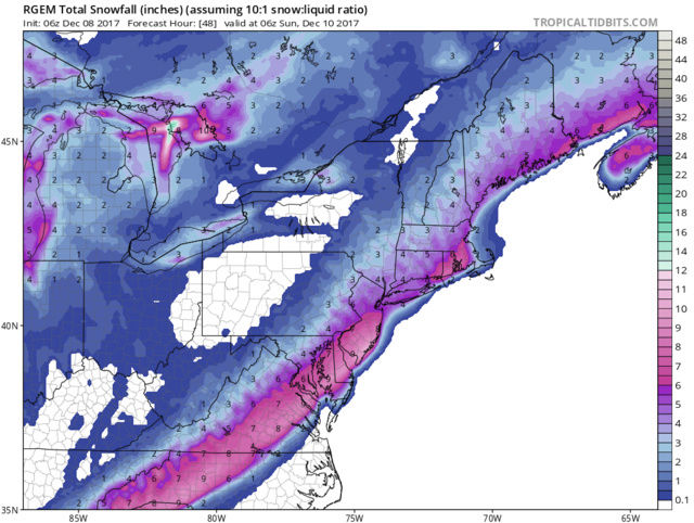
amugs- Advanced Forecaster - Mod

- Posts : 15091
Join date : 2013-01-07
Re: Possible Snowstorm December 8th-9th
![]() by Guest Thu Dec 07, 2017 10:20 pm
by Guest Thu Dec 07, 2017 10:20 pm
aiannone wrote:RGEM coming in with a big hit
Great job holding the fort tonight kid. Taking over in the big guys absence.
Guest- Guest
Re: Possible Snowstorm December 8th-9th
![]() by aiannone Thu Dec 07, 2017 10:21 pm
by aiannone Thu Dec 07, 2017 10:21 pm
syosnow94 wrote:aiannone wrote:RGEM coming in with a big hit
Great job holding the fort tonight kid. Taking over in the big guys absence.
LOL, i should be studying, but ehh this is more important and more interesting than accounting lol
_________________
-Alex Iannone-

aiannone- Senior Enthusiast - Mod
- Posts : 4813
Reputation : 92
Join date : 2013-01-07
Location : Saint James, LI (Northwest Suffolk Co.)
Re: Possible Snowstorm December 8th-9th
![]() by mikeypizano Thu Dec 07, 2017 10:23 pm
by mikeypizano Thu Dec 07, 2017 10:23 pm

mikeypizano- Pro Enthusiast

- Posts : 1118
Reputation : 66
Join date : 2017-01-05
Age : 35
Location : Wilkes-Barre/Scranton, PA
Re: Possible Snowstorm December 8th-9th
![]() by Guest Thu Dec 07, 2017 10:25 pm
by Guest Thu Dec 07, 2017 10:25 pm
Guest- Guest
Re: Possible Snowstorm December 8th-9th
![]() by nutleyblizzard Thu Dec 07, 2017 10:39 pm
by nutleyblizzard Thu Dec 07, 2017 10:39 pm

nutleyblizzard- Senior Enthusiast

- Posts : 1952
Reputation : 41
Join date : 2014-01-30
Age : 57
Location : Nutley, new jersey
Re: Possible Snowstorm December 8th-9th
![]() by Snow88 Thu Dec 07, 2017 10:41 pm
by Snow88 Thu Dec 07, 2017 10:41 pm

Snow88- Senior Enthusiast
- Posts : 2193
Reputation : 4
Join date : 2013-01-09
Age : 35
Location : Brooklyn, NY
Re: Possible Snowstorm December 8th-9th
![]() by jmanley32 Thu Dec 07, 2017 11:04 pm
by jmanley32 Thu Dec 07, 2017 11:04 pm

jmanley32- Senior Enthusiast
- Posts : 20512
Reputation : 108
Join date : 2013-12-12
Age : 42
Location : Yonkers, NY
Re: Possible Snowstorm December 8th-9th
![]() by SENJsnowman Thu Dec 07, 2017 11:30 pm
by SENJsnowman Thu Dec 07, 2017 11:30 pm
Good news out of Mt Holly in their 9 pm update!
.LONG TERM /FRIDAY NIGHT THROUGH THURSDAY/...
900 PM...Updated temperature, PoPs and weather grids for the
Friday night-Saturday event. Will hold off on making changes
the snowfall accumulations until the mid shift gets a complete
look at the 00Z guidance that comes in later tonight.
The biggest difference with the evening update was to increase
PoPs late Friday night and Saturday (most notably from the I-95
corridor/Delaware Valley, south/east) with increasing NWP
support for the occurrence of measurable precip across this part
of the forecast area.
The precipitation type should be snow for the bulk of the
event. The exception will be coastal locales near the
ocean/Delaware Bay where mixing will play a factor in limiting
snowfall accumulations (evident in probability of frozen
precipitation fields for the last several runs of NAM/NAM nest).
Yes, models have trended westward/wetter over the since last
night with 12Z/18Z model consensus painting one-half to one-inch
of QPF for areas just to the east of I-95. However, a steadfast
10:1 snow ratio should not be valid in the coastal plain given
a marginally warm surface and the potential for considerable
riming to take place (more likely between 5:1 and 8:1 in the
coastal plain for this event).
The one thing they say that I don't really buy is the 5:1 or 8:1 ratios.[/b]
SENJsnowman- Senior Enthusiast
- Posts : 1186
Reputation : 61
Join date : 2017-01-06
Age : 51
Location : Bayville, NJ
Re: Possible Snowstorm December 8th-9th
![]() by Snow88 Thu Dec 07, 2017 11:44 pm
by Snow88 Thu Dec 07, 2017 11:44 pm
Further west than the 12z run
Snow88- Senior Enthusiast
- Posts : 2193
Reputation : 4
Join date : 2013-01-09
Age : 35
Location : Brooklyn, NY
Re: Possible Snowstorm December 8th-9th
![]() by Snow88 Thu Dec 07, 2017 11:56 pm
by Snow88 Thu Dec 07, 2017 11:56 pm
The track is great for the NYC area
Snow88- Senior Enthusiast
- Posts : 2193
Reputation : 4
Join date : 2013-01-09
Age : 35
Location : Brooklyn, NY
Re: Possible Snowstorm December 8th-9th
![]() by Frank_Wx Thu Dec 07, 2017 11:58 pm
by Frank_Wx Thu Dec 07, 2017 11:58 pm

_________________
_______________________________________________________________________________________________________
CLICK HERE to view NJ Strong Snowstorm Classifications

Frank_Wx- Godzilla Seeker

- Posts : 21305
Reputation : 328
Join date : 2013-01-05
Age : 31
Location : Jersey City, NJ -

Re: Possible Snowstorm December 8th-9th
![]() by SoulSingMG Fri Dec 08, 2017 4:20 am
by SoulSingMG Fri Dec 08, 2017 4:20 am
National Weather Service New York NY
407 AM EST Fri Dec 8 2017
NJZ002-004-006-103>108-NYZ068>074-082100-
/O.CON.KOKX.WW.Y.0001.171209T1100Z-171210T0600Z/
Western Passaic-Eastern Passaic-Hudson-Western Bergen-
Eastern Bergen-Western Essex-Eastern Essex-Western Union-
Eastern Union-Putnam-Rockland-Northern Westchester-
Southern Westchester-New York (Manhattan)-Bronx-
Richmond (Staten Island)-
407 AM EST Fri Dec 8 2017
...WINTER WEATHER ADVISORY REMAINS IN EFFECT FROM 6 AM SATURDAY
TO 1 AM EST SUNDAY...
* WHAT...Snow expected. Plan on hazardous travel conditions.
Total snow accumulations of 2 to 4 inches are expected.
* WHERE...Portions of northeast New Jersey and southeast New
York.
* WHEN...From 6 AM Saturday to 1 AM EST Sunday. Highest snow
accumulation should occur Saturday morning into Saturday
evening.
* ADDITIONAL DETAILS...Be prepared for reduced visibilities at
times.

SoulSingMG- Senior Enthusiast
- Posts : 2853
Reputation : 74
Join date : 2013-12-11
Location : Long Island City, NY
Re: Possible Snowstorm December 8th-9th
![]() by rb924119 Fri Dec 08, 2017 5:12 am
by rb924119 Fri Dec 08, 2017 5:12 am
rb924119- Meteorologist

- Posts : 6889
Reputation : 194
Join date : 2013-02-06
Age : 32
Location : Greentown, Pa
Re: Possible Snowstorm December 8th-9th
![]() by Carter bk Fri Dec 08, 2017 6:10 am
by Carter bk Fri Dec 08, 2017 6:10 am
Carter bk- Posts : 73
Reputation : 5
Join date : 2017-12-07
Re: Possible Snowstorm December 8th-9th
![]() by rb924119 Fri Dec 08, 2017 6:11 am
by rb924119 Fri Dec 08, 2017 6:11 am
rb924119- Meteorologist
- Posts : 6889
Reputation : 194
Join date : 2013-02-06
Age : 32
Location : Greentown, Pa

skinsfan1177- Senior Enthusiast
- Posts : 4485
Reputation : 35
Join date : 2013-01-07
Age : 46
Location : Point Pleasant Boro
Re: Possible Snowstorm December 8th-9th
![]() by jmanley32 Fri Dec 08, 2017 6:39 am
by jmanley32 Fri Dec 08, 2017 6:39 am
you think the winter weather advisory could be upgraded? Seems ecven operational gfs was near 6+. What a nice surprise all this is! Even a wwa is better than we have seen in Dec in a while.rb924119 wrote:HOLY 06z GFS ENSEMBLES!! WARNING CRITERIA SNOW FOR ALL OF THE I-95!!!
jmanley32- Senior Enthusiast
- Posts : 20512
Reputation : 108
Join date : 2013-12-12
Age : 42
Location : Yonkers, NY
Re: Possible Snowstorm December 8th-9th
![]() by track17 Fri Dec 08, 2017 6:43 am
by track17 Fri Dec 08, 2017 6:43 am
track17- Posts : 454
Reputation : 4
Join date : 2016-01-09
Re: Possible Snowstorm December 8th-9th
![]() by jmanley32 Fri Dec 08, 2017 6:48 am
by jmanley32 Fri Dec 08, 2017 6:48 am
jmanley32- Senior Enthusiast
- Posts : 20512
Reputation : 108
Join date : 2013-12-12
Age : 42
Location : Yonkers, NY
Re: Possible Snowstorm December 8th-9th
![]() by amugs Fri Dec 08, 2017 6:48 am
by amugs Fri Dec 08, 2017 6:48 am


AND THE GEFS JU ST JUMPED 40 MILES WEST MOTHER OF LOVE!! Would be warning for level storm!!

_________________
Mugs
AKA:King: Snow Weenie
Self Proclaimed
WINTER 2014-15 : 55.12" +.02 for 6 coatings (avg. 35")
WINTER 2015-16 Total - 29.8" (Avg 35")
WINTER 2016-17 : 39.5" so far

amugs- Advanced Forecaster - Mod
- Posts : 15091
Reputation : 213
Join date : 2013-01-07
Age : 54
Location : Hillsdale,NJ
Re: Possible Snowstorm December 8th-9th
![]() by amugs Fri Dec 08, 2017 6:55 am
by amugs Fri Dec 08, 2017 6:55 am

_________________
Mugs
AKA:King: Snow Weenie
Self Proclaimed
WINTER 2014-15 : 55.12" +.02 for 6 coatings (avg. 35")
WINTER 2015-16 Total - 29.8" (Avg 35")
WINTER 2016-17 : 39.5" so far
amugs- Advanced Forecaster - Mod
- Posts : 15091
Reputation : 213
Join date : 2013-01-07
Age : 54
Location : Hillsdale,NJ
Re: Possible Snowstorm December 8th-9th
![]() by sroc4 Fri Dec 08, 2017 7:36 am
by sroc4 Fri Dec 08, 2017 7:36 am
Confidence has continued to increase regarding our first
accumulating snowfall event across the Tri-State Saturday into
Saturday evening. Dprog/Dt trends in the models over the last 24
hours or so are quite impressive with increased amplification of the
upper jet over the northeast/New England as well as with the overall
amplification of the middle and upper level trough across the
eastern States. These trends are going to lead to an organizing low
pressure system over the southeast States tonight that will
gradually strengthen as it moves up the coast on Saturday south and
east of Long Island. Initially the low develops from southern
stream energy across the southeast, but another piece of energy
in the northern stream will help amplify the middle/upper trough
and thus intensity the low as it passes near or just to the
east of the 40N/70W benchmark. The low quickly lifts off the New
England coast Saturday night as the upper trough slides
overhead.
Models have come into much better agreement with the expanse of the
precipitation shield as well as the overall timing.
Increasing lift begins late tonight as the upper jet amplifies to
speeds close to 200 kt across New England. The region will lie near
the right entrance region of this upper jet core bringing large
scale lift and eventually precipitation. The lower levels initially
are going to be dry, so evaporative cooling will have to take place
to get precip to the surface. Temperature profiles are
supportive of all snow at the onset early Saturday morning.
There remains some uncertainty on how quickly the lower levels
saturate, but should see light snow overspread the region from
south to north around or just after sunrise Saturday.
Accumulating snow is expected to continue for much of the day as the
upper jet provides excellent lift in combination with some weak
thermal forcing as the low passes to the south and east of Long
Island in the afternoon and evening. The main concern regarding
temperatures is with the surface layer. While there is no arctic
high pressure to the north, the air is sufficiently dry at the
start to allow the lower levels to cool. As some warmer aloft
advects northward, temperatures aloft will warm slightly but
should stay below 0C. The only concern for any warm nose at this
type would be across the east end of Long Island, where some
models indicate the 0C line at 850 inching close for a few hours
in the afternoon/evening. Some locations may see temperatures
rise just above freezing in the afternoon, but this should not
impact PTYPE except for the Forks of Long Island where
temperatures could reach the middle 30s. Some rain could mix in
there. The snow gradually tapers off from west to east this
evening. Forecast soundings show some drying aloft which may
switch snow growth to less dendrites and more needles, limiting
snow accumulation.
A winter weather advisory has been issued for all zones except
Orange County. Total snowfall accumulations range from 1 to 3 inches
across Orange County, 2 to 4 inches for the rest of the Lower Hudson
Valley, NE NJ, and Manhattan, Bronx, and Staten Island. For
Queens, Brooklyn, Long Island, and southern Connecticut, totals
range from from 4 to 6 inches.
While confidence is high on the above scenario, slight shifts in the
track of the storm could lower or increase snowfall
accumulations. A shift west with the low track could introduce
some mixing with rain across eastern Long Island and southeast
Connecticut. The latest experimental High End Amount shows a 1
in 10 chance for warning level snowfall from the Hudson River
corridor on east. Snow to liquid ratios may range from 8:1 to
10:1 with this event and could be a bit lower across the
southeast coast of Long Island.
_________________
"In weather and in life, there's no winning and losing; there's only winning and learning."
WINTER 2012/2013 TOTALS 43.65"WINTER 2017/2018 TOTALS 62.85" WINTER 2022/2023 TOTALS 4.9"
WINTER 2013/2014 TOTALS 64.85"WINTER 2018/2019 TOTALS 14.25" WINTER 2023/2024 TOTALS 13.1"
WINTER 2014/2015 TOTALS 71.20"WINTER 2019/2020 TOTALS 6.35"
WINTER 2015/2016 TOTALS 35.00"WINTER 2020/2021 TOTALS 37.75"
WINTER 2016/2017 TOTALS 42.25"WINTER 2021/2022 TOTALS 31.65"

sroc4- Admin
- Posts : 8331
Reputation : 301
Join date : 2013-01-07
Location : Wading River, LI
Re: Possible Snowstorm December 8th-9th
![]() by jmanley32 Fri Dec 08, 2017 7:37 am
by jmanley32 Fri Dec 08, 2017 7:37 am
is that nearly 6-12 for most? and the mean that means some ensembles were actually higher? but how many compared to how many lower. still this is all getting me fired up for winter for sure.amugs wrote:The mean wowza
jmanley32- Senior Enthusiast
- Posts : 20512
Reputation : 108
Join date : 2013-12-12
Age : 42
Location : Yonkers, NY
Re: Possible Snowstorm December 8th-9th
![]() by skinsfan1177 Fri Dec 08, 2017 7:38 am
by skinsfan1177 Fri Dec 08, 2017 7:38 am
skinsfan1177- Senior Enthusiast
- Posts : 4485
Reputation : 35
Join date : 2013-01-07
Age : 46
Location : Point Pleasant Boro
Re: Possible Snowstorm December 8th-9th
![]() by mikeypizano Fri Dec 08, 2017 8:13 am
by mikeypizano Fri Dec 08, 2017 8:13 am
mikeypizano- Pro Enthusiast
- Posts : 1118
Reputation : 66
Join date : 2017-01-05
Age : 35
Location : Wilkes-Barre/Scranton, PA
Re: Possible Snowstorm December 8th-9th
![]() by Snow88 Fri Dec 08, 2017 8:33 am
by Snow88 Fri Dec 08, 2017 8:33 am
Snow88- Senior Enthusiast
- Posts : 2193
Reputation : 4
Join date : 2013-01-09
Age : 35
Location : Brooklyn, NY
Page 14 of 15 • 1 ... 8 ... 13, 14, 15 ![]()
|
|
|