
 Search
FEB 17th-18th Snow? Sleet? Rain?
Page 4 of 15 •  1, 2, 3, 4, 5 ... 9 ... 15
 ![]()
Re: FEB 17th-18th Snow? Sleet? Rain?
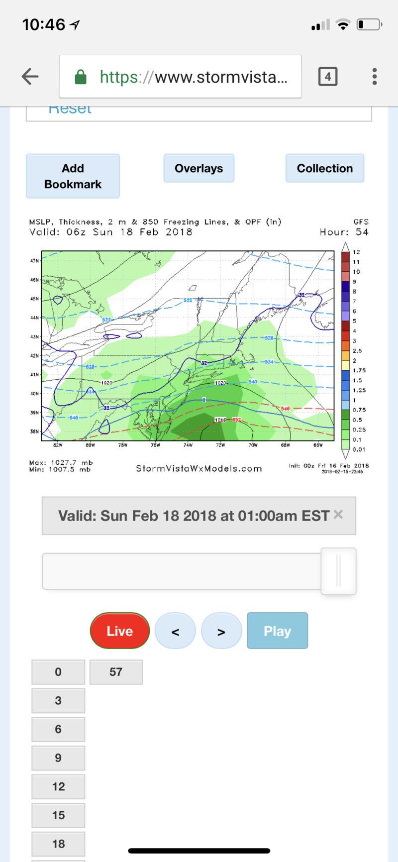
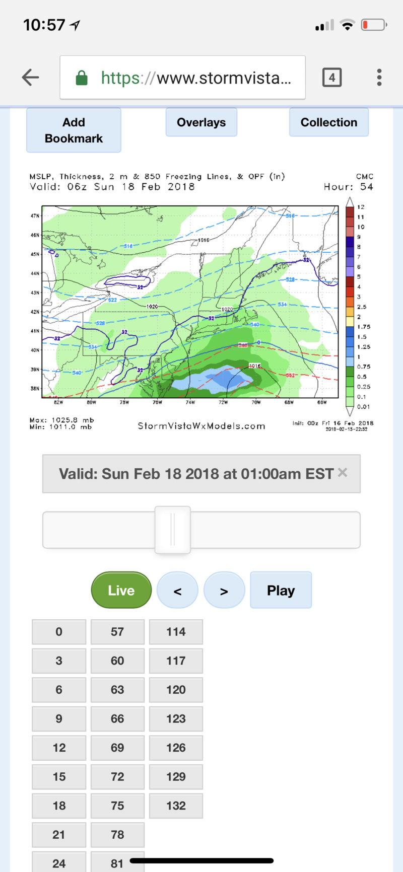
![]() by track17 Thu Feb 15, 2018 10:09 pm
by track17 Thu Feb 15, 2018 10:09 pm
track17- Posts : 454
Join date : 2016-01-09
Re: FEB 17th-18th Snow? Sleet? Rain?
![]() by aiannone Thu Feb 15, 2018 10:10 pm
by aiannone Thu Feb 15, 2018 10:10 pm
track17 wrote:Thanks Frank it just honestly gets confusing because people have different definitions
Sorry about that. Good explanation from frank though.
aiannone- Senior Enthusiast - Mod

- Posts : 4813
Join date : 2013-01-07
Re: FEB 17th-18th Snow? Sleet? Rain?
![]() by track17 Thu Feb 15, 2018 10:10 pm
by track17 Thu Feb 15, 2018 10:10 pm
track17- Posts : 454
Reputation : 4
Join date : 2016-01-09
track17- Posts : 454
Reputation : 4
Join date : 2016-01-09
Re: FEB 17th-18th Snow? Sleet? Rain?
![]() by aiannone Thu Feb 15, 2018 10:11 pm
by aiannone Thu Feb 15, 2018 10:11 pm
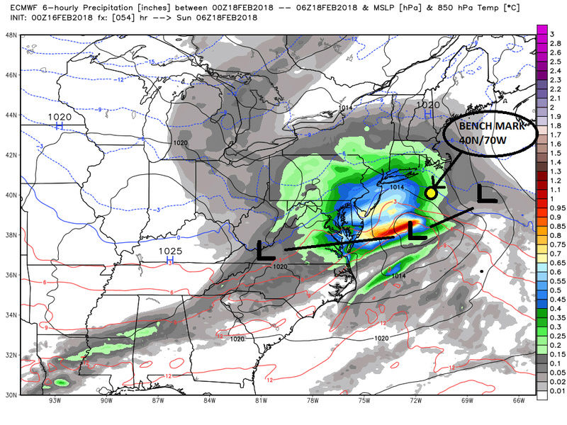
track17 wrote:Aionnone that do you have a version of that map that shows nj. Just wondering because my nj gets cut off
Sorry that I got from someone else. I don’t have access to wxbell anymore.
_________________
-Alex Iannone-

aiannone- Senior Enthusiast - Mod
- Posts : 4813
Reputation : 92
Join date : 2013-01-07
Location : Saint James, LI (Northwest Suffolk Co.)
Re: FEB 17th-18th Snow? Sleet? Rain?
![]() by track17 Thu Feb 15, 2018 10:15 pm
by track17 Thu Feb 15, 2018 10:15 pm
track17- Posts : 454
Reputation : 4
Join date : 2016-01-09
Re: FEB 17th-18th Snow? Sleet? Rain?
![]() by aiannone Thu Feb 15, 2018 10:47 pm
by aiannone Thu Feb 15, 2018 10:47 pm
_________________
-Alex Iannone-
aiannone- Senior Enthusiast - Mod
- Posts : 4813
Reputation : 92
Join date : 2013-01-07
Location : Saint James, LI (Northwest Suffolk Co.)
Re: FEB 17th-18th Snow? Sleet? Rain?
![]() by aiannone Thu Feb 15, 2018 10:58 pm
by aiannone Thu Feb 15, 2018 10:58 pm
_________________
-Alex Iannone-
aiannone- Senior Enthusiast - Mod
- Posts : 4813
Reputation : 92
Join date : 2013-01-07
Location : Saint James, LI (Northwest Suffolk Co.)
Re: FEB 17th-18th Snow? Sleet? Rain?
![]() by Math23x7 Thu Feb 15, 2018 11:27 pm
by Math23x7 Thu Feb 15, 2018 11:27 pm
Math23x7- Wx Statistician Guru

- Posts : 2379
Reputation : 68
Join date : 2013-01-08
Re: FEB 17th-18th Snow? Sleet? Rain?
![]() by aiannone Thu Feb 15, 2018 11:29 pm
by aiannone Thu Feb 15, 2018 11:29 pm
Math23x7 wrote:The fact that the high is to our east and the fact that there has been a tendency for a NW trend 1-2 days out is why I'm still not sold on this system. IMO, areas north and west cash in on the snow while for NYC south and east, it's a mainly rain event.
While you might be right. The placement of the high is not the end all. Many other factors need to be considered when forecasting the precip type.
_________________
-Alex Iannone-
aiannone- Senior Enthusiast - Mod
- Posts : 4813
Reputation : 92
Join date : 2013-01-07
Location : Saint James, LI (Northwest Suffolk Co.)
Re: FEB 17th-18th Snow? Sleet? Rain?
![]() by frank 638 Fri Feb 16, 2018 4:15 am
by frank 638 Fri Feb 16, 2018 4:15 am
frank 638- Senior Enthusiast

- Posts : 2823
Reputation : 37
Join date : 2016-01-01
Age : 40
Location : bronx ny
Re: FEB 17th-18th Snow? Sleet? Rain?
![]() by sroc4 Fri Feb 16, 2018 7:13 am
by sroc4 Fri Feb 16, 2018 7:13 am
Last edited by sroc4 on Fri Feb 16, 2018 8:43 am; edited 1 time in total
_________________
"In weather and in life, there's no winning and losing; there's only winning and learning."
WINTER 2012/2013 TOTALS 43.65"WINTER 2017/2018 TOTALS 62.85" WINTER 2022/2023 TOTALS 4.9"
WINTER 2013/2014 TOTALS 64.85"WINTER 2018/2019 TOTALS 14.25" WINTER 2023/2024 TOTALS 13.1"
WINTER 2014/2015 TOTALS 71.20"WINTER 2019/2020 TOTALS 6.35"
WINTER 2015/2016 TOTALS 35.00"WINTER 2020/2021 TOTALS 37.75"
WINTER 2016/2017 TOTALS 42.25"WINTER 2021/2022 TOTALS 31.65"

sroc4- Admin

- Posts : 8331
Reputation : 301
Join date : 2013-01-07
Location : Wading River, LI
Re: FEB 17th-18th Snow? Sleet? Rain?
![]() by billg315 Fri Feb 16, 2018 7:16 am
by billg315 Fri Feb 16, 2018 7:16 am

billg315- Advanced Forecaster - Mod
- Posts : 4461
Reputation : 185
Join date : 2015-01-24
Age : 50
Location : Flemington, NJ
Re: FEB 17th-18th Snow? Sleet? Rain?
![]() by amugs Fri Feb 16, 2018 7:39 am
by amugs Fri Feb 16, 2018 7:39 am
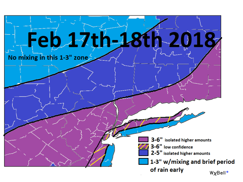
billg315 wrote:Mt Holly NWS has issued Winter Storm Watch for Southeast PA and the NW parts of Central and North Jersey for Saturday night for 4-6” of snow. Further south and east mainly rain. Looks to me like the best place to be is the most dangerous place to be for a snow lover: near where the final R/S line sets up, just on the snow side. I think if you go too far N and W of that the precip will be lighter and more short-lived somewhat reducing totals. If you go just S and E if it you’ll be mainly rain. But if you can get close to the rain without getting into the rain the snow could be heavy for a time. A heavy wet snow at that.
Your typical nina esque storm we lived through the 70's adn 80's.

_________________
Mugs
AKA:King: Snow Weenie
Self Proclaimed
WINTER 2014-15 : 55.12" +.02 for 6 coatings (avg. 35")
WINTER 2015-16 Total - 29.8" (Avg 35")
WINTER 2016-17 : 39.5" so far

amugs- Advanced Forecaster - Mod
- Posts : 15091
Reputation : 213
Join date : 2013-01-07
Age : 54
Location : Hillsdale,NJ
Re: FEB 17th-18th Snow? Sleet? Rain?
![]() by CPcantmeasuresnow Fri Feb 16, 2018 7:47 am
by CPcantmeasuresnow Fri Feb 16, 2018 7:47 am
Saturday
Increasing clouds, with a high near 37. Wind chill values between 15 and 25. Light and variable wind becoming south 5 to 7 mph in the afternoon.
Saturday Night
Snow, mainly before 3am. Low around 27. South wind around 6 mph becoming calm after midnight. Chance of precipitation is 90%. New snow accumulation of 3 to 7 inches possible.
Sunday
Mostly cloudy, then gradually becoming sunny, with a high near 44. West wind 6 to 8 mph.
Sunday Night
Mostly clear, with a low around 27.

CPcantmeasuresnow- Wx Statistician Guru
- Posts : 7274
Reputation : 230
Join date : 2013-01-07
Age : 103
Location : Eastern Orange County, NY
Re: FEB 17th-18th Snow? Sleet? Rain?
![]() by jmanley32 Fri Feb 16, 2018 7:55 am
by jmanley32 Fri Feb 16, 2018 7:55 am

jmanley32- Senior Enthusiast
- Posts : 20512
Reputation : 108
Join date : 2013-12-12
Age : 42
Location : Yonkers, NY
Re: FEB 17th-18th Snow? Sleet? Rain?
![]() by amugs Fri Feb 16, 2018 8:40 am
by amugs Fri Feb 16, 2018 8:40 am

_________________
Mugs
AKA:King: Snow Weenie
Self Proclaimed
WINTER 2014-15 : 55.12" +.02 for 6 coatings (avg. 35")
WINTER 2015-16 Total - 29.8" (Avg 35")
WINTER 2016-17 : 39.5" so far
amugs- Advanced Forecaster - Mod
- Posts : 15091
Reputation : 213
Join date : 2013-01-07
Age : 54
Location : Hillsdale,NJ
Re: FEB 17th-18th Snow? Sleet? Rain?
![]() by sroc4 Fri Feb 16, 2018 8:40 am
by sroc4 Fri Feb 16, 2018 8:40 am
_________________
"In weather and in life, there's no winning and losing; there's only winning and learning."
WINTER 2012/2013 TOTALS 43.65"WINTER 2017/2018 TOTALS 62.85" WINTER 2022/2023 TOTALS 4.9"
WINTER 2013/2014 TOTALS 64.85"WINTER 2018/2019 TOTALS 14.25" WINTER 2023/2024 TOTALS 13.1"
WINTER 2014/2015 TOTALS 71.20"WINTER 2019/2020 TOTALS 6.35"
WINTER 2015/2016 TOTALS 35.00"WINTER 2020/2021 TOTALS 37.75"
WINTER 2016/2017 TOTALS 42.25"WINTER 2021/2022 TOTALS 31.65"
sroc4- Admin
- Posts : 8331
Reputation : 301
Join date : 2013-01-07
Location : Wading River, LI
Re: FEB 17th-18th Snow? Sleet? Rain?
![]() by SoulSingMG Fri Feb 16, 2018 9:15 am
by SoulSingMG Fri Feb 16, 2018 9:15 am
With that said, I'll pray all day for our Winter Storm Warning upgrade and a miracle! Winter ain't over, even after this threat and next week's sultry weather. ;-)

SoulSingMG- Senior Enthusiast
- Posts : 2853
Reputation : 74
Join date : 2013-12-11
Location : Long Island City, NY
Re: FEB 17th-18th Snow? Sleet? Rain?
![]() by aiannone Fri Feb 16, 2018 9:23 am
by aiannone Fri Feb 16, 2018 9:23 am
_________________
-Alex Iannone-
aiannone- Senior Enthusiast - Mod
- Posts : 4813
Reputation : 92
Join date : 2013-01-07
Location : Saint James, LI (Northwest Suffolk Co.)
Re: FEB 17th-18th Snow? Sleet? Rain?
![]() by Dtone Fri Feb 16, 2018 9:25 am
by Dtone Fri Feb 16, 2018 9:25 am
SoulSingMG wrote:Sigh. This has bust written all over it. I can hear it now: "It was just too warm the day before. The ground temp. The storm's progressive nature. Temps." Cranky WX and Lee Goldberg aren't buying it, calling for 1-3 NYC metro.
With that said, I'll pray all day for our Winter Storm Warning upgrade and a miracle! Winter ain't over, even after this threat and next week's sultry weather. ;-)
The fact that its at night gives me some hope. 33 - 34 * at night can acclumate as long as it comes down heavy for a while.
If a chilly Sat will be enough to cool down the ground in urban areas is a concern too
Sent from Topic'it App
Dtone- Wx Statistician Guru
- Posts : 1738
Reputation : 9
Join date : 2013-08-26
Location : Bronx, NY
Re: FEB 17th-18th Snow? Sleet? Rain?
![]() by aiannone Fri Feb 16, 2018 9:28 am
by aiannone Fri Feb 16, 2018 9:28 am
_________________
-Alex Iannone-
aiannone- Senior Enthusiast - Mod
- Posts : 4813
Reputation : 92
Join date : 2013-01-07
Location : Saint James, LI (Northwest Suffolk Co.)
Re: FEB 17th-18th Snow? Sleet? Rain?
![]() by hyde345 Fri Feb 16, 2018 9:33 am
by hyde345 Fri Feb 16, 2018 9:33 am
SoulSingMG wrote:Sigh. This has bust written all over it. I can hear it now: "It was just too warm the day before. The ground temp. The storm's progressive nature. Temps." Cranky WX and Lee Goldberg aren't buying it, calling for 1-3 NYC metro.
With that said, I'll pray all day for our Winter Storm Warning upgrade and a miracle! Winter ain't over, even after this threat and next week's sultry weather. ;-)
You will do ok in Westchester. It's people around and north of 84 that have to worry. I don't see more than 1-3 for me.

hyde345- Pro Enthusiast

- Posts : 1082
Reputation : 48
Join date : 2013-01-08
Location : Hyde Park, NY
SoulSingMG- Senior Enthusiast
- Posts : 2853
Reputation : 74
Join date : 2013-12-11
Location : Long Island City, NY
Re: FEB 17th-18th Snow? Sleet? Rain?
![]() by aiannone Fri Feb 16, 2018 9:51 am
by aiannone Fri Feb 16, 2018 9:51 am
_________________
-Alex Iannone-
aiannone- Senior Enthusiast - Mod
- Posts : 4813
Reputation : 92
Join date : 2013-01-07
Location : Saint James, LI (Northwest Suffolk Co.)
Re: FEB 17th-18th Snow? Sleet? Rain?
![]() by SoulSingMG Fri Feb 16, 2018 10:24 am
by SoulSingMG Fri Feb 16, 2018 10:24 am
NWS @ 12z:

SoulSingMG- Senior Enthusiast
- Posts : 2853
Reputation : 74
Join date : 2013-12-11
Location : Long Island City, NY
Re: FEB 17th-18th Snow? Sleet? Rain?
![]() by aiannone Fri Feb 16, 2018 11:32 am
by aiannone Fri Feb 16, 2018 11:32 am
At the afternoon or morning update package the NWS will convert watches to Advisories for 2-4" with isolated amounts of 5" in the heavier bands
_________________
-Alex Iannone-
aiannone- Senior Enthusiast - Mod
- Posts : 4813
Reputation : 92
Join date : 2013-01-07
Location : Saint James, LI (Northwest Suffolk Co.)
Page 4 of 15 • 1, 2, 3, 4, 5 ... 9 ... 15 ![]()
|
|
|