March 7th-8th 2018 Storm Potential
+40
mmanisca
crippo84
Scullybutcher
deadrabbit79
SnowForest
Carter bk
mikeypizano
essexcountypete
DAYBLAZER
jimv45
Dunnzoo
docstox12
SENJsnowman
Grselig
Radz
frank 638
skinsfan1177
RJB8525
algae888
Math23x7
Sanchize06
CPcantmeasuresnow
Frank_Wx
adamfitz1969
rb924119
billg315
Snow88
WeatherBob
Vinnydula
hurrysundown23
Quietace
track17
aiannone
nutleyblizzard
SoulSingMG
jmanley32
weatherwatchermom
snowday111
amugs
sroc4
44 posters
Page 3 of 19
Page 3 of 19 •  1, 2, 3, 4 ... 11 ... 19
 Re: March 7th-8th 2018 Storm Potential
It looks like winds could be a issue yet again but nowhere near the magnitude of Friday, depends on how much this is able to bomb out before pulling away.
jmanley32- Senior Enthusiast

- Posts : 20512
Join date : 2013-12-12
 Re: March 7th-8th 2018 Storm Potential
Seems to be alot of hype on fb about this storm. So soon
Vinnydula- Pro Enthusiast

- Posts : 778
Join date : 2013-12-12
 Re: March 7th-8th 2018 Storm Potential
We all might be nerds and geeks but that guy on the video is a Dweeb. He iIs the most confusing and incoherent meteorologist I have ever heard. If you look at some of these precip totals he is talking about it seems the end date is March 12th. You don’t even know what storm he is talking about.
Well in the dictionary a nerd is a dweeb, but you get my point with this guy! HAHA
Well in the dictionary a nerd is a dweeb, but you get my point with this guy! HAHA

WeatherBob- Meteorologist

- Posts : 683
Reputation : 83
Join date : 2013-12-13
Location : Caldwell, NJ - NW Essex County - Altitude 500 FT
 Re: March 7th-8th 2018 Storm Potential
I am about 99.9% sure he doesn't have a met degree....Some people us like to call themselves meteorologists.WeatherBob wrote:We all might be nerds and geeks but that guy on the video is a Dweeb. He iIs the most confusing and incoherent meteorologist I have ever heard. If you look at some of these precip totals he is talking about it seems the end date is March 12th. You don’t even know what storm he is talking about.
Well in the dictionary a nerd is a dweeb, but you get my point with this guy! HAHA

Quietace- Meteorologist - Mod

- Posts : 3687
Reputation : 33
Join date : 2013-01-07
Age : 27
Location : Point Pleasant, NJ
 Re: March 7th-8th 2018 Storm Potential
Quiet- your probably right! Maybe he can help Syos with his snow maps, HAHA! Well onto the storm at hand for us!

WeatherBob- Meteorologist

- Posts : 683
Reputation : 83
Join date : 2013-12-13
Location : Caldwell, NJ - NW Essex County - Altitude 500 FT
 Re: March 7th-8th 2018 Storm Potential
https://www.pscp.tv/w/1BRKjrMAbqRKw Bernie Rayno's latest

weatherwatchermom- Senior Enthusiast

- Posts : 3729
Reputation : 77
Join date : 2014-11-25
Age : 60
Location : Hazlet Township, NJ
 Re: March 7th-8th 2018 Storm Potential
GEFS show 3-6 for NYC and a lot more for interior areas
Members are really tight together but some are leaning left and getting very close to Long Island. It's an outlier now but I hope they trend east.
Members are really tight together but some are leaning left and getting very close to Long Island. It's an outlier now but I hope they trend east.

Snow88- Senior Enthusiast

- Posts : 2193
Reputation : 4
Join date : 2013-01-09
Age : 35
Location : Brooklyn, NY
 Re: March 7th-8th 2018 Storm Potential
Could be interesting timing on this. If the start delays a few hours many schools and businesses may open Wednesday. And while a lot of the heavy precip will be after 4 pm (so that will help snow accumulation chances at the back end) it looks like it could pick up in intensity earlier in the day. If it sticks the Wednesday evening commute could be an absolute nightmare.

billg315- Advanced Forecaster - Mod

- Posts : 4461
Reputation : 185
Join date : 2015-01-24
Age : 50
Location : Flemington, NJ
 Re: March 7th-8th 2018 Storm Potential
Only 3 pages??
Chrips this storm has warning level criteria written all over and Godzilla potential to boot.
That guy in the video needs stop his pseudo portrayal of a met - so false and wrong.
The block is going to slow this up and give it a push west - 50/50, conflunce over head and the 700MB LP looks to be in a very good spot about 25 miles NW of the NYC metro region.
NAVY is fricking bomb - perfect look by this model at this range

NAVY ENS

RGEM just smokes us - need this to hold or improve LOL

SREFS HOLY WETNESS!!!!!!
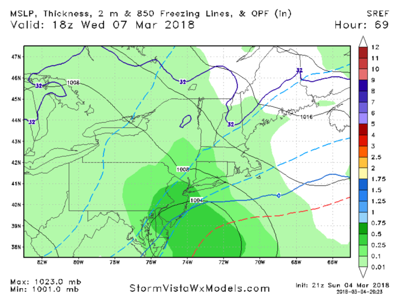

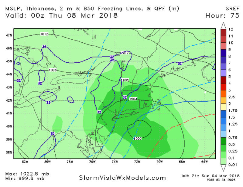
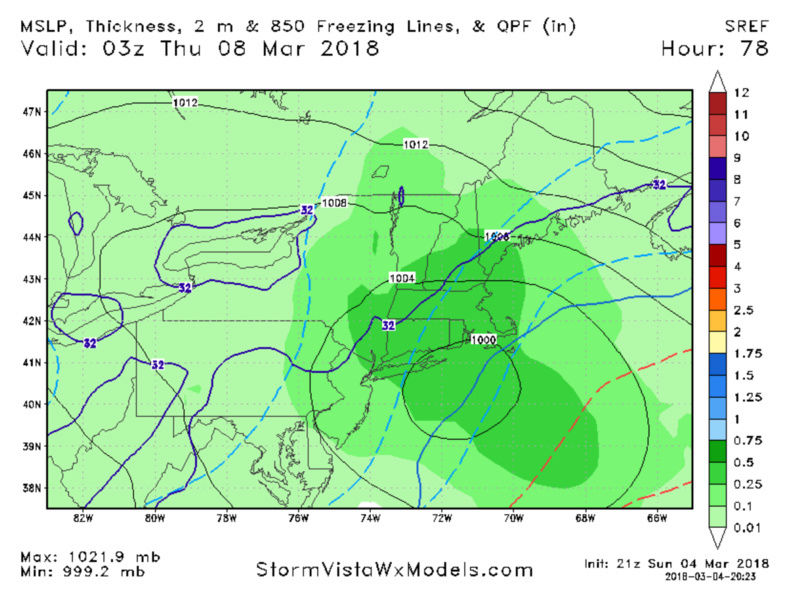
Chrips this storm has warning level criteria written all over and Godzilla potential to boot.
That guy in the video needs stop his pseudo portrayal of a met - so false and wrong.
The block is going to slow this up and give it a push west - 50/50, conflunce over head and the 700MB LP looks to be in a very good spot about 25 miles NW of the NYC metro region.
NAVY is fricking bomb - perfect look by this model at this range

NAVY ENS

RGEM just smokes us - need this to hold or improve LOL
SREFS HOLY WETNESS!!!!!!


_________________
Mugs
AKA:King: Snow Weenie
Self Proclaimed
WINTER 2014-15 : 55.12" +.02 for 6 coatings (avg. 35")
WINTER 2015-16 Total - 29.8" (Avg 35")
WINTER 2016-17 : 39.5" so far

amugs- Advanced Forecaster - Mod

- Posts : 15091
Reputation : 213
Join date : 2013-01-07
Age : 54
Location : Hillsdale,NJ
 Re: March 7th-8th 2018 Storm Potential
From DxSnow
Look how even on the GFS which is more tucked in than all guidance, how the COMPACT circulation means the northerly winds pull right into the center of the storm. This is why I’m not that worried about temperatures on the coast, should this storm produce to its potential...even with a close to the coast track. The compact scenario also narrows the radius of the “usual” banding rules with your position relative to the H5, H7, and surface circulations.

These northerly winds all pulling right into the circulation also lead to more frontogenesis.
NAM
Additionally, the NAM is actually less tucked in than the GFS, though it’s still pretty close to the coast, particularly with the dual LP center that forms to the west. And again, look how much northerly flow gets pulled right into the storm at 21z Wednesday. Perfect for cold, and perfect for a CCB.

Look how even on the GFS which is more tucked in than all guidance, how the COMPACT circulation means the northerly winds pull right into the center of the storm. This is why I’m not that worried about temperatures on the coast, should this storm produce to its potential...even with a close to the coast track. The compact scenario also narrows the radius of the “usual” banding rules with your position relative to the H5, H7, and surface circulations.

These northerly winds all pulling right into the circulation also lead to more frontogenesis.
NAM
Additionally, the NAM is actually less tucked in than the GFS, though it’s still pretty close to the coast, particularly with the dual LP center that forms to the west. And again, look how much northerly flow gets pulled right into the storm at 21z Wednesday. Perfect for cold, and perfect for a CCB.

_________________
Mugs
AKA:King: Snow Weenie
Self Proclaimed
WINTER 2014-15 : 55.12" +.02 for 6 coatings (avg. 35")
WINTER 2015-16 Total - 29.8" (Avg 35")
WINTER 2016-17 : 39.5" so far

amugs- Advanced Forecaster - Mod

- Posts : 15091
Reputation : 213
Join date : 2013-01-07
Age : 54
Location : Hillsdale,NJ
 Re: March 7th-8th 2018 Storm Potential
SREFS Plumes
Lga 6.54"
TTN 6.59
ISP 3.43”
EWR 6.77”
Lga 6.54"
TTN 6.59
ISP 3.43”
EWR 6.77”
_________________
Mugs
AKA:King: Snow Weenie
Self Proclaimed
WINTER 2014-15 : 55.12" +.02 for 6 coatings (avg. 35")
WINTER 2015-16 Total - 29.8" (Avg 35")
WINTER 2016-17 : 39.5" so far

amugs- Advanced Forecaster - Mod

- Posts : 15091
Reputation : 213
Join date : 2013-01-07
Age : 54
Location : Hillsdale,NJ
 Re: March 7th-8th 2018 Storm Potential
I’d assume with a Wednesday morning start time that watches would have to go up tmw afternoon if the threat of warning criteria snow still exisits
_________________
-Alex Iannone-

aiannone- Senior Enthusiast - Mod

- Posts : 4813
Reputation : 92
Join date : 2013-01-07
Location : Saint James, LI (Northwest Suffolk Co.)
 Re: March 7th-8th 2018 Storm Potential
Can tell you right now NAM coming in like the GFS here. Heights higher than 18z along EC which means more amplified solution, IMO. Let's see.
rb924119- Meteorologist

- Posts : 6888
Reputation : 194
Join date : 2013-02-06
Age : 32
Location : Greentown, Pa
 Re: March 7th-8th 2018 Storm Potential
rb924119 wrote:Can tell you right now NAM coming in like the GFS here. Heights higher than 18z along EC which means more amplified solution, IMO. Let's see.
How can it get any better than 18z lol?!!!
_________________
-Alex Iannone-

aiannone- Senior Enthusiast - Mod

- Posts : 4813
Reputation : 92
Join date : 2013-01-07
Location : Saint James, LI (Northwest Suffolk Co.)
 Re: March 7th-8th 2018 Storm Potential
aiannone wrote:rb924119 wrote:Can tell you right now NAM coming in like the GFS here. Heights higher than 18z along EC which means more amplified solution, IMO. Let's see.
How can it get any better than 18z lol?!!!
Careful here, more amplified means closer to the coast......
rb924119- Meteorologist

- Posts : 6888
Reputation : 194
Join date : 2013-02-06
Age : 32
Location : Greentown, Pa
 Re: March 7th-8th 2018 Storm Potential
rb924119 wrote:aiannone wrote:rb924119 wrote:Can tell you right now NAM coming in like the GFS here. Heights higher than 18z along EC which means more amplified solution, IMO. Let's see.
How can it get any better than 18z lol?!!!
Careful here, more amplified means closer to the coast......
shhhhhhh lol
_________________
-Alex Iannone-

aiannone- Senior Enthusiast - Mod

- Posts : 4813
Reputation : 92
Join date : 2013-01-07
Location : Saint James, LI (Northwest Suffolk Co.)
 Re: March 7th-8th 2018 Storm Potential
@crankywxguy:
"Our parent low is born in intense cold aloft. The trof that brings the disturbance that develops our 2ndary Miller-B coastal (nor'easter) has strong cold air packed in with it. Tight thermal gradients. It's a solid setup to produce to the coasts"
...I'm optimistic.
"Our parent low is born in intense cold aloft. The trof that brings the disturbance that develops our 2ndary Miller-B coastal (nor'easter) has strong cold air packed in with it. Tight thermal gradients. It's a solid setup to produce to the coasts"
...I'm optimistic.

SoulSingMG- Senior Enthusiast

- Posts : 2853
Reputation : 74
Join date : 2013-12-11
Location : Long Island City, NY
 Re: March 7th-8th 2018 Storm Potential
Not gonna lie - this setup reminds of Stella lol Eerily similar, though we aren't talking amounts exceeding 40" with this system haha and don't shush me because of your poor assumption lmfao
rb924119- Meteorologist

- Posts : 6888
Reputation : 194
Join date : 2013-02-06
Age : 32
Location : Greentown, Pa
 Re: March 7th-8th 2018 Storm Potential
BIG RUN INCOMING HERE I THINK. H5 trough SIGNIFICANTLY less positively tilted and heights still significantly higher along EC.......ohhhhh boyyyyyyy
rb924119- Meteorologist

- Posts : 6888
Reputation : 194
Join date : 2013-02-06
Age : 32
Location : Greentown, Pa
 Re: March 7th-8th 2018 Storm Potential
Holy Molly she is amped
Coast and Li maybe in trouble here- inland cruncher if she keeps it up - block needs to press

Coast and Li maybe in trouble here- inland cruncher if she keeps it up - block needs to press
_________________
Mugs
AKA:King: Snow Weenie
Self Proclaimed
WINTER 2014-15 : 55.12" +.02 for 6 coatings (avg. 35")
WINTER 2015-16 Total - 29.8" (Avg 35")
WINTER 2016-17 : 39.5" so far

amugs- Advanced Forecaster - Mod

- Posts : 15091
Reputation : 213
Join date : 2013-01-07
Age : 54
Location : Hillsdale,NJ
 Re: March 7th-8th 2018 Storm Potential
precip moving in faster this run
_________________
-Alex Iannone-

aiannone- Senior Enthusiast - Mod

- Posts : 4813
Reputation : 92
Join date : 2013-01-07
Location : Saint James, LI (Northwest Suffolk Co.)
 Re: March 7th-8th 2018 Storm Potential
GOD DAM NAMMMMMMMMM - DON'T TUCK NAO PRESS COME ON YOU BIAG!!!!!

_________________
Mugs
AKA:King: Snow Weenie
Self Proclaimed
WINTER 2014-15 : 55.12" +.02 for 6 coatings (avg. 35")
WINTER 2015-16 Total - 29.8" (Avg 35")
WINTER 2016-17 : 39.5" so far

amugs- Advanced Forecaster - Mod

- Posts : 15091
Reputation : 213
Join date : 2013-01-07
Age : 54
Location : Hillsdale,NJ
 Re: March 7th-8th 2018 Storm Potential
That map of qpf in MM that mugs posted has me 11.8 to 15.7 inches, where do I sign?

jmanley32- Senior Enthusiast

- Posts : 20512
Reputation : 108
Join date : 2013-12-12
Age : 42
Location : Yonkers, NY
 Re: March 7th-8th 2018 Storm Potential
Interior gonna get Godzilla'd here. Easy. Coast is snow to rain back to snow.
rb924119- Meteorologist

- Posts : 6888
Reputation : 194
Join date : 2013-02-06
Age : 32
Location : Greentown, Pa
rb924119- Meteorologist

- Posts : 6888
Reputation : 194
Join date : 2013-02-06
Age : 32
Location : Greentown, Pa
 Re: March 7th-8th 2018 Storm Potential
Looks like a horrible run for us folks at the coast bring on spring at this point
track17- Posts : 454
Reputation : 4
Join date : 2016-01-09
 Re: March 7th-8th 2018 Storm Potential
Looks like I am just north of the RS line at hr 63, looking amped, are winds go be a issue with this one too? And will it be a heavy wet snow or more dry?

jmanley32- Senior Enthusiast

- Posts : 20512
Reputation : 108
Join date : 2013-12-12
Age : 42
Location : Yonkers, NY
Page 3 of 19 •  1, 2, 3, 4 ... 11 ... 19
Page 3 of 19
Permissions in this forum:
You cannot reply to topics in this forum|
|
|

 Home
Home